
Using data & remastered historic photos to document the destruction of communities of color by redlining, urban renewal, & freeways. Also potential solutions.
Joined November 2021
- Tweets 969
- Following 1,157
- Followers 41,033
- Likes 3,472
422 Photos and videos


Pinned Tweet

17 Jan 2023
Construction of the Brooklyn-Queens Expressway required the forcible displacement of tens of thousands of people across the two boroughs. Designed by Robert Moses, the highway cut a nearly 15-mile gash through some of the most densely populated neighborhoods on the planet.
123
2,015
11,643
2,177,460
Check out "The Story of the BQE," a 40-min "documentary" I put together with the Institute for Public Architecture about the past, present, and future of the Brooklyn-Queens Expressway.
youtu.be/ijvRD5ouDDY?si=ZjGJ…
5
21
1,625
Segregation_by_Design retweeted

Highways were built through our communities, dividing neighborhoods, harming public health and our environment. It’s part of our lives, but it doesn’t have to be this way forever.
In this new series, I’ll cover the history, impact, and what we can do across SD-15 and Texas.
5
30
98
5,317
Latest updates on “Reconnecting Communities” news, arrayed along two axes: one comparing progress towards reconnection vs. the opposite; and another transformative change (for better or worse) vs. incremental. More info and links: segregationbydesign.com/reco…
1
7
706
Segregation_by_Design retweeted

Mar 28
Dallas, TX, before-and-after construction of highways. Work of @SegByDesign
7
31
211
28,680
Segregation_by_Design retweeted

16 Dec 2025
0 traffic-related fatalities for 7 years 😳
16 Dec 2025

Hoboken, NJ deserves some love. They eliminated roadway fatalities for 7 years by basically doing this at every intersection.

25
177
3,631
119,341
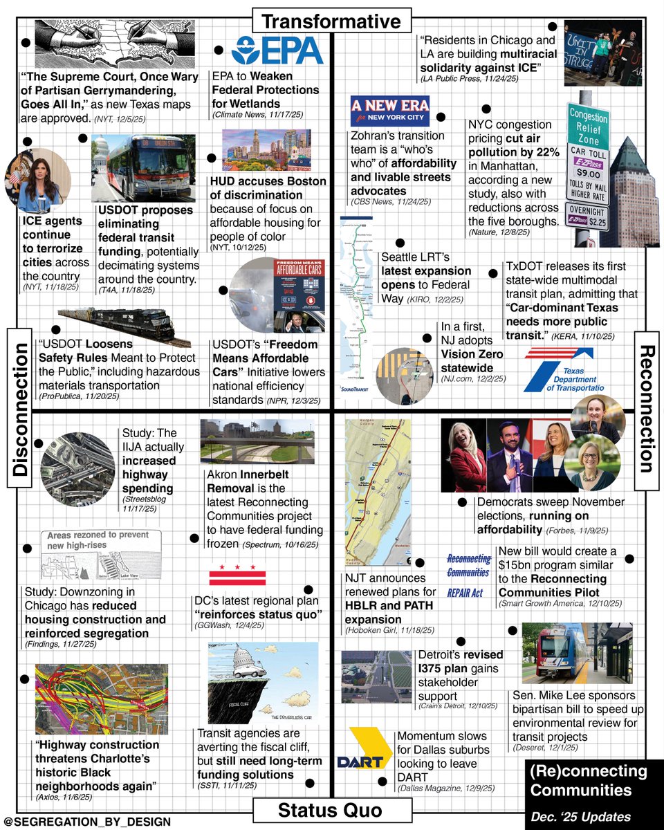
13 Dec 2025
Latest updates on “Reconnecting Communities” news, arrayed along two axes: one comparing progress towards reconnection vs. the opposite; and another transformative change (for better or worse) vs. incremental. More info and links: segregationbydesign.com/reco…
1
7
1,208
Segregation_by_Design retweeted

3 Dec 2025
Our cities weren't built for the car.
They were actively destroyed for it.
🍿 Come and join the screening of a documentary by @SegByDesign about the tremendous effort to build the Brooklyn-Queens Expressway.
🎞️: Dec 8th, 17:30
📍: Berlagezalen, @tudelft
🫰: 🆓
👇Sign up info
12
79
541
511,263
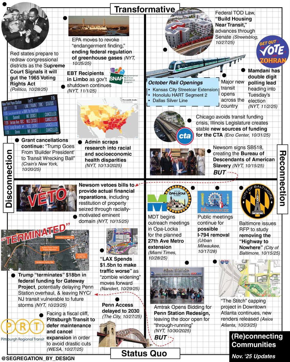
2 Nov 2025
Update on “Reconnecting Communities” news, arrayed along two axes: one comparing progress towards reconnection vs. the opposite; and another transformative change (for better or worse) vs. incremental. More info and links: segregationbydesign.com/reco…
1
13
1,913
15 Oct 2025
Nice read. "Canal communities are tied together by this piece of infrastructure and it’s not very clear what it’s for or what needs to happen to it. So there’s an interesting [opportunity] for urbanism that is not necessarily based on growth.”
bloomberg.com/news/features/…
3
1,280
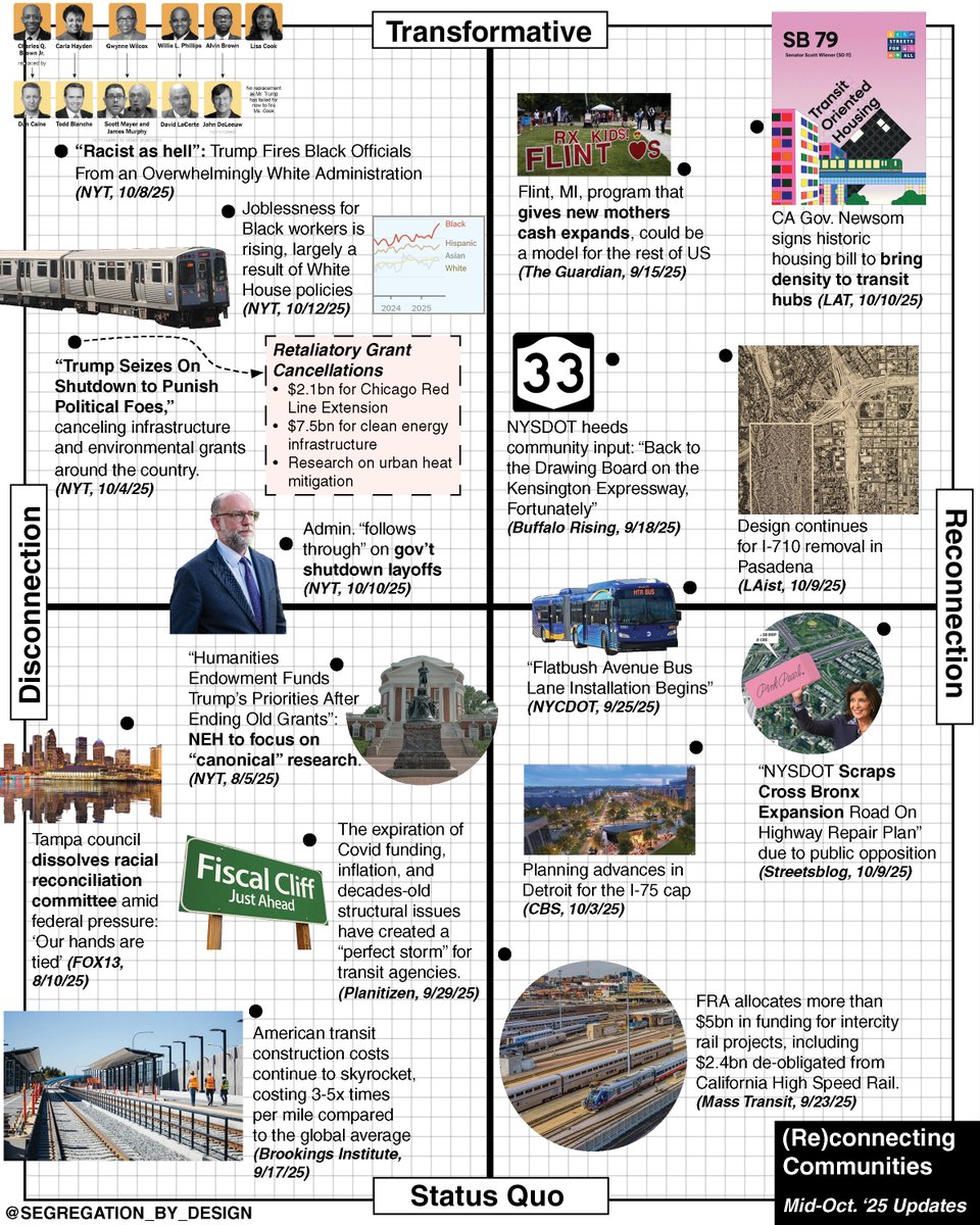
13 Oct 2025
Overview of mid-October “Reconnecting Communities” news, arrayed along two axes: one comparing progress towards reconnection vs. the opposite; and another transformative change (for better or worse) vs. incremental. More info and links: segregationbydesign.com/reco…
2
1,403
Segregation_by_Design retweeted

6 Oct 2025
It's not just the highways and "Urban Renewal" projects decimating cities, but the large, consolidated blocks that sap the life out of neighborhoods.
15
61
574
13,851
6 Oct 2025
Overview of last month's “Reconnecting Communities” news, arrayed along two axes: one comparing progress towards reconnection vs. the opposite; and another transformative change (for better or worse) vs. incremental. More info and links: segregationbydesign.com/reco…
2
8
1,763
Segregation_by_Design retweeted

EDGI and our collaborators at Public Environmental Data Partners are ensuring federal data is backed up, including the CDC's Social Vulnerability Index and Environmental Justice Index.
theverge.com/news/604484/don…
1
8
2,337
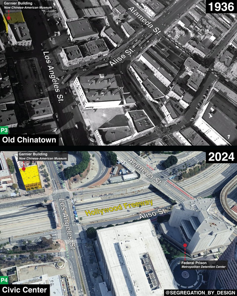
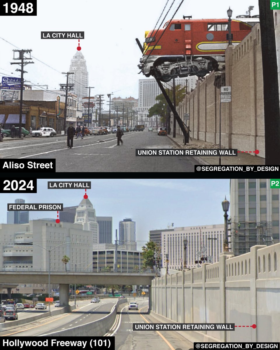
19 Dec 2024
View of Aliso St. in Downtown LA, before-and-after it was transformed into a frontage road for the 101. Aliso was the Pacific Electric's only route across the LA River, and conversion of the street to a highway in 1951 resulted in the abandonment of all lines east of the river.
5
56
545
22,178
Segregation_by_Design retweeted

7 Dec 2024
The entire US real estate market is priced around distance from black neighborhoods.
1,169
2,364
44,284
4,347,812

#30DayMapChallenge Day 21 — Conflict
Today’s highlight, inspired by the ongoing analysis of urban inequality in US cities by Adam Susaneck of @SegByDesign, was built by Mapboxer James Piacentini. This map shows the overlap of areas of “urban renewal” and public housing in New York City with historic redlining maps produced by the Home Owners’ Loan Corporation (HOLC).
Explore the map style here: labs.mapbox.com/map-design-d…
1
5
36
4,569
Segregation_by_Design retweeted

22 Oct 2024
I voted by mail – it was easy and a great excuse to say hi to some neighbors. If you're voting by mail like me, get your ballot in the mail right away. No matter how you vote, make sure you have a plan and get it done: IWillVote.com/Obama
14,887
19,509
133,307
22,990,952
Segregation_by_Design retweeted
26 Mar 2024
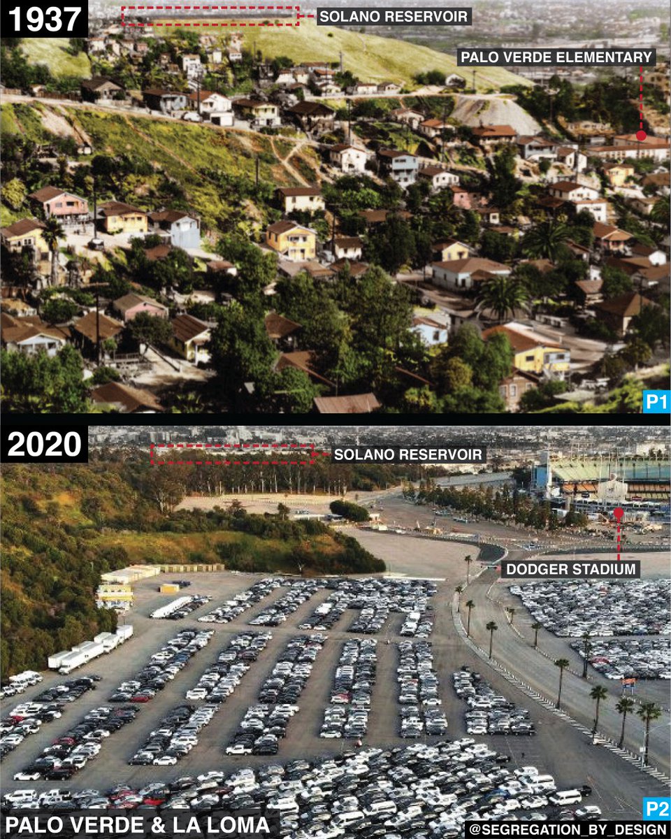
The Mexican-American community of Palo Verde, before-and-after the government forcibly evicted residents and demolished the neighborhood in the 1950s. The site was then used to build Dodger Stadium—more precisely: the Dodger Stadium parking lot.
12
646
2,750
105,238