
welcome to the official StormTrackingHQ twitter account this twitter account will only tweet about models, SPC risk, Watches issued by NWS
Joined June 2023
- Tweets 4,873
- Following 147
- Followers 412
- Likes 38
4,479 Photos and videos


Pinned Tweet

17 Jul 2025
youtube.com/@stormtrackinghq…
#wxtwitter #wxX #severewx #severe #severeweather #Tornado #flood #flashflood #winterwx #TornadoAlley #DixieAlley #HoosierAlley #CarolinaAlley
1
1
5,908
#SevereThunderstormWatch 0332 has been issued for parts of #Oklahoma and #Arkansas until 5:00 am CDT #wxtwitter #wxX #wx #severewx #severe #severeweather #EnhancedRisk #TornadoAlley #okcwx #okwx #OKwx #arwx #ARwx #FayettevilleAR #MiamiOK #Bartlesville #Tusla #Owasso #BrokenArrow #Stillwater #OklahomaCity #Norman #Muskegon #McAlester #FortSmith #Russellville
Probability Hazards
#Tornadoes
20/5%
#Wind
80/60%
#Hail
20/10%
Combined Severe Hail/Wind
90%
Tornadoes
A couple #tornadoes possible
Hail
Isolated #hail up to ping pong size possible
Wind
Widespread gusts up to 80 MPH likely
Population
3,896,578
Schools
1,409
Hospitals
132
1
128
#SevereThunderstormWatch 0331 has been issued for parts of #Kansas and #Missouri until 4:00 am CDT #wxtwitter #wxX #wx #severewx #severe #severeweather #EnhancedRisk #TornadoAlley #kswx #KSwx #mowx #MOwx #Joplin #Branson #SpringfieldMO #Pittsburg
Probability Hazards
#Tornadoes
20/10%
#Wind
70/50%
#Hail
20/10%
Combined Severe Hail/Wind
90%
Tornadoes
A couple #tornadoes possible
Hail
Isolated #hail up to ping pong size possible
Wind
Scattered gusts up to 80 MPH likely
Population
988,361
Schools
431
Hospitals
30
1
136
Severe Weather MDs 0443 has been issued for parts of #Kansas and #Missouri
Concerning: Tornado and Severe Thunderstorm Watches #327, #329
#Tornado: 100-125 mph
#Wind: 65-80 mph
#Hail: 1.50-2.50 in.
Valid until 10:00 pm CDT Today
#wxtwitter #wxX #wx #severewx #severe #severeweather #EnhancedRisk #TornadoAlley #kcwx #kswx #KSwx #mowx #MOwx #KansasCity #EmporiaKS #Topeka #Olathe #LawrenceKS #LeeSummit #OverlandPark #McPherson #JunctionCity
1
120
#TornadoWatch 0330 has been issued for #Oklahoma, #Missouri and #Arkansas until 11:00 pm CDT #wxtwitter #wxX #wx #severewx #severe #severeweather #EnhancedRisk #Tornado #TornadoAlley #DixieAlley #okwx #OKwx #mowx #MOwx #arwx #ARwx #Bartlesville #PoncaCity #FayettevilleAR #Tusla #BrokenArrow #Owasso #MiamiOK #Branson
Probability Hazards
#Tornadoes
50/30%
#Wind
40/30%
#Hail
40/30%
Combined Severe Hail/Wind
70%
Tornadoes
A couple strong #tornadoes possible
Hail
Scattered #hail up to tennis ball size possible
Wind
Scattered gusts up to 75 MPH possible
Population
1,944,923
Schools
678
Hospitals
64
1
234
Severe Weather MDs 0442 has been issued for parts of #Kansas, #Missouri, #Oklahoma and #Arkansas
Concerning: Severe Potential Watch Possible
Watch Probability: 40%
#Tornado: 100-125 mph
#Wind: 65-80 mph
#Hail: 1.50-2.50 in.
Valid until 7:30 pm CDT Today
#wxtwitter #wxX #wx #severewx #severe #severeweather #EnhancedRisk #TornadoAlley #DixieAlley #okwx #OKwx #mowx #MOwx #arwx #ARwx #kswx #KSwx #FayettevilleAR #Bartlesville #MiamiOK #Joplin
1
85
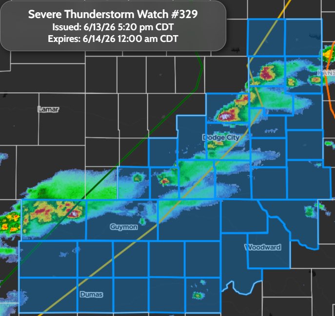
#SevereThunderstormWatch 0329 has been issued for parts of #Kansas, #Texas and #Oklahoma until 12:00 am CDT #wxtwitter #wxX #wx #severewx #severe #severeweather #EnhancedRisk #TornadoAlley #phwx #txwx #TXwx #okwx #OKwx #kswx #KSwx #RussellKS #HaysKS #LiberalKS #GreatBend #DodgeCity #GuymonOK #Dalhart #Woodward #Perryton #Borger
Probability Hazards
#Tornadoes
10/<2%
#Wind
40/30%
#Hail
40/30%
Combined Severe Hail/Wind
70%
Hail
Scattered #hail up to tennis ball size possible
Wind
Scattered gusts up to 75 MPH possible
#Lightning
Frequent #lightning possible
Population
309,525
Schools
282
Hospitals
39
1
80
#SevereThunderstormWatch 0328 has been issued for parts of #Nebraska, #Iowa, #Missouri and #Kansas until 11:00 pm CDT #wxtwitter #wxX #wx #severewx #severe #severeweather #EnhancedRisk #kcwx #kswx #KSwx #newx #NEwx #mowx #MOwx #iawx #IAwx #LincolnNE #BeatriceNE
Probability Hazards
#Tornadoes
20/5%
#Wind
40/20%
#Hail
60/40%
Combined Severe Hail/Wind
90%
Tornadoes
A couple #tornadoes possible
Hail
Scattered #hail up to two inch size likely
Wind
Scattered gusts up to 70 MPH possible
Population
549,843
Schools
315
Hospitals
39
1
161
#TornadoWatch 0327 has been issued for parts of #Kansas and #Missouri until 11:00 pm CDT #wxtwitter #wxX #wx #severewx #severe #severeweather #EnhancedRisk #Tornado #kcwx #kswx #KSwx #mowx #MOwx #LawrenceKS #EmporiaKS #JunctionCity #ManhattanKS #StJosephMO #Topeka #OverlandPark #KansasCity #Olathe #LeeSummit #Salina #McPherson
Probability Hazards
#Tornadoes
40/20%
#Wind
70/50%
#Hail
60/40%
Combined Severe Hail/Wind
>95%
Tornadoes
A couple #tornadoes possible
Hail
Scattered #hail up to tennis ball size likely
Wind
Scattered gusts up to 75 MPH likely
Population
2,978,204
Schools
1,157
Hospitals
95
1
148
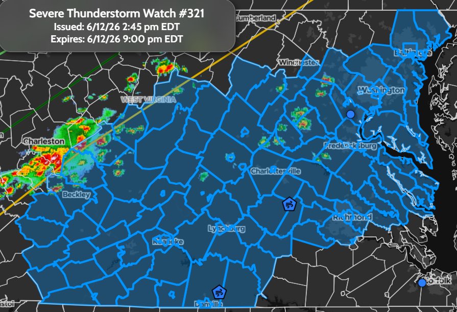
#SevereThunderstormWatch 0321 has been issued for parts of #Virginia, #DC, #Maryland and #WestVirginia until 9:00 pm EDT #wxtwitter #wxX #wx #severewx #severe #severeweather #SlightRisk #vawx #VAwx #dcwx #DCwx #mdwx #MDwx #wvwx #WVwx #RichmondVA #Charlottesville #Danville #Blackburg #Beckley #Staunton #Lynchburg #Harrisonburg #Annapolis #Baltimore #WashingtonDC #ColumbiaMD #SliverSprings #Fredericksburg
Probability Hazards
#Tornadoes
<5/<2%
#Wind
60/20%
#Hail
20/10%
Combined Severe Hail/Wind
80%
Hail
Isolated #hail up to quarter size possible
Wind
Scattered gusts up to 70 MPH likely
#Lightning
Frequent #lightning possible
Population
12,262,897
Schools
3,059
Hospitals
159
1
41
#SevereThunderstormWatch 0319 has been issued for parts of #Indiana, #Ohio and #Illinois until 3:00 am EDT #wxtwitter #wxX #wx #severewx #severe #severeweather #EnhancedRisk #HoosierAlley #ilwx #ILwx #inwx #INwx #ohwx #OHwx #Effingham #Indianapolis #DaytonOH #Richmond #Muncie #ColumbusIN #BloomingtonIN #TerreHaute
Probability Hazards
#Tornadoes
20/<2%
#Wind
50/20%
#Hail
10/10%
Combined Severe Hail/Wind
70%
Tornadoes
A couple #tornadoes possible
Hail
Isolated #hail up to quarter size possible
Wind
Scattered gusts up to 70 MPH possible
Population
5,018,074
Schools
1,479
Hospitals
101
1
262
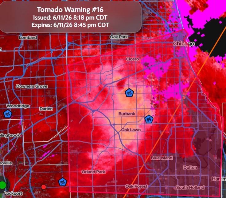
#TornadoWarning 016 has been issued for #Chicago IL, Cicero IL, Orland Park IL until 8:45 pm CDT #wxtwitter #wxX #wx #severewx #severe #severeweather #EnhancedRisk #HoosierAlley #ilwx #ILwx
#Tornado
Radar indicated
#Hail
No #hail expected
Population
2,361,533
Schools
673
Hospitals
32
1
2
1,705
#TornadoWarning 015 has been #GrandRapids MI, Wyoming MI and Kentwood MI until 9:45 pm EDT #wxtwitter #wxX #wx #severewx #severe #severeweather #EnhancedRisk #HoosierAlley #miwx #MIwx
#Tornado
Radar indicated
#Hail
Pea sized possible
Population
609,641
Schools
218
Hospitals
8
1
293
#TornadoWarning 014 has been Downers Grove IL, Elmhurst IL and Lombard IL until 8:30 pm CDT #wxtwitter #wxX #wx #severewx #severe #severeweather #EnhancedRisk #HoosierAlley #ilwx #ILwx #Naperville
#Tornado
Radar indicated
#Hail
No hail expected
Population
472,405
Schools
111
Hospitals
5
1
1
2,351
#PDS #TornadoWarning 047 has been issued for Portage IN, Chesterton IN and South Haven IN until 8:30 pm CDT #wxtwitter #wxX #wx #severewx #severe #severeweather #ModerateRisk #HoosierAlley #inwx #INwx
#Tornado
Damaging tornado
#Hail
Pea sized possible
⚠️This is a Life Threatening Situation. Seek shelter now!
Population
104,713
Schools
26
Hospitals
2
1
448
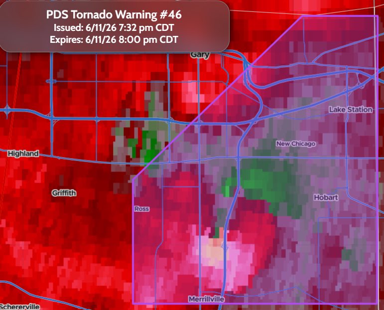
#PDS #TornadoWarning 046 has been issued for Merrillville IN, Hobart IN and Lake Station IN until 8:00 pm CDT #wxtwitter #wxX #wx #severewx #severe #severeweather #ModerateRisk #HoosierAlley #inwx #INwx
#Tornado
Damaging tornado
#Hail
Pea sized possible
⚠️This is a Life Threatening Situation. Seek shelter now!
Population
86,787
Schools
37
Hospitals
2
1
1,168
#TornadoWatch 0318 has been issued for parts of #Indiana, #Illinois, #Ohio and #Michigan until 2:00 am EDT #wxtwitter #wxX #wx #severewx #severe #severeweather #ModerateRisk #Tornado #HoosierAlley #ilwx #ILwx #inwx #INwx #miwx #MIwx #ohwx #OHwx #Saginaw #Lansing #SouthBend #FortWayne #LafayetteIN #Logansport #DecaturIL #DanvilleIL #Kalamazoo #GrandRapids #Muskegon #Flint #MidlandMI
Probability Hazards
#Tornadoes
50/30%
#Wijd
80/60%
#Hail
30/20%
Combined Severe Hail/Wind
>95%
Tornadoes
A couple strong #tornadoes possible
Hail
Isolated #hail up to ping pong size possible
Wind
Widespread gusts up to 75 MPH likely
Population
6,921,872
Schools
2,847
Hospitals
159

1
1
585
Severe Weather MDs 0441 has been issued for #Illinois, #Indiana and #Wisconsin
Concerning: Tornado Watch #313
#Tornado: 140-170 mph
#Wind: 65-80 mph
#Hail: 1.00-1.75 in.
Valid until 7:45 pm CDT Today
#wxtwitter #wxX #wx #severewx #severe #severeweather #ModerateRisk #HoosierAlley #swiwx #ilwx #ILwx #wiwx #WIwx #inwx #INwx #SpringfieldIL #Peoria #BloomingtonIL #LincolnIL #GaryIN #HammondIN #Joliet #Chicago #Naperville #Kenosha #Rockford #DeKalb #ElginIL #AuroraIL

1
1,062
#PDS #TornadoWarning 045 has been issued for Dwight IL, Odell IL and Essex IL until 6:45 pm CDT #wxtwitter #wxX #wx #severewx #severe #severeweather #ModerateRisk #HoosierAlley #ilwx #ILwx
#Tornado
Damaging tornado
#Hail
Half dollar sized possible
⚠️This is a Life Threatening Situation. Seek shelter now!
Population
7,619
Schools
5
Hospitals
1

1
297
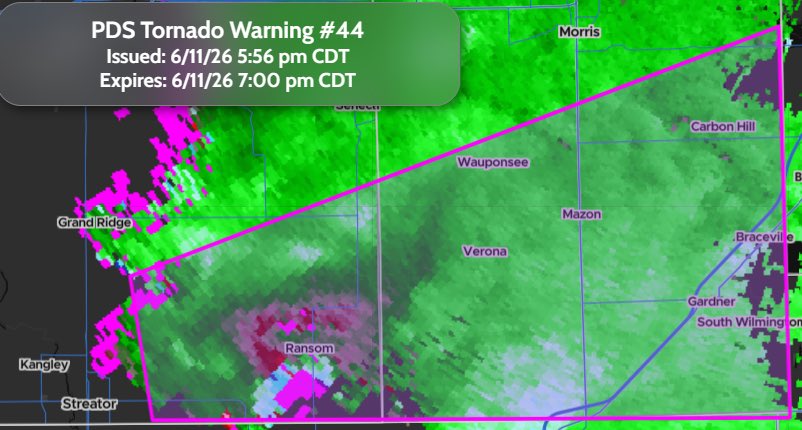
#PDS #TornadoWarning 044 has been issued for Coal City IL, Diamond IL and Gardner IL until 7:00 pm CDT #wxtwitter #wxX #wx #severewx #severe #severeweather #ModerateRisk #HoosierAlley #ilwx #ILwx
#Tornado
Damaging tornado
#Hail
Half dollar sized possible
⚠️This is a Life Threatening Situation. Seek shelter now!
Population
16,326
Schools
12
Hospitals
0
1
1
319
Severe Weather MDs 0440 has been issued for #Illinois
Concerning: Tornado Watch #313
#Tornado: 140-170 mph
#Wind: 65-80 mph
#Hail: 1.50-2.50 in.
Valid until 6:15 pm CDT Today
#wxtwitter #wxX #wx #severewx #severe #severeweather #HoosierAlley #ilwx #ILwx #Joliet

1
407