Starting as early as March 9, traffic on the Mt Lehman structure across #BCHwy1 in #Abbotsford will go from 3 to 2 lanes for construction of an improved 5 lane structure. Work planned until the end of 2026.
Learn more: news.gov.bc.ca/releases/2026…
EmergencyInfoBC is also on Facebook: facebook.com/EmergencyInfoBC
We share verified updates, instructions & links to official sources during emergencies in #BC, including floods, wildfires, earthquakes & tsunamis.
Follow our Facebook page for trusted emergency information, alongside our posts here on X. #BCFlood#BCWildfire#BCEarthquake
ALT Follow & share EmergencyInfoBC on both Facebook and X.
Help shape the future of DriveBC!
Participate in user research to provide feedback on the website.
Those selected and who participate will receive a gift card in appreciation of their time. #BCTrucking#BCTrks#BCHwys @DricveBC
Sign up: forms.cloud.microsoft/r/jJjA…
The Keating Cross Rd southbound onramp to #BCHwy17 (Pat Bay Hwy) is scheduled to open Saturday morning (Jan 24) following improvement work.
The area remains an active work zone, follow signage and use caution.
Check @DriveBC for updates. #Saanichnews.gov.bc.ca/releases/2026…
🚧⛔#BCHwy3 - Paving operations officially underway westbound between Exit 177 and Exit 171 until 4:30 PM this afternoon. Westbound travelers MUST use Exit 173: Old Hope Princeton Way in #HopeBC to access #BCHwy1.
ℹ️For more info: drivebc.ca/?pan=-121.4884918…
🚧⛔️ HEADS UP 👋 #BCHwy3 - Paving operations will have westbound closed between Exit 177 and Exit 171 between 7AM to 4:30 PM. Westbound travelers MUST use Exit 173: Old Hope Princeton Way in #HopeBC to access #BCHwy1. Expect delays, and be aware of crews and equipment. #CrowsnestHwy
ℹ️For more info:
drivebc.ca/?pan=-121.3483604…
Overnight lane closures planned for George Massey Tunnel starting Sun, Jan 11 #RichmondBC#YVR#BCHwy99
Overnight single-lane closures to continue through March, prep for construction of the new tunnel.
More details: news.gov.bc.ca/releases/2026…
1
1
1,716
BC Ministry of Transportation and Transit retweeted
The #BC River Forecast Centre has UPGRADED the High Streamflow Advisory to a Flood Watch for #VancouverIsland including Englishman River & the South Coast including Sunshine Coast, Howe Sound & #SeatoSky. Avoid fast-flowing rivers & potentially unstable riverbanks. Info: bcrfc.env.gov.bc.ca/warnings…#BCFlood
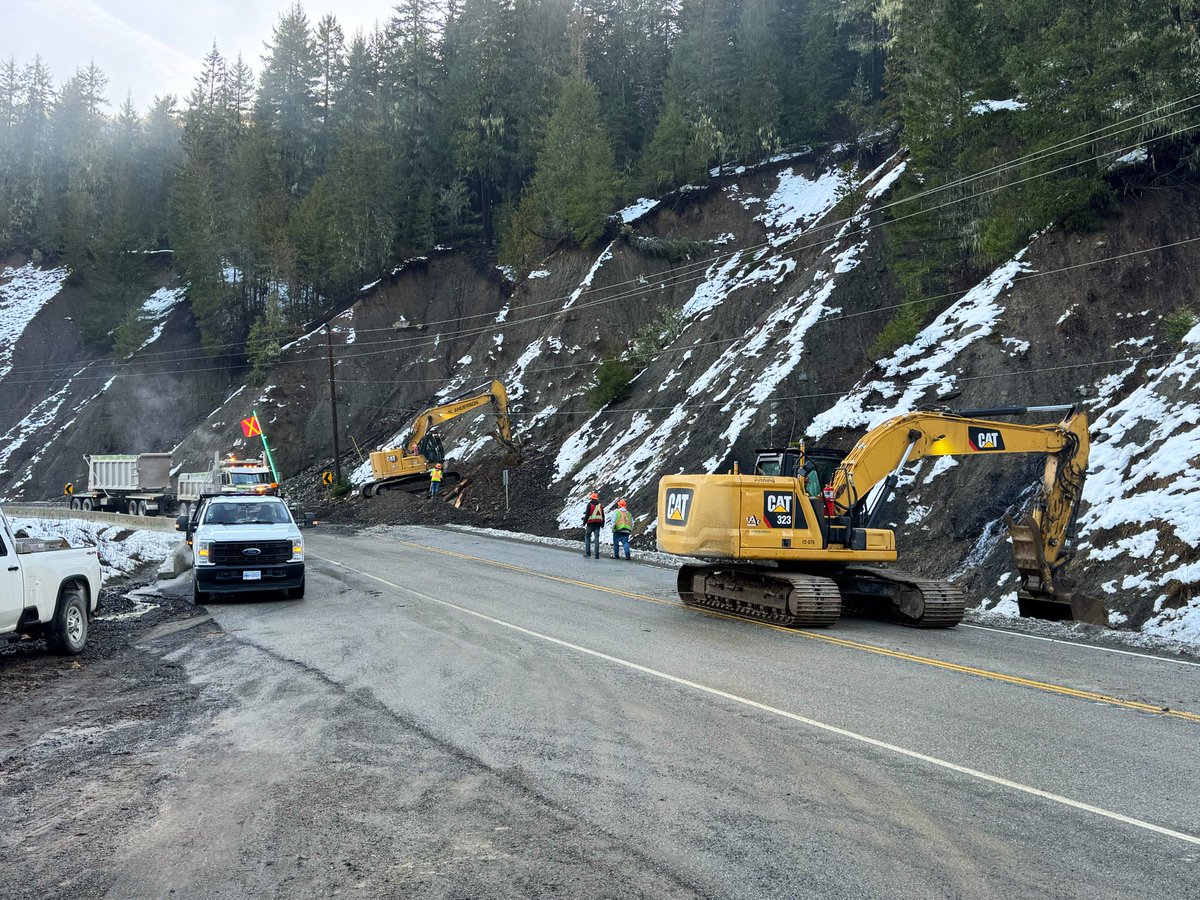
ALT Flood Warning for the Chilliwack River and its tributaries, as well as the North Shore Mountains.
Flood Watch for tributaries of the Lower Fraser, including the Lillooet River and tributaries around Pemberton, the Fraser Valley, the Fraser Canyon and the Coast Mountains. A separate Flood Warning remains in effect for the Sumas River. A Flood Watch is also in place for the Kingcome River, Vancouver Island including the Englishman River, and the South Coast including the Sunshine Coast, Howe Sound and the Sea-to-Sky corridor.
High Streamflow Advisory for Haida Gwaii, the North Coast including Kitimat, Prince Rupert and surrounding areas, and the Central Coast.
35
52
14,837
BC Ministry of Transportation and Transit retweeted
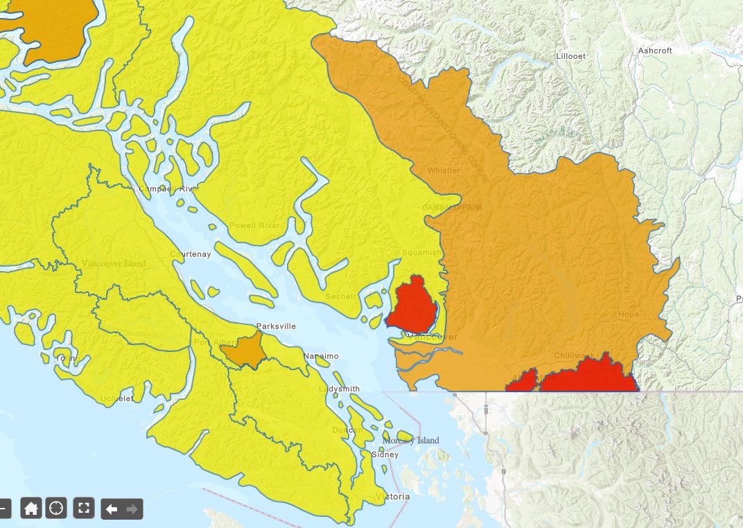
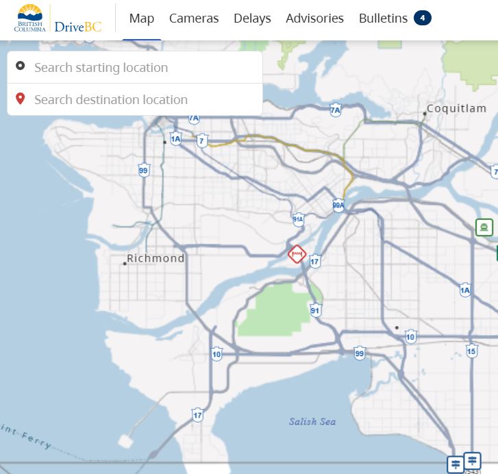
ALT Map of area depicting current flood warning levels around the South coastal region of BC. River Forecast Centre has upgraded the Flood Watch to a Flood Warning for the North Shore Mountains area.
1
65
95
25,730
BC Ministry of Transportation and Transit retweeted
⚠️ UPDATE #BCHwy1 - The eastbound left lane has been reopened between #BCHwy9 and #HopeBC. The right lane remains closed.
Additionally, the westbound left lane will be closed while crews continue cleanup.
A 50km/hr speed limit is in effect for both directions. Watch for crews and expect delays.
1
3
13,699
BC Ministry of Transportation and Transit retweeted
🚧 #BCHwy3 Update:
Crews hard at work doing slope & culvert repairs, debris cleanup & shoulder restoration.
This 📸 shows 1 of 23 active sites in the corridor.
✅ Repair work ongoing.
⏳ No estimated reopening yet, but response work is well underway.
drivebc.ca/?pan=-121.0568304…