
Emergency Management means being ready and YOU are your own best first responder. Follow us to learn how to stay #LonghornReady for any emergency on campus.
- Tweets 2,287
- Following 344
- Followers 2,151
- Likes 2,399


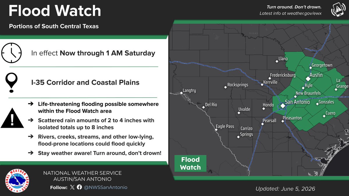
ALT National Weather Service graphic titled "Flood Watch" announces an alert in effect from now through 1 AM Saturday for the I-35 Corridor and Coastal Plains of South Central Texas. An accompanying map highlights the watch area in green, covering cities from Llano and Georgetown down through Austin, San Antonio, and Cuero. Listed impacts warn of possible life-threatening flooding, scattered rainfall totals of 2 to 4 inches with isolated amounts up to 8 inches, and rapidly flooding low-lying areas.

ALT National Weather Service weather graphic titled "Storm Timing This Evening - Early Saturday" features a map highlighting "Area 1" in blue across South Central Texas, warning of pockets of heavy rain and frequent lightning. A corresponding table lists the timing for Area 1 as starting as early as 2 PM Friday, most likely between 4 PM and 11 PM Friday, and ending by 1 AM Saturday. Explanatory text notes that the area of storms will move slowly east during the afternoon and evening.


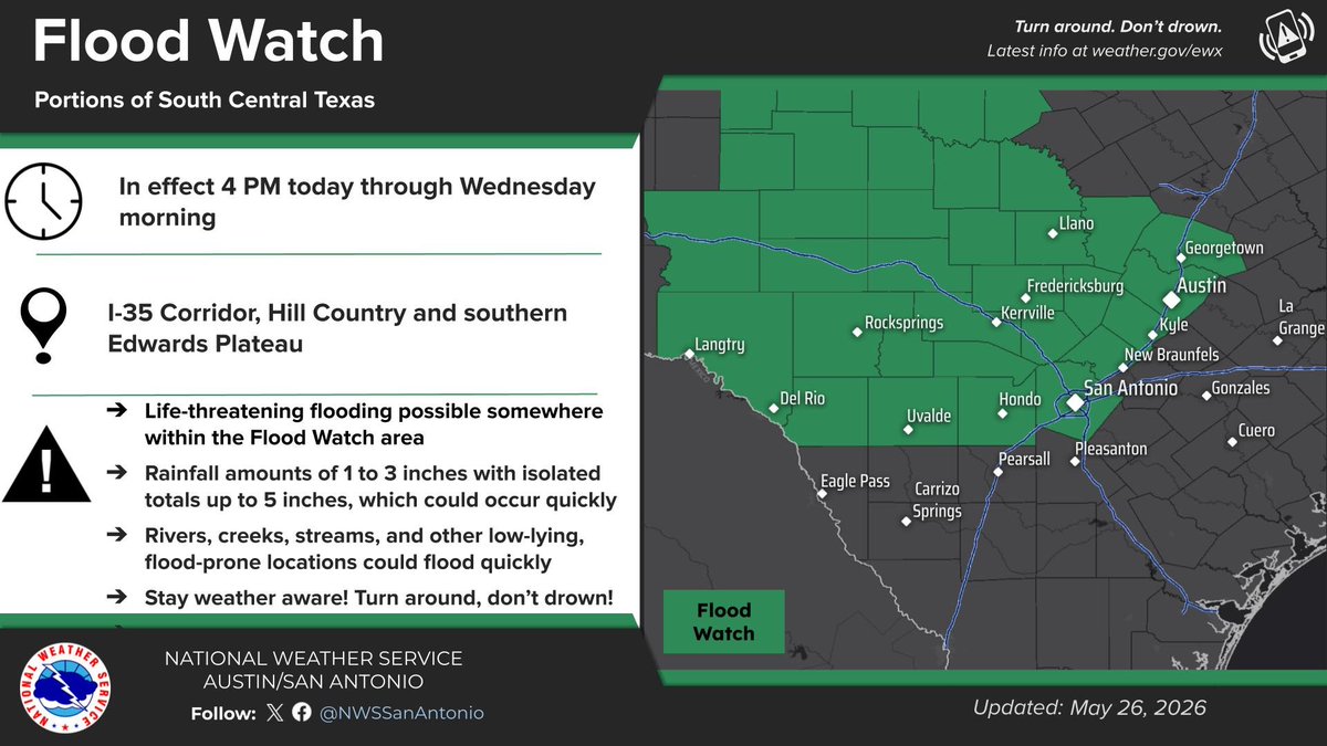
ALT This official weather graphic from the National Weather Service Austin/San Antonio, updated May 26, 2026, announces a Flood Watch for South Central Texas. Timing: In effect from 4 PM today through Wednesday morning. Coverage: The watch includes the I-35 Corridor, Hill Country, and the southern Edwards Plateau. Cities Added/Included: Rocksprings, Uvalde, and Del Rio are now within the green-shaded watch zone, alongside San Antonio, Austin, Fredericksburg, and Llano. Key Threats: * Rainfall of 1 to 3 inches, with isolated pockets up to 5 inches. Potential for rapid, life-threatening flooding of rivers, creeks, and low-lying areas. Action: "Turn around. Don’t drown."
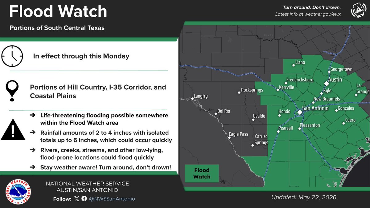
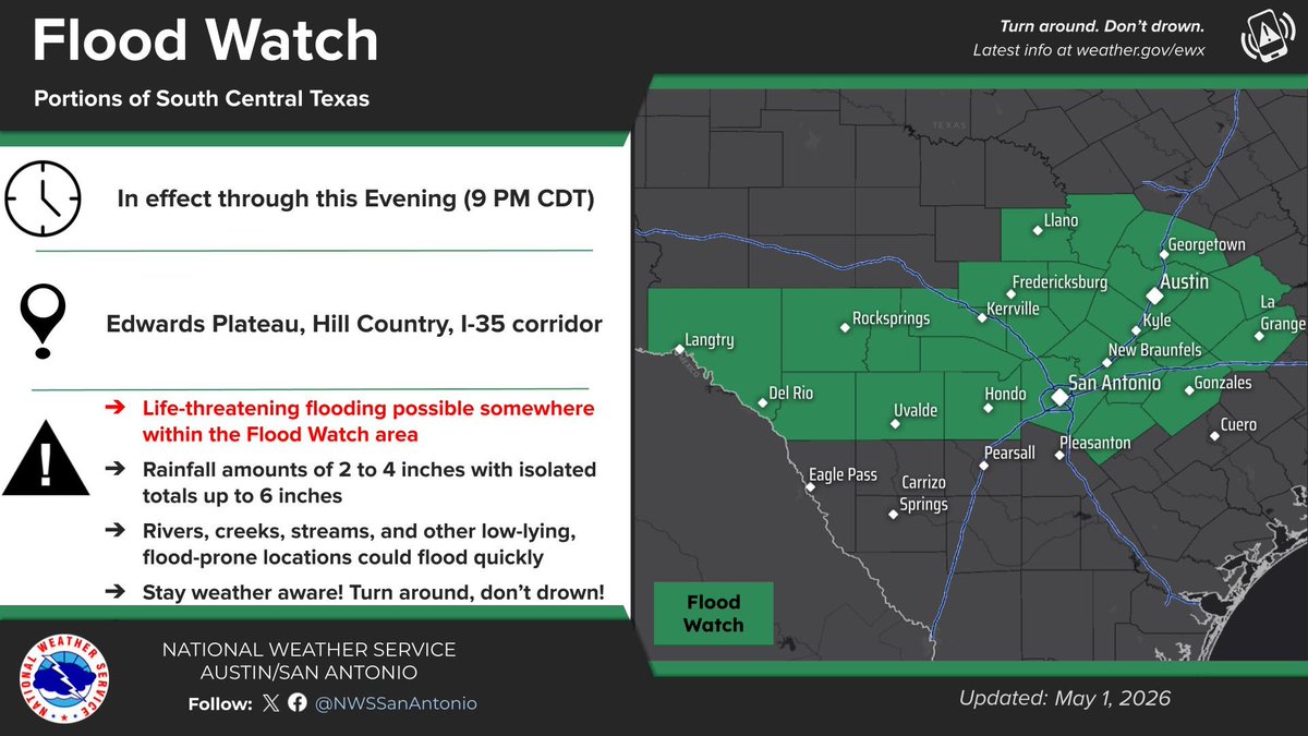
ALT Flood Watch map graphic for South Central Texas, including portions of the Hill Country, I-35 Corridor, and Coastal Plains, in effect through this Monday. Life-threatening flooding is possible with 2 to 4 inches of rain, and isolated totals up to 6 inches, occurring quickly. Rivers, creeks, and flood-prone locations could flood rapidly. Remember: Turn around, don't drown. National Weather Service Austin/San Antonio.1
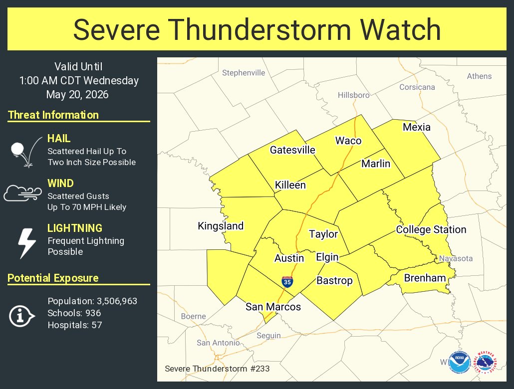
ALT This graphic displays Severe Thunderstorm watch number 233 plotted on a map. The watch is in effect until 1:00 AM CDT. The watch includes parts of Texas. The threats associated with this watch are no tornadoes expected, scattered hail up to two inch size possible and scattered gusts up to 70 mph likely. There are 3,506,963 people in the watch along with 936 schools and 57 hospitals.
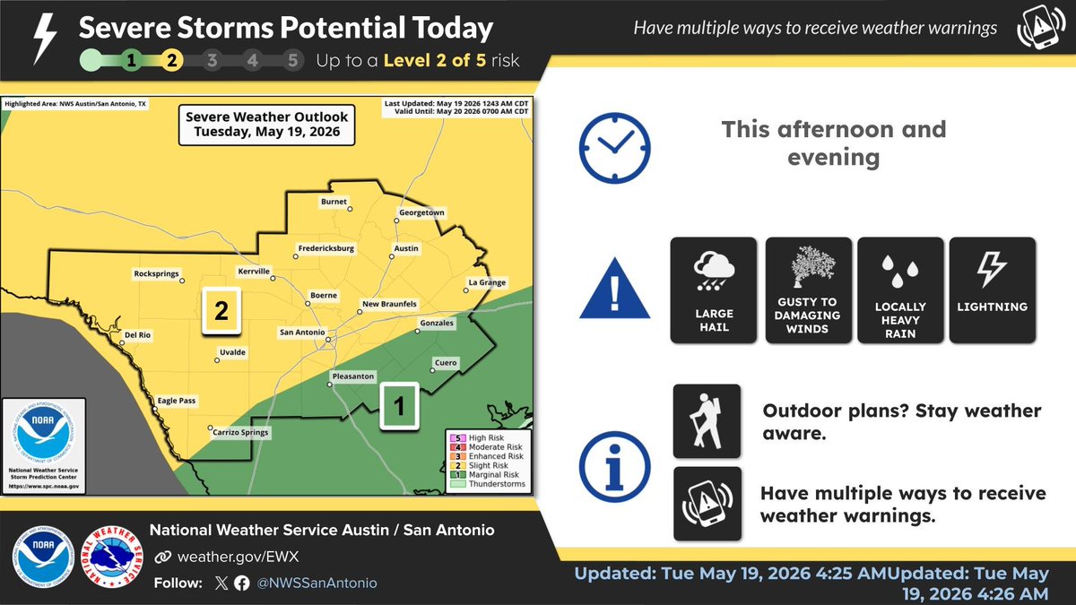
ALT Severe Storm Potential Outlook graphic from the National Weather Service Austin/San Antonio for Tuesday Evening into Tuesday Night. The risk is up to a Level 2 out of 5 for severe thunderstorms. Hazards include damaging wind, large hail, isolated tornadoes (brief tornado possible), and locally heavy rain. You should review safety plans and monitor the forecast.
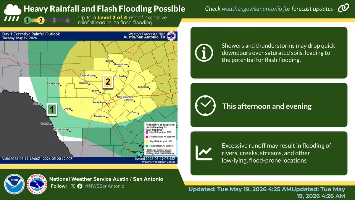
ALT Excessive Rainfall Outlook graphic from the National Weather Service Austin/San Antonio, showing an elevated risk of flash flooding for the region this afternoon and evening. There is up to a Level 2 out of 4 risk of excessive rainfall, meaning showers and thunderstorms may drop quick downpours over saturated soils. This could result in excessive runoff and flooding of rivers, creeks, streams, and other low-lying, flood-prone locations. Check weather.gov/sanantonio for forecast updates.
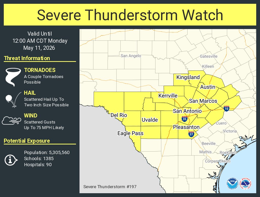
ALT This graphic displays Severe Thunderstorm watch number 197 plotted on a map. The watch is in effect until 12:00 AM CDT. The watch includes parts of Texas. The threats associated with this watch are a couple tornadoes possible, scattered hail up to two inch size possible and scattered gusts up to 75 mph likely. There are 5,305,560 people in the watch along with 1385 schools and 90 hospitals.


ALT Flyer with \"TEXT UTGRAD26 TO 888777 FOR UPDATES AND ALERTS REGARDING SPRING COMMENCEMENT EVENTS.\" Icons for Parking/Traffic, Weather, Event Updates shown. Upper right shows \"Commencement 2026\", and lower right shows \"TEXAS The University of Texas at Austin\"

ALT The graphic shows the Flood Watch for portions of South Central Texas through this evening. Several rounds of heavy showers are anticipated which could lead to flooding. Stay weather aware and have ways set up to receive Flash Flood Warnings, including having Wireless Emergency Alerts enable on your phone.