
Joined August 2008
- Tweets 16,126
- Following 1,320
- Followers 45,972
- Likes 8,766
4,312 Photos and videos


Partly cloudy overnight, with some increasing clouds toward morning. Lows in the mid 60s inland to low 70s along the coast. We're still looking for scattered to numerous storms once again tomorrow afternoon and evening, with a few severe storms possible.
3
2
471
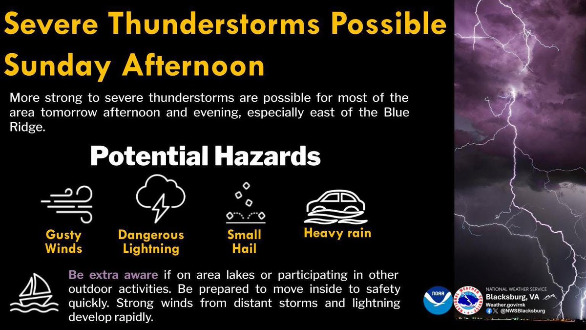
Chances of strong to severe storms for Sunday afternoon and evening are increasing. The greatest threat is damaging gusty winds, but small hail and heavy rain and localized flooding are also possible.
1
5
9
733
Stay weather aware tomorrow and have multiple ways to receive warnings!
weather.gov/rnk
1
433
High pressure will build into the region today. Most areas can expect mostly sunny skies throughout the day, but after some patchy morning fog for some location. Isolated showers are possible this afternoon over the North Carolina mountains.
1
2
6
766
Temperatures will be above normal, but cooler than Friday.
1
606
Happy Saturday! We are looking at a beautiful, mostly sunny, and warm day across the area, with the added bonus of less humidity. High temperatures will climb into the upper 80s to low 90s, dropping the upper 60s to low 70s tonight.
1
1
3
568
Winds will remain light out of the north-northeast. If you are down in portions of Northeast North Carolina, keep an eye on the sky as a scattered afternoon shower or storm is possible.
2
436
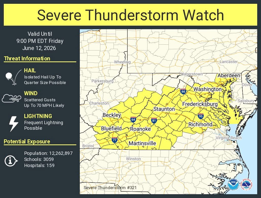
A severe thunderstorm watch has been issued for parts of District of Columbia, Maryland, Virginia and West Virginia until 9 PM EDT. Storms will be capable of damaging winds and isolated large hail.
1
6
497
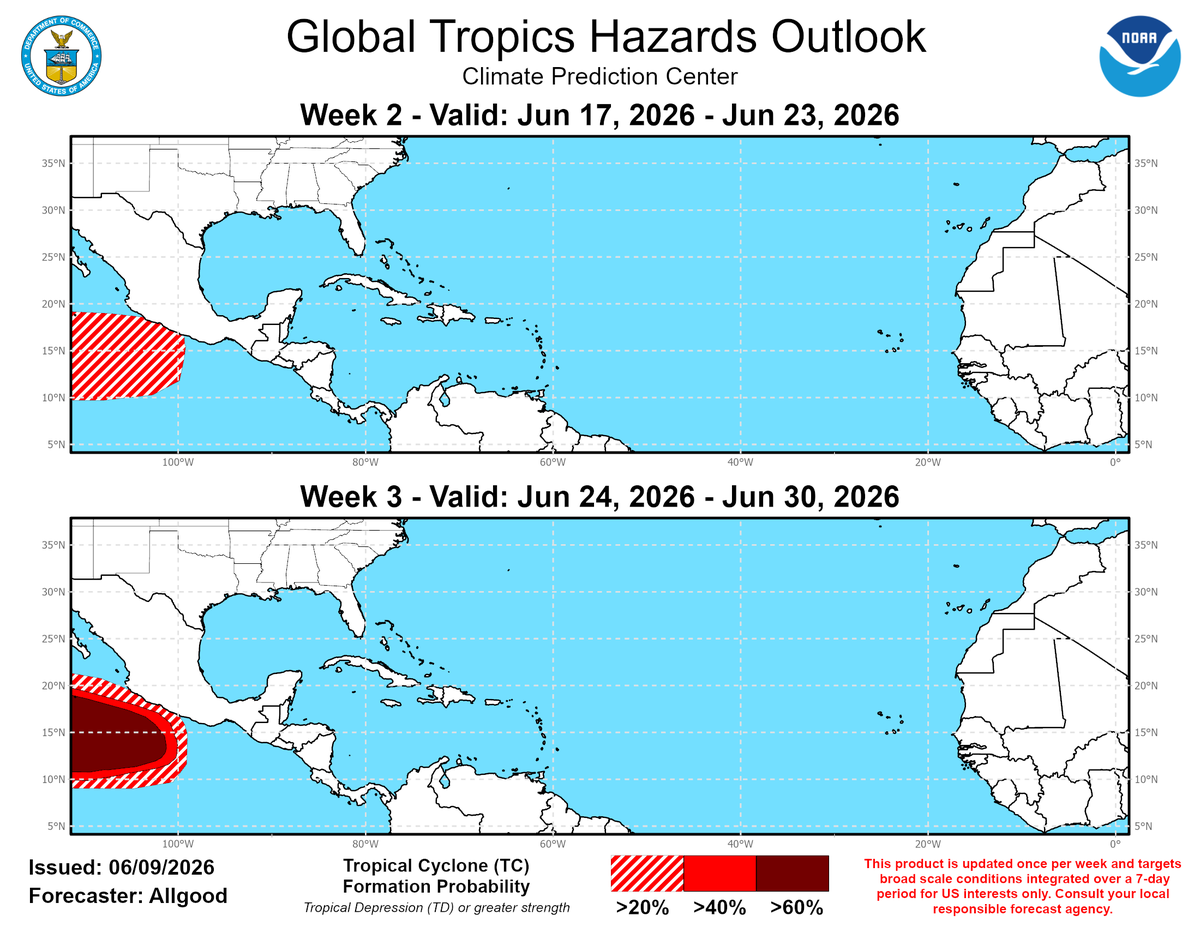
🤞While we are definitely not going to use the "Q" word, we're happy to provide this tropical weather update...No tropical cyclone development is expected in the Atlantic Basin through late-June.😎
1
1
10
814
🥵🔥☀HEAT WARNINGS are SERIOUS—Let’s Look Out for One Another!☀🥵🔥
It's important to check on our elderly and shut-ins during extreme heat. They are especially vulnerable to heat-related illnesses.
1
4
8
551
✅ Help arrange transportation to cooling centers if needed ✅ Remind them to wear lightweight, light-colored clothing and to avoid strenuous activity during peak heat hours
1
1
331
💙☀️Let’s stay connected and keep our community safe! Weather Proof Your World! 💙☀️ #VDEM #HeatSafety #CommunityCare #StayCool
1
239
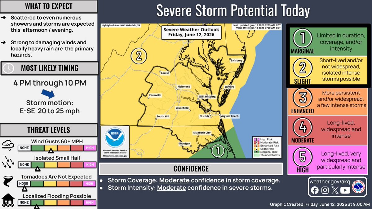
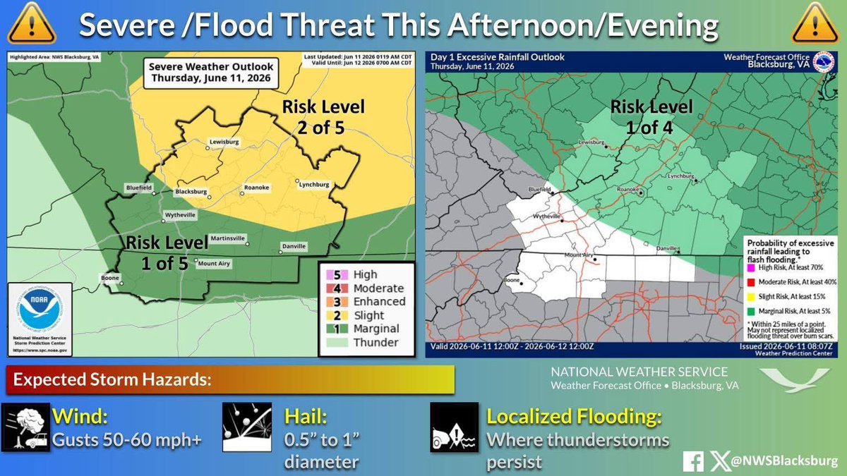
From intense heat to severe storms, it will be a busy weather day across the region. Most of the area is under a Slight Risk (2/5) for severe weather today, primarily between 4 PM and 10 PM.
3
2
12
1,193
The greatest threat from any severe storms will be damaging winds, with the highest potential across the northeast portion of the area. Isolated one inch hail is also possible.
1
583
Slow-moving storms capable of localized rainfall rates of 2 to 4 inches per hour, may pass across the same locations, resulting in flash flooding. Flash flooding may inundate roads, making them impassible. Urban areas with poor drainage are also susceptible to flash flooding.
2
3
523
The primary threats with these storms are damaging wind gusts over 60 mph and locally heavy rainfall.
3
467
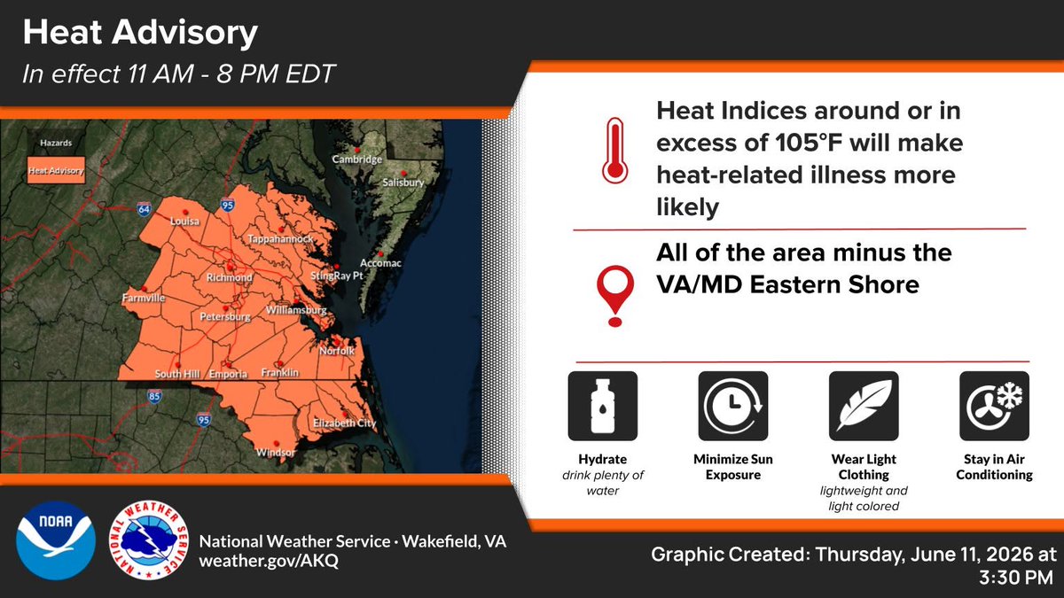
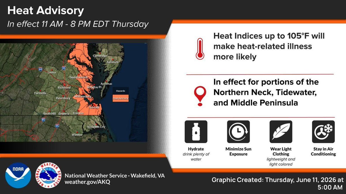
The combination of temperatures in the mid and upper 90s and high humidity will result in heat index values of 100-107 across the region Friday. The highest heat index readings will occur from the I-95 and I-85 corridor eastward toward the coast of SE VA and NE NC.
1
2
13
1,299
Here, values of 103-107 will possible. Strong to severe storms are also possible in the afternoon and evening hours.
3
1,011