
Vantor is forging the new frontier of spatial intelligence to unlock a more automated, interoperable world. Delivering total clarity from space to ground.
Joined October 2008
- Tweets 12,015
- Following 837
- Followers 139,043
- Likes 7,067
4,586 Photos and videos


Jun 12
When location, positioning, and context matter, trust in spatial data becomes mission critical.
Recent reporting from @arstechnica highlights growing concerns around GPS interference and the resilience of positioning systems. It is a reminder that organizations operating in complex or contested environments cannot rely on any single signal, source, or system to understand where they are and what is happening around them.
That is where Vantor’s spatial foundation plays an important role. Combining decades of imagery, global 2D basemaps, 3D terrain, and map-ready features, it provides a trusted source of ground truth for humans, machines, and AI-powered systems.
Raptor uses this trusted foundation as a reference point. By comparing a drone’s video feed to Vantor’s 3D data, Raptor supports navigation and coordinate generation when GPS may be unavailable, degraded, or unreliable. From identifying precise locations and extracted points to understanding spatial relationships across complex environments, Raptor helps deliver actionable insight when accuracy and confidence matter most.
The visual below shows a drone video feed using Raptor to navigate against Vantor’s 3D data. It reinforces a simple but critical idea: coordinate extraction is only as reliable as the data behind it, which is why a trusted spatial foundation matters to navigate.
Read the Ars Technica article for more context on GPS interference and resilience in the comments, then learn more about how Raptor supports navigation without GPS:
🔗: arstechnica.com/space/2026/0…
🔗: go.vantor.com/autonomy-witho…
1
5
18
2,754
Jun 11
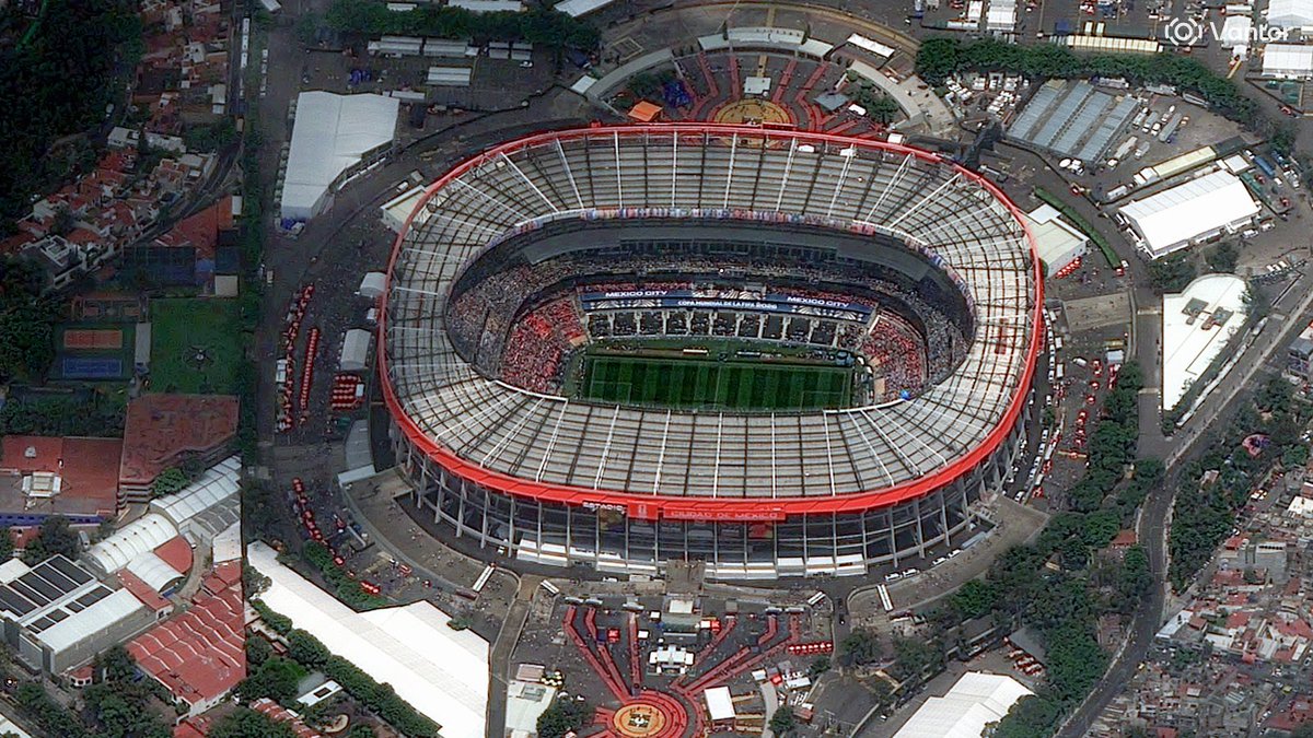
These images, collected today by Vantor satellites, show Estadio Azteca in Mexico City as it prepares to host one of global soccer’s biggest opening moments this year.
Captured just four minutes apart, the images offer two looks at the iconic stadium: a high off-nadir view from WorldView Legion at 12:08 PM local time, followed by a near-straight-down view from GeoEye-1 at 12:12 PM local time.
As teams around the world continue their road to the pitch, this Mexico City landmark is getting ready for a moment fans won’t forget.
Wishing every team the best as they chase the game’s biggest stage.

3
19
193
15,170
Jun 11
Utilities are being asked to prevent wildfire risk across vast, complex networks. But routine inspection and trimming cycles can leave teams with the same hard question: where should we act first?
Vantor helps answer that question from space.
By pairing high-resolution satellite imagery with @aidashinc utility-specific AI models, utilities can move from broad vegetation management to risk-based prioritization, helping identify where vegetation, asset conditions, and environmental change may create the greatest exposure.
That means utilities can:
➡️ See risk at network scale, across the entire grid with no blind spots
➡️ Understand how vegetation, assets, and climate conditions change over time
➡️ Respond quickly when events occur, with near real-time imagery to support assessment, restoration, and hardening decisions
At AiDASH Evolve 2026, Vantor’s Josh Winer shared how this partnership supports a prevention-first approach to managing wildfire risk and strengthening grid resilience.
See the full speech: aidash.com/how-vantors-satel…
10
2,427
Jun 10
During fast-moving disasters, timely geospatial intelligence can help agencies better understand what changed, where impacts are concentrated, and how conditions are evolving.
In May, as wildfires burned across southwest Kansas, Vantor provided @NASA with high-resolution satellite imagery through the Commercial Satellite Data Acquisition Program. The imagery supported assessment of burn scars, fire impacts, and damage across affected areas
The response underscores the value of commercial satellite imagery as part of a broader disaster-response toolkit: helping federal agencies access additional coverage and context when decisions need to be made quickly.
Read more about Vantor’s support to NASA during the Kansas wildfires: vantor.com/blog/vantor-deliv…
📸: Vantor satellite image showing burn scars from wildfire in Kansas fields
7
32
3,322
Jun 9
There is a lot of talk about delivering advanced geospatial intelligence capabilities directly to the warfighter. Few companies are doing it for real.
@WSJ featured how Vantor’s technology platform delivers real-time commercial satellite imagery and tactical spatial intelligence directly to Ukrainian forces on the frontlines—a first-of-its-kind use of unclassified commercial satellite imagery to support real-time mission decisions at the edge.
Through a system built in partnership with Bravo1Alpha, Vantor’s imagery was delivered from satellite to a soldier’s ATAK device and laptop in as little as 15 minutes after collection. That speed helped Ukrainian teams do in hours what previously could take days or weeks.
Using our broader spatial intelligence platform, soldiers were able to compare current and historical imagery and utilize our highly accurate 3D data to support tactical decisions.
This is a powerful example of how Vantor is moving geospatial intelligence directly to the edge, where warfighters need it most.
Read the full article in The Wall Street Journal. Link in comments.
2
6
27
3,840
Jun 3
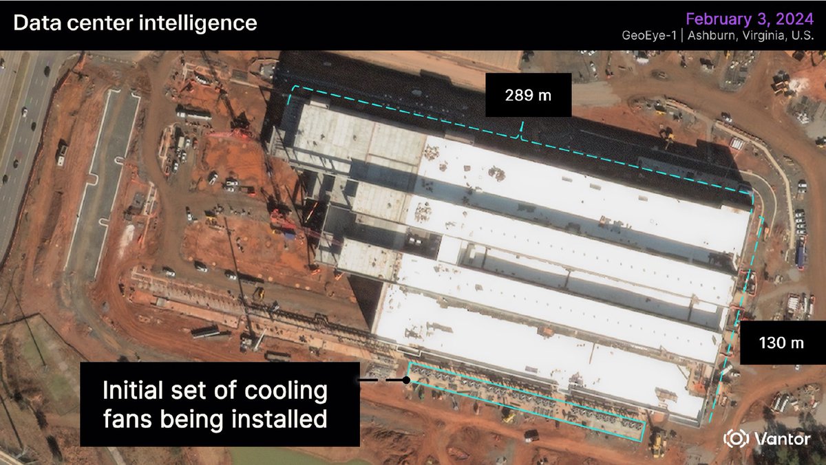
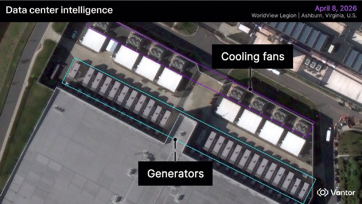
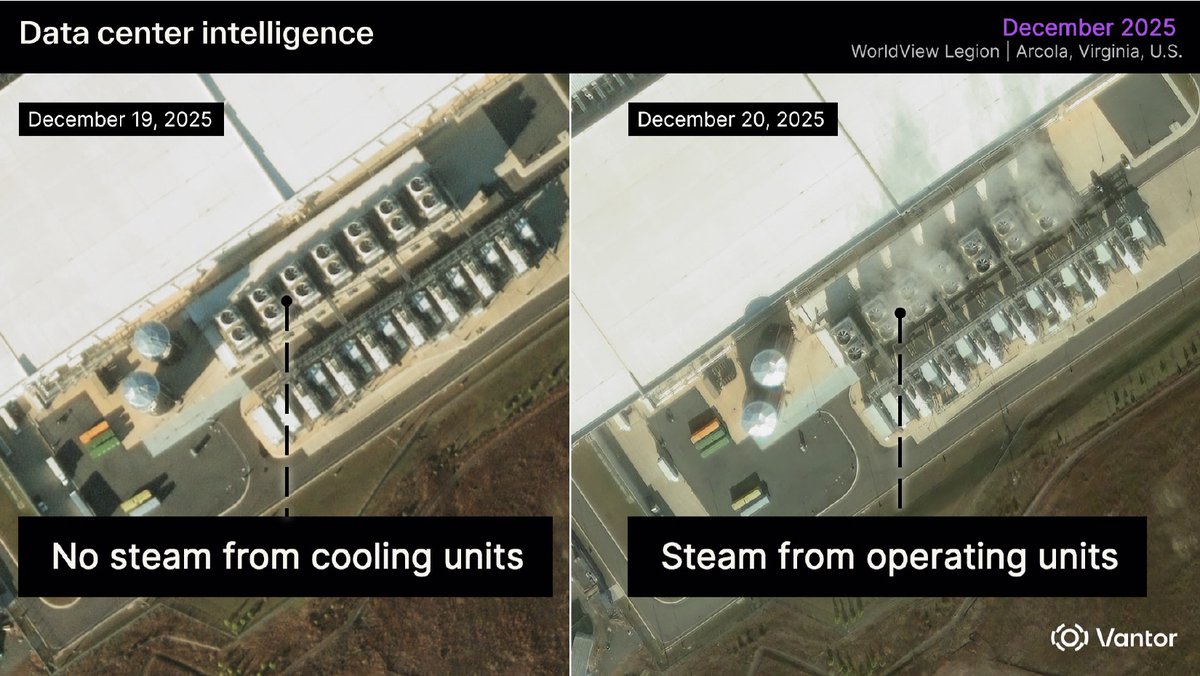
Data center growth is moving fast, and bringing them online takes capital, construction coordination, power capacity, and more.
Physical changes on the ground can reveal how quickly a site is advancing, what capacity may be coming online, and whether development activity aligns with an investment thesis. The strongest market signals are not always found in public reporting.
With Vantor’s spatial intelligence, finance teams can monitor signals such as building scale, generator and cooling infrastructure installation, equipment placement, and visible operational activity across regions or portfolios.
That clearer view at a regular cadence can help investors and analysts track market movement, assess development risk, and identify emerging capacity before it is widely reported.
Read the full blog to learn how spatial intelligence can support data center market intelligence: vantor.com/blog/data-center-…
1
10
45
8,099
Jun 2
This is a spent Chinese Long March 3B rocket body, imaged by a Vantor WorldView Legion satellite from 88 km away.
The image quality is not simply about range. It reflects the strength of Vantor’s advanced WorldView constellation and high-performance imaging hardware, which enable detailed observation of objects in orbit.
It’s a powerful example of Vantor’s NEI tasking through our WorldView Space product line: using high-resolution satellites to look out into space and capture detailed imagery of objects in orbit.
Why does that matter? Most tracking systems can show where an object is. WorldView Space NEI helps show what it is, its structure, orientation, condition, and potential risk. It can also support Movement Analysis, helping operators understand whether an object is intact, tumbling, spinning, or otherwise changing behavior over time.
That level of detail is especially important for large rocket bodies like this one. They are big, long-lived debris objects that share orbits with critical infrastructure, including communications, Earth observation, weather, science, and national security satellites. A single collision involving an intact rocket stage can create thousands of new fragments, increasing risk across already crowded orbital regions.
As launch activity accelerates, we need to understand not just where objects are in space, but what they are, how they are moving, and how they may behave over time.
11
169
925
102,255
Jun 1
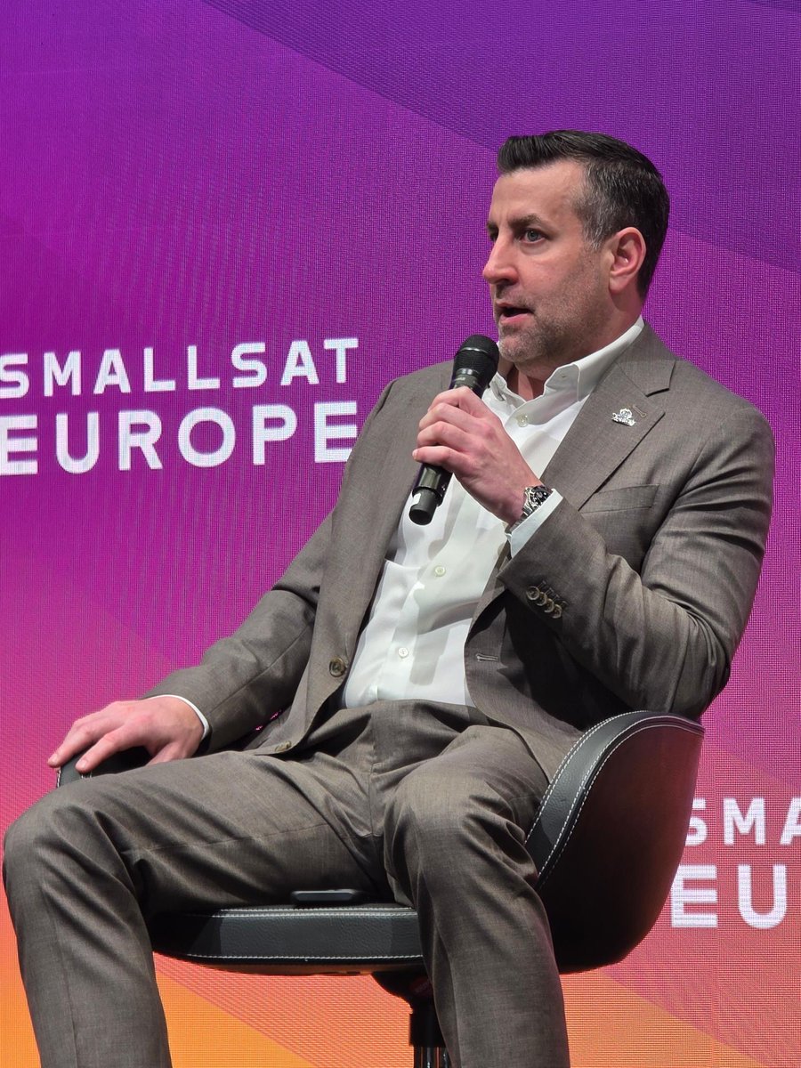
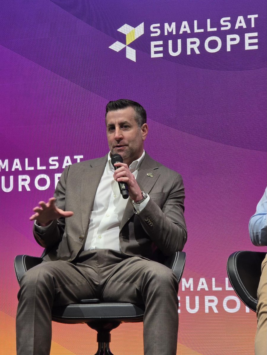
The future of geospatial intelligence is not defined by a single sensor — it is defined by how multiple sources of intelligence come together.
At SmallSat Europe, Matthew Jenkins joined the panel “The Multi-Physics EO Stack: Fusing SAR, Thermal, and Hyperspectral,” alongside industry leaders to discuss how advanced geospatial intelligence is evolving through multi-source data fusion, common tasking, and AI-enabled analytics.
As highlighted in a recent @SatNewsEvents article, “The pixel war is over. The integration war is what comes next,” the competitive frontier in Earth observation is moving beyond imagery alone. The next phase is about delivering fused intelligence into customer workflows — combining optical, SAR, thermal, hyperspectral, and other data sources to help users move faster from question to answer.
Great discussion from Matt and the panel on where the EO industry is headed next.
Read the full SatNews article here:
satnews.com/2026/05/28/the-p…

1
4
7
3,738
May 29
The future of spatial intelligence is being built now — and Vantor is looking for the talent to help lead it.
Connect with our recruiting team at the @ClearanceJobs Polygraph Only Virtual Hiring Event on June 3 and discover opportunities to work on mission-driven technology that makes an impact. We’re hiring software engineers, full stack developers, data analysts and software developers who are ready to solve complex challenges and push boundaries.
At Vantor, we’re seeking curious thinkers, technical innovators and driven professionals who want to help build what’s next.
If you're ready to make an impact, we want to meet you.
Register today: about.clearancejobs.com/cand…
1
1
8
3,205
May 28
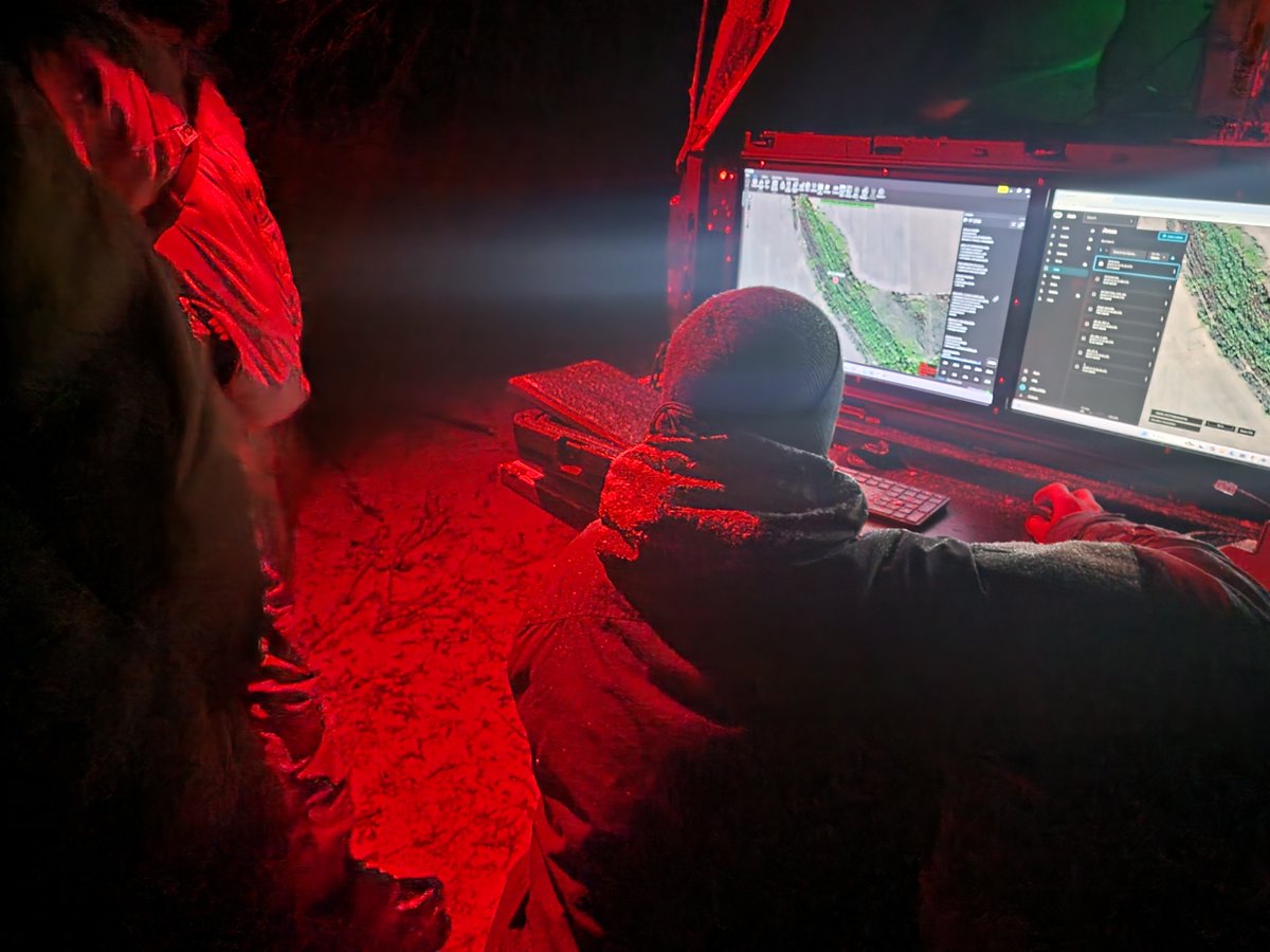
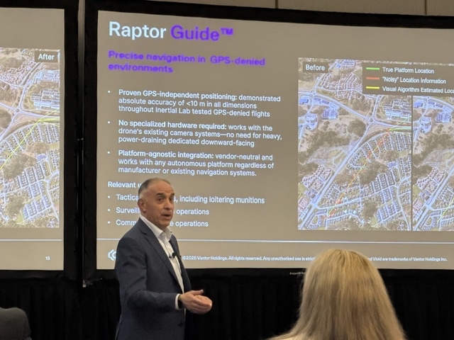
Raptor was built for the realities operators face now: contested signals, complex terrain, and fast-moving decisions that depend on accurate geospatial data.
In May, our team brought that message to five industry events: SOF Week in Tampa, GXP360 Professional Exchange in San Diego, XPONENTIAL in Detroit, DAIMEX Baltic 2026 in Lithuania, and the Loitering Munitions Systems Summit in Virginia.
The discussions varied by audience, but across booths, briefings, and customer discussions, two themes stood out:
1. The core need is consistent: teams, especially government customers, want more reliable ways to navigate, interpret, and act on aerial data when GPS is unreliable.
2. Autonomy is on the rise. Maintaining communications over longer ranges is becoming increasingly untenable. Systems must be able to perform their missions on their own.
At GXP360, one point was especially clear: The GXP community is highly dedicated, technically engaged, and passionate about geospatial intelligence. Attendees quickly saw how Raptor Sync can support full-motion video processing by bringing Raptor’s geospatial alignment capabilities into the GXP software suite.
For the Vantor team, the past month was a valuable reminder: the market is not looking for more complexity. It is looking for practical, flexible software that helps turn sensor data into trusted location insight.
Learn how Raptor supports that work: go.vantor.com/autonomy-witho…

2
11
3,335
May 27
True sovereign intelligence capability isn’t defined by how much space-based data you collect. It’s defined by whether you can turn that data into a consistent operational picture fast enough to matter.
Today, many national strategies are focused on expanding inputs: satellites, sensors, AI models. All essential. But sovereignty doesn’t end at collection.
It depends on what happens next:
• Can you align multi-source intelligence into one ground truth, even as you bring on new sensors?
• Can you maintain that ground truth as conditions change?
• Can you deliver it into operations, integrated across your ecosystem, without rebuilding it every time?
That’s the difference between owning data and controlling outcomes.
The nations moving fastest aren’t replacing existing investments. They’re connecting them around a shared, continuously maintained ground truth.
Vantor’s Elie Tabchouri, EVP and GM of our International Government business, explores what this shift means — and what it actually takes to achieve sovereign intelligence — in his latest blog:
vantor.com/blog/sovereignty-…
2
3
13
3,664
May 25
This Memorial Day, we honor the memory, sacrifice, and enduring legacy of the men and women who gave their lives in service to the United States.
From the historic heights of Mount Suribachi on Iwo Jima to memorial sites around the world, preserving these places helps ensure their stories are never forgotten.
We believe conserving history helps future generations better understand the courage and sacrifice that shaped it.
Today, we pause to remember the heroes who served and sacrificed. 🇺🇸
1
5
19
3,576
May 22
The GIS community within the energy industry continues to push for geospatial workflows that are more connected, current, and operationally useful. That theme came through clearly at this week’s Esri Energy Resources GIS Conference in Houston.
Thank you to the @Esri team for hosting a productive event, and to our customers, partners, and new connections who joined us for conversations throughout the week.
Here's three other takeaways from the week:
🌐 Teams are prioritizing georegistration across their data stacks to enable more efficient analysis. We appreciated the opportunity to share how Tensorglobe can support this type of work as organizations look to align and analyze complex geospatial data more effectively.
🛰 Customers are eager to explore Vantor Hub and understand how improved refresh rates from our expanded constellation can support their operations.
✨ In-person connection still matters, and The Grove was a great setting to continue the conversations after hours.
Missed us at the conference? Connect with us online: vantor.com/industries/commer…

4
18
3,868
May 21
In a few minutes, @SpaceX is set to launch Starship from Boca Chica, Texas, continuing one of the most ambitious campaigns in modern spaceflight. At 4:52 p.m. CDT—barely an hour ago—Vantor captured this high-resolution image of Starship on the launchpad with one of our WorldView Legion satellites.
Wishing SpaceX lots of luck for today’s launch. At Vantor, we’re continuing to watch the future of space from space.
6
51
401
15,387
May 20
Accuracy is more than a technical detail. It’s what makes geospatial data usable in the real world.
When imagery is accurate, everything built on top of it becomes more reliable: maps align more cleanly, mosaics look sharper, and roads, bridges, and overpasses appear where they should, without distortion. Accuracy also makes it easier to combine different data sources into one trusted view of the world. That matters for applications like autonomous navigation, infrastructure monitoring, and AI/ML analysis, where even small errors can lead to missed insights or false detections.
Vantor’s constellation collects the most accurate commercial satellite imagery available. Every pixel is within 5 m of its real-world location. Our 3D imagery offers even greater precision, with accuracy down to 3 m in all dimensions.
The better the accuracy, the better the decisions. How accurate is the intelligence you rely on?
1
6
28
3,577
May 19
We’re here at #SOFWeek2026 in Tampa to connect with the global special operations community and our partners helping deliver advanced real-time intelligence capabilities to the warfighter.
This week, we’re showcasing Vantor’s Tensorglobe-powered 3D capabilities, which deliver an up-to-date view of the operational terrain directly to warfighters and the autonomous systems that support them. Our highly accurate 3D maps—updated within hours of a new satellite pass—help operators better understand the mission environment as it truly exists. This enables more effective elevation and line-of-sight analysis, as well as enhanced situational awareness for mission planning and live tactical operations.
As a result, every warfighter and machine operates from the same precision-aligned operational picture, helping teams move faster, plan with greater clarity, and operate with confidence in complex and contested environments.
Stop by Booth #307 to meet the team, see the capability in action, and learn how Vantor is delivering mission-ready geospatial intelligence where it matters most.


1
13
3,400