
8,907 Photos and videos


WBKO First Alert Weather retweeted

What a lovely day! Enjoy the cooler and pleasant weather this evening, hotter temperatures and storms return midweek.
1
2
337

Severe Thunderstorm Warning for McLean, Muhlenberg, Hopkins Co. until Jun 13 4:45PM. Check WBKO.com, WBKO-TV, and WBKO social media for more details. @WBKOWeather @wbkotv #wbkowx #kywx
2
1
900
WBKO First Alert Weather retweeted
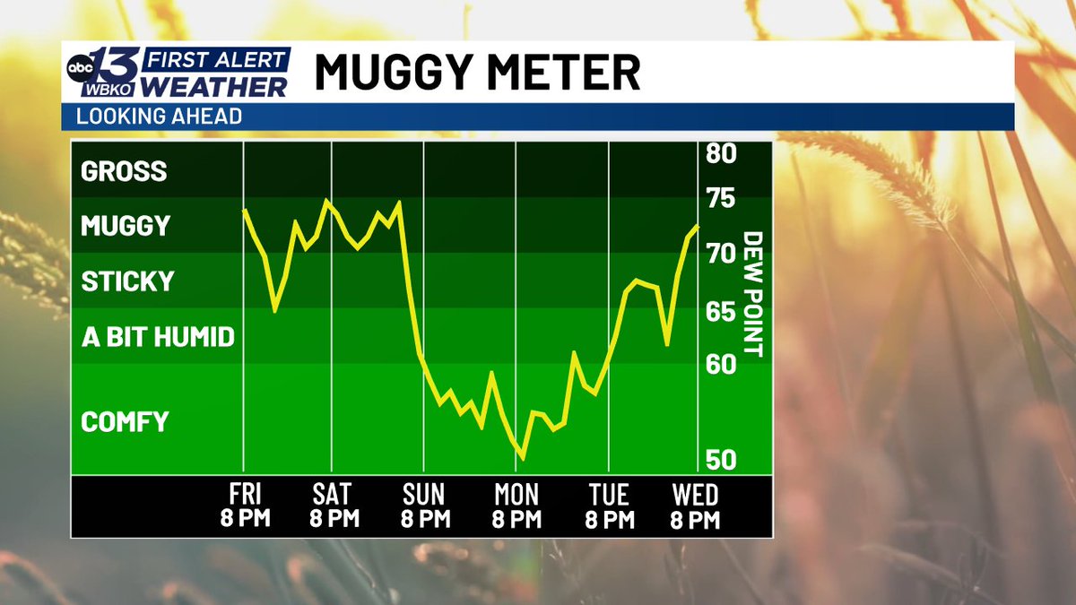
Muggy conditions continue for the rest of today and into tomorrow, but we've got a break from the heat and humidity to start next week!
1
421
WBKO First Alert Weather retweeted
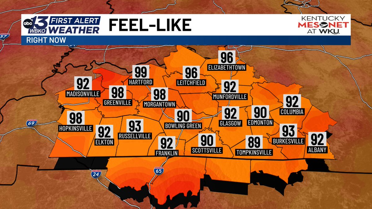
It is feeling HOT outside! Make sure to drink plenty of water and take breaks in the shade as heat index values reach close to or around 100 degrees this afternoon.

1
1
565
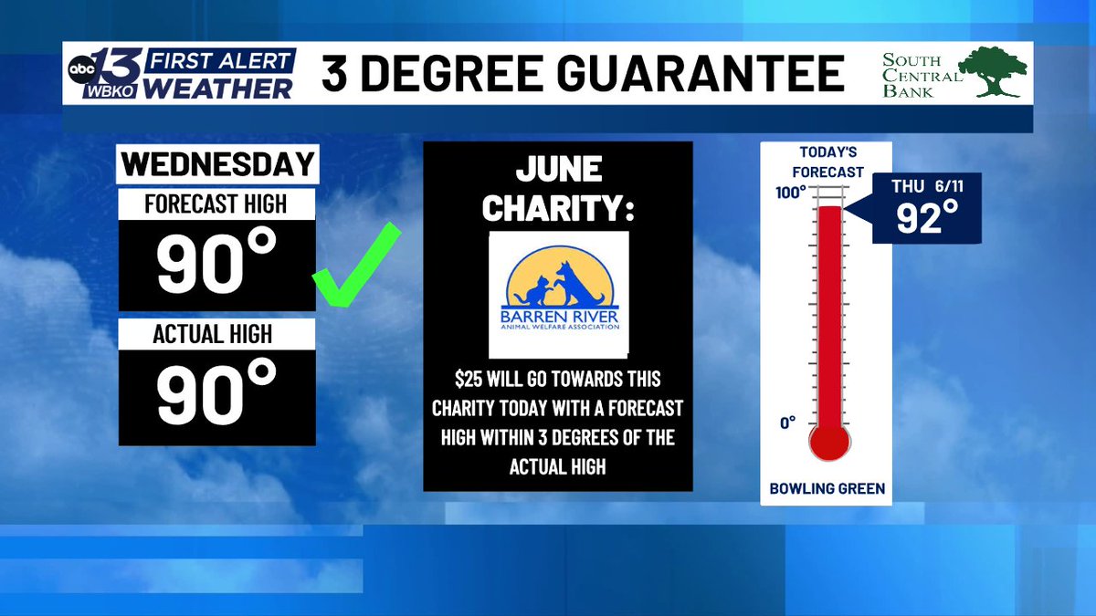
We've secured another donation to this month's 3DG guarantee! Today things continue to heat up with more muggy weather and a high of 92.
1
653
WBKO First Alert Weather retweeted
Although air temperatures are in the upper 80s for most across south-central Kentucky, heat index values are reaching closer to 100 degrees due to humid conditions. Make sure to drink plenty of water and protect yourself from the heat today.
1
508
Flash Flood Warning for Logan Co. until Jun 09 7:45PM. Flooding is occurring or is imminent! Check WBKO.com and WBKO-TV for more details. @WBKOWeather @DavidWolter1 @wbkotv #wbkowx #kywx
3
5
942
RADAR UPDATE (4:39 PM): Rain and thunderstorms are exiting the region. Another round of rain and thunderstorms are possible tonight.
1
1
521
Flash Flood Warning for Warren Co. until Jun 09 6:15PM. Flooding is occurring or is imminent! Check WBKO.com and WBKO-TV for more details. @WBKOWeather @DavidWolter1 @wbkotv #wbkowx #kywx
3
2
834
Severe Thunderstorm Warning for Taylor, Green Co. until Jun 09 1:45PM. Check WBKO.com, WBKO-TV, and WBKO social media for more details. @WBKOWeather @wbkotv #wbkowx #kywx
2
1
516
Flash Flood Warning for Larue, Taylor Co. until Jun 09 1:15PM. Flooding is occurring or is imminent! Check WBKO.com and WBKO-TV for more details. @WBKOWeather @DavidWolter1 @wbkotv #wbkowx #kywx
4
4
680
Flash Flood Warning for Hardin Co. until Jun 09 12:30PM. Flooding is occurring or is imminent! Check WBKO.com and WBKO-TV for more details. @WBKOWeather @DavidWolter1 @wbkotv #wbkowx #kywx
2
2
640
Flash Flood Warning for Green, Hart, Taylor Co. until Jun 09 10:15AM. Flooding is occurring or is imminent! Check WBKO.com and WBKO-TV for more details. @WBKOWeather @DavidWolter1 @wbkotv #wbkowx #kywx
2
2
760
WBKO First Alert Weather retweeted

The heat and humidity is going to make it feel like the middle 90s today, but closer to 100 Wednesday afternoon!

2
843
WBKO First Alert Weather retweeted
RADAR UPDATE (4:07 AM): Heavy rainfall is leading to some flash flooding this morning, especially over northern parts of the area. Additional showers and storms are expected to develop during the day. The Flood Watch continues through this evening.
2
1
957
Flash Flood Warning for Grayson, Breckinridge, Hardin, Hart Co. until Jun 09 7:45AM. Flooding is occurring or is imminent! Check WBKO.com and WBKO-TV for more details. @WBKOWeather @DavidWolter1 @wbkotv #wbkowx #kywx
2
1
747
Flash Flood Warning for Butler, Grayson, Breckinridge, Edmonson, Ohio Co. until Jun 09 6:30AM. Flooding is occurring or is imminent! Check WBKO.com and WBKO-TV for more details. @WBKOWeather @DavidWolter1 @wbkotv #wbkowx #kywx
2
1
660
Flash Flood Warning for Butler Co. until Jun 09 5:00AM. Flooding is occurring or is imminent! Check WBKO.com and WBKO-TV for more details. @WBKOWeather @DavidWolter1 @wbkotv #wbkowx #kywx
2
1
654
WBKO First Alert Weather retweeted
RADAR UPDATE (11:05 P.M.): Rain showers and thunderstorms continue through the area. Some gusty winds up to 40 mph are possible as well as heavy downpours.
1
541
TRACKING: A severe thunderstorm warning has been issued for Christian and Todd counties. Winds up to 60 mph are possible as well as hail. We will continue to bring updates as this storm makes its way into the area.
2
807