
WCCO-TV Chief Meteorologist
Joined September 2009
- Tweets 14,021
- Following 587
- Followers 14,935
- Likes 16,718
4,520 Photos and videos


Chris Shaffer retweeted

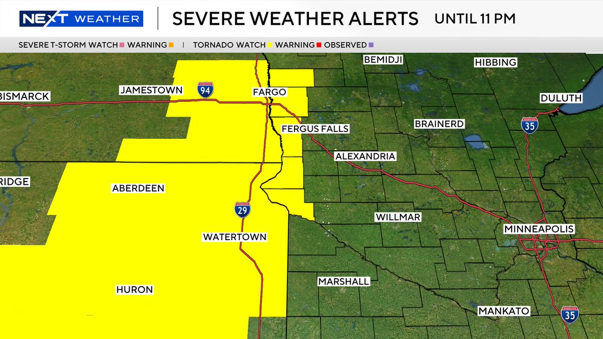
⚠️ SEVERE T-STORM WARNING for Lyon county until 6/15 11:15PM. 1" hail and/or 60 mph winds are possible. More: wcco.com/weather #mnwx #wiwx
2
1
1,277
Chris Shaffer retweeted
⚠️ SEVERE T-STORM WARNING for Pine, Aitkin county until 6/15 7:30PM. 1" hail and/or 60 mph winds are possible. More: wcco.com/weather #mnwx #wiwx
2
2
2,999
Chris Shaffer retweeted
⚠️ SEVERE T-STORM WARNING for Isanti, Chisago, Mille Lacs, Kanabec county until 6/15 7:30PM. 1" hail and/or 60 mph winds are possible. More: wcco.com/weather #mnwx #wiwx
2
3
2,875

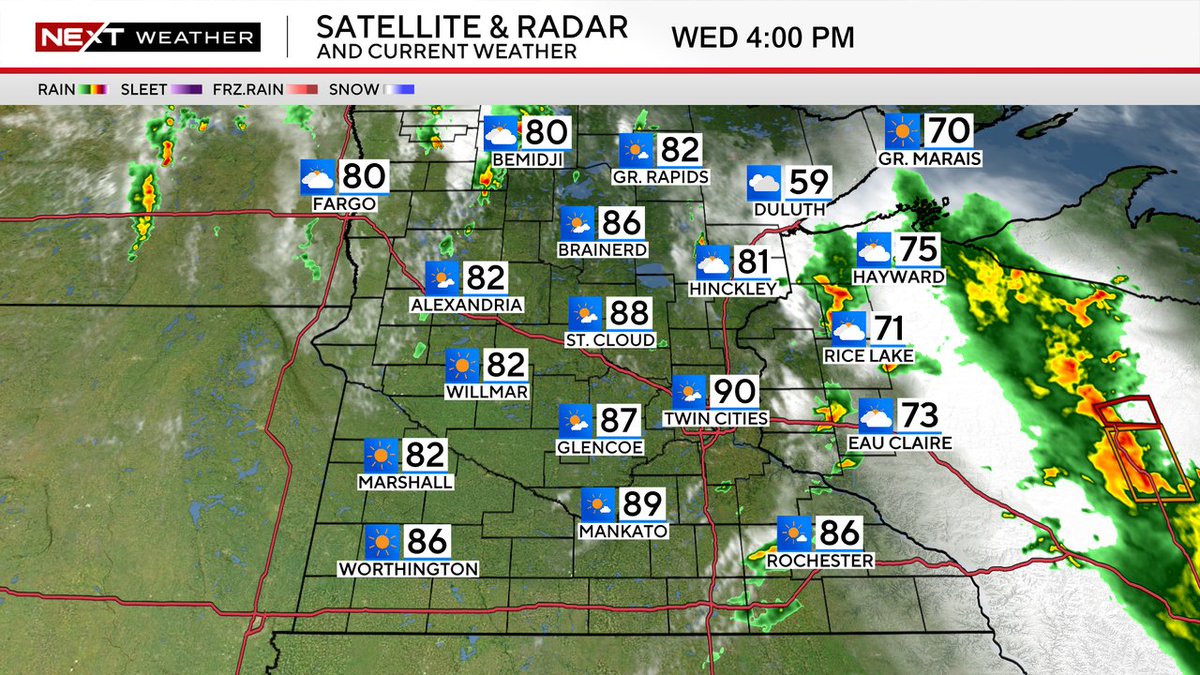
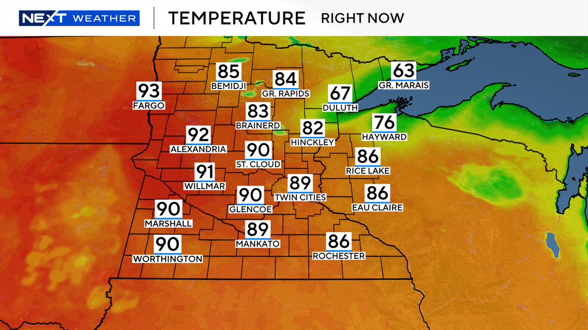
For planning purposes...we do have some rain coming that will be a part of your evening and night plans. A few thunderstorms are in the mix, but they will weaken into the night.
4
2,100
Chris Shaffer retweeted
⚠️ SEVERE T-STORM WARNING for La Crosse, Houston, Winona county until 6/11 12:00PM. 1" hail and/or 60 mph winds are possible. More: wcco.com/weather #mnwx #wiwx
2
5
2,423
Chris Shaffer retweeted
⚠️ SEVERE T-STORM WARNING for Trempealeau, Winona, Buffalo county until 6/10 6:30PM. 1" hail and/or 60 mph winds are possible. More: wcco.com/weather #mnwx #wiwx
1
2
3
1,962
Chris Shaffer retweeted
⚠️ TORNADO WARNING for Trempealeau, Buffalo county until 6/10 6:15PM. TAKE COVER NOW in a basement, interior room or closet on the lowest level of your home. More: wcco.com/weather #mnwx #wiwx
2
5
3,578
Chris Shaffer retweeted
⚠️ SEVERE T-STORM WARNING for Fillmore, Winona, Olmsted county until 6/10 6:30PM. Damaging 1.75" hail and/or 70 mph winds are possible. Seek sturdy shelter. wcco.com/weather #mnwx #wiwx
2
1
1,815
Chris Shaffer retweeted
⚠️ SEVERE T-STORM WARNING for Chisago county until 6/10 6:15PM. 1" hail and/or 60 mph winds are possible. More: wcco.com/weather #mnwx #wiwx
2
2,494
Chris Shaffer retweeted
⚠️ SEVERE T-STORM WARNING for Trempealeau, Buffalo county until 6/10 6:15PM. 1" hail and/or 60 mph winds are possible. More: wcco.com/weather #mnwx #wiwx
2
2,018
Chris Shaffer retweeted
⚠️ SEVERE T-STORM WARNING for Morrison county until 6/10 6:15PM. 1" hail and/or 60 mph winds are possible. More: wcco.com/weather #mnwx #wiwx
2
2
1,930
Chris Shaffer retweeted
⚠️ SEVERE T-STORM WARNING for Cass, Crow Wing, Itasca county until 6/10 6:15PM. 1" hail and/or 60 mph winds are possible. More: wcco.com/weather #mnwx #wiwx
2
1
1,605
Chris Shaffer retweeted
⚠️ SEVERE T-STORM WARNING for St. Louis, Douglas, Carlton county until 6/10 6:00PM. 1" hail and/or 60 mph winds are possible. More: wcco.com/weather #mnwx #wiwx
2
1,541
Chris Shaffer retweeted
⚠️ SEVERE T-STORM WARNING for Winona, Wabasha, Olmsted, Buffalo county until 6/10 6:00PM. 1" hail and/or 60 mph winds are possible. More: wcco.com/weather #mnwx #wiwx
2
1
1,792
Chris Shaffer retweeted
⚠️ SEVERE T-STORM WARNING for Itasca, Koochiching county until 6/10 5:45PM. 1" hail and/or 60 mph winds are possible. More: wcco.com/weather #mnwx #wiwx
2
1
1,529
Chris Shaffer retweeted
⚠️ SEVERE T-STORM WARNING for Todd, Stearns, Douglas county until 6/10 5:45PM. Damaging 1.75" hail and/or 70 mph winds are possible. Seek sturdy shelter. wcco.com/weather #mnwx #wiwx
2
1
1,686
Chris Shaffer retweeted
⚠️ SEVERE T-STORM WARNING for Pepin county until 6/10 5:30PM. 1" hail and/or 60 mph winds are possible. More: wcco.com/weather #mnwx #wiwx
2
3
2,875
Chris Shaffer retweeted
⚠️ SEVERE T-STORM WARNING for Buffalo county until 6/10 5:30PM. 1" hail and/or 60 mph winds are possible. More: wcco.com/weather #mnwx #wiwx
2
1
1,448
Chris Shaffer retweeted
⚠️ SEVERE T-STORM WARNING for Olmsted, Wabasha county until 6/10 5:15PM. 1" hail and/or 60 mph winds are possible. More: wcco.com/weather #mnwx #wiwx
2
2
1,919