
Joined January 2015
- Tweets 10,788
- Following 152
- Followers 1,517
- Likes 48
8,269 Photos and videos


Strong, damaging winds, large hail, and a few tornadoes are possible as a cold front moves across the Tri-States tomorrow from 3-7pm. Stick with WGEM News and have a way to receive warnings if any get issued tomorrow. wgem.com/weather #severe #forecast
2
1
786
An area of interest, Invest 90-L, is trying to get its act together near the Texas Gulf coast. If it is able to move over the western Gulf over the next day or so, it could develop and become a weak topical depression or tropical storm. If it gets a name, it would be Arthur.
1
136
Watch for a few showers early today as a shortwave trough moves through. Following drier conditions later on, clouds will build back in tonight. Tomorrow, we're in First Alert for the risk of severe storms from 3-7pm. wgem.com/weather #severe #forecast
1
128
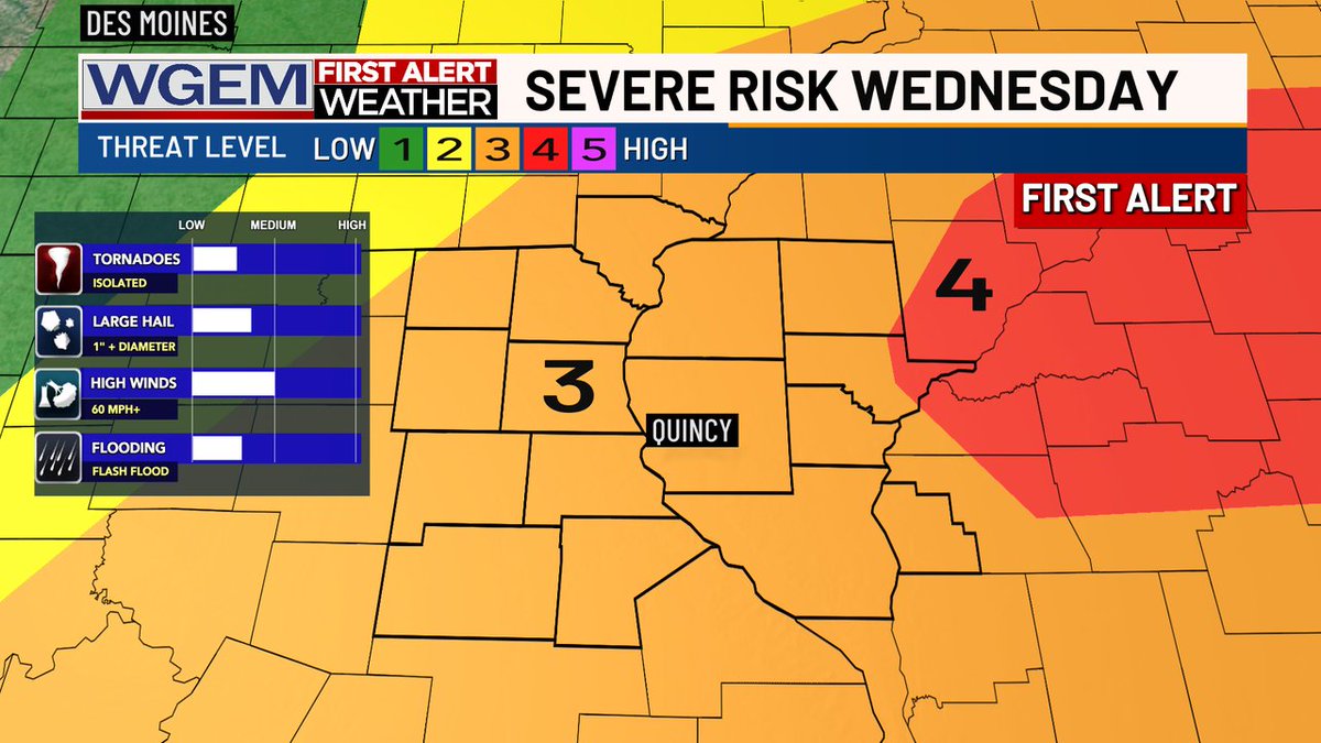
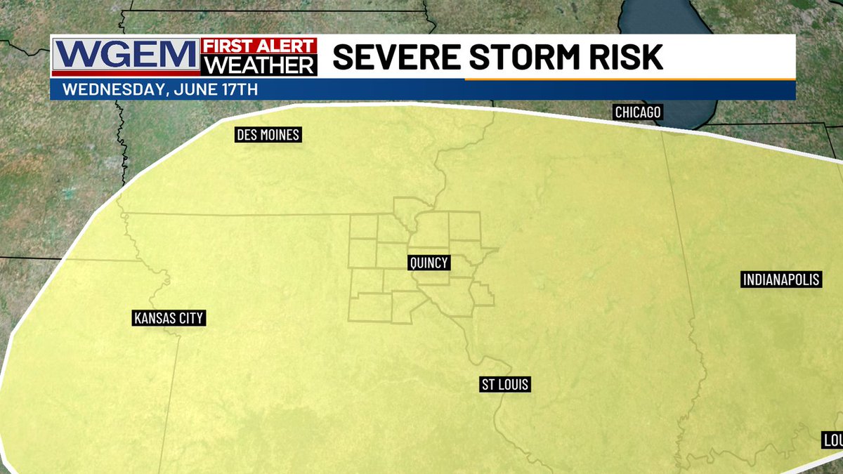
FIRST ALERT: Strong to severe storms are possible from 3-7pm Wednesday afternoon and evening, putting us in a level 3 of 5 severe risk. Stick with WGEM News to see what tomorrow's Futurecast looks like. wgem.com/weather #severe #storms #forecast
1
1
221
We have a level 3 of 5 severe storm threat on Wednesday, primarily for storms to turn strong to severe during the afternoon and evening. Download the WGEM First Alert Weather app now to stay ahead of Wednesday's severe storm threat. wgem.com/weather
1
1
190
Heads up if you plan on driving across the Bayview Bridge or Memorial Bridge early this afternoon. Fire crews are responding to a massive fire at Haymaker's gas station in West Quincy, Missouri early this afternoon. #fire
2
2
223
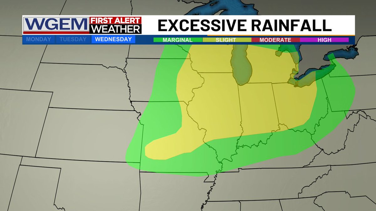
Along with a threat for severe storms on Wednesday comes a risk for excessive rainfall. Find out how much rain to expect on WGEM News Today and at wgem.com/weather #severe #storms #rain #forecast
1
1
216
While high-pressure is in place today, a weak shortwave trough looks to bring a stray shower or two to the area tomorrow morning. By Wednesday, we will be in First Alert for the risk of severe storms throughout the day. wgem.com/weather #severe #forecast
1
175
High-pressure moving into our area today will keep conditions considerably cooler and drier than yesterday, perfect for outdoor activities. Showers and thunderstorms return by midweek with a threat for severe weather on Wednesday. wgem.com/weather #severe
1
172
As a shortwave trough moves through on Wednesday, scattered showers and thunderstorms may turn severe during the afternoon and evening. Be sure to stick with WGEM News for the latest updates as we get closer to Wednesday. wgem.com/weather #severe #forecast
1
1
155
While we did trend stormier than expected earlier today, conditions will turn drier late this afternoon. That said, expect more storms to return to the picture after sunset, some of which may bring hail and gusty winds. wgem.com/weather #storms #forecast
1
192
After scattered showers and thunderstorms roll out of our southern half of the Tri-States, we'll see skies clear a bit into the afternoon with temperatures in the low-mid 80s. Dew points will rise into the low 70s before a cold front swoops through.
1
1
245
Highs will reach back into the mid 80s for most Saturday, with dew points into the low 70s thanks to winds out of the southwest. As a cold front approaches, scattered showers and storms will form and push through the Tri-States beginning late PM.
1
1
194
We're still tracking some more scattered showers and storms entering the Tri-States Saturday evening into night along a cold front. Damaging wind gusts will be out main threat of severe weather.
1
1
138
Our severe risk has slightly lowered across our southern tier of the Tri-States tomorrow evening. We look for storms to move from northwest to southeast around 6pm-11pm, so have a way to get warnings tomorrow evening. wgem.com/weather #severe #forecast
1
1
135
Our severe risk just lowered from Quincy on southward for tomorrow evening. We are still in a level 2 of 5 risk for the chance for thunderstorms to turn strong to severe from early evening through shortly before midnight (6pm-11pm). wgem.com/weather #severe #forecast

1
1
103
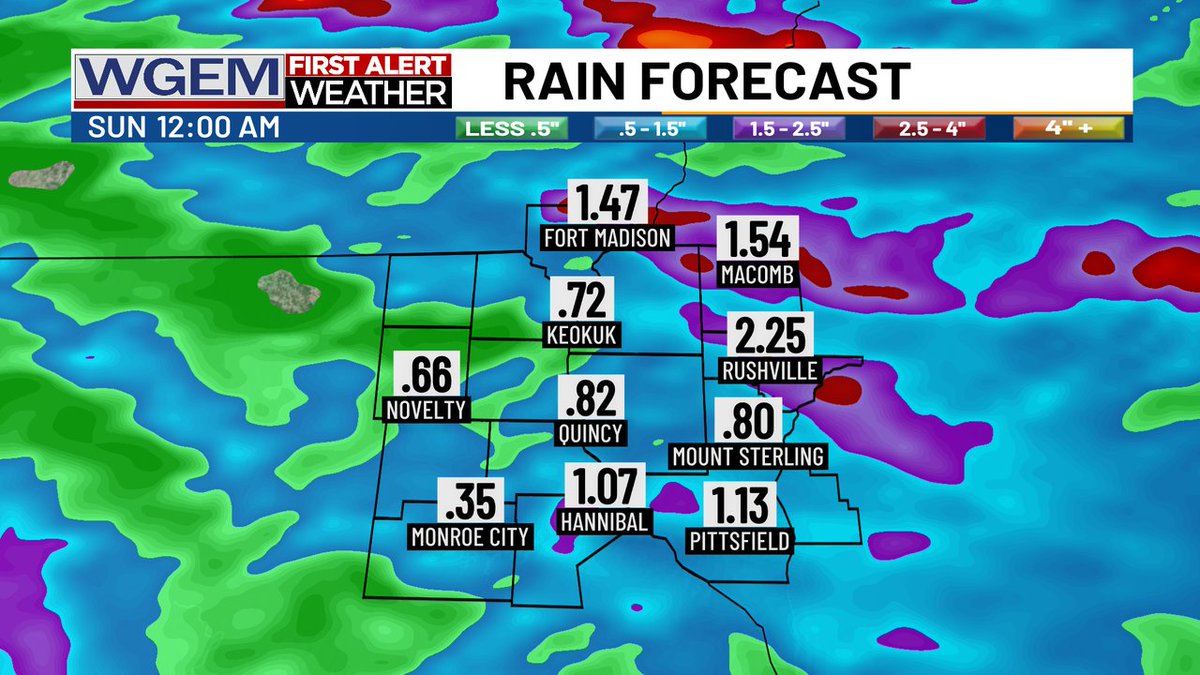
As more strong to severe storms are possible tomorrow evening, many spots can expect another half of an inch to 1 inch of rain. However, a few locations may see 1" to 2" of rain by midnight Sunday morning. wgem.com/weather #rain #severe #forecast
1
1
135
Mother Nature will treat us to a dry end of the work week alongside some comfy conditions. While outdoor activities look fine though mid-afternoon tomorrow, we go into First Alert for the risk of severe weather tomorrow evening. wgem.com/weather #severe
1
1
144
We are in a level 3 and 4 of 5 risk for severe storms to arrive later today. The onset arrives in our western tier near 3pm, approaches the Mississippi River around 6pm, and exits our eastern communities just before sunset. wgem.com/weather #severe
1
1
189