
WNK is an official Weather-Ready-Nation Ambassador with the National Weather Service. Over 200,000 followers across platforms! Follow for Kentucky Info!
Joined January 2022
- Tweets 6,948
- Following 32
- Followers 5,247
- Likes 2,051
4,830 Photos and videos


Pinned Tweet

😳 ANNOUNCEMENT:
- Weather Now Kentucky has been designated as an Official Weather-Ready Nation Ambassador with the National Weather Service. We have the trust of the NWS, hopefully we can continue to earn yours. Thank you for your support over the years. An incredibly proud day! - George ❤️
6
9
110
22,078
❄👀: Cooler than average air is heading into Kentucky. This will obviously bring more comfortable conditions, but... Cold air smashing in during summer... You do the math. Cold/dry Warm/humid= More aggressive storms. We're watching!
3
18
521
The last time I saw this level of kinematics thermodynamics, was December 10, 2021.
I am in no way saying the result will be the same, but Missouri and Illinois as well as Indiana and Kentucky will need to be on alert, Wednesday.
2
16
851
Weather Now Kentucky retweeted

Need to know how to enable our Split Screen feature? Here's a quick tutorial for you!
- Clarification: It's up to 3 on mobile, 4 on desktop (pro & plus users).

🚨 OBSERVED Tornado just North of Punxsutawney, Pennsylvania tonight. This is still active as it is now heading toward Goshen.
-Here's what it looked like at its "peak" on radar. With Weatherwise Pro, you can have up to 4 panels at the same time. This allows you to really see the details of a dangerous storm.

1
3
23
2,236
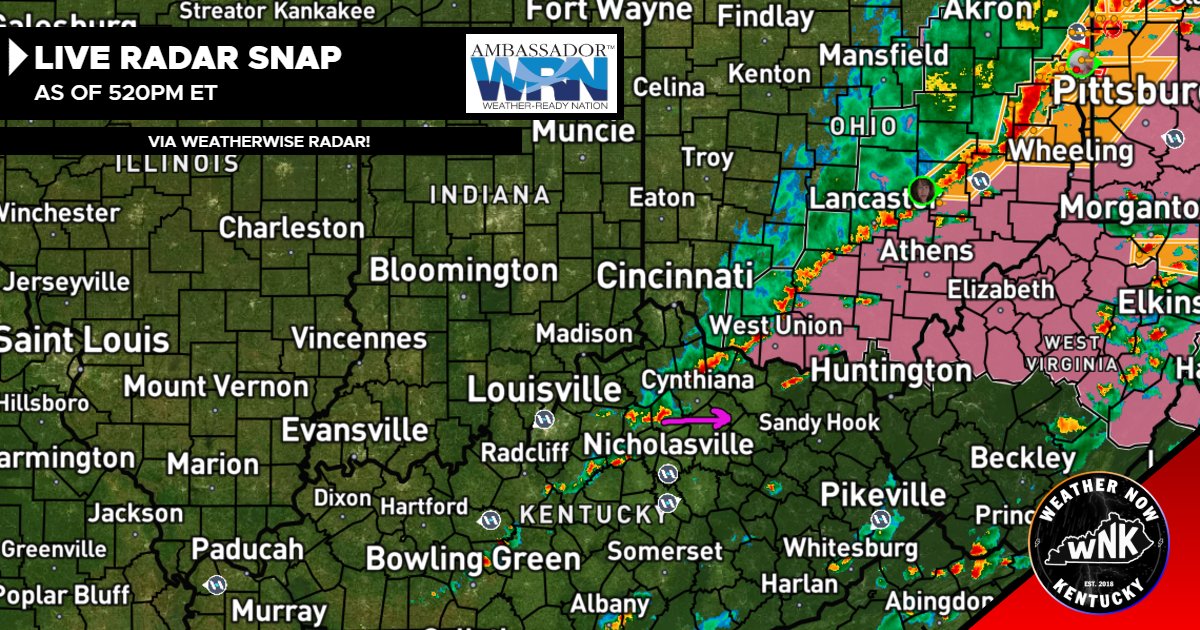
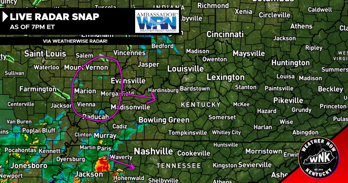
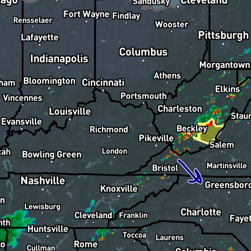
5:20pm ET, Radar Check:
- Once again, the main action is just outside of Kentucky. There is still some energy left in Eastern Kentucky to support a couple of windy thunderstorms... It's clear, in 2026, storms come to die in Kentucky. Not a bad thing, but some of you still need some rain, believe it or not. - George
1
356
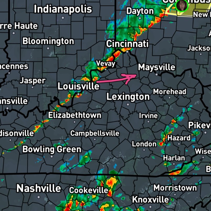
4:05pm ET:
- This thin line has stayed calm so far. It should pick up in intensity as it heads more East. Still, only damaging winds remains as the main concern. Lookout for a quick burst of moderate rainfall, few rumbles of thunder and some lightning. -George
1
1
4
460
Weather Now Kentucky retweeted
How to turn on our free NWS Push Alerts as well as Y'all Watches, from Ryan Hall's team inside of the Weatherwise app.
Now you don't have to stare at the radar, we'll alert you when it's serious! Stay Weather wise, with the Weatherwise app.
1
7
35
3,782
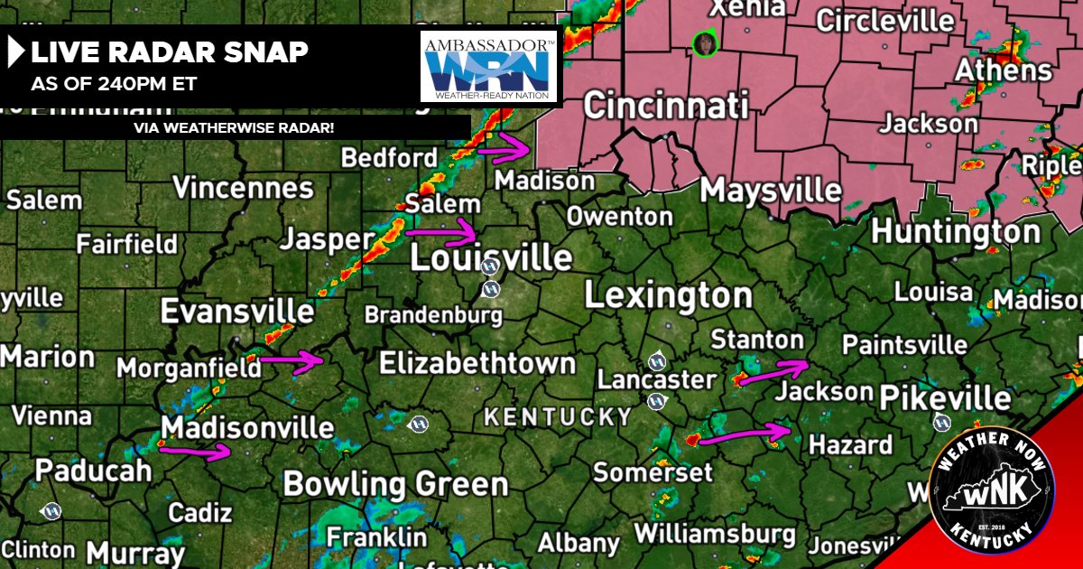
2:40pm ET, RADAR CHECK:
- A skinny but mean (just like me) line of storms is pushing East. There is a Severe T'Storm Watch for the Northern 3 counties toward Ohio, mainly for the Damaging wind potential.
- I don't *think* that will be expanded more into Kentucky, but it isn't impossible.
- In Eastern Kentucky, a few isolated cells have popped up... Very minimal threat with these, but look out for some heavy rains and gusty winds up to 50mph. - George
1
3
7
654
1:25pm ET:
- Here's a developing line that we'll need to keep a close eye on for Northern Kentucky. We still have a couple of hours until the severe window opens, we'll keep you posted. The primary risk would be damaging winds. - George
2
5
430
🚨: I'm going to shoot you straight. Wednesday has the opportunity to produce the most significant severe weather of the year, in the United States. Thankfully, the biggest threat is outside of Kentucky, according to the latest data. The threat will still exist inside of our state (at least the Northern half). As we get closer, I will break this down more and more each day. - George
9
32
2,251
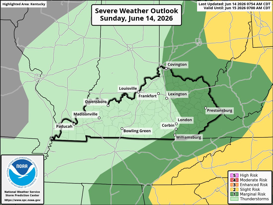
⛈️: Level 1/5 (Marginal) Severe risk in East Kentucky today. This is strictly for the threat of brief damaging winds and small hail between 3-9pm ET.
- Some storms may pop, then form into a line and track East, in Central-Eastern Kentucky. Once they form that line and mature, they'll carry that brief severe risk in East Kentucky. A very low-end threat. - George
1
5
486
🤞🏻: I've been watching radar and noting the latest trends. At this time, I don't think there will be much rain activity overnight, let alone a severe threat. Every storm that's firing in or near Kentucky is growing, but then hitting a cap, and dying out. This tells us our environment is stable. I will let you know if that changes. For now, sleep easy, Kentucky! - George
1
10
1,141
⛈️: Summertime is easily the hardest season to forecast. In Kentucky summers, our storm type typically switches to what we call a Meso-convective system. These are often unpredictable, slow moving and quite dangerous. On the flip side, they fizzle out rapidly too. We've got several of these storm chances lying ahead. Expect last minute updates and often posting. Be sure to check back regularly! - George
4
13
866
7pm ET:
~ We. Are. Cursed. The previous cluster faded on our side and became Southern side dominated. There *could* be another cluster that develops in the circled region. But, ya' know, Kentucky... - George
2
1
5
790
4:15pm ET:
- Keeping an eye on this growing complex of storms entering Western Kentucky. This line may mature and produce a damaging wind threat over the next couple hours. The storms will eventually grow and push through much of Kentucky but the severe threat will diminish the more it pushes East. - George
1
7
635
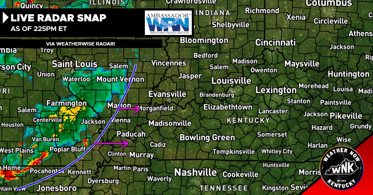
2:25pm ET, RADAR CHECK:
- We have an organized cluster of storms knocking on the door of West Kentucky. These will likely intensify as they move in. Damaging winds and small hail are the most likely modes of severe weather *if* any arises. We'll have the broadcast on standby! - George
1
3
6
582
Heads up! The Slight (Level 2) risk has been pushed back into West Kentucky for TODAY. This change is because the timing of the first band is now 5-10pm ET (putting it square into a severe window). This is primarily a Damaging Wind risk. Though a 2% Tornado risk does exist in the yellow area. - George
3
7
590
Radar talk is back on my feed again.
Let me make this simple for you. @aguacerowx & @WxWiseApp is all you need if you're a weather creator or follower. ❤️
1
4
679
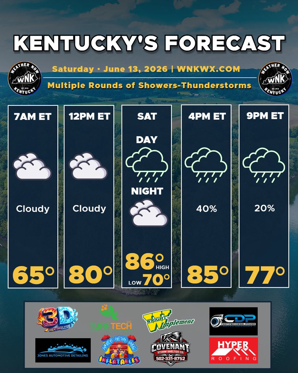
SATURDAY: Multiple rounds of showers and thunderstorms in the afternoon and overnight (into Sunday). Severe threat isn't 0, but low.
If you’re in or around Louisville and tired of fighting weeds, it’s time to call TurfTech. Their proven fertilization and weed control programs will give you the lush, healthy lawn your home deserves. - George
3
425
Here are the projected rain totals for Saturday. Multiple rounds of showers will lead to some Flash Flooding concerns. Some models extend this rainfall further East, I'll update with a fresh map in the morning! The good news is, this evening's data only points to a very low-end severe threat, mainly for damaging winds (if anything). The focus is now rainfall amounts!
Timing? Multiple rounds (2-7pm and 10pm-6am West to East). - George
1
6
617
Wow! If these newest data runs are accurate... Get ready for BUCKETS of water tomorrow, West Kentucky. I'll get a map to post for you later! This would lower the severe risk (all the rain). It would on the other hand present a respectable flash flood risk! - George
7
741