
WFLA-TV (Tampa Bay) Chief Meteorologist and Climate Specialist. BS Atmospheric Sciences Cornell U. MA Climate Columbia U. Past CBS News NY and Miami, Tampa, WPB
Joined November 2012
- Tweets 43,236
- Following 9,375
- Followers 58,515
- Likes 78,706
10,025 Photos and videos


Jeff Berardelli retweeted

Victory

8
636
6,962
612,737

Jun 12
It’s warming… faster.
Jun 12

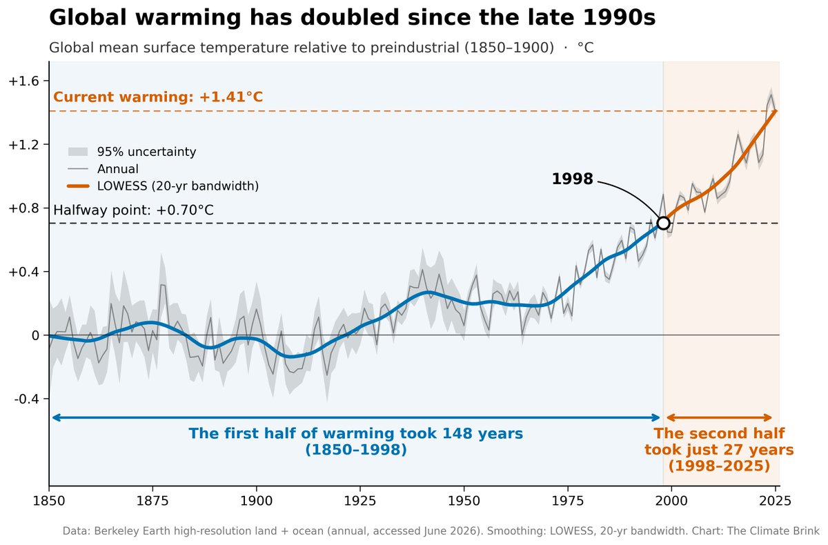
The world has warmed by around 1.4C since 1850.
It took 148 years for the first half of that warming to occur, and just 27 years for the second half!
22
95
335
9,280
Jun 12
If you are in the Tampa Bay Area join me tomorrow (Saturday) from 2-4pm to discuss the growing threat of heat, along with the @CityofTampa @CLEOInstitute @AARP @UTampaPress at the University of Tampa.
See you then! @FLcleanenergy
6
14
1,854
Jeff Berardelli retweeted

Jun 12
Strong El Niño periods often appear as an upward stairstep in long-term plots of global temperatures — but this El Niño, because of its expected intensity, could be worth two stairsteps instead of one.

2
27
64
5,055
Jun 12
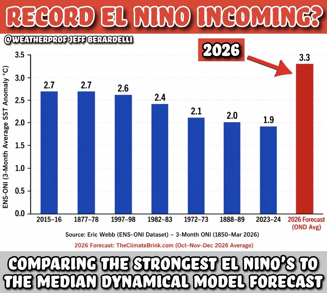
It’s official: El Niño has arrived… and odds are it may be the strongest in over a century! So how does it compare to other strong El Niño events? And what kind of impacts can we expect in Hurricane Season and into the winter in #Florida and along the Gulf Coast. Here’s a quick breakdown. #ElNino #HurricaneSeason #SevereWeather
3
28
64
2,877
Jun 12
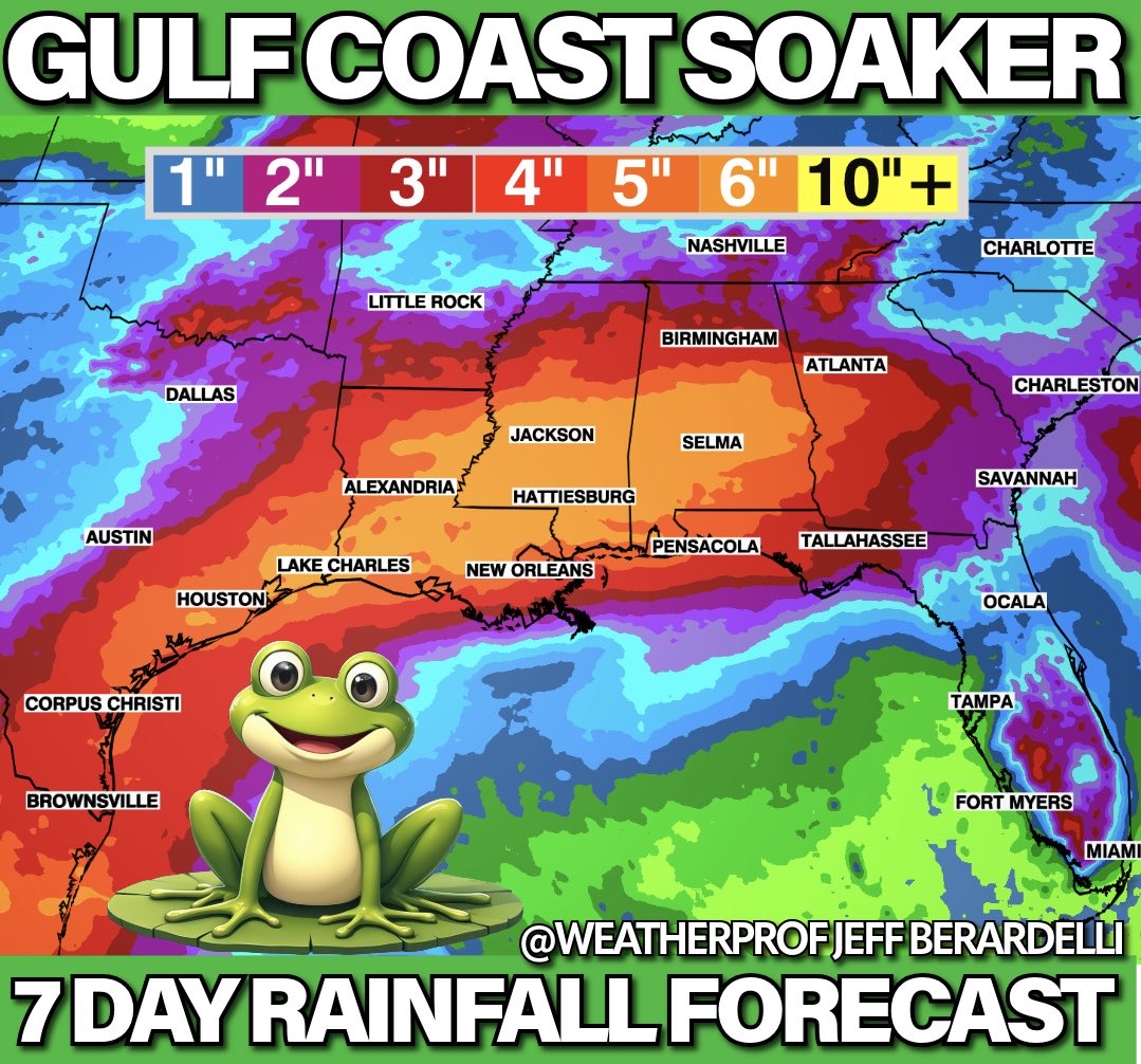
Big rains for the Gulf Coast!! That includes the Western Panhandle… but unfortunately it will miss most of the #Florida Peninsula - for now. Tropical moisture - which NHC still gives a low development chance - will round the coast and bring downpours to Texas, Louisiana, MS, AL, GA and the Panhandle over the next 7 days. NOAA says a widespread few to several inches will fall.
#rain #florida
6
32
1,794
Jun 11
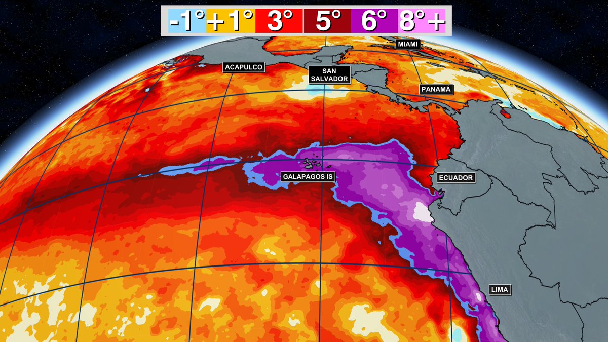
The area near the #Galapagos Islands are impressively hot. About 6-10F above normal. Obviously this has very negative implications for wildlife on/around the islands and the coastal communities / fisherman in Ecuador, Peru, etc...
Jun 11

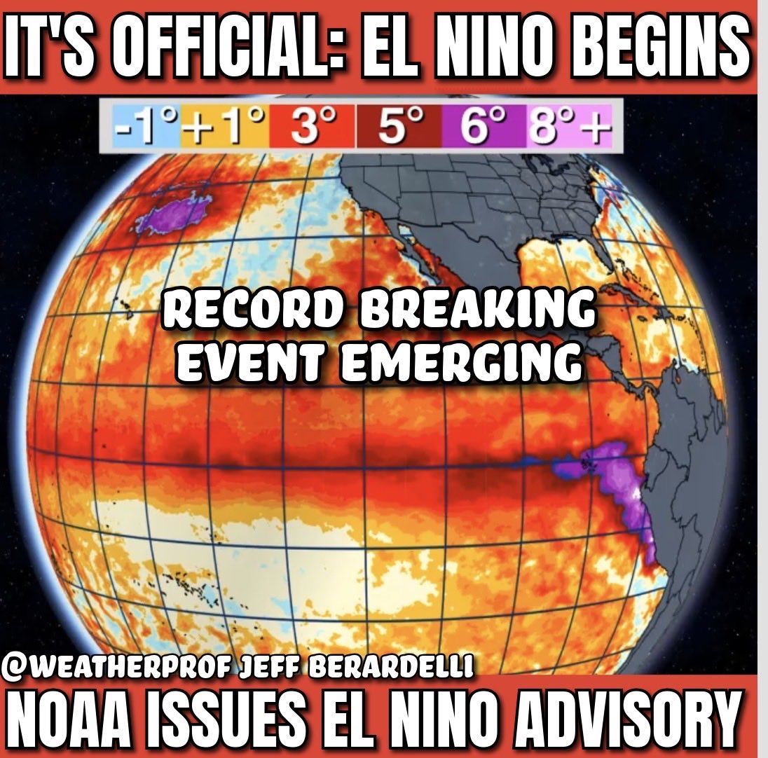
El Niño is born! Destined to be the biggest in 150 years ??
NOAA declares: El Niño Advisory
This morning conditions in the Eastern Pacific met the criteria for El Niño. This means Sea Surface Temps reached a certain level above normal, and the ocean and atmosphere “coupled” meaning they are now working in tandem to produce impacts. This event is widely advertised by models to be potentially the strongest on record. El Niño takes very hot water stored in the deep tropical west Pacific, pushing it east and up to the surface, lofting that heat into the atmosphere, which supercharges weather events and throws the climate off-kilter. This typical means more intense heatwaves & floods, but also it restrains the Atlantic hurricane season. So its impacts are both good and bad. One thing seems virtually certain: the heat released into the atmosphere will make for some unprecedented events through 2027, and on top of longterm warming, the hottest global temperatures in many tens of 1000s of years. #ElNino #florida #storm #heatwave #flood #drought
12
142
386
17,085
Jun 11
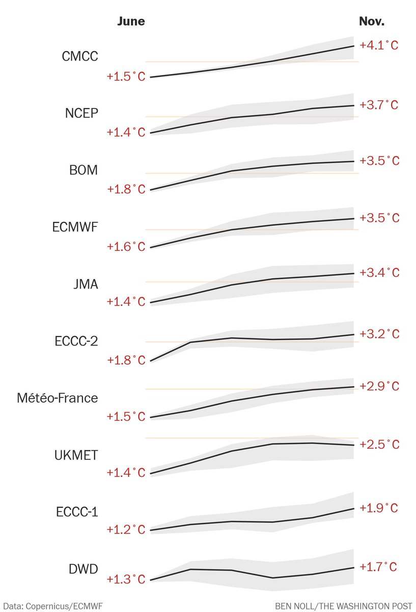
Each successive month has increased the forecast for El Nino... but that has leveled off in the last 2 cycles.
Jun 11
One advantage of having future predictions on my Climate Dashboard is that I can look back at how well they have performed compared to actual observations. For example, here are all the past ENSO predictions vs actual ENSO3.4 temps: dashboard.theclimatebrink.co…

3
4
36
2,564
Jeff Berardelli retweeted
Jun 11
7 out of 10 models now predict a record-breaking El Niño this year.
El Niño's exact intensity will influence the magnitude of the global temperature spike and water vapor levels in 2026-27, both key indicators of the potential for weather extremes. Fractions of a degree matter.
23
130
374
21,749
Jun 11
El Niño is born! Destined to be the biggest in 150 years ??
NOAA declares: El Niño Advisory
This morning conditions in the Eastern Pacific met the criteria for El Niño. This means Sea Surface Temps reached a certain level above normal, and the ocean and atmosphere “coupled” meaning they are now working in tandem to produce impacts. This event is widely advertised by models to be potentially the strongest on record. El Niño takes very hot water stored in the deep tropical west Pacific, pushing it east and up to the surface, lofting that heat into the atmosphere, which supercharges weather events and throws the climate off-kilter. This typical means more intense heatwaves & floods, but also it restrains the Atlantic hurricane season. So its impacts are both good and bad. One thing seems virtually certain: the heat released into the atmosphere will make for some unprecedented events through 2027, and on top of longterm warming, the hottest global temperatures in many tens of 1000s of years. #ElNino #florida #storm #heatwave #flood #drought
44
405
963
157,836
Jun 11
Breaking: El Niño begins!
NOAA has officially declared the start of El Niño today. After months of anticipation, the criteria has been met with East Pacific Ocean Temps rising at a record pace. The models have been consistently advertising a “historic” event, very possibly the strongest on record by fall. #ElNino
14
141
453
23,550
Jun 11
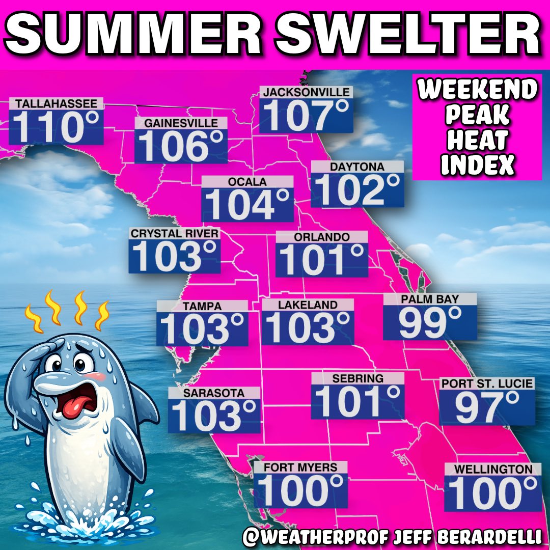
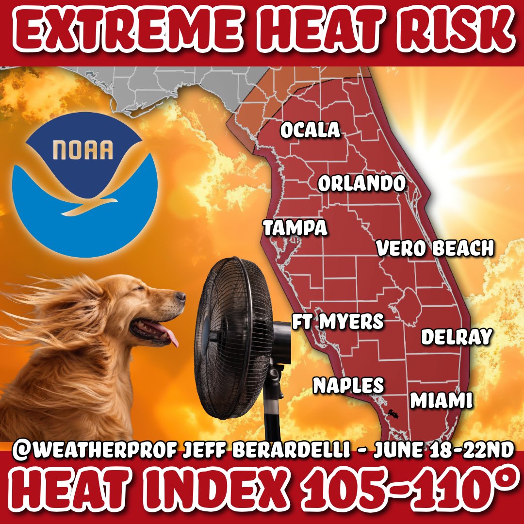
🥵 It’s not often NOAA Alerts Florida about the risk of Extreme Heat.
Heck, every day feels extreme to me🤣
But NOAA has put the state in an Extreme Heat Risk in about a week from June 22-18. This is for excess humidity combined with heat bringing widespread heat index numbers to 105°-110° 🥵 #florida #heat #heatwave
3
14
70
3,332
Jun 11
Japanese Meteorological Service (JMA) didn’t plan for this… To be fair neither have the other services.
That’s how off the charts these forecasts are.
Now we wait to see if they verify.
#ElNino
2
25
102
3,894
Jun 11
Notice the 2015-2016 record of 2.75°C
Jun 11
With June runs in for all the ENSO models and the "spring predictability barrier" mostly behind us, the odds of a record-breaking El Niño event this fall have continued to increase. Here are all the latest runs (including today's C3S updates):

1
13
38
3,650
Jun 10
“Crossover” storm may bring the first Atlantic system of the season! A little #science for u.
The National Hurricane Center has highlighted the SW Gulf for a chance of development. If it happens, it will be in a “somewhat” unique way. The remnant spin of Pacific Storm #Cristina will move across Mexico and merge with a moist trough of low pressure in the Bay of Campeche. When that happens in 2-3 days there’s a short window for the system to develop. The chances are not very high, but if it becomes a tropical storm the name will be #Arthur This does not look like a strong system, but it will bring tropical downpours & maybe flooding rain to Mexico, Texas and potentially other parts of the Northern Gulf Coast into next week. #hurricaneseason #storm
4
25
84
11,420
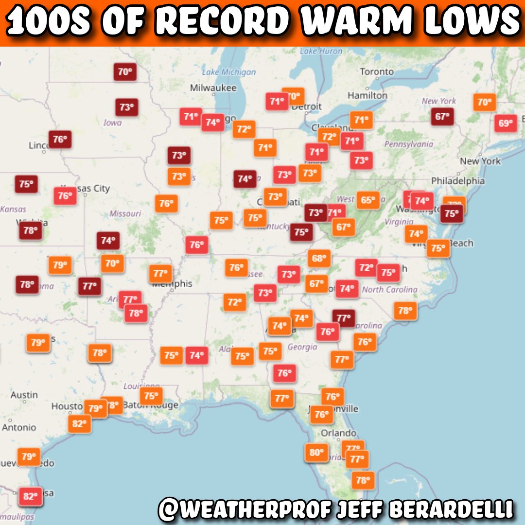
Jun 10
Morning temps are rising faster than afternoon temps. And it really shows during some heatwaves, especially ones in which the humidity is higher. Case in point: over the next 5ish days we will see 100s of record or near warm morning lows across the Eastern half of the nation (and along the West Coast too). Orange = near, red = ties, dark red = breaks. #heatwave
3
5
23
1,978
Jun 10
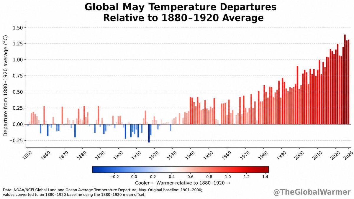
Starting soon all months will be the warmest on record once El Niño kicks into high gear. Biggest impacts on global temp will be later this year into next year. It will set a new precedent… for a couple of years… until it’s broken again.

NOAA reports May 2026 was the 2nd-warmest May on record globally for land and ocean temperatures.
Only May 2024 was warmer.
Relative to an 1880–1920 baseline, May 2026 was about 1.30°C.
16
74
248
8,394
Jun 10
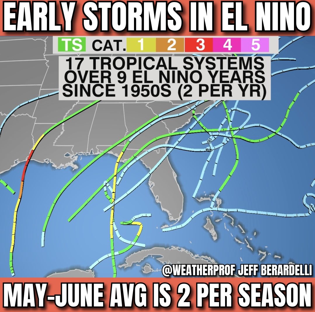
NHC has outlooked its first potential development in the SW Gulf today - a lemon 🍋 just 10% so far in the Bay of Campeche. It poses no threat to #Florida or the US.
But early season storms are common in El Niño years - we get about 2 per event. That’s because the impacts of the developing Pacific #ElNino don’t fully ramp up until mid summer. So for now the impending event has limited impact on subduing the Atlantic. That will change in a couple of weeks when the Pacific overpowers the Atlantic and quieter than normal conditions prevail. #hurricaneseason #hurricane
1
1
12
1,751