🛰️🌎 Windy is an extraordinary tool for #weather #forecast visualization. It's fast, intuitive, detailed & most accurate #app trusted by #professionals
Joined November 2014
- Tweets 10,610
- Following 2,856
- Followers 73,103
- Likes 11,486
4,247 Photos and videos


🌎 NOAA has officially declared the onset of El Niño
El Niño is the warm phase of ENSO, during which surface waters in the central and eastern tropical Pacific become warmer than usual.
As the distribution of warm water in the Pacific shifts, atmospheric circulation also changes, including the position of the jet stream and storm tracks. This can influence temperatures and rainfall thousands of kilometres away.
Current seasonal forecasts suggest that El Niño will continue to strengthen through the rest of the year. According to NOAA, there is a 60% chance that sea surface temperature anomalies in the central and eastern tropical Pacific will exceed 2 °C by the end of the year. This episode could therefore become very strong and rank among the strongest events on record.
Typical impacts of El Niño:
• globally: an increase in the planet’s average temperature
• more rainfall: western and southern South America, parts of East Africa, and the southern United States
• drier conditions: northern and eastern Australia, Indonesia, parts of Southeast Asia, southern Africa, and parts of Central America
• South Asia: the southwest monsoon is often weaker
• tropical cyclones: less favourable conditions in the Atlantic, a more active eastern and central Pacific, and typhoon formation in the western North Pacific often shifting farther east
12
166
485
37,156
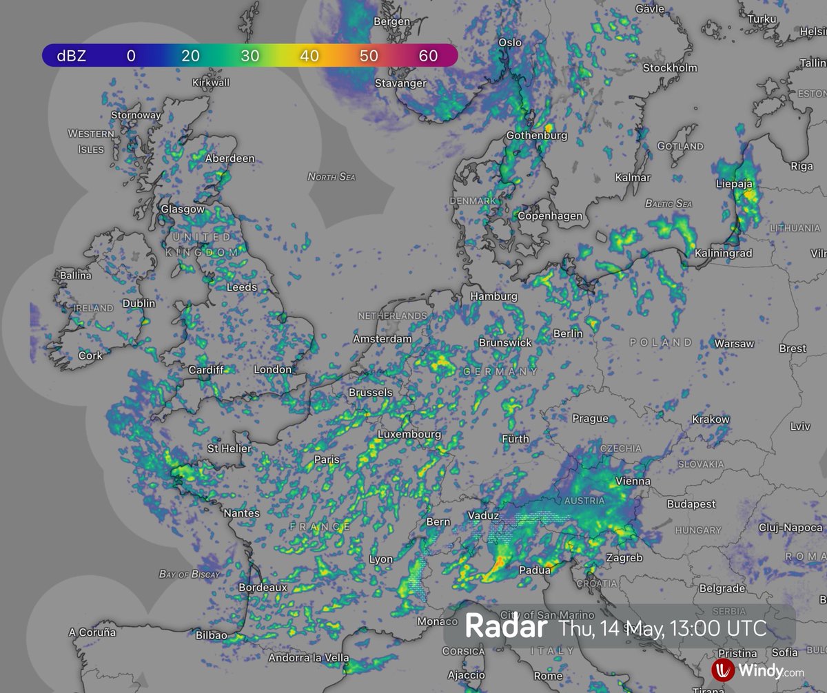
🌬️ The Mistral picked up in southern France on Tuesday and may still bring gusts of around 80 km/h on Thursday. It should start easing on Friday.
⚠️ At sea, it is generating waves over 3 metres high, while also increasing the risk of fire outbreaks in southern France, especially around the Rhône Delta area.
3
18
1,670
🌀 Tropical storms Boris and Cristina threaten the Pacific coast of Mexico and Central America
Tropical Storm Boris is moving inland along Mexico’s Pacific coast, southeast of Acapulco.
Tropical Storm Cristina has formed near the Pacific coast of Central America and will move near the coasts of Nicaragua, Honduras, and El Salvador on Tuesday and Wednesday. It is likely to move inland near El Salvador.
Despite their expected rapid weakening over land, both storms will still bring very heavy rainfall.
Boris: additional rainfall totals of 3 to 6 inches (75 to 150 mm), locally up to 8 inches (200 mm), across coastal Guerrero and Oaxaca in Mexico.
Cristina: rainfall totals of 4 to 8 inches (100 to 200 mm), locally up to 12 inches (300 mm), across coastal areas of Nicaragua, Honduras, El Salvador, and Guatemala.
The rainfall may cause life-threatening flooding and mudslides, especially in areas of steep terrain. Dangerous surf is also expected along the coast.
⚠️ Please follow the latest warnings and instructions from local authorities.
15
75
5,005
🌀 Tropical Storm Boris heads toward Mexico’s Pacific coast
Tropical Storm Boris has formed just off Mexico’s Pacific coast. By Monday evening, its centre is expected to move over the coast of the Mexican state of Guerrero, southeast of Acapulco. Boris is likely to become the first named storm of the 2026 hurricane season to move inland.
According to the NHC, on Monday, June 8, at 3:00 a.m. CST (09:00 UTC):
Location: 50 mi (80 km) southwest of Punta Maldonado, Mexico
Intensity: maximum sustained winds of 40 mph (65 km/h)
Movement: toward the northeast at around 5 mph (8 km/h)
On Monday, Boris is expected to turn northwest and may strengthen slightly. After moving inland, however, it should weaken rapidly and dissipate by Tuesday.
For the coast of Guerrero and western Oaxaca, the main risks are:
Wind: gusts up to 45 mph (70 km/h) in exposed locations
Heavy rain: totals of 4 to 10 inches (100 to 250 mm), with local maximum totals of 12 inches (300 mm) possible through Monday night. This rainfall may produce life-threatening flooding and mudslides, especially in areas of steep terrain.
Waves and storm surge: dangerous surf, local coastal flooding, and waves up to around 3 m
⚠️ Please follow the latest warnings and instructions from local authorities.
10
48
3,198
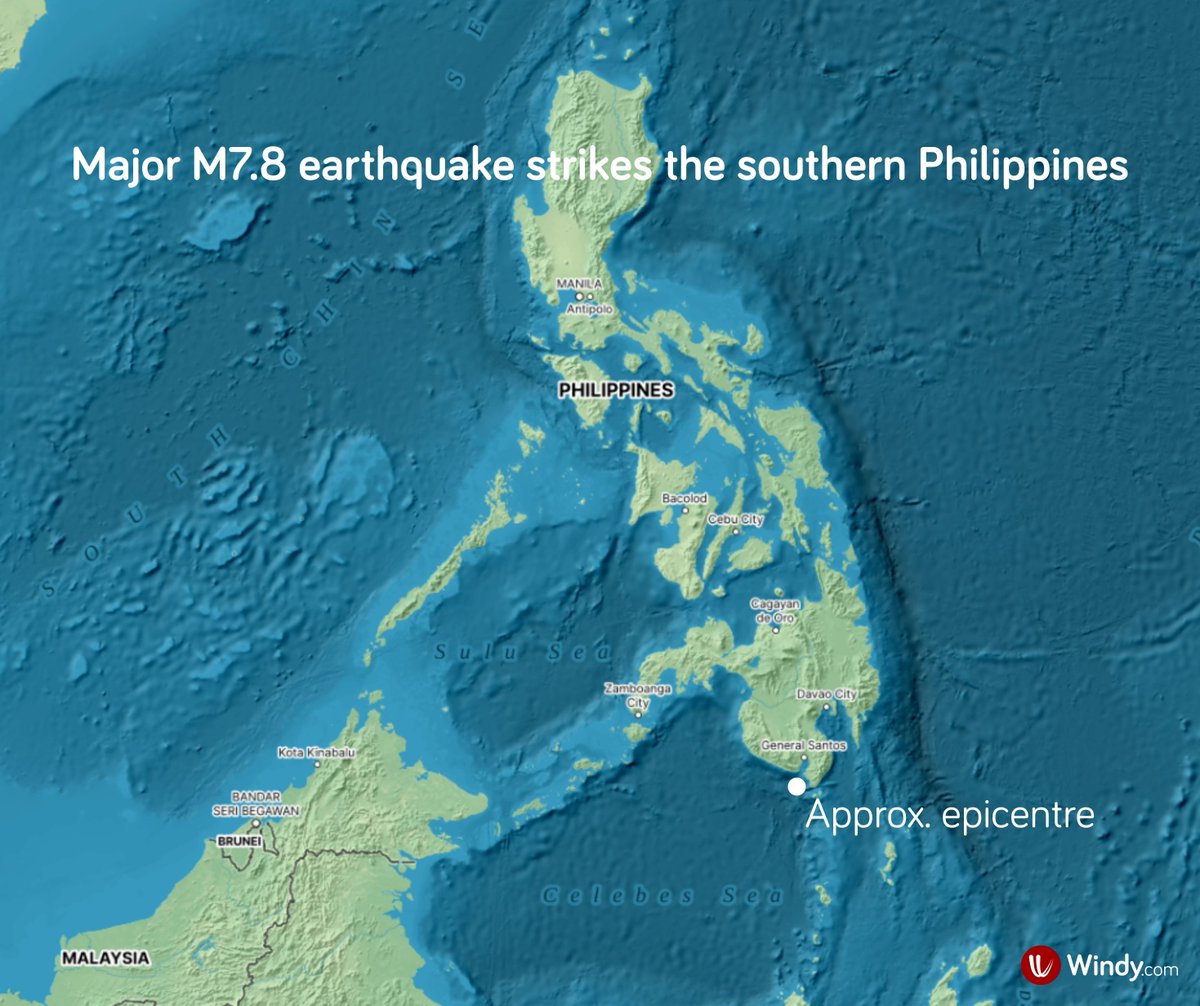
🇵🇭 Major M7.8 earthquake hits the southern Philippines
On Monday, June 8, 2026, at 7:37 a.m. local time, a major M7.8 earthquake struck the Celebes Sea near southern Mindanao. According to the USGS, the epicentre was located 26 km southwest of Cablalan, with a hypocentre at a depth of about 55 km. Aftershocks are continuing, with some epicentres located on land near Pangyan and Burias.
The earthquake caused serious damage, especially around General Santos City. Injuries and fatalities have been reported. Some coastal areas of the southern Philippines recorded tsunami waves of around 1 m, but the main tsunami threat has now largely passed.
The region is highly seismically active due to its complex tectonic setting, where several smaller plates accommodate the convergence between the Philippine Sea Plate and the Sunda Plate. Since 1900, 35 earthquakes of magnitude M7 or higher have occurred within 300 km of this event (USGS).
1
8
38
2,272
🌈 Did you know that rainbows move?
On Thursday, June 4, a rainbow formed over Kīlauea volcano in Hawaiʻi 🌋, directly in the webcam view of Halemaʻumaʻu crater. In three consecutive webcam images, its position gradually changed.
But why?
☀️💧 A rainbow forms when sunlight enters water droplets in the atmosphere. The light is refracted, dispersed into different colours, and internally reflected inside the droplets.
A rainbow’s position depends on the exact geometry between the Sun, water droplets, and the observer. You usually see a rainbow when the Sun is behind you and water droplets are in front of you.
Because a rainbow is always seen opposite the Sun, its position shifts as either the observer or the Sun appears to move.
📷 In this case, the webcam stayed in the same place, but later in the day, the Sun moved lower towards the horizon. As a result, the rainbow shifted higher in the webcam view, and a larger part of its arc became visible.
2
22
1,759
🌧️ Southwest monsoon reaches southern India 🇮🇳
The southwest monsoon reached Kerala in southern India on Thursday, June 4, according to the India Meteorological Department (IMD). This is a few days later than the usual onset date of June 1.
The summer monsoon carries moist air to India, easing pre-monsoon heat and delivering much-needed rainfall after the dry season.
In 2026, the monsoon season is expected to be weaker than normal. From June to September, India as a whole is forecast to receive around 90% of its long-period average (LPA), which is about 870 mm.
Regional outlook from the IMD:
• Central India and southern peninsular India: below normal, less than 94% of LPA
• Northwest India: below normal, less than 92% of LPA
• Northeast India: normal, 94 to 106% of LPA
The weaker outlook is partly linked to the developing El Niño in the equatorial Pacific, which can alter tropical circulation and reduce the flow of moisture from the Indian Ocean towards the subcontinent.
3
26
273
17,770
🌧️ Tropical Storm Jangmi, referred to in Japan as Typhoon No. 6, brought exceptional rainfall to Japan’s Pacific coast.
In Owase, Mie Prefecture, 473 mm of rain fell in just 12 hours, nearly half a metre.
The rain has stopped, but the risk of landslides remains elevated for now. ⚠️
1
15
74
8,246
🌀 Tropical Storm Jangmi brings heavy rain and strong winds to Japan
Tropical Storm Jangmi, known in Japan as Typhoon No. 6, is moving very close to Kyushu and bringing strong winds and heavy rain to parts of Japan.
The storm is affecting Kyushu, Shikoku, and the southern half of Honshu. Due to heavy rainfall, the Japan Meteorological Agency has issued a level 4 flood warning for the Hirowatari and Sakatani rivers in Miyazaki Prefecture, on the southeastern coast of Kyushu.
On Tuesday, June 2, at 14:00 JST (05:00 UTC):
Location: near Yakushima
Intensity: sustained winds of 90 km/h, with gusts up to 126 km/h
Movement: northeastward at approximately 30 km/h
Jangmi is expected to track very close to the coasts of Kyushu, Shikoku, and Honshu, with its centre possibly moving over land several times, most likely south of Kyoto and Yokosuka. Although it should gradually weaken, it is expected to remain a tropical storm.
Very heavy rain and strong winds are expected to reach the Kanto region, including Tokyo, early on Wednesday, June 3. Conditions should improve later in the afternoon.
The highest risk mainly concerns eastern Kyushu, Shikoku, and the southeastern coast of Honshu.
Wind: gusts over 100 km/h, up to 120 km/h in exposed areas
Rain: 150–200 mm, locally up to 300 mm; 100–150 mm in Kanto; flooding and landslides are possible
Storm surge and waves: very rough seas, waves up to 7 m
Please follow the latest forecasts and instructions from local authorities. ⚠️
6
37
5,846
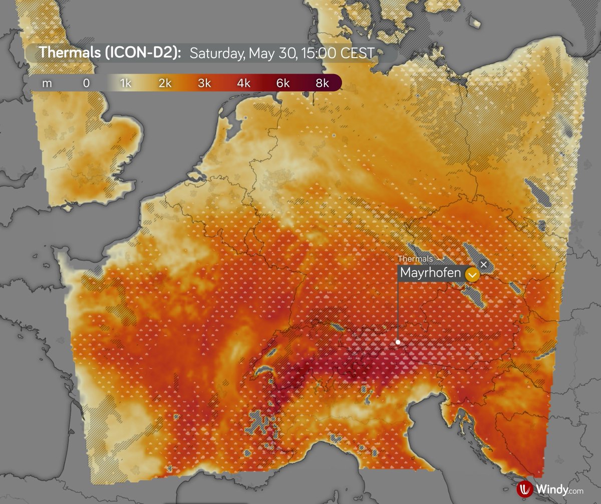
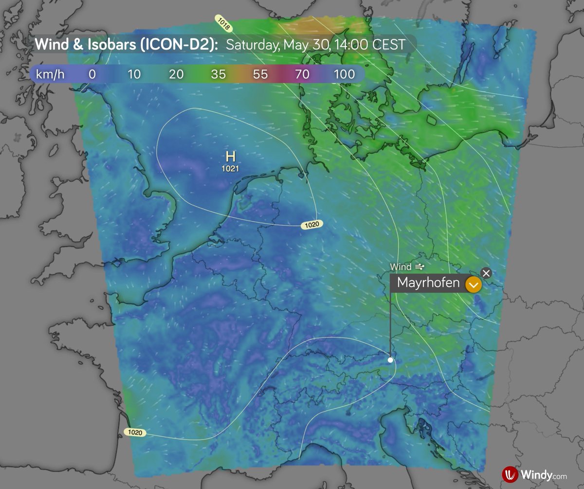
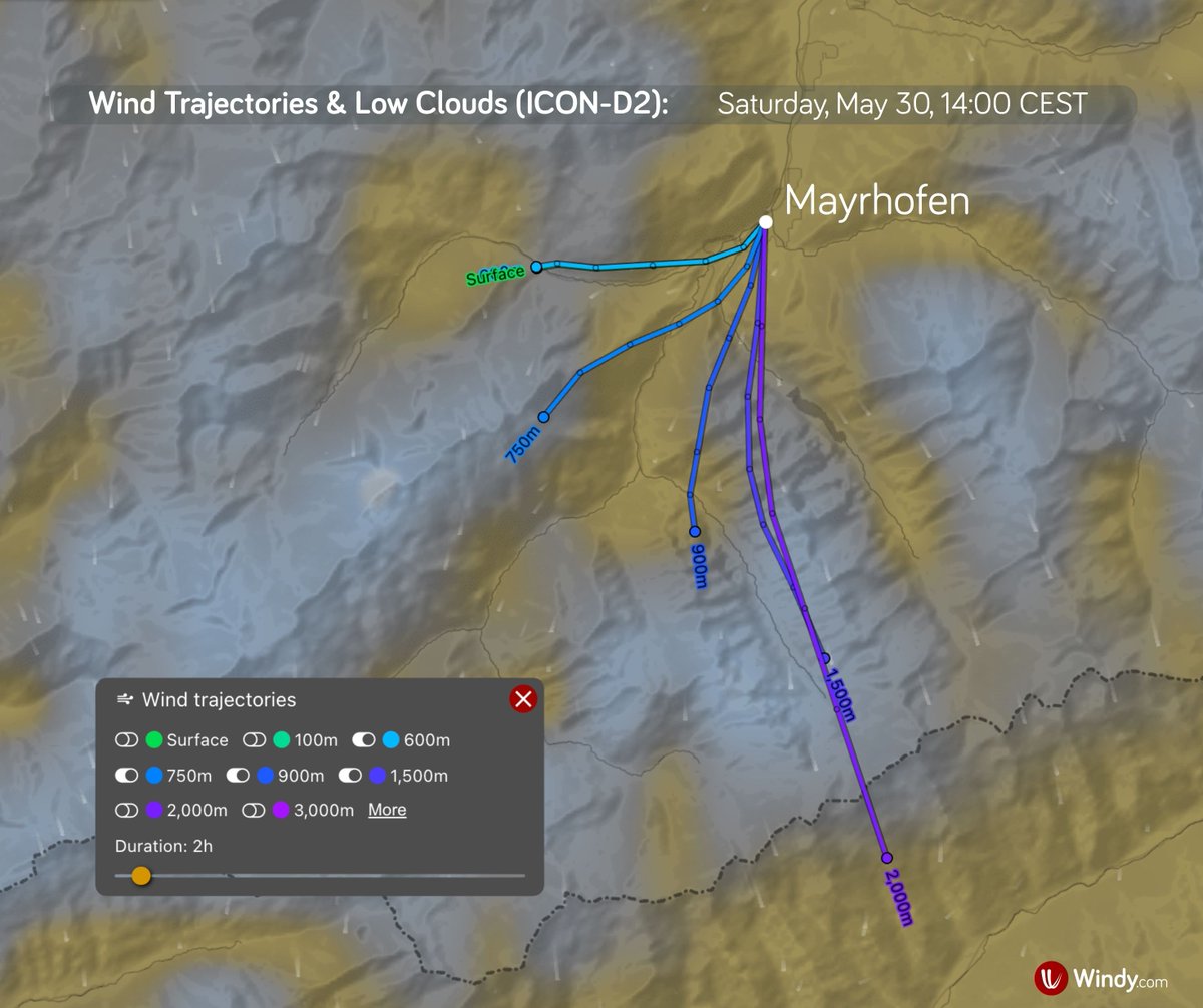
🪂 Mayrhofen lives and breathes paragliding
The Red Bull X-Alps Challenger Mayrhofen is taking place in the Zillertal Valley, where Saturday’s weather will be important for both athletes and anyone following flying conditions in the mountains.
A weakening ridge of high pressure extending from the southwest will influence the area.
🌡️ Temperature
Around 12 °C in the valley in the morning and about 26 °C in the afternoon.
☁️ Clouds and showers
Thin high cloud may appear in the morning, with the sun still shining through. During the afternoon, cumulus clouds may develop, bringing local showers. A thunderstorm cannot be ruled out later.
💨 Wind
Valley winds should remain light to moderate, mostly up to 12 km/h, mainly from the north. At 700 hPa, winds will be around 22 km/h, mainly from the north, later turning northwest and briefly strengthening.
🪂 Thermals
Thermals should start developing during the morning. The convective condensation level may briefly rise to around 3,000 m after midday.
Overall, it looks like a flyable day, especially from the morning to around midday. More caution will be needed in the afternoon due to stronger thermals, cumulus development, and possible showers or a thunderstorm.
16
1,912
🌀 Tropical depression Jangmi intensifies in the western Pacific
Tropical depression Jangmi began forming on Wednesday near the Caroline Islands.
Thanks to favorable conditions, including sea surface temperatures of around 29-30 °C and weaker vertical wind shear, it continues to strengthen as it moves northwestward.
As of Thursday, May 28, at 03 UTC, according to JTWC:
Location: approximately 430 km NW of Yap Island
Intensity: sustained winds of around 56 km/h, with gusts up to 75 km/h
Movement: approximately 24 km/h toward the NW
Jangmi is expected to continue on its current track and intensify further. It is forecast to reach typhoon strength on Saturday and likely peak on Sunday.
The system should pass at a considerable distance from the Philippines 🇵🇭, but seas may become moderate to rough along the coast of Extreme Northern Luzon.
Early next week, the typhoon may pass near or over Okinawa 🇯🇵 and begin turning northeastward. Depending on its exact track, it may then move closer to other parts of Japan, especially Kyushu, Shikoku, and Honshu.
⚠️ Please follow official forecasts and warnings.
1
13
34
4,554
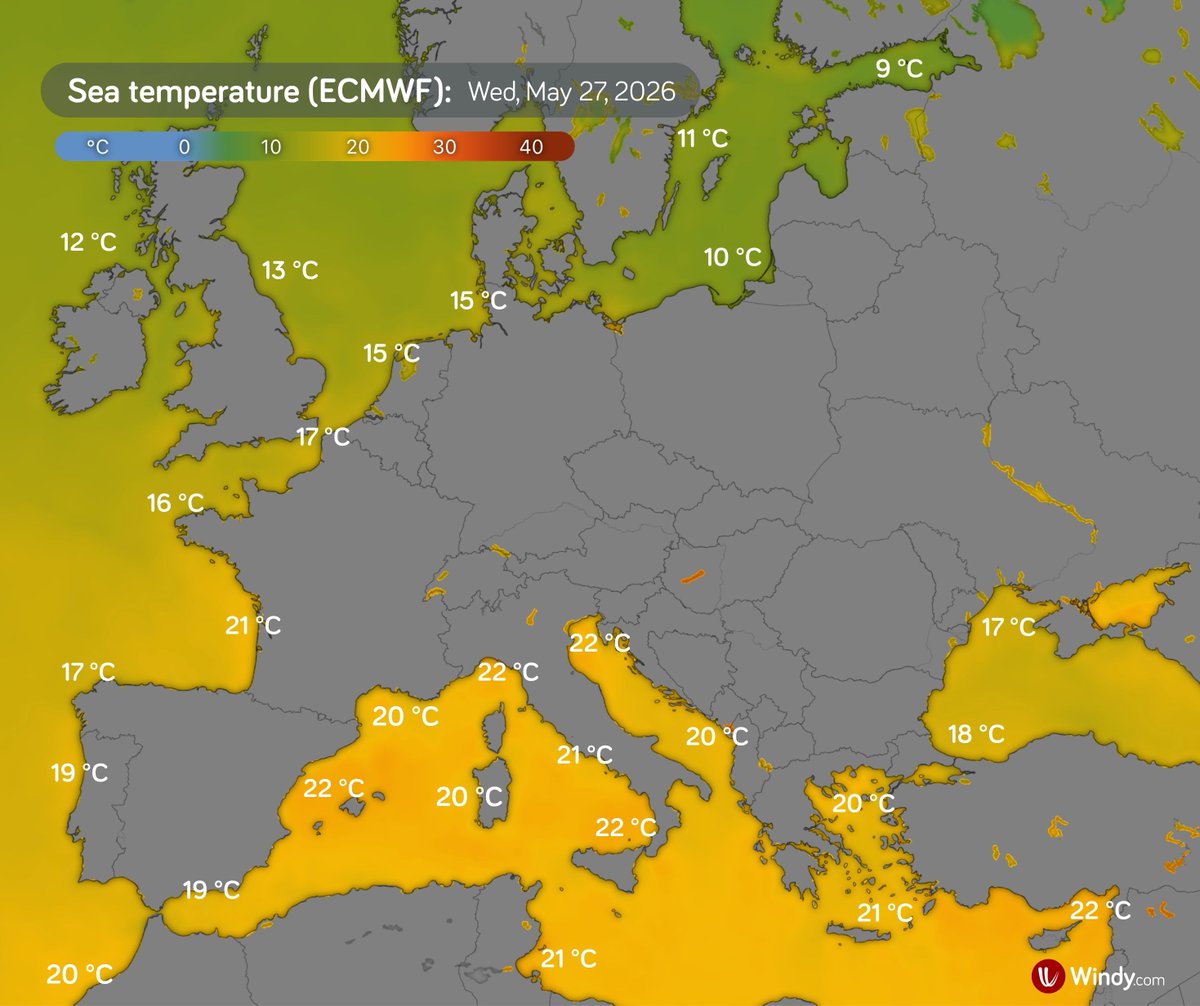
🌊☀️ Sea surface temperatures are rising along parts of Europe’s coast
The current heatwave is affecting more than just the air. Sea surface temperatures are also unusually high in several European coastal areas.
Along parts of the Atlantic coast, water temperatures are locally more than 4 °C above normal for late May. A similar pattern is evident in the western Mediterranean, while the eastern Mediterranean remains near- to slightly below-normal.
🌡️ Atlantic and western Europe
• North Sea, Benelux area: 14–16 °C, around 3 °C above normal
• English Channel: 15–17 °C, around 4 °C above normal
• Brittany coast: 15–17 °C, around 2 °C above normal in the north
• Bay of Biscay: 19–22 °C, locally more than 4 °C above normal
• Galicia, northwestern Spain: 17–20 °C, around 3 °C above normal
• Western coasts of Spain and Portugal: 18–20 °C, around 3 °C above normal
• Southern Portugal: around 19 °C, near normal
🌡️ Mediterranean Sea
• Southern Spain: 19–20 °C, around 1 °C above normal
• Eastern Spain and the Balearic Islands: 20–22 °C, locally around 3 °C above normal
• Southern France: 19–21 °C, around 3 °C above normal
• Corsica and Sardinia: mostly around 20 °C, locally up to 22 °C along eastern Corsica, around 1 °C above normal
1
9
41
4,299
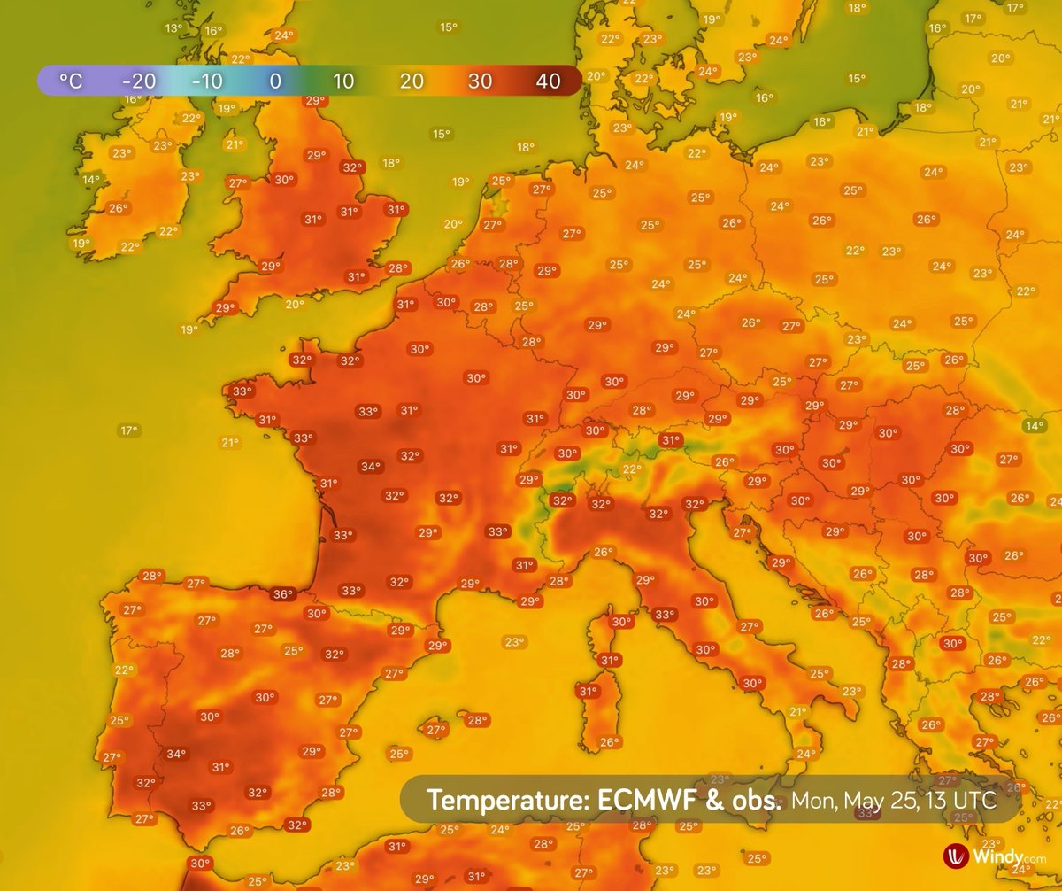
🌡️ Europe’s exceptional May heatwave reaches its hottest day so far on Tuesday
A heat dome over western Europe is blocking frontal systems and allowing very warm air to accumulate near the ground. As a result, temperatures are climbing to unusually high values for late May.
Tuesday, 26 May 2026, brought extreme heat to many parts of southwestern, western, and central Europe.
According to national meteorological services:
🇬🇧 United Kingdom
Tuesday was the hottest May day on record in both England and Wales. Kew Gardens provisionally reached 35.1 °C, while Cardiff Bute Park reached 32.9 °C.
🇫🇷 France
The provisional national thermal indicator reached 24.8 °C at 5 p.m., making Tuesday the hottest May day ever recorded nationwide in France.
🇪🇸 Spain
Typical July values have already been recorded across the country. Montoro, Córdoba, reached 38.8 °C, while Santander, Cantabria, set a new May maximum temperature record with 37.1 °C.
🇵🇹 Portugal
Continental Portugal also recorded very high temperatures, with Mora reaching 38.5 °C.
The heat is not over yet. In southwestern Europe, the heatwave is expected to intensify further, with temperatures in the coming days likely to resemble the hottest part of the year.
In central Europe, the heat will ease slightly on Wednesday and Thursday as a weak cold front passes through, but temperatures will remain well above the long-term average.
Over the weekend, the heat should also partly ease across the British Isles as a frontal system passes.
⚠️ Follow official forecasts and warnings from your national meteorological service.
17
70
6,330
🌡️ Exceptional May heatwave continues in Europe
Southwestern and Western Europe, as well as parts of Central Europe, are experiencing very high temperatures. In many places, temperatures have been climbing well above 30 °C for several days.
The cause is a large area of high pressure, a so-called “heat dome,” which extends across much of Europe and keeps hot air trapped beneath it.
On Sunday, for example, the following temperatures were recorded:
🇪🇸 Spain: 38.1 °C — Montoro, Córdoba
🇵🇹 Portugal: 34.2 °C — Amareleja, Beja
🇫🇷 France: 35.9 °C — Pruniers, Centre-Val de Loire
🇬🇧 United Kingdom: 32.8 °C — Teddington Bushy Park, London
🇩🇪 Germany: 33.2 °C — Regensburg, Bavaria
Very warm weather will continue in many places over the coming days. In Central Europe, the heat will temporarily ease on Wednesday as a weak cold front moves southward across the region.
7
18
98
8,539
🌡️ Unusually intense May heatwave in Europe
This weekend will bring very high temperatures to southwestern, western, and partly central Europe, locally up to 15 °C above the long-term average.
The reason is a persistent high-pressure system over Europe, drawing in hot air from North Africa along its western flank and acting as a so-called heat dome.
Air in the center of the high sinks and warms, suppressing cloud formation and allowing more solar radiation to reach the surface. As a result, hot air accumulates near the ground and continues to intensify.
Temperatures may exceed 30 °C in western and central Europe, and reach up to 38 °C in southwestern Spain.
Numerous daily temperature records are expected to be broken.
4
61
186
12,945
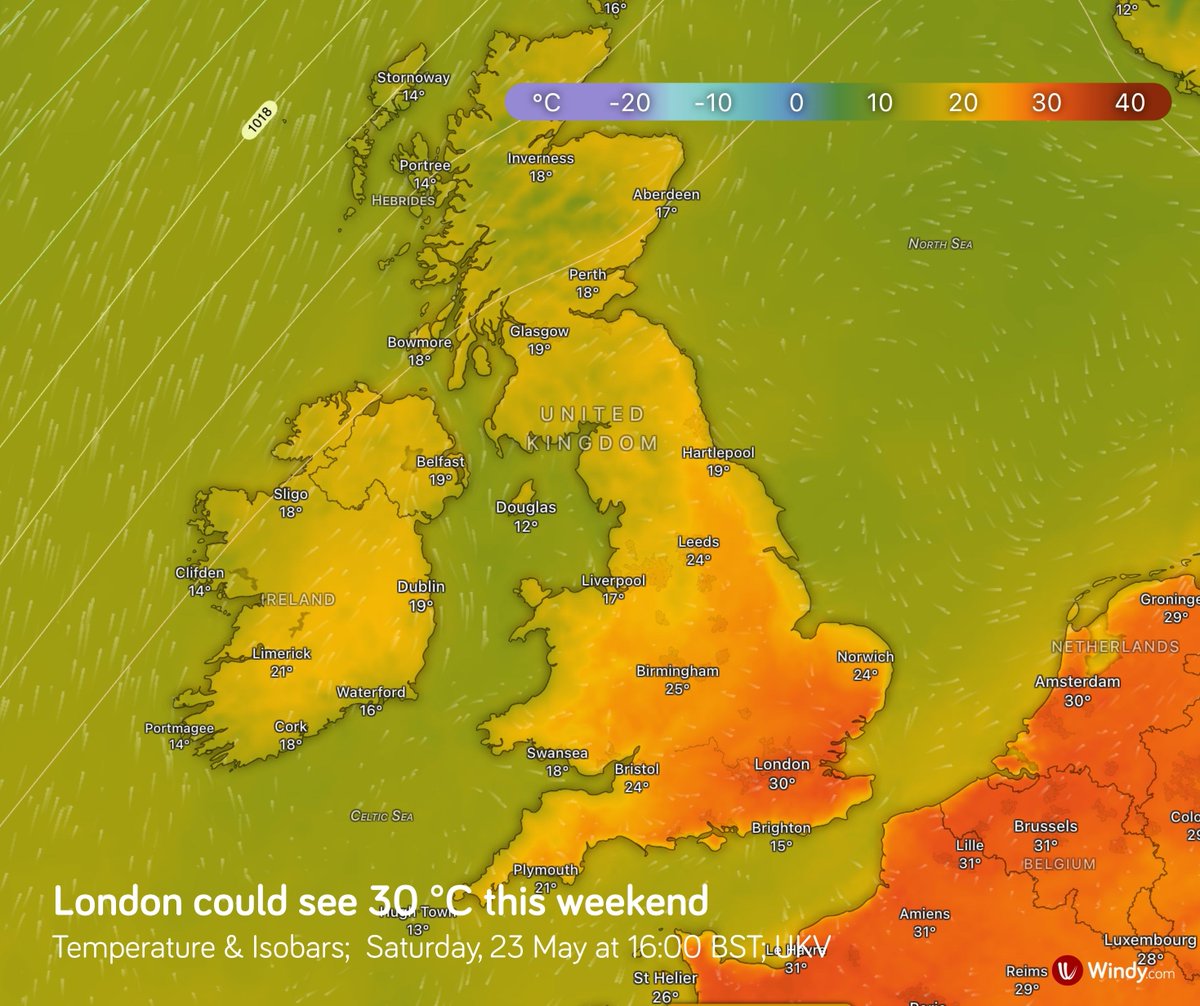
🌡️ Could southern England see its first heatwave of the season?
A blocking high over western Europe will bring warmer air northwards over the British Isles in the coming days.
From Friday, temperatures in southern England could locally reach up to 30 °C.
While 30 °C in May is unusual, it’s not unprecedented.
So, will it officially count as a heatwave? 🤔
For now, it’s still too early to tell. It depends on whether temperatures exceed regional thresholds (typically 25–28 °C in the UK) for at least three consecutive days.
3
33
3,741
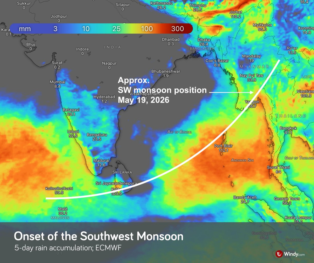
🌧️ Strong southwest monsoon over the Andaman Sea, Thailand, southern Myanmar, and the Gulf of Thailand
According to the India Meteorological Department, the southwest monsoon has advanced over southern Sri Lanka, the Andaman and Nicobar Islands, Thailand, and southern Myanmar.
In the coming days, it is expected to bring very heavy rainfall, especially over the islands in the Bay of Bengal and along its eastern coast, particularly across Thailand and southern Myanmar.
Relatively strong winds are generating waves of 2–3 meters in the upper Andaman Sea, potentially exceeding 3 meters in thundershowers. ⚠️

4
19
204
19,776
🌪️ A significant severe weather outbreak continues across the central USA
Numerous severe storms are expected this afternoon and evening across the southern central Plains and the Missouri Valley. Supercells capable of producing very large to giant hail (2”–4” ), damaging winds, and tornadoes, some potentially strong (EF2/EF3 ), are most likely over central Kansas and southeast Nebraska, extending into Iowa and northwest Missouri.
⚠️ According to the NOAA Storm Prediction Center, the tornado threat is higher this afternoon and evening compared to yesterday.
⚠️ Intense rainfall associated with thunderstorms may trigger flash flooding.
Tomorrow, storm activity will shift farther south and east, bringing showers and thunderstorms to the Great Lakes, and later to the Ohio Valley and the Mid-South. Stronger storms are expected from eastern Texas into the lower Mississippi Valley.
On Wednesday, more significant thunderstorm activity should be confined mainly to Texas.
3
36
2,508
🌀 Von Kármán vortex streets: a fascinating pattern in the atmosphere
These striking cloud formations appear when airflow passes around an isolated obstacle, such as an island or mountain peak, in a stable atmosphere with sufficiently strong, uniform winds.
Downstream of the obstacle, vortices are shed alternately, creating a regular chain of counter-rotating structures.
These vortices are then advected by the flow and gradually dissipate as they move into the wake.
A remarkable example of atmospheric dynamics visible from space. 🛰️
17
74
3,002