
Amazing maps brought to your attention. Turn our tweet notifications ON to never miss a tweet! Business/Map Ideas
Joined March 2011
- Tweets 10,470
- Following 13,504
- Followers 596,145
- Likes 1,224
2,943 Photos and videos


Pinned Tweet

Jun 1
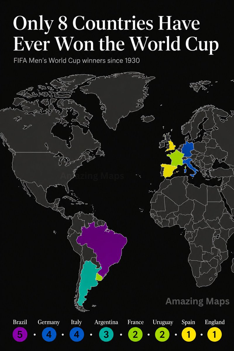
Only eight nations have reached football's summit.
104
349
5,154
415,745
When Virginia claimed half a continent
The evolution of Virginia's territorial claims, 1609–1863
10
26
637
49,129
At one point, Virginia claimed a vast swath of North America stretching from the Atlantic coast to the Pacific Ocean.
Granted by the Virginia Company in 1609, the claim reflected the European practice of drawing enormous colonial boundaries on maps long before those lands were explored, settled or controlled. In reality, much of the territory remained inhabited by Indigenous peoples and was also claimed by other European powers.
Over the next two and a half centuries, Virginia's claimed territory was steadily reduced as new colonies, territories and states were created. By the time West Virginia separated during the Civil War in 1863, the once-enormous claim had been reduced to something much closer to the Virginia we know today.
2
1
31
15,582
One of the clearest patterns on this map is the concentration of blonde hair around the Baltic Sea and across much of Northern Europe. Countries such as Finland, Sweden, Norway and Iceland are often reported to have some of the world's highest proportions of naturally blonde populations.
The distribution is not random. Hair colour is influenced by genetic variants affecting pigmentation, and blonde hair appears to have become especially common in northern Europe over thousands of years. However, the transition is gradual rather than absolute. Blonde hair remains widespread in many parts of Central Europe and can be found throughout the continent.
As with many demographic maps, national averages can hide significant regional differences. The map highlights broad population patterns rather than the appearance of any individual country, region or community.
1
32
16,836
Jun 12
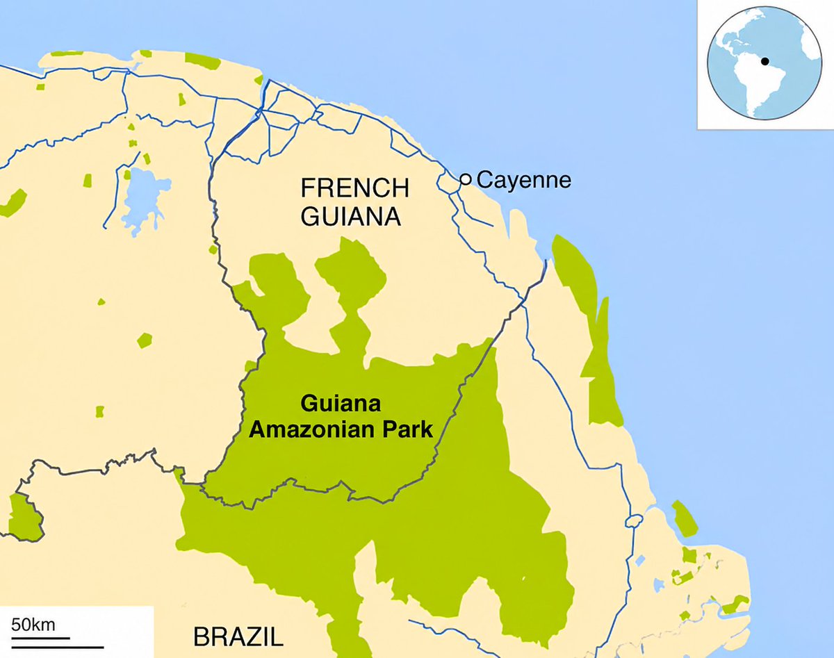
The European Union extends far beyond Europe itself. One of its outermost regions, French Guiana, is located on the northern coast of South America and is legally part of France.
That means Guiana Amazonian Park, a vast protected area covering nearly 34,000 square kilometres of Amazon rainforest, is not only a French national park but also the largest national park in the European Union.
It's one of the more surprising reminders that EU territory stretches from the Arctic to the Amazon.
2
46
14,591
Jun 11
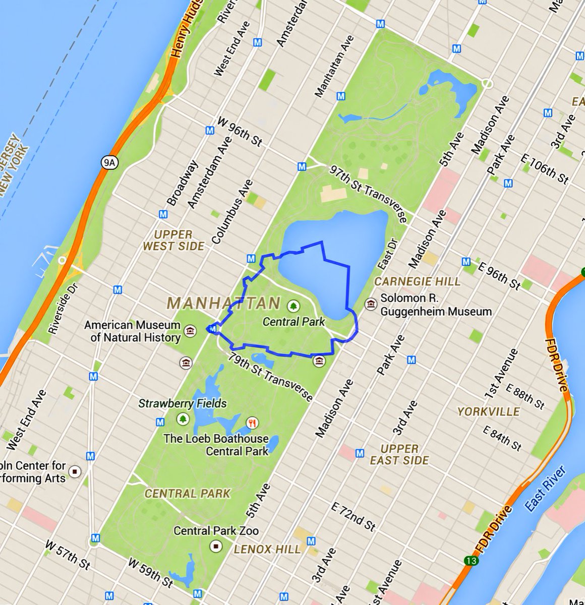
The world's smallest country compared to Central Park
22
31
720
88,722
Jun 11
Historic counties of the United Kingdom, coloured by name suffix
14
19
259
35,270
Jun 11
County names in the UK preserve layers of history stretching back more than a thousand years. The familiar -shire ending comes from the Old English scír, an administrative district, and is by far the most common suffix in England.
Other endings tell different stories. Norfolk and Suffolk literally mean the "north folk" and "south folk", while names such as Shetland, Rutland and Cleveland derive from older words for territories or regions. Some counties, including Kent, Essex and Surrey, preserve the names of ancient peoples and kingdoms rather than sharing a common suffix.
Together, these names offer a glimpse into the linguistic and political history of the British Isles, from Anglo-Saxon kingdoms to medieval shires and beyond.
3
2
50
14,250
Jun 10
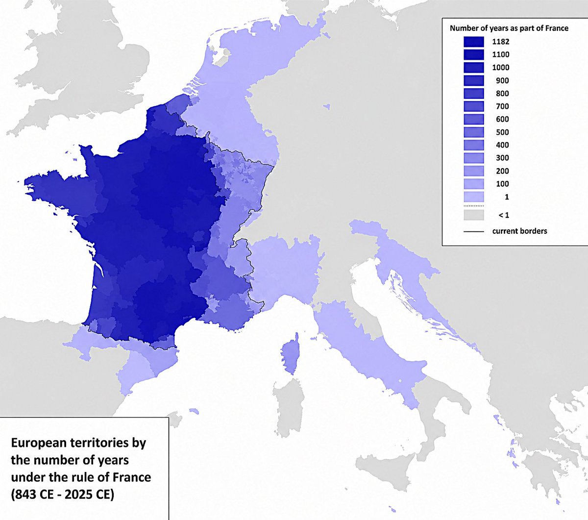
How long different parts of Europe were ruled by France
21
36
749
62,381
Jun 10
This map shows the cumulative number of years each territory has spent under French rule since the division of the Carolingian Empire in 843.
The darkest areas correspond to the historic core of the French kingdom, where French political authority has existed for more than a millennium. Moving away from that core, the total drops as territories were incorporated later, changed hands repeatedly, or experienced only brief periods of French control.
1
1
34
16,213
Jun 9
Temperature change across the United States, 1900–2020
18
21
297
36,589
Amazing Maps retweeted

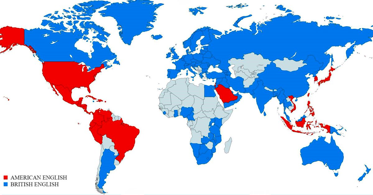
Soy team British English. ¿Y tú?

7
2
96
48,969
Jun 7
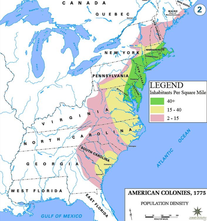
Population density across the American Colonies, 1775
17
36
531
51,278
Jun 7
On the eve of the American Revolution, most of the colonial population lived relatively close to the Atlantic coast.
Population was concentrated in coastal regions, river valleys and a handful of growing port cities such as Boston, New York, Philadelphia and Charleston, while most European settlement remained east of the Appalachian Mountains.
The Thirteen Colonies had a population of around 2.5 million in 1775. Today, that is smaller than the population of many individual U.S. metropolitan areas.
1
43
21,265