
Map of Natural Disasters: #Fire, #Flood, #Hurricane, #Tornado, #Earthquake #Volcano #Tsunami Operated by @SyndicatedMaps
Joined September 2017
- Tweets 3,021
- Following 563
- Followers 193
- Likes 656
154 Photos and videos


29 Oct 2025
Gavin Newsom’s Resume: $1 Trillion Disasters & Mismanagement disasterreliefmaps.com/2025/…

1
4
6
47
Disaster Relief Maps retweeted

22 Oct 2025
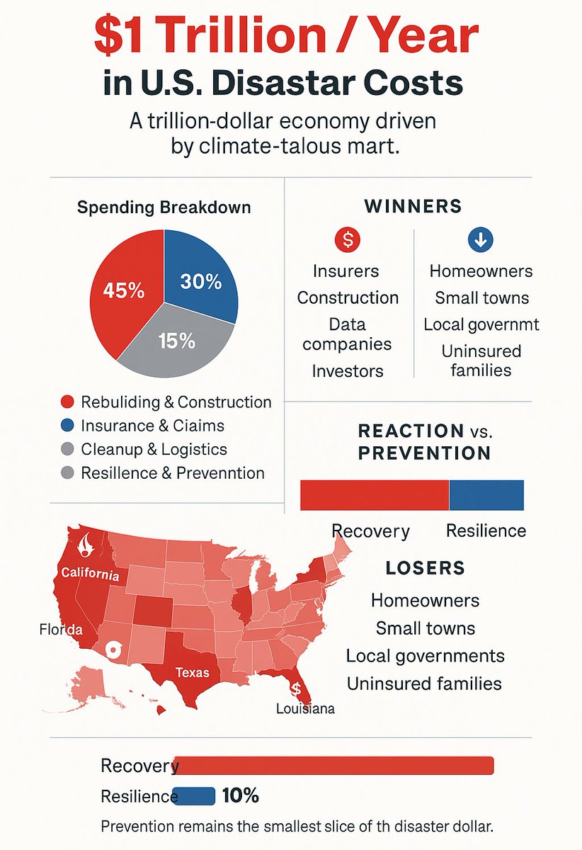
The Rise of America’s Disaster Economy disasterreliefmaps.com/2025/…
1
2
32
Disaster Relief Maps retweeted

8 Oct 2025
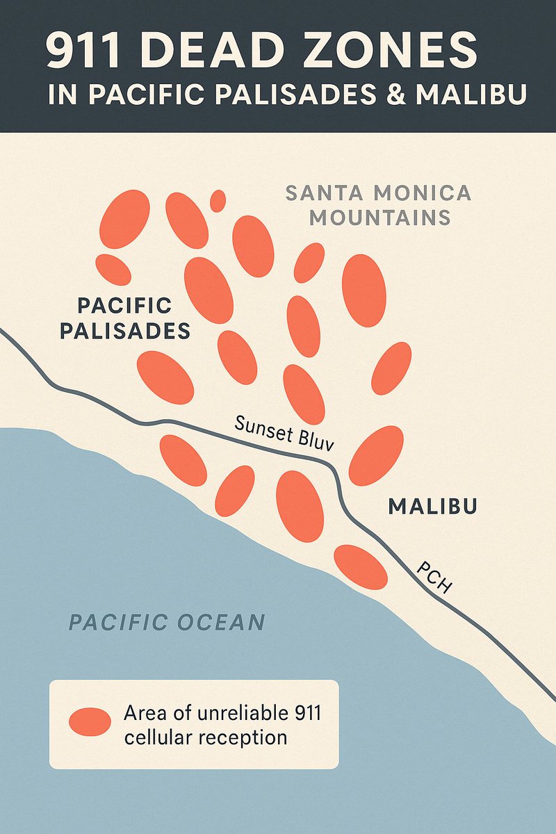
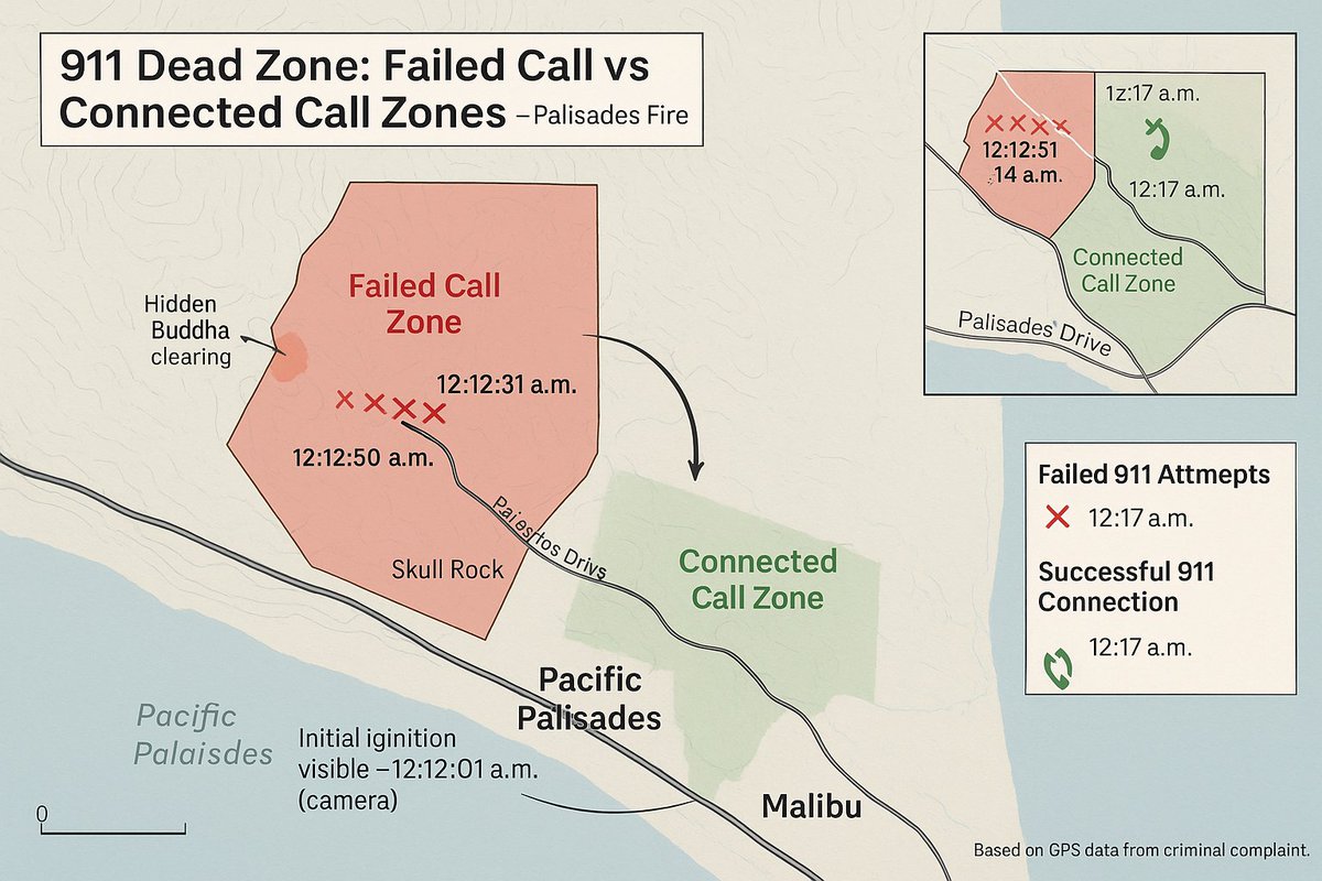
If the Palisades Fire Call Wasn’t in a Dead Zone — Could It Have Been Stopped? deadzones.com/2025/10/if-pal…
3
4
86
Disaster Relief Maps retweeted
8 Oct 2025
"He is charged with starting a fire on Jan. 1," Acting U.S. Attorney Bill Essayli said. "It did take a week to reignite, but he is charged with starting the Palisades Fire." deadzones.com/2025/10/if-pal…
2
3
88
Disaster Relief Maps retweeted

6 Oct 2025
🚨#BREAKING: Officials with the National Weather Service have confirmed the nation’s first EF-5 tornado in over a decade.
📌#Enderlin | #NorthDakota
Officials with the National Weather Service have confirmed the nation’s first EF-5 tornado in more than a decade. After 4,414 days, the NWS has officially upgraded the June 20, 2025, Enderlin, North Dakota tornado to an extremely powerful EF-5, the highest classification on the Enhanced Fujita Scale, with estimated wind speeds exceeding 200 mph. And resulting in three lives. This marks the first EF-5 tornado since the catastrophic Moore, Oklahoma storm on May 20, 2013, which was more than a mile wide and claimed 24 lives The announcement has stunned meteorologists nationwide, with experts calling the Enderlin tornado one of the strongest ever recorded across the Northern Plains.
1,029
6,105
50,981
4,292,052
23 Sep 2025
Typhoon Ragasa: Tracking, Impact & Preparedness Guide disasterreliefmaps.com/2025/… @RSOE_EDIS
2
2
82
Disaster Relief Maps retweeted

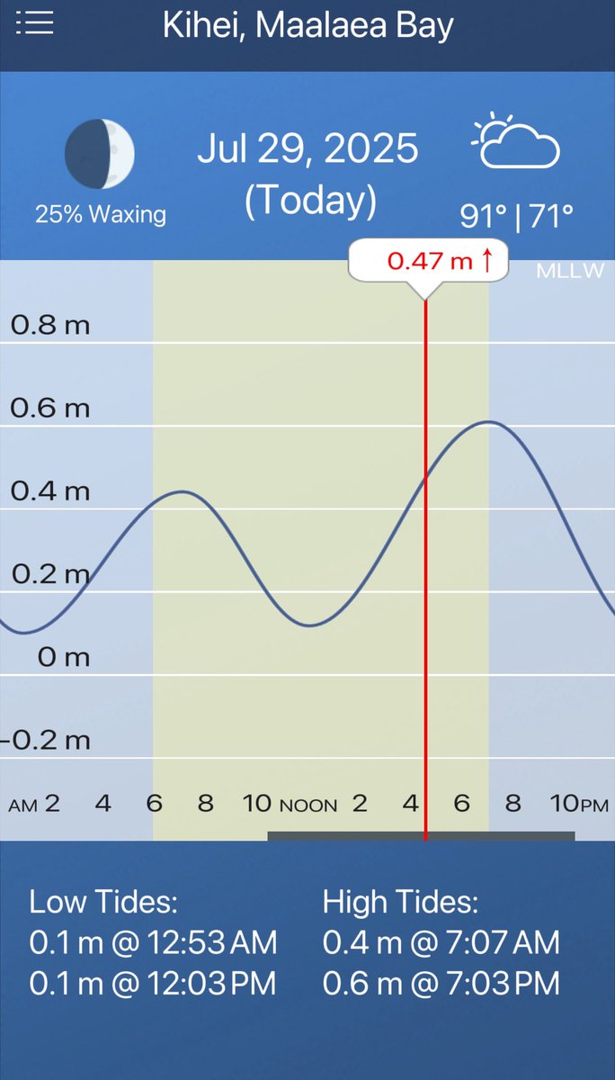
30 Jul 2025
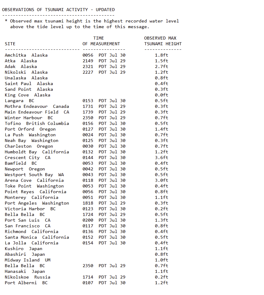
Tsunami wave of 3.6 feet observed in Crescent City, California, and 3.0 feet observed in Arena Cove, California
(from NWS)
12
74
237
28,847
Disaster Relief Maps retweeted
30 Jul 2025
Some west coast US tsunami measurements (so far), from National Weather Service
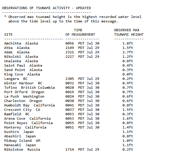
6
24
115
18,788
Disaster Relief Maps retweeted

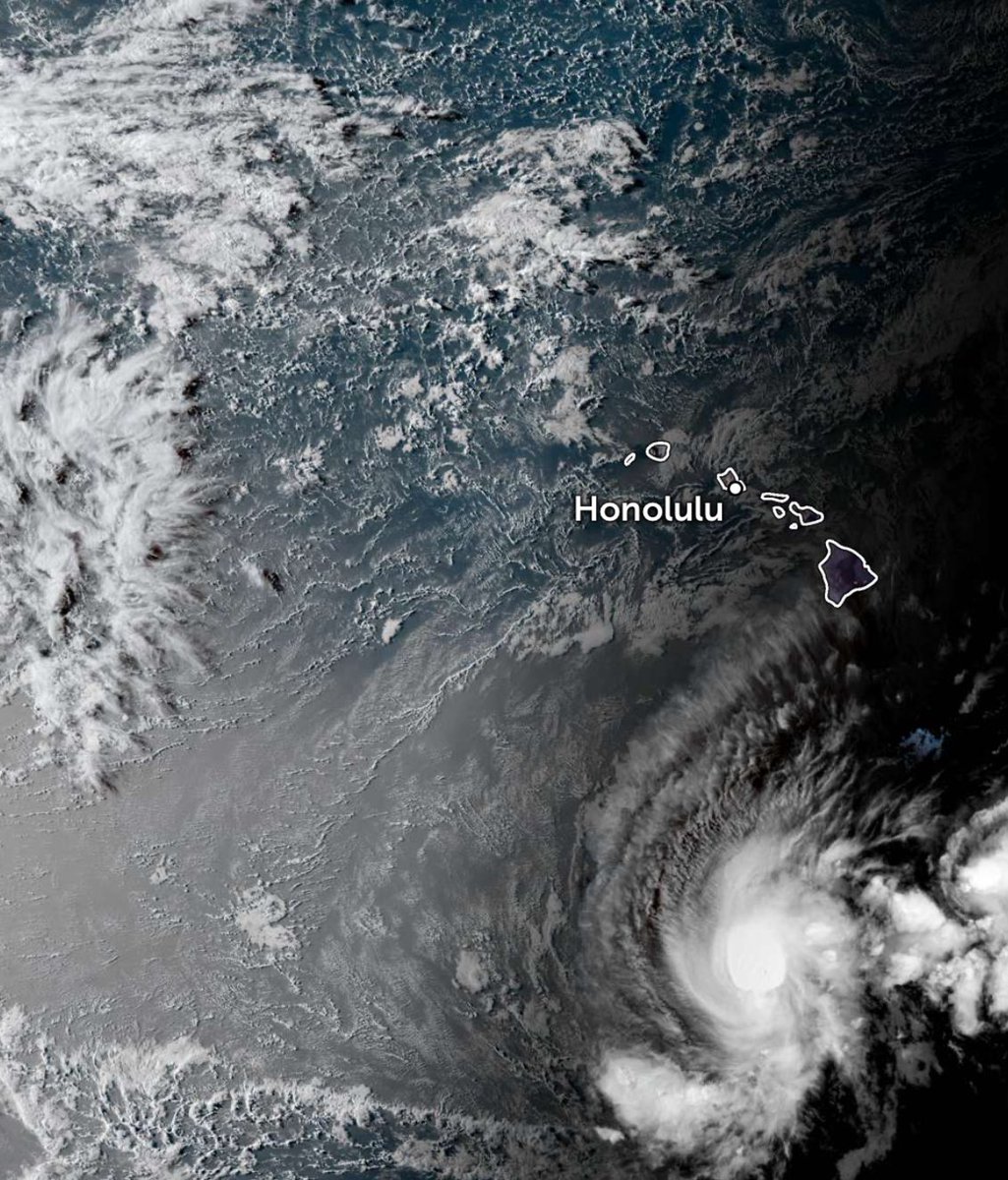
30 Jul 2025
Something very rare is about occur in the Pacific Ocean. In just a few hours, a tsunami will be passing right underneath a major hurricane. Can’t recall ever seeing this before.
389
4,764
24,496
2,388,893
Disaster Relief Maps retweeted
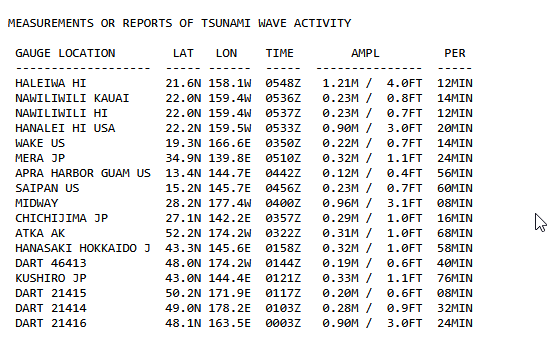
30 Jul 2025
Some new Hawaii tsunami measurements from National Weather Service, a 4-foot wave has been reported (some other places here as well)
24
107
319
55,599
30 Jul 2025
1
188
Disaster Relief Maps retweeted
30 Jul 2025
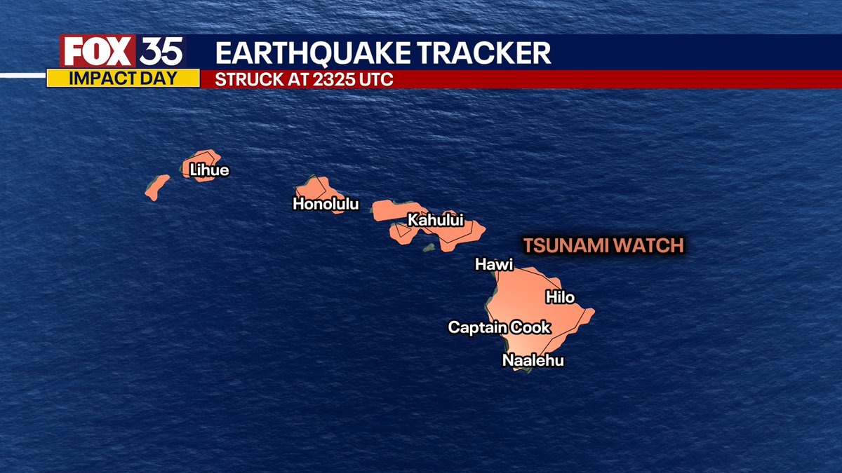
🚨#BREAKING: Tsunami sirens are now blasting across Hawaii after warnings were issued. Thousands are evacuating to higher ground as waves between 3 to 12 feet above tide level are possible. The USGS has just upgraded the Pacific earthquake to a massive magnitude 8.8.
350
3,912
14,986
2,184,532
30 Jul 2025
Tsunami Warning - 8.7 Earthquake Near Russia #video #earthquake #Tsunami
disasterreliefmaps.com/2025/…
284

Tsunami simulator shows the potential waves that could reach the US West Coast
Community note
This simulation video is from the 2011 Tōhoku earthquake and tsunami. As it can be seen from the bottom left corner, the video is from 2012.
en.wikipedia.org/wiki/2011_T�…
555
2,508
10,434
6,558,267
30 Jul 2025
165
Disaster Relief Maps retweeted

30 Jul 2025
Pacific Tsunami Warning Center extended the TSUNAMI WATCH for Hawai‘i. Magnitude of earthquake has been revised from 8.0 to 8.7. Analysis continues on whether Hawaii is threatened. Earliest expected arrival time: 7:17 p.m. HST. More alerts will be issued as analysis continues.
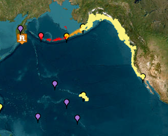
ALT Map shows earthquake location off Kamchatka coast. Hawaii and much of Alaska and North American West Coast are in Tsunami Watch. Parts of Aleutian Islands are in Tsunami Advisory or Tsunami Warning.
12
167
319
60,004
Disaster Relief Maps retweeted

30 Jul 2025
BREAKING: And I mean WOW this is huge. The quake was prelim. an 8.0 but upgraded now to a massive 8.7 magnitude. This struck minutes ago off the east coast of the Kamchatka Peninsula, Russia. This was a pretty shallow quake with depth of 19km (only 11 miles down). Tsunami Alerts are now active for all of Hawaii and the Alaskan Islands. A quake of this extreme intensity and shallowness can pose major tsunami risks. Tsunami alerts are expanding immediately around the Pacific Rim. Tsunami waves over 3 meters (10 feet) above normal tide levels are now possible along portions of the northwestern Hawaiian Islands and coastal areas of Russia.

50
674
2,412
381,802