
🇺🇸 East Texas Native • Meteorologist • Lindale Eagle | TJC Apache | SFA Lumberjack | MSU Bulldog • FB & Instagram: Doc Deason Weather
Joined September 2009
- Tweets 41,790
- Following 3,714
- Followers 4,004
- Likes 15,709
15,730 Photos and videos


12m
I've seen a still of this pass through my X feed for the last 24 hours, but I haven't had time to see what all the fuss was about. After about 22 seconds, I knew what all the fuss was about. That was EPIC. Whitney at the '91 SuperBowl kind of good. And, Maverick was there, too. 🇺🇸

21
44m
Preach.
Jun 13

Europeans visiting America for the World Cup are finally getting to experience our culture lol
63
Jun 13
LIVE from TEXAS. Historic.

121


Jun 12
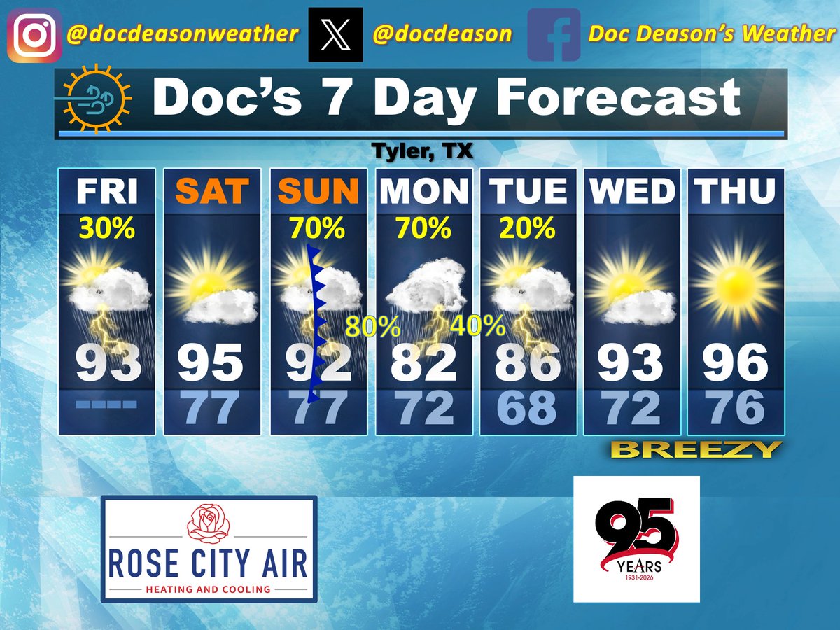
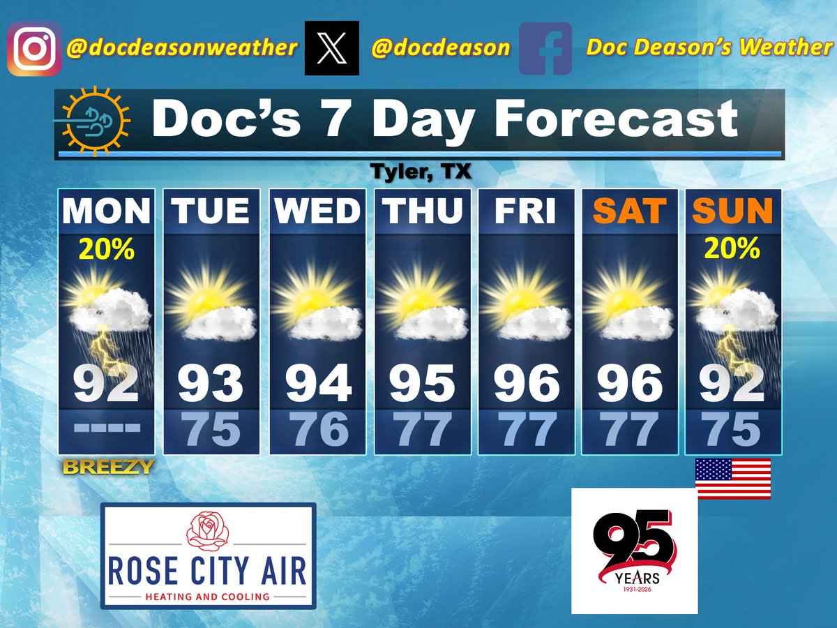
FRIDAY MORNING WEATHER
(Powered By: Rose City Air & Altra Federal Credit Union - Texas)
Good Friday morning, and welcome (almost) to the second weekend of June! Clouds are a large part of the morning once again as we continue with a decent fetch off the Gulf this morning. In addition, we have a cluster of showers and thunderstorms along the Red River, thanks to a nearly stalled cold front that’s not expected to make too much further southward progress. This is the same situation I alluded to in yesterday’s update for our northern counties. While these showers and storms are expected to lose more of their composure through the morning, their presence and the potential for some additional southward movement by them will necessitate at least a chance for rainfall along and north of I-20 today. Chances will increase as you move further to the north.
• We’ll see a mix of clouds and sun through the day, which will allow for temps to still make a decent bump upward. This, combined with dew points in the juicy mid-70s, will result in Heat Index values above the 100° mark again today.
• Any showers still out there this evening will fall apart after dark, and we’ll be left with another very warm night.
• A little more pronounced ridging on Saturday should help to quell the rainfall chances and should also boost our temps by a few degrees over what we’ll see today.
• Following another increase in clouds on Saturday night/early Sunday, another cold front will make a run at and through the area on Sunday. This front will have much better support aloft, too, which should result in much better shower and thunderstorm chances on Sunday afternoon and Sunday night.
• The Weather Prediction Center has some highlighted areas of potential heavy rainfall and flooding potential across East Texas on both Sunday and Monday. So, while the ground is still pretty dry, the potential heavy downpours from the high moisture content, especially over urban areas, could be a nuisance during that window of time.
• It looks like we’ll start the week with additional decent shower and thunderstorm chances on Monday before those start to wane on Monday night and especially Tuesday.
• Ridging should quickly take back over by mid-week, and that will mean dry and much warmer temps areawide.
• On this date in 1940, excavation work began on what would later become known as Mike Carter (Baseball) Field in Tyler.
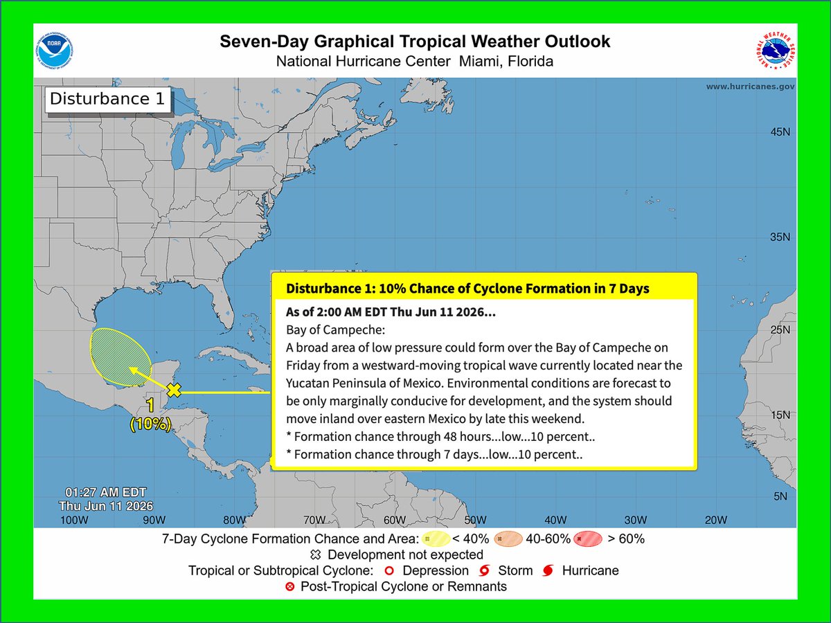
• Tropical Update: The National Hurricane Center continues eyeing an area of disturbed weather over the SE Bay of Campeche this morning. This will continue moving northwest and should eventually come ashore just south of the Texas/Mexico border later this weekend. There are still some models trying to take it northeast along the Texas coast, which would help further with additional rainfall across that area, but that is still up for debate. Regardless, nothing significant insofar as development should occur with that system.
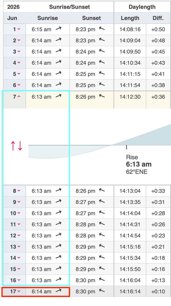
☀️ Today • Sunrise: 6:13 am - Sunset: 8:28 pm | Total Daylight: 14:14 ( 0:23) ⎥ Tyler Normals: 71/90 – Records: 100°/2022 -- 51°/1979 – 1.74”/1945
📊 Lower 48 Temp Extremes for Thursday: 116° at Death Valley and at 16 miles southwest of Tecopa, California 🔹 14° at 14 miles west-southwest of Mackay, Idaho
• Thursday Climate Stats • Tyler City: 78/93 (0) -- Tyler Pounds: 78/94 (0) -- Longview: 78/95 (0) – Lufkin: 77/MM (0) #etxwx #txwx
4
207

Doc Deason retweeted

Jun 9
Hey Jasmine…
Black pilot here.
I think you missed the plot.
Then again, that’s becoming a pattern.
I graduated from West Point.
I went through Army flight school.
I learned to fly the AH-64 Apache.
I deployed to combat and flew 55 combat missions over Baghdad.
Nobody handed me a cockpit because of my skin color.
Nobody lowered the standards for me.
Nobody looked at me and said, “Let’s check a diversity box.”
That’s what people like you don’t seem to understand.
Suggesting that Black pilots, Black engineers, Black doctors, or Black leaders need special preferences to succeed is not empowering, it’s insulting.
I didn’t want a different standard.
I wanted the same standard.
And when you’re flying into combat, the American people don’t care what race the pilot is.
They care whether the pilot is qualified.
Merit isn’t racist.
Excellence isn’t discriminatory.
And reducing every achievement to skin color says far more about your worldview than it does about mine.
5,421
35,896
172,078
2,708,583
Jun 11
This is so well said by someone who brings credibility from a completely different realm of the culture. I was telling a friend just yesterday that this California fiasco being allowed to occur on its own, without other competing election distractions, puts a LOT of light onto a subject that might otherwise be missed by many who don't necessarily follow these kinds of things as closely. But anyone with eyes to see can plainly focus on what's going on with those mail-in ballots, and it's dangerous, because it casts doubt on EVERYTHING in that state.
Jun 10

💥NEW: Jillian Michaels: “I gotta be honest: it seems to me that Trump is the ONLY one standing between US and the COMPLETE loss of free and fair elections.”
“You know, I used to think that Trump was INSANE for suggesting that the 2020 election was stolen. And now, I’m just — I’m actually not so sure.”
“Because these ANIMALS in California are not just changing election law — they’re changing what elections actually ARE!”
1
3
106
Jun 11
Amazing!!
Jun 11

Sepsis kills more people in American hospitals than heart attacks. 350,000 deaths a year, and the reason is brutally simple: the early warning signs are almost invisible.
A slightly elevated heart rate. A small temperature shift. A lab value drifting in the wrong direction. Each one looks like noise on a busy ward. By the time the pattern is obvious to a human, the patient is hours into a cascade toward organ failure, and every hour of delayed antibiotics raises mortality.
Tampa General built a system on Palantir's Foundry that watches roughly 1,000 inpatients continuously. Vitals, labs, medication records, clinician notes, all scanned in real time for the pattern no single nurse can see across 12 beds at 3am. When risk crosses a threshold, a rapid response team gets paged. Humans still make every treatment decision. The software just compresses detection from hours to minutes.
The results since 2022: overall sepsis mortality cut in half, 48-hour deaths down 68%, length of stay down 30%, roughly 900 lives saved. At one hospital.
Now run the national math. There are about 6,100 hospitals in the US. If even the 500 largest matched these numbers, you'd be looking at tens of thousands of lives a year from a single use case. The treatment for sepsis hasn't changed. Antibiotics and fluids, same as decades ago. The entire gain comes from starting them earlier.
The hardest problem in medicine was never the cure. It was noticing in time.
1
1
103
Jun 11
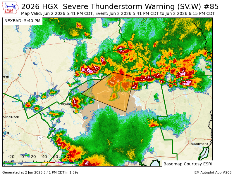
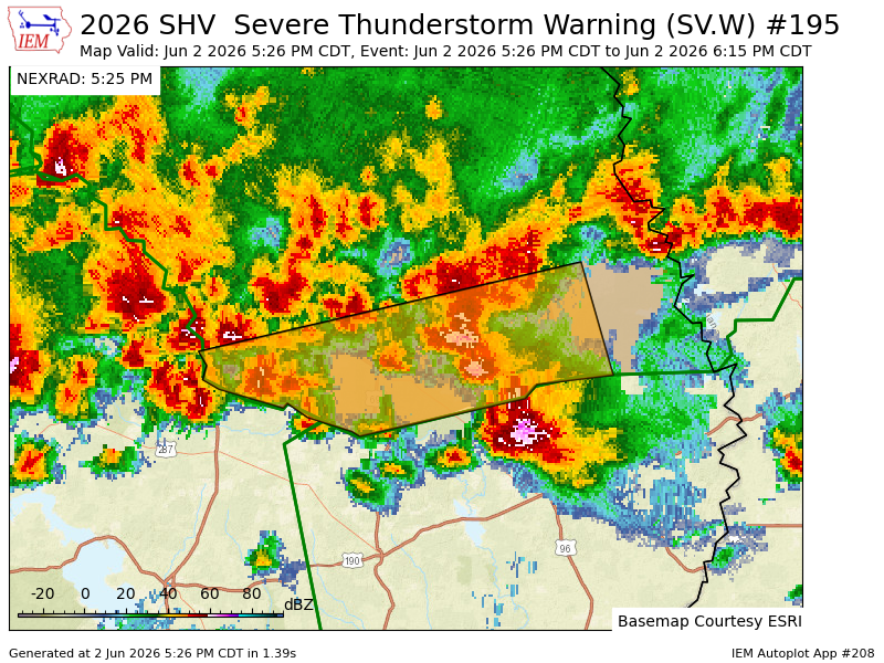
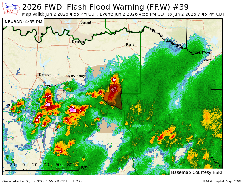
Here's the area that NHC is watching for some potential weak organization over the next day or two. While not expected to turn into some type of tropical beast, its track does have implications on rainfall potential along the Texas Coast over the weekend and into early next week. There are some models trying to take it more northeast, as opposed to more directly into Mexico. #etxwx #txwx
114
Jun 11
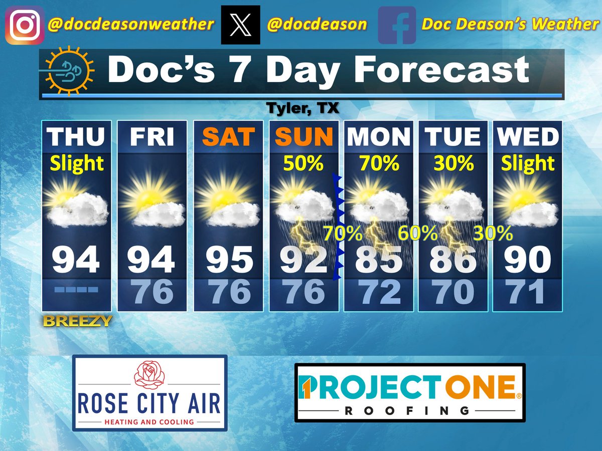
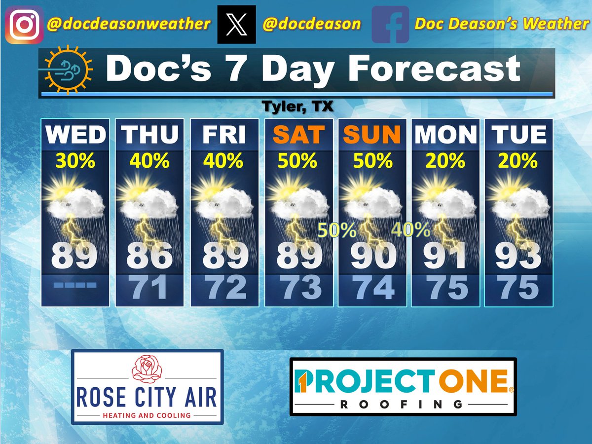
THURSDAY MORNING WEATHER
(Powered By: Rose City Air & Project One Roofing)
Good Thursday morning, and welcome to the 11th day of June! To nobody’s surprise, we’re greeted outdoors with a lot of low cloud cover to start the day. The clouds can’t help but be helped along by the good breeze we have at the surface, which is even more pronounced because of the 25-30 mph winds we have a thousand or so feet aloft over the area. And, as was the case yesterday, precipitable water values remain quite high across our part of the country, too.
• We will remain at least breezy at times again today, thankfully. And, while there are plenty of breaks in the clouds at the time of this writing, I think we’ll still be left with a mix of clouds and sun throughout the day. Short-term models show a smattering of weak shower returns across the area as we go through the day, too, which, after yesterday’s performance, I don’t think should be completely ignored, even though amounts around the area were quite light. But, given the high moisture content, wind profile, and strong heating, I feel better about leaving a low-end chance in there to cover our bases.
• Tonight should be another quiet one for most of us, although our I-30 counties will need to be on the lookout for some decaying showers and thunderstorms that could migrate southward into the area after midnight. Otherwise, it’ll just be warm and humid.
• Another rinse and repeat day looks to be in play for Friday as morning clouds give way to what should be a little better sunshine on Friday afternoon with temps running low to mid-90s in most spots by day’s end.
• The passage of a system to our north on Friday, which is what will help with those showers and storms across the northern counties tonight and early on Friday, should allow for a corresponding warmup on Saturday in its wake.
• Our next system, which is nice to be able to talk about this deep into the month of June, will approach on Sunday and should have a cold front in tow. That will result in increased shower and thunderstorm chances by Sunday afternoon across the area, with those chances increasing further as we get into Sunday night & Monday. As you can already tell from what we’ve currently got going on, we’ll have a lot of moisture to play into those incoming dynamics, and that should allow for some healthy rainfall totals through that Sunday afternoon and Monday window.
• Look for some chances to linger into Tuesday and Wednesday to a lesser degree, with temps also being affected by the presence of rain and the lack thereof by Wednesday.
• The weekly Drought Monitor will be released later this morning and, like last week, should show that we really could use a good dose of soaking rain.
• Tropical Update: NHC is eying an area along the Yucatan Peninsula for possible development once it gets over the Bay of Campeche, tomorrow. This will be something to watch for potential impacts across Deep South Texas as we go over the weekend. In fact, there are some models that try to slice this thing back to the northeast, instead of taking it into Mexico, which would have implications regarding more enhanced rainfall potential along the Texas Coast. More on this as we move forward today and tomorrow.
☀️ Today • Sunrise: 6:13 am - Sunset: 8:28pm | Total Daylight: 14:14 ( 0:26) ⎥ Tyler Normals: 71/90 – Records: 103°/1911 -- 52°/1955 – 3.03”/1995
📊 Lower 48 Temp Extremes for Wednesday: 114° at 16 miles southwest of Tecopa, California 🔹 16° at 14 miles west-southwest of Mackay, Idaho
• Wednesday Climate Stats • Tyler City: 77/91 (T) -- Tyler Pounds: 77/92 (T) -- Longview: 76/94 (0) – Lufkin: 77/93 (T) #etxwx #txwx
2
237
Doc Deason retweeted

Jun 11
One of the coolest jobs out there!
This is a towbarless aircraft tractor it grabs the aircraft’s nose gear and moves thousands of pounds like it’s nothing.
📹: ikyav_wings
65
476
4,975
725,800
Jun 11
Ha! Well said.
Jun 11

True ... the climate crisis is truly man-made -- using data tampering.

2
123
Doc Deason retweeted

Jun 11
Challenge Accepted! Jack of Omaha, Nebraska has stepped up to make a difference and accepting our 50 yard challenge , committing to mow 50 free yards for those in need in his community. This is what it’s all about. Welcome to the family, Jack!

80
355
2,840
11,592
Jun 11
Child: "Daddy, what kind of music is that? It's so aggressive. And, where's Taylor?"
Father: "Sweetie, that's Rock-n-Roll. Those guys are each playing an instrument at the highest levels of their craft. It was an amazing time. And, I still don't know WHY that musical genre was wiped from pop culture in about 2020, and your generation was robbed in the process. I'll never understand that."

1
127
Jun 11
What a good dude.
Jun 11

Oh my gosh. Brandon Nimmo hits a 107 mph liner back up the middle, hits Lugo in the head, pretty solidly. Nimmo, friends with Lugo, was stunned and concerned about his friend coming out of the box. Lugo appears OK. But reaction also gives some insight to Nimmo:
143
Doc Deason retweeted

Jun 10
There is no climate crisis.
It’s all a scam.
1
8
168
824
Jun 11
I'm still gonna need some insight as to WHY we let this guy get away from the @Rangers.

Big milestone for a Texas Rangers world champion. 👀
112
Doc Deason retweeted

Jun 10
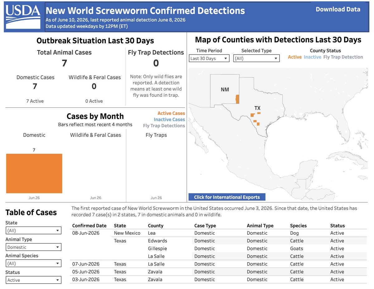
NWS SPREADING: Another Texas county has a confirmed case of New World Screwworm according to the @USDA's dashboard.
Edwards County had a cow infested with screwworm, bringing the national total to 7 cases across 5 counties in Texas and New Mexico.
37
568
860
73,105