
A new source of global weather information, and a new, welcoming weather community! Founded by @AlanSevere, join our discord! discord.gg/Ykygc8fuzK
Joined November 2024
- Tweets 1,901
- Following 28
- Followers 482
- Likes 304
1,586 Photos and videos


Apr 12
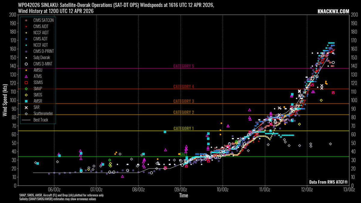
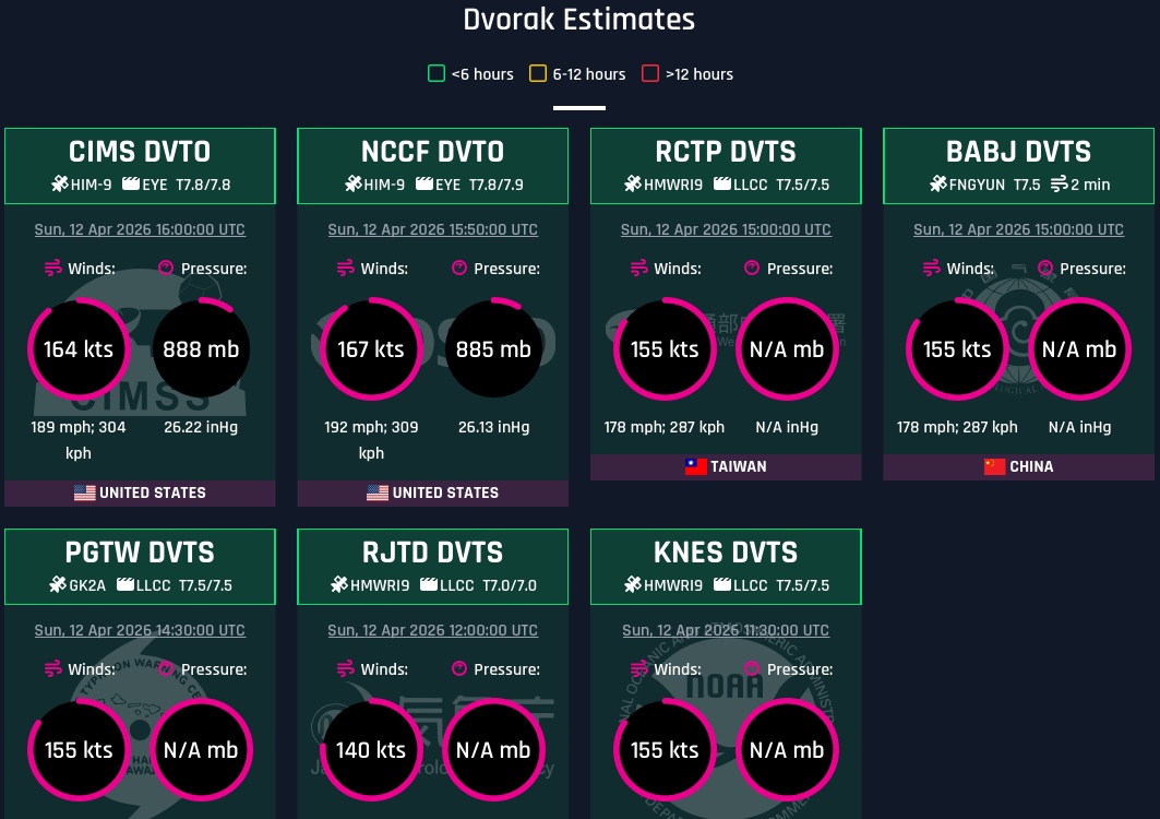
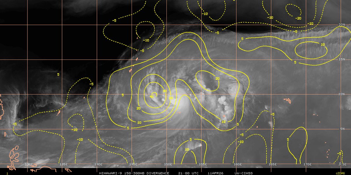
Super Typhoon Sinlaku underwent an unprecedented and explosive rapid intensification phase for April overnight, jumping from 120 kt to 155–160 kt (140 mph to 180–185 mph) in just 12 hours. This was supported by a blend of T7.5 subjective Dvorak estimates and the storm’s structural appearance. The system is now stronger than the JTWC’s current 150 kt (170 mph) analysis as of 12Z. JTWC’s analysis, dare I say, has been abysmal throughout Sinlaku’s rapid intensification period—bordering on reckless—given that it is being provided to the National Weather Service office in Guam, which is responsible for informing local residents.
The typhoon is likely hovering at or near peak intensity, with the central dense overcast (CDO) beginning to sustain and symmetrize. There are also signs that an eyewall replacement cycle may begin later today.
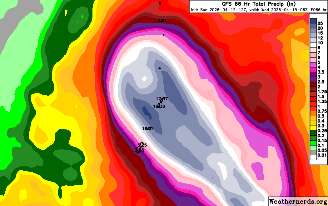
The latest forecast has shifted Sinlaku slightly farther north than expected, with guidance now pointing toward a very close graze or direct landfall over Saipan. Rainfall amounts are forecast to remain very high, exceeding 400 mm (15.75 in) across the Mariana Islands.
This will be a dangerous typhoon for the Mariana Islands. It is one of the strongest Pacific typhoons on record for the month of April, particularly for this part of the Mariana Islands.
1
4
16
865
Apr 12
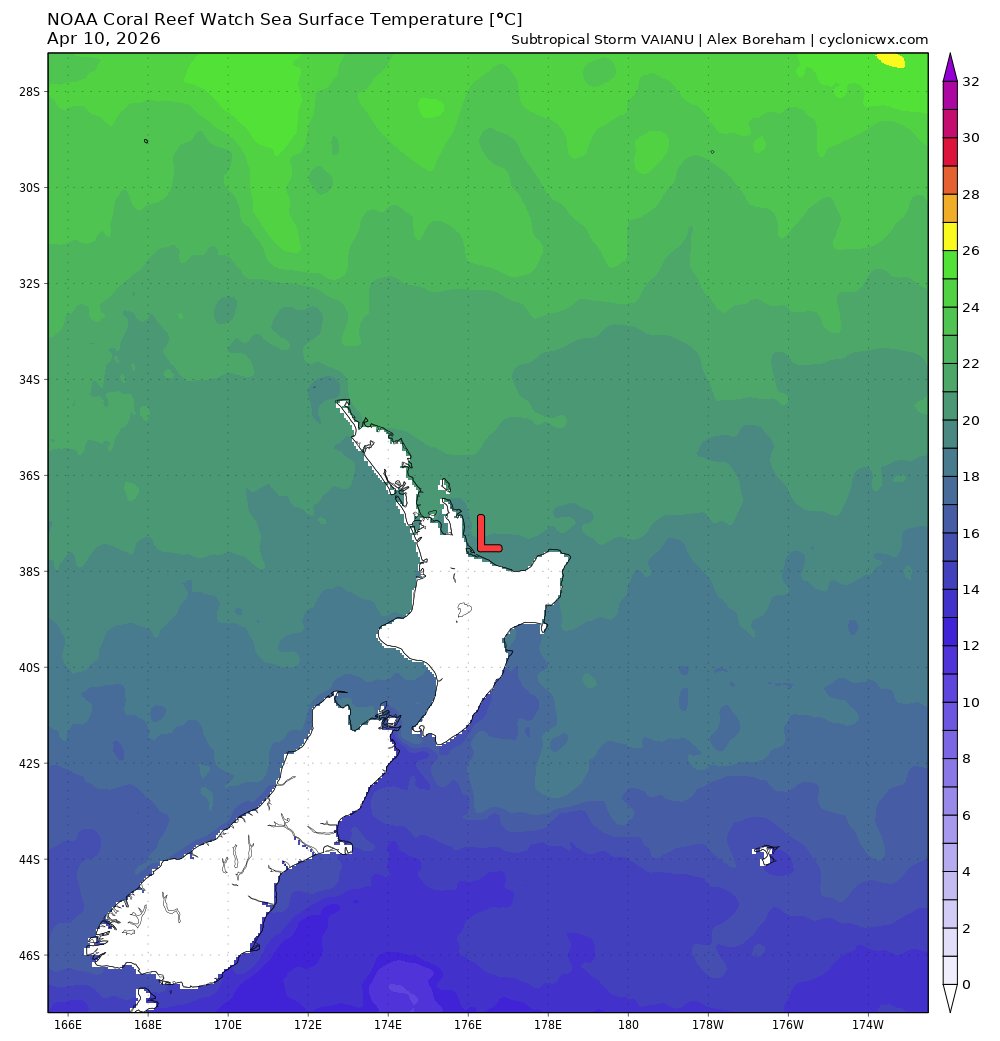
For the first time in recorded history, a tropical cyclone has made landfall in New Zealand. Tropical Storm Vaianu made landfall in Pukehina, North Island, New Zealand on April 12 near 02:00 UTC, with 1-minute sustained winds of 60 kt (70 mph/110 kph) unofficially. Despite cold sea surface temperatures of 19°C, the storm has been situated under an upper-level trough that is responsible for creating instability and convection. In addition, the storm has maintained a deep warm core south of 35 degrees, which is impressive at such a high latitude in the South Pacific.
Severe wind gusts of up to 75 kt (85 mph/140 kph) are still possible in the North Island as the storm accelerates south. Residents in the North Island should remain in shelter due to strong winds and flooding. Such winds can break tree limbs, uproot trees, and cause widespread power outages. Stay safe, everyone!
3
11
44
1,962
Apr 12
Typhoon Sinlaku, after days of anticipation, has now gone into full gear with a rapid intensification phase that began yesterday afternoon. The intense storm currently sits at roughly 115–120 kt as of 00:40 UTC, with current subjective and objective agency fixes lagging significantly behind — showing only a cumulative average of T5.5 (102 kt).
Sinlaku is currently embedded in an environment of moderate mid-level southeasterly wind shear originating from an upper-level trough associated with the jet stream. However, significant divergence aloft has virtually rendered this wind shear nonexistent, as a strong poleward outflow channel is diverting the shear away from the typhoon’s inner core.
The typhoon will continue to intensify and could achieve super typhoon intensity or stronger (>130 kt) before slamming into the Mariana Islands. Beyond that, Sinlaku will begin to recurve to the northeast before undergoing extratropical transition (ETT).
The entire Mariana Islands should be on high alert for this storm, as it represents the biggest threat to the islands since Super Typhoon Mawar (Betty) in 2023. NWS Guam has issued Typhoon Watches from Guam up to Saipan, stating that residents should begin finalizing their preparedness according to their typhoon disaster plans and start taking action. Heavy and likely destructive winds and rainfall are a guarantee; the typhoon may bring more than 500 mm (19.69 in) of rainfall from Guam to Saipan.
4
18
760
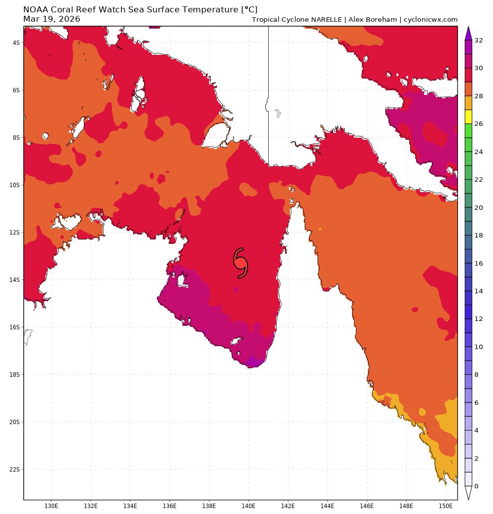
After nearly 900 days, the remarkable streak of the South Pacific not producing a major cyclone on the Saffir-Simpson Hurricane Wind Scale (SSHWS) has come to a close. The South Pacific has finally generated a major cyclone on April 7th at 0z. Cyclone Vaianu has intensified to a Category 3 major cyclone with 1-minute sustained winds of 100 kt (115 mph/185 kph). The Joint Typhoon Warning Center (JTWC) also upgraded Vaianu with winds of 100 kt. The JTWC fixed T 5.5 at 0z. The last major cyclone before Vaianu was Category 4 Cyclone Lola in October 2023.
An earlier microwave image from WSFM indicated Vaianu was almost done with its eyewall replacement cycle (EWRC) about 8 hours ago. Given the recent improvements in infrared and Dvorak imagery, Vaianu has completed its EWRC. The cyclone is expected to continue intensifying on Tuesday and may reach Category 4 intensity on the SSHWS. The storm is located in warm sea surface temperatures of 28-29°C and is in a relatively favorable jet interaction with moderately strong poleward outflow. However, its window for intensification is closing soon as the jet interaction turns unfavorable. The exact timing of Vaianu moving into an unfavorable environment is uncertain, but likely on Tuesday or Wednesday.
Vaianu is located west of Suva, the capital of Fiji, and the storm's rainbands have brought widespread flooding across the country. Residents should remain in their shelters. After peaking, Vaianu will head southward and weaken due to strong wind shear and cooler sea surface temperatures. The storm will then transition into a post-tropical cyclone north of New Zealand by the end of this week. Residents in the North Island should watch out for strong wind gusts, rough surf, squally showers, and potential flash flooding this Saturday. Stay safe, everyone!

6
19
1,070
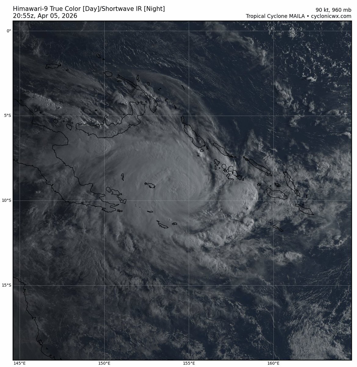
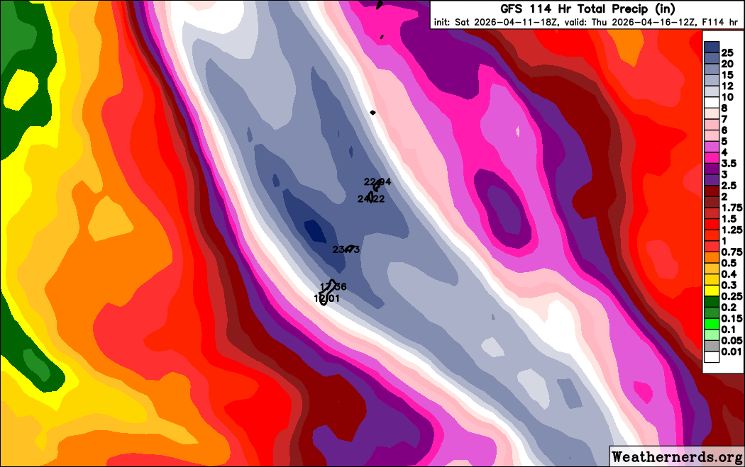
Cyclone Maila, the first storm named by the Papua New Guinea National Weather Service (PNGNWS) in over 18 years and the strongest tropical cyclone on record in the Papua New Guinea area of responsibility, is currently analyzed at 90-95 knots (105-110 mph). This intensity is supported by the T5.0 subjective Dvorak fix from PGTW at 20z. Maila is currently stalling in the northern Coral Sea, benefiting from high ocean heat content (OHC) that continues to fuel its rapid intensification phase. The system is expected to reach Category 3 status and possibly Category 4, provided moderate to high mid-level wind shear does not impede further intensification. Earlier today, this shear was observed disrupting the wrapping of vortical hot towers (VHTs).
This stalling motion is the result of a near-equatorial ridge (NER) positioned to the north of Maila and a subtropical ridge (STR) to its south over Australia. Consequently, excessive and potentially catastrophic rainfall is expected over the Conflict Islands of Papua New Guinea, with some areas possibly receiving upwards of 500 mm (19.69 in) of rain.
As the subtropical ridge dips southeastward, Maila will begin tracking west-southwest toward a possible landfall on mainland Papua New Guinea and later in the Cape York Peninsula — the same region impacted by Cyclone Narelle just over a week ago. There is also a possibility of regeneration once the system moves over the Gulf of Carpentaria. This scenario is supported by the GFS model, in contrast to the ECMWF (Euro) model, which depicts the system weakening over inland Queensland following landfall in Cape York.
5
8
804
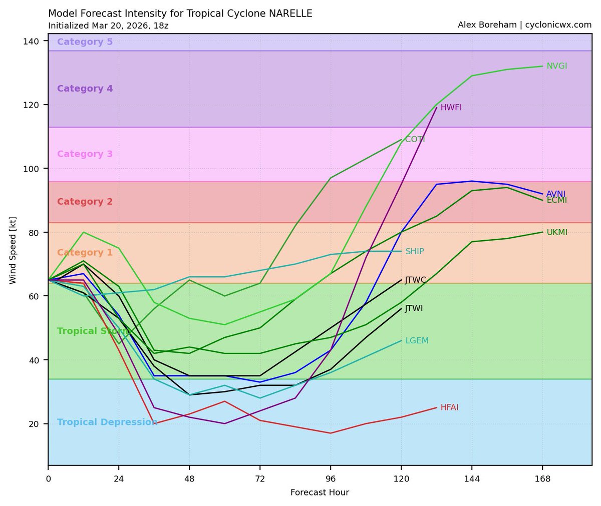
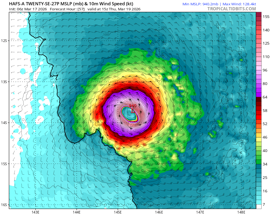
Mar 21
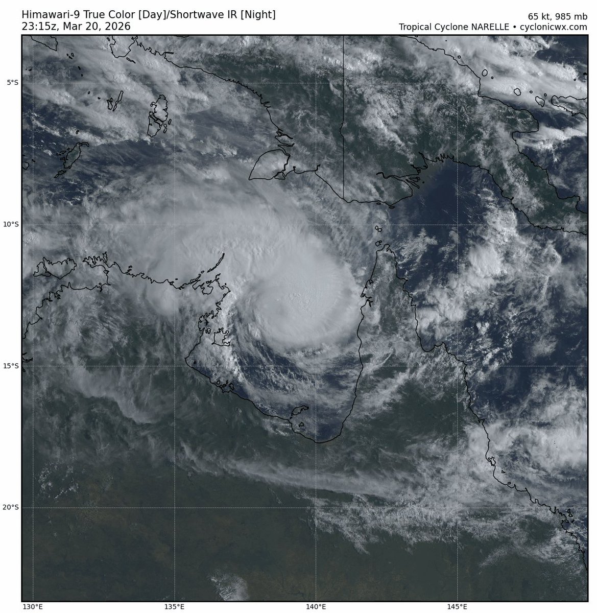
After peaking as a high-end Category 4 hurricane—likely around 130–135 kt (150–155 mph)—Cyclone Narelle made landfall in northern Queensland as a Category 3 system with winds of 115 kt (130 mph). It weakened somewhat while crossing the mountainous terrain of the Cape York Peninsula, but it now appears to be strengthening again as it approaches the Gove Peninsula and prepares for a second landfall in the Gulf of Carpentaria (GOC).
A weak, nascent eye has developed as Narelle’s low- and mid-level centers gradually re-stack over sea surface temperatures of 29°C. Current Dvorak agency CI estimates at 00Z average around T4.2, corresponding to approximately 70 kt (80 mph). However, the system is currently experiencing moderate mid-level easterly shear, which is forecast to increase further before the upcoming Gulf landfall—meaning this secondary peak will likely be short-lived.
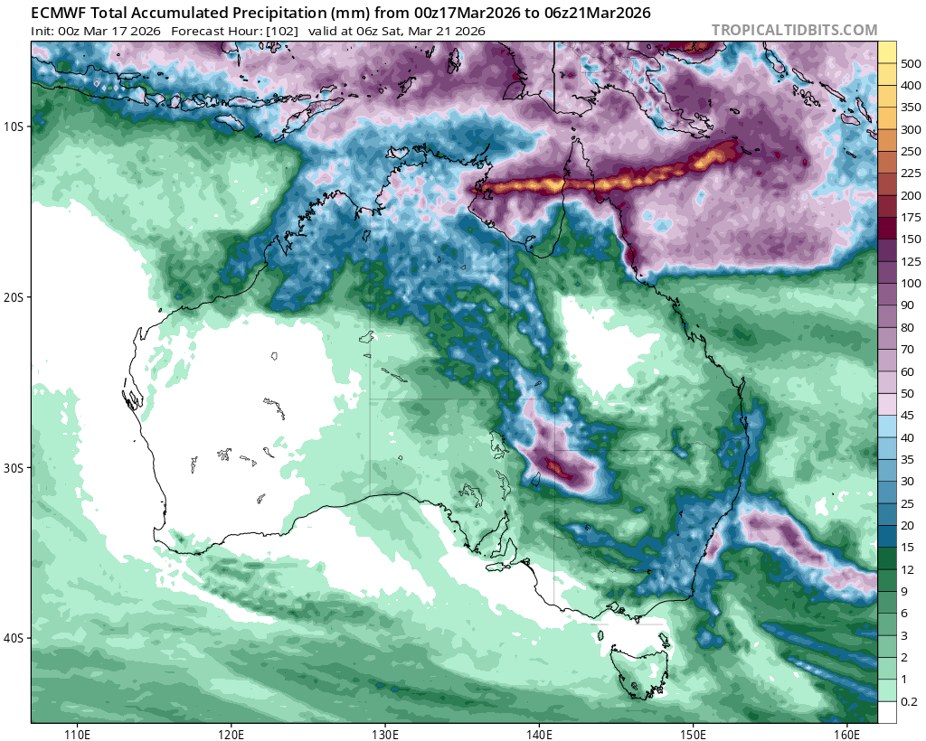
Once Narelle emerges into the Indian Ocean, conditions are expected to become favorable once again for another period of rapid intensification. Model guidance varies significantly regarding the ultimate peak intensity, with some solutions suggesting an even stronger maximum than the initial Category 4 peak observed yesterday. Regardless of the exact strength, Narelle is forecast to produce upwards of 175 mm of rainfall across the sparsely populated Northern Territory of Australia. This includes the territory’s capital, Darwin (population ~140,000), where the heavy rain will pose a significant flash flood risk.
2
4
14
932
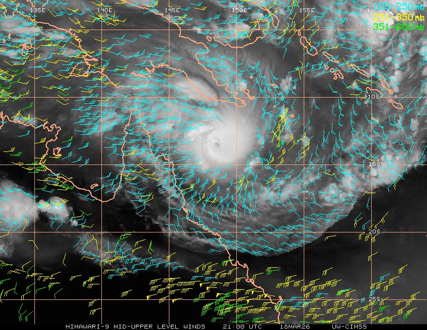
Mar 19
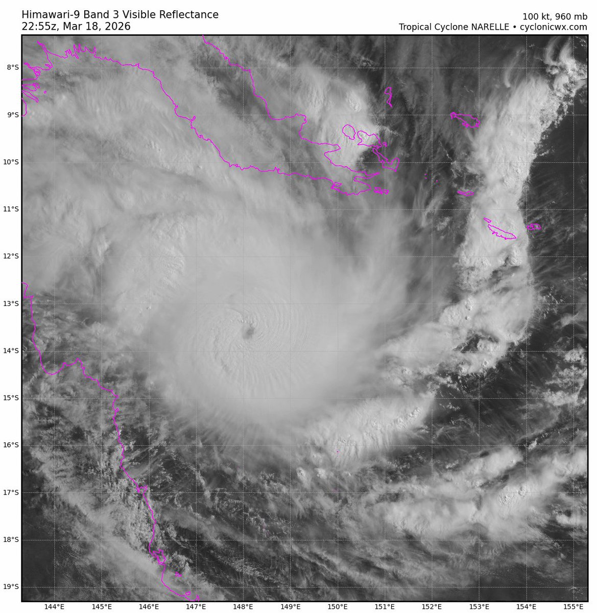
Cyclone Narelle has undergone a formidable explosive intensification phase over the Coral Sea, the Bureau of Meteorology has recently upgraded it to a Category 5 on their scale. Current Dvorak agency fixes range from T5.5 to T6.0; however, satellite presentation suggests it may already be closer to T6.5. Regardless of the exact subjective estimate, Narelle is likely sustaining winds around 120–125 kt (140–145 mph) as of 01Z.
The cyclone is expected to continue tracking west-southwest before making landfall over the Cape York Peninsula. Narelle will likely continue to rapidly intensify over the next few hours, supported by strong divergence aloft and well-established poleward and equatorward outflow channels. It may briefly breach Category 5 intensity before a short-term weakening occurs due to an increase in mid-level wind shear. However, intensification could resume shortly before the system approaches Cape York.
As noted, the Cape York Peninsula lies directly in Narelle’s path. Localized heavy rainfall could exceed 250 mm in some areas of central Cape York, such as the town of Coen, raising the risk of dangerous flash flooding. After landfall, Narelle is forecast to re-emerge over waters in the Gulf of Carpentaria, where it may achieve another peak intensity. It is then expected to move toward the Northern Territory coast for a second landfall, before eventually crossing into the Indian Ocean—potentially reaching yet another peak there!
7
14
918
Mar 17
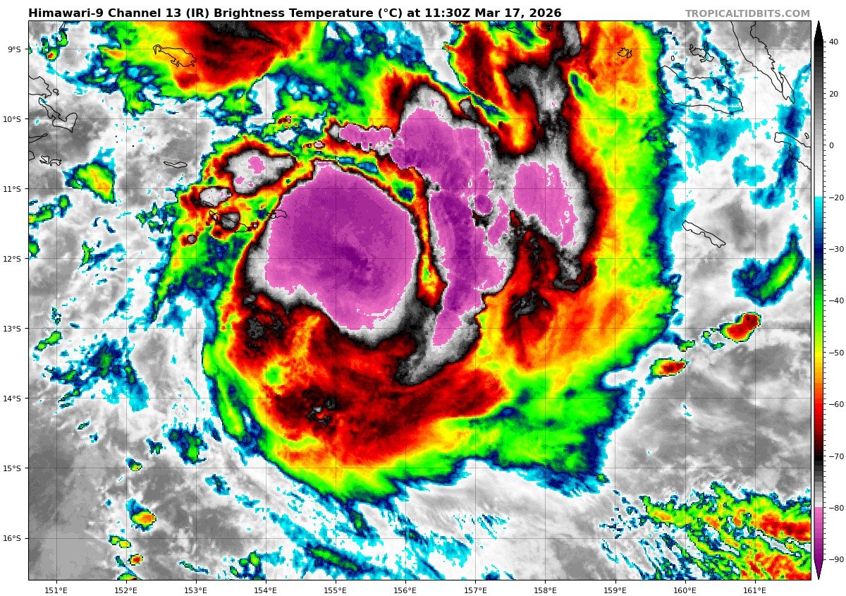
Tropical storm Narelle is quickly gaining strength in the Coral Sea this morning, most models show strengthen into a major cyclone as it approaches the northern tip of Australia.
This system will get pushed to the west by a high pressure to it's south. Which will put places like Coen at play for some dangerous conditions within the next 2-3 days. This includes high winds and flooding rains which could exceed 300 mm in some places.
4
14
1,029
Mar 16
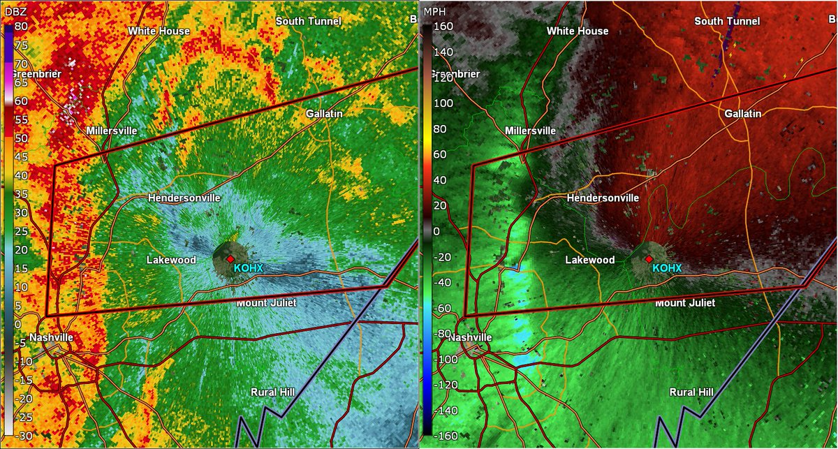
Tornado Warning for the NE Nashville Metro, including suburbs such as Lakewood and Hendersonville, TN. Multiple embedded circulations are being picked up via radar East of the I24-I65 interchange, and due to the presence of very strong wind shear across the region, these circulations may be able to spin up quick tornadoes within fairly populated areas.
Take cover immediately!
#TNwx #tornado
815
Mar 15
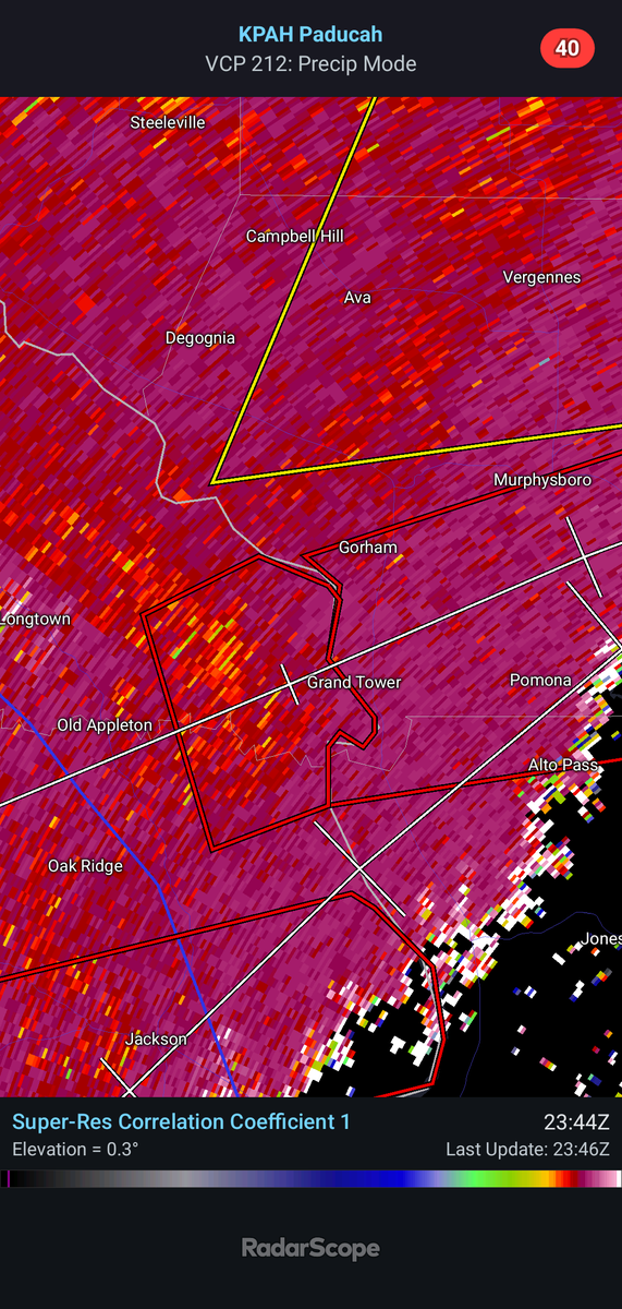
A tornado warning is in effect for areas including Grand Tower and Pomona. Radar indicates a possible tornado developing. Residents should immediately seek shelter!
1
127
Mar 15
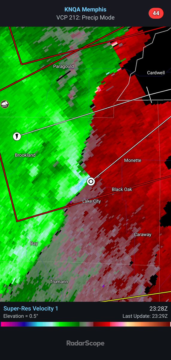
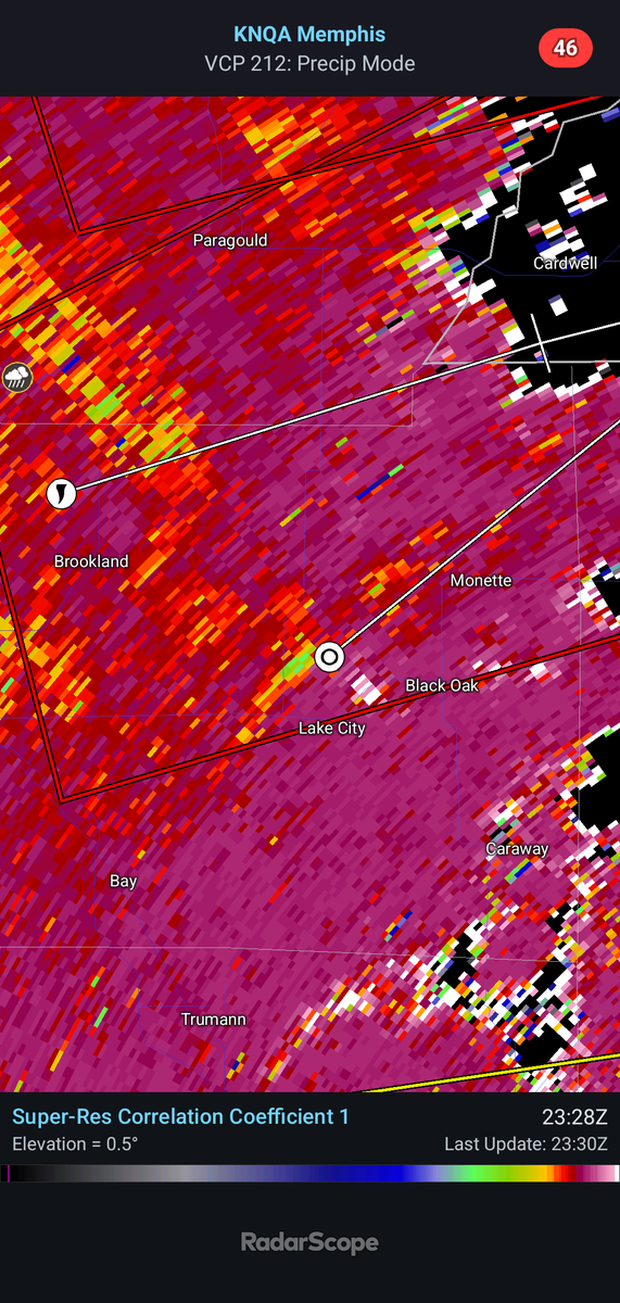
A tornado warning is in effect until 7:15 pm CDT near Lake City, Arkansas. There appears to be a CC drop on radar. This squall line has been capable of producing spin-up tornadoes. Residents near Lake City and Monette should immediately seek shelter!
1
2
156
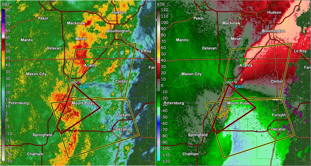
Mar 15
A likely tornadic squall line/QLCS is moving through the Lincoln, IL area, with multiple embedded mesovortex circulations present. These circulations could very shortly (or already may be), producing brief tornadoes at this time.
Take cover immediately if within the path of these dangerous storms!
#ILwx #tornado
1
74
Mar 15
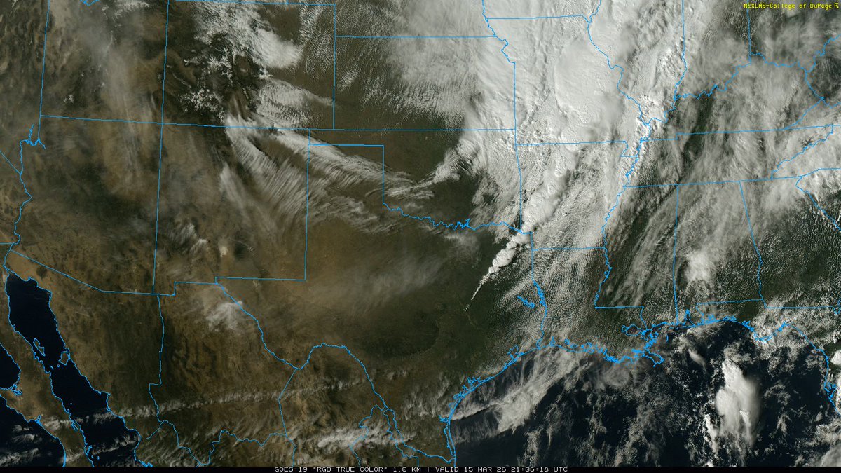
Along the severe risk that exists along/east of the cold front, behind it there is a major fire risk w/ several fires already reported across much of W Texas, New Mexico and Southern Oklahoma. Strong downsloping winds & post-frontal airmass have allowed for very dry conditions.
Note the wave of dust sweeping SW Texas and New Mexico on visible animation. This is helping rapidly reduce visibility in areas ahead.
1
260
Mar 15
A highly active quasi-linear convective system is progressing eastward near the Mississippi River along a sweeping cold front, amidst a surface low undergoing cyclogenesis further north.
An animated infrared loop through the meso sector shows the vigorous convective activity with peak cloud tops near -70C. Also note dense cumulus build-up just adjacent to the boundary with amplified moist advection, and the initiation of some semi-discrete cells in the open warm sector. These will need to be watched for potential significant tornadogenesis.
3
7
379
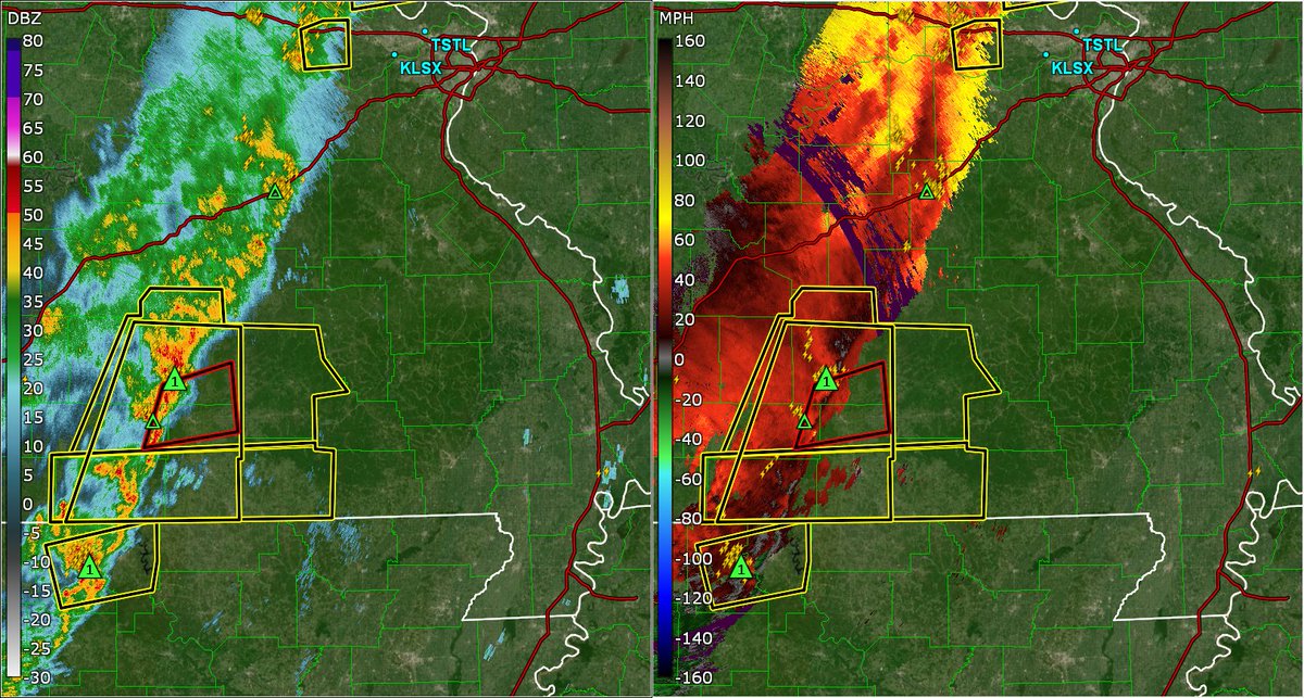
Mar 15
The entirety of the St. Louis Metropolitan Area, including the city of St. Louis proper, needs to be taking immediate tornado precautions and seeking a safe tornado shelter right now! An advancing line of severe thunderstorms with multiple embedded tornadic circulations is capable of producing brief spin-up tornadoes within the line itself, along with damaging wind gusts upwards of 60-70mph.
Given the very strong wind shear and fast motion speed of this squall line, these tornadoes (while being brief in nature), may be strong at times.
TAKE COVER NOW!
#MOwx #tornado
1
533
Mar 15
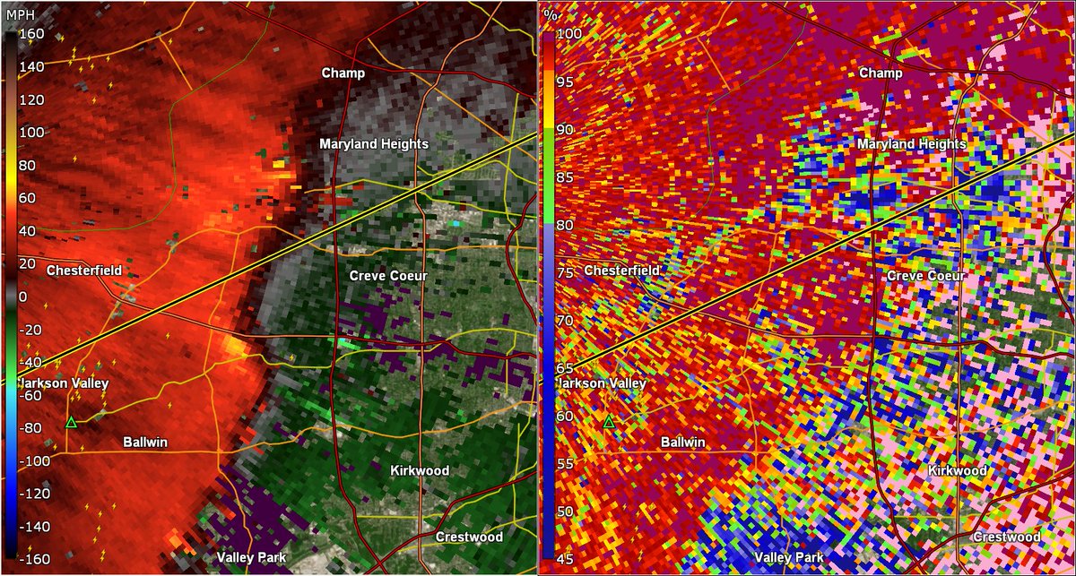
Two unwarned QLCS circulations are present to the SE of Chesterfield, Missouri within the St. Louis Metro. These circulations are relatively strong in nature and may be producing spin-up tornadoes at this time.
The strongest of the circulations, the one to the SW of Creve Coeur, likely has a weak debris signature evident, indicative of a tornado on the ground.
Residents in Creve Coeur, Maryland Heights and nearby vicinities within the Western STL metro need to be on high alert and preparing to take immediate tornado precautions should a tornado warning be issued! For those in the path of this possible weak tornado, you should be inside a safe tornado shelter until the storm passes as a precaution.
1
2
415
Forecast Frontier retweeted

Mar 15
A tornado watch has been issued for parts of Arkansas, Illinois, Indiana, Kentucky, Louisiana, Mississippi, Missouri and Tennessee until 11 PM CDT
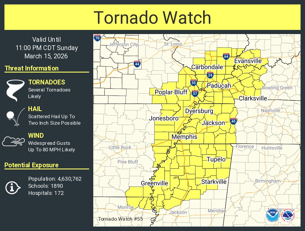
ALT This graphic displays Tornado Watch watch number 55 plotted on a map. The watch is in effect until 11:00 PM CDT. The watch includes parts of Arkansas, Illinois, Indiana, Kentucky, Louisiana, Mississippi, Missouri and Tennessee. The threats associated with this watch are several tornadoes likely, scattered hail up to two inch size possible and widespread gusts up to 80 mph likely. There are 4,630,762 people in the watch along with 1890 schools and 172 hospitals.
10
181
482
69,003
Mar 15
Interests within SE Missouri this afternoon should prepare to take the proper tornado/severe weather precautions over the next hour or so with an intensifying line of severe storms pushing from the West.
Due to the very high and strong wind shear across the region, the line will have the potential to produce several spinup tornadoes (some of which may be strong due to increasing speed of the line itself).
Regardless of if it's a severe thunderstorm or tornado warning today, treat any warning as if there is the potential for dangerous severe weather today, and make sure to take the proper precautions to stay safe!
2
4
406