
Discover geospatial datasets and tools, AI capabilities, and planetary-scale insights from Google Earth, Google Earth Engine and Google Maps Platform
Joined April 2009
- Tweets 4,137
- Following 285
- Followers 1,112,732
- Likes 2,874
1,054 Photos and videos


Jun 12
Prepare for takeoff. ✈️ Flight simulator is now available globally on web to all users. goo.gle/4fBYnWO
We've recently added many our most powerful professional desktop features to web. Elevation profiles, new import types, but there's always been one other feature you've been asking us to add to the web version of Google Earth, just for fun...
Where will you fly? Share your best maneuvers, views, and flyovers with us!
383
3,436
27,688
7,079,932
Jun 10
Conducting road safety audits, scheduling maintenance, or planning logistics routes used to require combing through imagery or, worse, driving miles of roads yourself. Not anymore. goo.gle/4omKDRZ
New AI-powered data layers in Google Earth are changing that. Pulling from billions of Google Street View images, these layers now spot infrastructure assets like stop signs, speed limit signs, and more to map infrastructure for you.
By combining these assets into a single project and diving into Street View you can locate and validate assets on Google Earth in seconds.
These layers are now available for Professional & Professional Advanced customers on web and Android, with coverage expanding over the coming weeks.
6
41
184
15,746
Jun 9
Alien landing on Earth? 👽 Spotted in downtown Manhattan 🏀
2
14
34
5,704
Jun 8
Acquiring foundational site details usually means traveling to sites, finding utility access points, and tracking down disparate data sources. Google Earth is changing the way professionals work. goo.gle/43P4mjJ
New AI-powered data layers in Google Earth pull from billions of Google Street View images to map infrastructure assets like fire hydrants, storm drains, and more. Plus, when combined with new building footprints and land parcels you have powerful, time-saving data a click away.
Inspecting utility access and site constraints from anywhere is now even easier with Google Earth.
These layers are now available for Professional & Professional Advanced customers on web and Android, with coverage expanding over the coming weeks.
4
30
286
74,393
Jun 2
Introducing new data layers for building footprints, land parcels, and AI powered layers that spot infrastructure assets from Street View imagery. Try these new layers now ➡️ goo.gle/4v53LXv
With information right at your fingertips you can spend less time combining data, manually identifying assets, and combing through imagery. These premium layers are now available for Professional & Professional Advanced customers on web and Android.
5
75
316
29,805
May 15
Support land management decisions from every angle. 🌍 goo.gle/42yeTPX
Conservation requires more than just a list of species — it requires a view of the entire ecosystem and its health. Now, you can import your own shapefiles directly into Google Earth to see how information like water quality, biodiversity, habitats, wildlife corridors, and protected lands intersect.
Visualize the ecosystem condition of your project sites in 3D and turn complex data into a story that moves stakeholders to action.
#GoogleEarth #Conservation #EnvironmentalData #Sustainability #Nature #GIS #ConservationGIS #LandTrust
10
62
182
15,175
May 14
Urban planners spend hours wrangling GIS data for stakeholder presentation, analysis, and reviews. Unify your city planning data in Google Earth with new SHP imports. goo.gle/4uFWvQU
Securely combine zoning data, environmental constraints, and property boundaries as performant, cloud-native data layers to create a single source of truth for your entire team.
Upload your SHP files to Google Earth today.
5
52
267
19,833
May 12
Costly delays happen when steep slopes surprise your crew after you’ve already deployed a team. Spot logistical hazards early with Google Earth's new elevation profiles. goo.gle/4npa0C4
Construction teams can now simply draw a line to visualize elevation profiles. Mitigating these risks before deploying teams keeps you on schedule and on budget.
10
35
195
17,003
May 11
Project proposals without inspiring visuals can fail to align stakeholders on a shared vision. Bring your 3D models to life on Google Earth to secure buy-in faster. goo.gle/49F4CFi
You can now upload, orient, and share custom 3D models to see proposed designs and investments in their real-world context. This allows every stakeholder to operate from a single source of truth, reducing the risk of misalignment before resources are committed. Use Google Earth as an interactive stage for your next pitch or exploration and bring your designs to life.
2
45
248
18,246
May 7
Planning irrigation and tractor routes without precise terrain data creates severe operational hazards. Google Earth now generates elevation profiles straight from the measure tool. goo.gle/3RsikoL
Agricultural professionals can instantly map management zones, identify natural bowls prone to flooding, and flag rollover hazards for heavy machinery. This spatial intelligence ensures your crop placement is optimized and your crew saves time.
9
67
456
35,061
May 5
Terrain impacts nearly every project. Luckily, Google Earth’s measure tool just got a major upgrade. Introducing elevation profiles. goo.gle/4elbdIj
Simply draw a line, as you always have, to instantly generate a detailed and interactive elevation profile in the inspector panel. Whether you are tackling complex route and transportation planning, conducting viewshed analysis, or mapping out logistics for heavy machinery, you can now instantly contextualize terrain dips and peaks directly on the map.
10
53
376
29,039
May 4
Shapefiles have officially landed on Earth. goo.gle/422v5sv
By simply uploading a .zip file, you can render features and attributes as flexible, cloud-native data layers. This is the ultimate silo-breaker for professionals who need to combine local zoning data, property boundaries, and more to get a complete geospatial picture.
Add your first Shapefile to Google Earth now.
27
188
1,177
169,967
Apr 30
Aligning stakeholders on a shared vision is hard enough. Relying on flat 2D images, out of context renderings, or spending hours and hours on mock-ups makes it even harder. Google Earth is now an interactive stage for your 3D models. goo.gle/4cUvguV
We have introduced GLB file support so you can effortlessly upload and orient your 3D models directly on the globe. Seeing your vision in its real-world context helps you gain buy-in, mitigate risk before resources are committed, and move faster as a team.
Import your first 3D model to Google Earth today.
9
30
208
14,008
Apr 28
Today, we’re thrilled to announce the launch of Shapefile and 3D model import support on Google Earth. Plus, we’ve also added elevation profiles to the measure tool just for… good measure! goo.gle/4w1MPC0
You’ve made it clear. You want to be able to bring more of your data and models to Google Earth’s real-world canvas. We're excited to take the next step in delivering on that promise with these new features:
🔶 Shapefiles (SHP): Render industry-standard geospatial data as performant, cloud-native layers.
💡 3D Models (GLB): Place custom architectural mock-ups, massings, and more in a visually rich context.
🗻 Elevation Profiles: View detailed terrain data in the measure tool you already know and love.
These new features are live now on Google Earth!
72
432
3,514
323,425
Apr 27
How do you map a country's supply chain in one afternoon? 🌴 Jake Wilkins explains how Epoch is using AlphaEarth Foundations satellite embeddings (part of Google Earth AI) and linear models to bootstrap country-scale searches for palm oil mills with minimal training data, generating compliance-ready insights for a more sustainable future. 🌎
Check out the full guest blog to see how it works, with code snippets and implementation tips: goo.gle/3OGVKIf
ALT A false-color satellite view of a vast landscape is depicted in shades of magenta, pink, and deep purple.
4
18
140
7,784
Apr 23
We want to hear from you this Earth Week! goo.gle/4vSXEq2
The technology we're building today is just the beginning, and we're constantly striving to make our map a more powerful canvas for environmental action. Tell us how you are using Google Earth!

ALT People seated at tables watch a person presenting on a stage, where a large screen shows an image of residential homes surrounded by greenery.
13
9
68
4,789
Apr 22
No place like home 🌎 Today we celebrate Earth Day with a cinematic voyage through the hidden corners of the world and the beautiful wonders of this planet. Here is a closer look at the landscapes that created today’s #GoogleDoodle:
G – United Kingdom, Europe
O – Canada, North America
O – Argentina, South America
G – Australia, Oceania
L – Senegal, Africa
E – Indonesia, Asia
Explore for yourself on Google Earth. goo.gle/4mKu1D3
9
24
91
5,487
Apr 22
Happy Earth Day!
Today, we are celebrating the work happening across Google Earth, Google Earth Engine, and our Sustainability teams. goo.gle/4dY5Nmr
In this blog post, we're looking under the hood to share exactly how our teams are generating cutting edge research and technology, and more importantly how you can use these tools to get deeper insights about our planet.
#GoogleDoodle #GoogleEarth #GoogleEarthEngine
6
32
123
6,261
Apr 14
How do we move beyond simply detecting landscape change to understanding what happened? 🛰️ Discover how satellite embeddings and baseline context from Google’s AlphaEarth model, as part of Google Earth AI, are helping researchers at @OregonState @OSUCEOAS rethink change attribution. Read the case study: 🔗 goo.gle/4ef1eEk
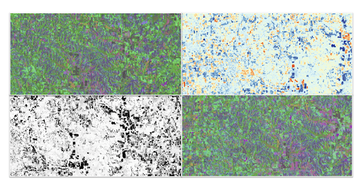
ALT Four satellite images show different embeddings.
11
26
130
10,376
Apr 13
There's a whole new way to work on Earth. 🌎 goo.gle/47ZSkqn
Combining iconic imagery with professional-grade data, no-code tools, and Gemini capabilities, Google Earth empowers professionals to validate reality remotely, de-risk projects early, and make better, faster decisions.
For decades users across the world have trusted Google Earth’s ground-breaking imagery of the real world. In today’s world, decisions are moving faster than traditional analysis can keep up. Google Earth is evolving to meet this challenge and save you time at work.
22
61
390
32,740