
🌪️ GROUND TRUTH
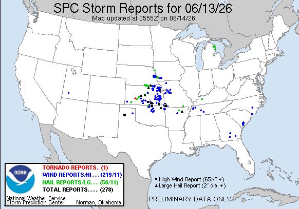
Saturday, June 13, 2026 delivered a SIGNIFICANT SEVERE WEATHER EVENT across the central U.S., anchored by DAMAGING WINDS as the dominant hazard.
STORM REPORTS (1200 UTC JUN 13 – 1159 UTC JUN 14):
• 🌪️ 1 TORNADO – landspout near Dodge City, KS (2245 UTC)
• 🧊 22 HAIL REPORTS – nearly all 1.00", one 2.50" report at Cord, AR (2035 UTC)
• 💨 WIND REPORTS SCATTERED BUT IMPLIED WIDESPREAD by warning/watch language describing 70-80 mph gusts
WARNING ACTIVITY (AGGREGATED BY OFFICE):
• ⚠️ 13 TORNADO WARNINGS (TOP 3, EAX 5, SGF 4, TSA 5, OUN 3) – focused KS/MO/OK
• ⚠️ ~177 SEVERE THUNDERSTORM WARNINGS – massive volume across Tier 1/2 offices (TOP 30, ICT 21, EAX 22, SGF 17, TSA 22, OUN 17, plus OAX 9, DMX 5, DVN 2, PAH 2, others)
• 🕐 Peak warning hours ~20-04 UTC, with late evening intensification into overnight
EVENT CHARACTER:
✅ ENHANCED RISK VERIFIED – widespread severe, concentrated KS → MO → OK/AR corridor
✅ DAMAGING WIND WAS THE DOMINANT THREAT – multiple bowing MCSs, 70-80 mph gusts mentioned in watches/MDs
✅ LARGE HAIL OCCURRED EARLY – isolated 2.5" hail with initial supercells before upscale growth
✅ TORNADO THREAT WAS LOW-END – only 1 confirmed (landspout), though 13 warnings suggest mesoscale concern was real
✅ TIMING VERIFIED – afternoon initiation, evening/overnight MCS evolution as forecast
━━━━━━━━━━
🎯 BOTTOM LINE
THE JUNE 13, 2026 OUTBREAK WAS A HIGH-END ENHANCED RISK SUCCESS, WITH THE FORECAST NAILING THE SETUP, PRIMARY HAZARD, AND EVOLUTION.
🎯 BIGGEST HITS:
• DAMAGING WIND AS THE HEADLINE THREAT – SPC called it Days 2 and 1; watch language emphasized 70-80 mph gusts; widespread MCS complexes verified
• GEOGRAPHY – Enhanced Risk corridor (eastern KS → western IL) was spot-on; warning clusters tightly aligned TOP/EAX/SGF/TSA offices
• EVOLUTION – initial supercells → upscale growth → bowing MCSs played out as advertised
• TIMING – afternoon initiation, evening/overnight intensification all verified
❌ NOTABLE MISSES:
• TORNADO THREAT UNDERPERFORMED – only 1 landspout despite 13 warnings and Tornado Watch 327/330 highlighting "a few tornadoes"; low-level shear/LCL issues limited tornadogenesis
• HAIL WAS SPARSE – 22 reports (mostly 1.00") vs. forecast for "large to very large hail"; upscale growth happened faster than expected, curtailing discrete supercell phase
🔑 KEY TAKEAWAYS:
1. SPC HANDLED COMPLEXITY WELL – morning MCV/outflow complications were acknowledged in Day 1; forecasters adapted confidently
2. WIND > EVERYTHING – when steep lapse rates rich moisture frontal forcing converge, upscale growth dominates; tornado/hail windows close fast
3. ENHANCED RISK WAS APPROPRIATE – warning volume, watch issuances, and wind reports all support that level; no evidence it should have been Moderate
4. MESOSCALE EXECUTION WAS STRONG – watches/MDs anticipated MCS evolution; real-time adjustments (WW 331, 332) captured evening intensification
5. EARLY DISCRETE PHASE WAS BRIEF – initial supercells (forecast for large hail/tornadoes) quickly merged; this limited high-end reports but didn't invalidate the forecast
OVERALL: A well-forecast, high-impact event that verified the Enhanced Risk with DAMAGING WINDS as the clear winner. The tornado threat was real in parameters but didn't materialize due to mesoscale details (LCLs, outflow timing). Strong operational performance across the board.
━━━━━━━━━━
🗺️ SPC VERIFICATION
DAY 2 OUTLOOK (ISSUED ~48 HRS PRIOR, 1257 AM CDT JUN 12):
• 🎯 ENHANCED RISK for eastern KS → west-central IL – VERIFIED geographically
• 💨 Emphasized DAMAGING WINDS as primary, with "isolated gusts to 70-80 mph" and "bowing MCSs" – VERIFIED STRONGLY
• 🧊 Highlighted LARGE TO VERY LARGE HAIL early with initial supercells – OCCURRED BUT SPARSE (22 reports, mostly 1.00", one 2.50")
• 🌪️ "Couple of tornadoes possible" – UNDERPERFORMED (only 1 landspout)
• 🕐 "Afternoon into evening/overnight" – VERIFIED
• ⚡ Key uncertainties flagged: morning MCV, outflow boundaries, northward extent of severe – all legitimate concerns that shaped Day 1
DAY 1 OUTLOOK (ISSUED ~24 HRS PRIOR, 0753 AM CDT JUN 13):
• 🎯 ENHANCED RISK refined to central Plains → lower Missouri Valley – MAINTAINED CONFIDENCE, VERIFIED
• 💨 "Damaging winds potentially evolving as the most prominent risk this evening, potentially including some significant (75 mph) wind gusts" – NAILED IT
• 🧊 "Large hail" with initial supercells – CORRECT BUT LIMITED BY FAST UPSCALE GROWTH
• 🌪️ "Potential for tornadoes...particularly late afternoon into evening" – OVERESTIMATED (13 warnings, 1 report)
• 🕐 Timing refined to "late afternoon into evening" initiation, "evening" for bowing segments – VERIFIED
• 📍 Geography tightened to central/eastern KS, western/northern MO as primary – SPOT-ON
DAY 2 → DAY 1 EVOLUTION:
✅ CONFIDENCE INCREASED APPROPRIATELY – Day 2 hedging on MCV/outflow gave way to Day 1's clearer focus on frontal forcing afternoon destabilization
✅ WIND EMPHASIS SHARPENED – Day 2 said "strong, damaging winds"; Day 1 said "most prominent risk" with 75 mph language
✅ TORNADO LANGUAGE WAS CONSISTENT – both days said "a couple" or "potential," neither oversold it
✅ GEOGRAPHY REFINED NORTHWARD – Day 1 pulled focus slightly north (away from Ozarks into MO Valley), which verified given TOP/EAX warning dominance
LOCAL NWS AFD INSIGHTS (TIER 1 – CORE OFFICES):
• TOP (13 PM update): wrestled with MCV/outflow timing, landed on 3-9 PM initiation near remnant boundaries → VERIFIED; emphasized upscale growth into MCS with damaging winds
• ICT (1 PM): flagged early outflow boundaries complicating evolution, noted efficient rainfall flooding risk SE KS → VERIFIED (heavy rain mentioned in reports)
• EAX (1 PM): called out St. Joseph area as CI focus, noted supercells → linear transition, emphasized wind as main threat → VERIFIED PERFECTLY (WW 327 centered there)
• SGF (2 PM): low confidence on afternoon isolated storms, HIGH CONFIDENCE ON EVENING MCS with 70-80 mph gusts → EXACTLY RIGHT; SGF forecasters nailed the two-phase evolution
• LSX (2 PM): acknowledged messy environment from morning convection, expected weakening as storms moved into stable air east → VERIFIED (fewer warnings E of MO River)
TIER 2 INSIGHTS:
• OAX: morning severe threat verified (9 warnings 10-21Z), then dry slot as advertised
• TSA/OUN: evening/overnight MCS threat emphasized → both issued ~20 warnings each as storms surged SE
OVERALL SPC PERFORMANCE:
🎯 GEOGRAPHY: EXCELLENT – Enhanced corridor was the bullseye
🎯 PRIMARY HAZARD: EXCELLENT – wind call was clear and verified
🎯 TIMING: EXCELLENT – afternoon → evening → overnight played out on schedule
🎯 HAIL: GOOD – forecast but upscale growth limited it
🎯 TORNADOES: OVERESTIMATED MODESTLY – "a couple" became 1 landspout; mesoscale (high LCLs, fast upscale growth) limited it
━━━━━━━━━━
📡 REAL-TIME ISSUANCES
WATCHES (8 ISSUED, 3 TORNADO 5 SEVERE THUNDERSTORM):
• 🌪️ WW 327 (1929 UTC, tornado) – NE KS/NW MO, initial discrete supercells → VERIFIED with TOP/EAX warnings, though only landspout reported
• ⛈️ WW 328 (2038 UTC, severe thunderstorm) – SE NE/N KS, large hail/wind → cancelled 0123 UTC after early threats diminished
• ⛈️ WW 329 (2220 UTC, severe thunderstorm) – SW/central KS, hail/wind along cold front → VERIFIED with ICT warnings
• 🌪️ WW 330 (2305 UTC, tornado) – NE OK/NW AR, "strong tornado possible" along outflow → VERIFIED WARNINGS (TSA 5, OUN 3) but no confirmed tornadoes; emphasized hail to 2.5" which occurred (Cord, AR)
• ⛈️ WW 331 (0153 UTC, severe thunderstorm) – SE KS/SW MO, damaging winds 70-80 mph → VERIFIED as MCS surged SE
• ⛈️ WW 332 (0235 UTC, severe thunderstorm) – W AR/C-E OK, "widespread damaging winds...to 80 mph likely" → VERIFIED overnight (TSA/OUN heavy warning activity)
MESOSCALE DISCUSSIONS (16 TOTAL):
• 🔥 MD 1122 (1849 UTC) → WW 327 – identified outflow boundary in NE KS, flagged supercell potential with tornadoes/hail/wind
• 🔥 MD 1128 (2229 UTC) – noted early NE OK supercell, flagged evening LLJ intensification → led to WW 330
• 🔥 MD 1131 (0102 UTC) – highlighted 3 large supercells, noted Kay County OK cell anchored on boundary → presaged WW 332
• 🔥 MD 1133 (0239 UTC) – called for WW 332 as bowing MCS surged into NE OK with 50 kt gusts already reported
• 📊 Pattern: MDs accurately anticipated watch needs, identified mesoscale features (MCVs, outflow boundaries,
58


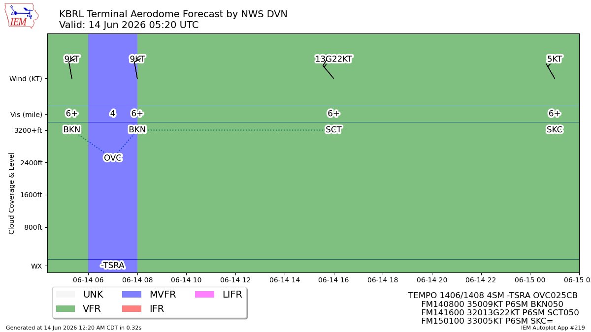
DVN issues Terminal Aerodrome Forecast (TAF) at Jun 14, 05:20 UTC for BRL mesonet.agron.iastate.edu/p.…
1

#DVN issues Area Forecast Discussion (AFD) at Jun 13, 10:50 PM CDT ...06z Aviation Update... mesonet.agron.iastate.edu/p.…
3

#DVN issues Area Forecast Discussion (AFD) at Jun 13, 10:50 PM CDT ...06z Aviation Update... mesonet.agron.iastate.edu/p.…
15
#DVN issues Area Forecast Discussion (AFD) at Jun 13, 10:50 PM CDT ...06z Aviation Update... mesonet.agron.iastate.edu/p.…
3


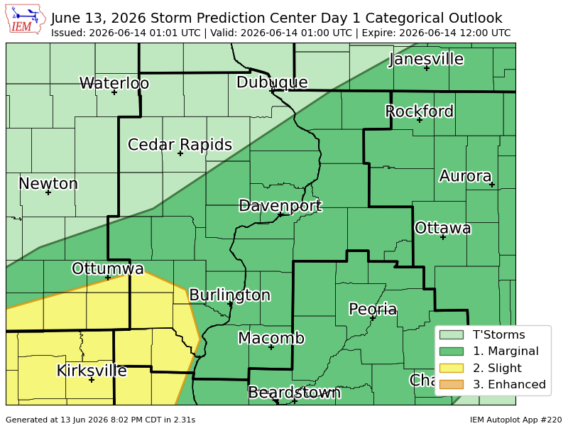
#SPC issues Day 1 Slight Convective Risk at Jun 14, 1:01z for DVN spc.noaa.gov/products/outloo…

2
760
#SPC issues Day 1 Slight Convective Risk at Jun 14, 1:01z for DVN spc.noaa.gov/products/outloo…
1
16
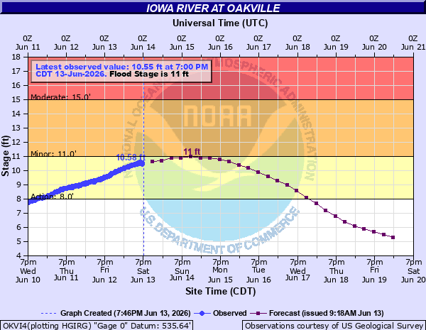
DVN issues Flood Warning valid at Jun 14, 1:00 PM CDT for Iowa River at Oakville [IA] till Jun 15, 9:00 AM CDT mesonet.agron.iastate.edu/vt…

4
DVN issues Flood Warning valid at Jun 14, 1:00 PM CDT for Iowa River at Oakville [IA] till Jun 15, 9:00 AM CDT mesonet.agron.iastate.edu/vt…
1
17
WPC issues Day 1 Marginal Risk Excessive Rainfall Outlook at Jun 14, 0:10z for DVN wpc.ncep.noaa.gov/qpf/excess…
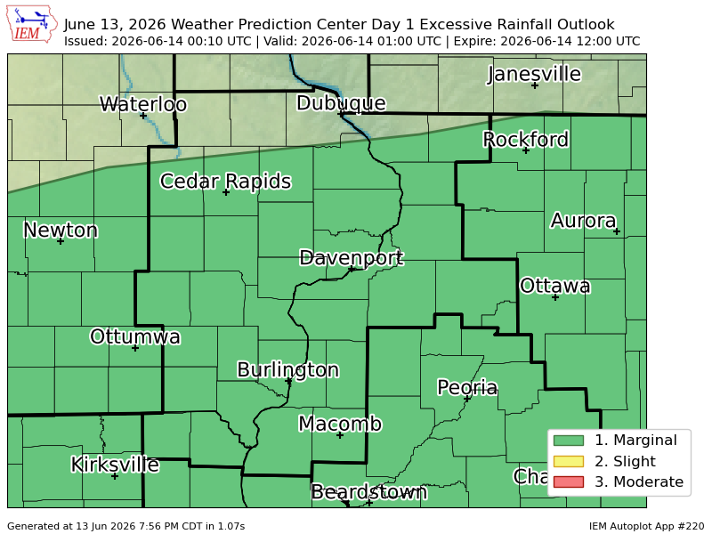
14
WPC issues Day 1 Marginal Risk Excessive Rainfall Outlook at Jun 14, 0:10z for DVN wpc.ncep.noaa.gov/qpf/excess…
