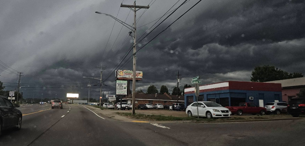
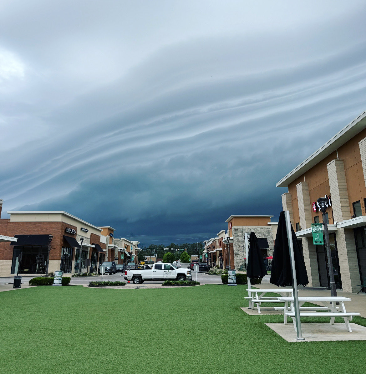
Hot and humid again today. Scatter thunderstorms this afternoon. A few of those storms could be severe producing damaging winds. #scwx #ncwx #clt #firstalert #storms
@WBTV_News
1
48
🚨 First Alert: HOT! With Storms Moving In This Afternoon 🚨
Few thunderstorms developing this afternoon. A few storms could pack damaging winds, especially after 3 p.m.
#FirstAlert #WeatherAlert #ncwx #scwx #clt #cltwx #OnYourSide #StormThreat #SevereWeather @WBTV_News


1
2
51
FLASH FLOOD WARNING: Flooding is occurring! Turn around. Don't drown! In the event of rising water, seek higher ground immediately. Open the #WSMV4 #FirstAlert Weather app now for the latest on our flood threat & storm timing. @WSMV #tnwx #kywx
232
4
503
4
467
Just hosted future meteorologist, Emma Ross, for a tour of #WSMV4! We talked weather, broadcasting, college and more. She’s going to do great!!
You never know — you might see her on the #FirstAlert Weather Team one day!
@wsmv

1
13
555
SEVERE T-STORM WARNING: 60mph wind gusts and/or 1" diameter hail possible in the highlighted area. Remain indoors/away from windows until this storm passes. Open the #WSMV4 #FirstAlert Weather app for the latest on our storm threat. @WSMV #tnwx #kywx
2
306
SEVERE T-STORM WARNING: 60mph wind gusts and/or 1" diameter hail possible in the highlighted area. Remain indoors/away from windows until this storm passes. Open the #WSMV4 #FirstAlert Weather app for the latest on our storm threat. @WSMV #tnwx #kywx
1
1
1
275
FLASH FLOOD WARNING: Flooding is occurring! Turn around. Don't drown! In the event of rising water, seek higher ground immediately. Open the #WSMV4 #FirstAlert Weather app now for the latest on our flood threat & storm timing. @WSMV #tnwx #kywx
1
1
202
SEVERE T-STORM WARNING: 60mph wind gusts and/or 1" diameter hail possible in the highlighted area. Remain indoors/away from windows until this storm passes. Open the #WSMV4 #FirstAlert Weather app for the latest on our storm threat. @WSMV #tnwx #kywx
174
SEVERE T-STORM WARNING: 60mph wind gusts and/or 1" diameter hail possible in the highlighted area. Remain indoors/away from windows until this storm passes. Open the #WSMV4 #FirstAlert Weather app for the latest on our storm threat. @WSMV #tnwx #kywx
1
1
4
406
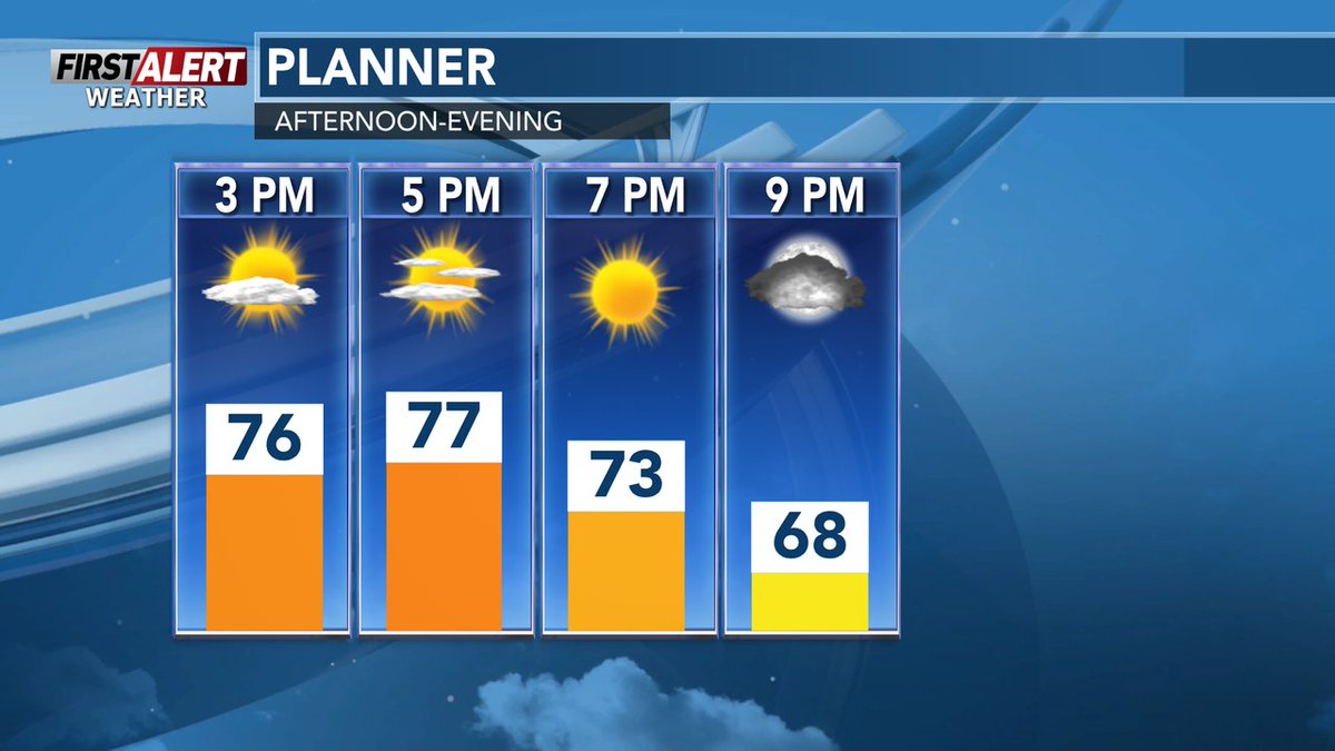
#WSAW #FirstAlert Weather- Here's a look at forecast for the rest of the day and evening.
Latest forecast can be found here-> wsaw.com/weather

27
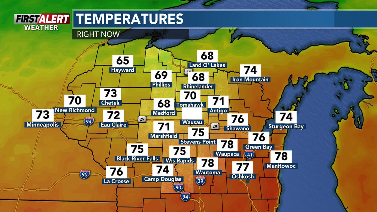
Here's a look at the lunch time temperatures across central #Wisconsin.
Latest #WSAW #FirstAlert #weather #forecast for the rest of the day-> wsaw.com/weather
2
41

Jun 13
First Alert: We're tracking a hot and humid Saturday across the Carolinas! 🌡️ Highs near 95° with heat index values around 100-105°. Scattered storms possible but most of us stay dry. Better chance for storms Sunday #FirstAlert #WeatherAlert #ncwx #scwx #clt #cltwx #OnYourSide


1
2
122

Jun 12
#WSAW #FirstAlert Weather- Here's a look at forecast for the rest of the day and evening.
Latest forecast can be found here-> wsaw.com/weather
28

A Flash Flood Warning has been issued for the following counties: Aroostook, Piscataquis until Jun 12 3:00PM.
Heavy rainfall has produced areas of flooding. Be sure to avoid any flooded roads and to not venture into flood waters.
#firstalert

116
Jun 12
Here's a look at the lunch time temperatures across central #Wisconsin.
Latest #WSAW #FirstAlert #weather #forecast for the rest of the day-> wsaw.com/weather

29

Jun 12
Made a routine Friday morning walk a little more special!…
#Brentwood…as the rain approached, by Adam Smith.
@alsmith031
@wsmv
#FirstAlert
4
231