
May 22
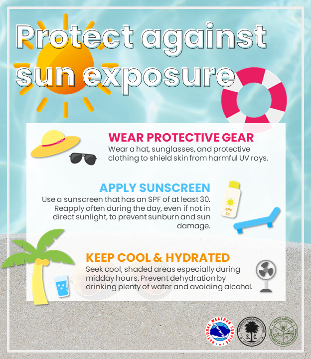
Today is the last day of this year's #HeatWeek, aka #DontFryDay.
Protect yourself and those you love by wearing protective gear, apply sunscreen, and keep hydrated every day–even when it’s cloudy. Regularly reapply every two hours or after you sweat or get wet! #HeatSafety
2
3
1,288

May 19
#HeatWeek continues! Remember to protect yourself during extreme heat and stay #WeatherReady. #HeatSafety weather.gov/heat
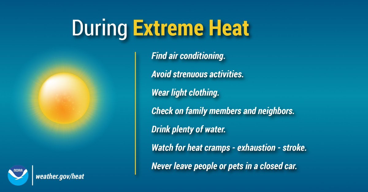
ALT Take precautions during extreme heat such as: find air conditioned areas, avoid strenuous activities, and drink plenty of water.
1
6
21
2,508
May 19
Today is day 2 of #HeatWeek. Remember to protect yourself during extreme heat and stay #WeatherReady.
#HeatSafety weather.gov/heat

3
7
525

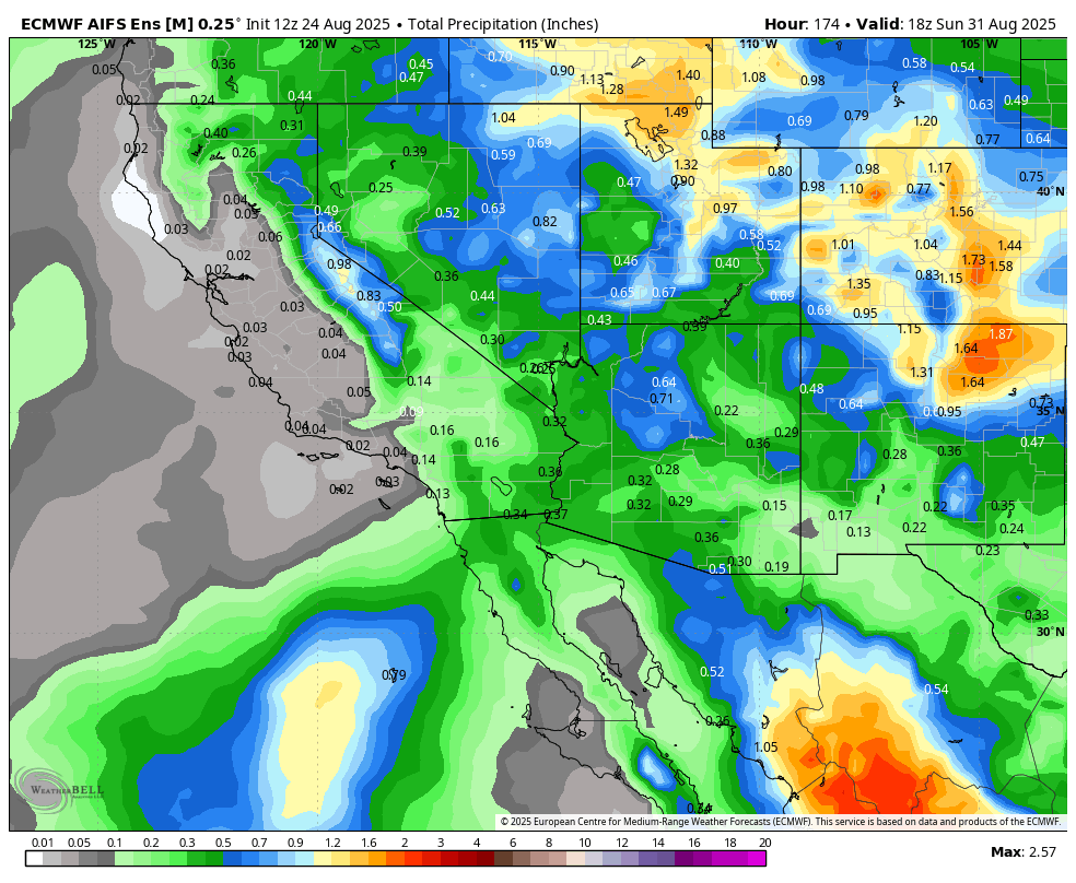
24 Aug 2025
Followers - Here is another AI data inputted forecast discussion, tailored for you. Enjoy!
1) Western U.S. Heatwave – Breaking?
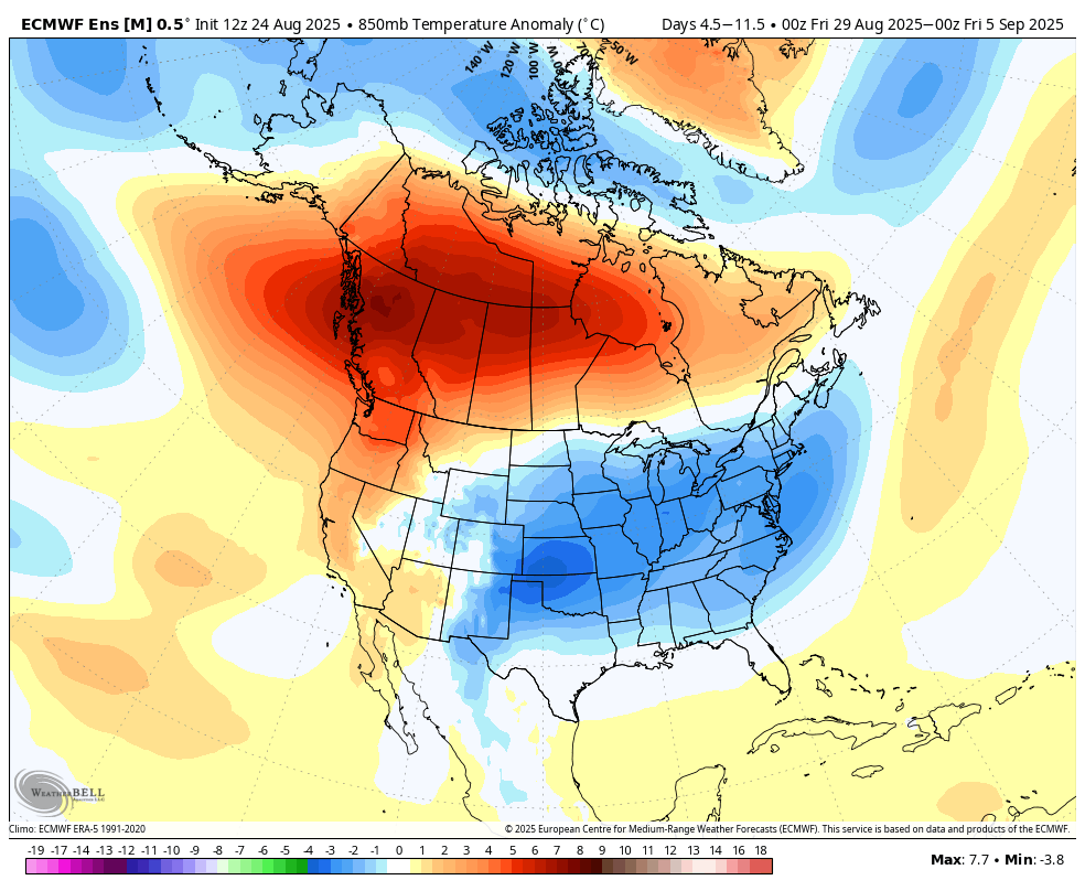
A major heatwave is currently affecting the western U.S., with record or near-record highs, especially in the Southwest and Southern California, and persistent warm overnight lows diminishing any nighttime relief. I have posted a current 850MB temp map from Euro AI.
This heat peaks thru today (Sunday) and begins to weaken thereafter, with gradual cooling into next week.
California and the Desert Southwest are at high wildfire risk during the peak heat period, due to fuel dryness and heat.
Timing: Expect relief starting late weekend into early next week, as the ridge that’s supporting the heat breaks or weakens, allowing cooler airmasses and/or monsoonal flow to push in.
In summary: The western heatwave is ongoing through the weekend, and we should start seeing cooler conditions early next week, though regional variability will exist.
2) Southwest and Monsoonal Flow
A monsoonal moisture surge is underway or imminent, pushing northward into the Southwest U.S., including Arizona, New Mexico, the Great Basin, and possibly portions of California and the Rockies.
This more consistent monsoon pattern appears more active than earlier in the season, with daily afternoon and evening thunderstorm chances, heavy localized rainfall, and flash flooding risks, especially in slot canyons, dry washes, and burn scars.
The monsoon surge is expected to linger through Labor Day, then gradually diminish but continue with scattered afternoon convection into early September.
Impacts include cooling in the Southwest and Central Rockies as moisture and cloud cover increase, mitigating some heat.
Bottom line: The Southwest is transitioning from heat-dominated conditions into a moist, thunderstorm-prone pattern with flash flood potential, particularly late afternoons/evenings through the coming week.
3) 8–14 Day Outlook (approx. Sept 1–7, 2025)
Based on the NOAA Climate Prediction Center 8–14 day outlook and hazards discussion: (cpc.ncep.noaa.gov)
Temperature:
Above-normal warmth is expected to continue across parts of the Pacific Northwest and Northern Intermountain West, though the extreme heat hazard is less likely to be present. Forecast highs may fall into more moderate ranges, not necessarily triple-digits.
In the Desert Southwest and California, extreme heat risk diminishes, and temperatures moderate compared to the peak heatweek.
Precipitation and Hazards:
Slight risk of heavy precipitation is possible in the Desert Southwest during the late portion of the 8–14 day window (around September 5–7), related to moisture surges and potential tropical cyclone influences.
Implications:
The heatwave out west subsides, but pockets of above-average warmth persist in the Pacific Northwest/Intermountain region.
Southwest transitions into a moist, westerly pattern, with increased rainfall potential and some heavy precipitation/flash flood risk around early September.
Fire weather risk may ease in many heated areas, though lightning and residual dryness might still drive localized hazards, particularly before the monsoon moisture fully establishes.
Summary and Outlook
Region Short-Term (Next Week) 8–14 Day Outlook (Early Sept) West (PNW, CA) Peak heat over weekend, then cooling begins Above-normal warmth may linger but extreme heat risk declines Southwest Monsoonal moisture builds, afternoon storms, flash flood potential Heavy rainfall risk around Sep 5–7; more cloud cover, reduced heat Intermountain/Great Basin/Rockies Mixed—some thunderstorms, moisture pulsing Temperatures near or slightly above normal, storm chances persist Desert Southwest Heat moderates, replaced by moisture and storms Elevated heavy precipitation risk in early September
Forecast Highlights
The western heatwave is breaking gradually, with the most intense heat through the weekend, followed by cooling into early next week.
In the Southwest, monsoonal flow is on the rise, bringing widespread potential for thunderstorms, localized heavy rain, and flooding concerns, particularly in terrain-sensitive regions.
During the 8–14 day period (approx. Sept 1–7), heat risk diminishes, storm/flood potential increases, and above-average warmth may persist in northwestern interior zones.
Desert Southwest may see significant precipitation in early September due to moisture surges, including possible hurricane remnants or tropical system influences.
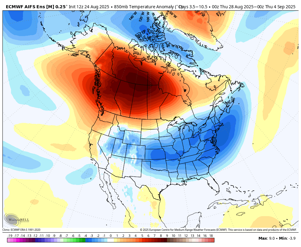
Below, I have added the Euro AI model for temp ranges throughout North America.....Canada is very warm, while the eastern 2/3 of the CONUS is below average in temps. West Coast moderates a bit. I have put the precipitation rainfall map thru the extended. Not much west of AZ, but the southwest east of CA gets so much needed precipitation.
Temps in the long range seem to warm up from east of the divide thru the east coast, so September seem to be warm all over the US. More on that later this week.........

4
3
47
2,331

17 Aug 2025
🔥 DAY 7️⃣🔥
You could win two tickets to see @SabrinaAnnLynn at Scotiabank Arena on Nov 11 🎟️
To Enter:
1️⃣ Text HEATWEEK to 68742
2️⃣ Reply with your email
*No purchase necessary. Entry Period 7 runs Aug 17 (10AM ET) - Aug 18 (10AM ET). Rules & privacy: bit.ly/4mqTL5P

6
13
2,367
16 Aug 2025
By texting "HEATWEEK", you are agreeing to receive electronic communications with info, offers, & promotions from Maple Leaf Sports & Entertainment Partnership (MLSE), 50 Bay Street, Suite 500, Toronto, ON M5J 2L2, mlse.com. You are free to unsubscribe at any time.
1
1,039
14 Aug 2025
🔥 DAY 4️⃣🔥
You could win two tickets to see @fluffyguy at Scotiabank Arena on Sept 19 🎟️
To Enter:
1️⃣ Text HEATWEEK to 68742
2️⃣ Reply with your email
*No purchase necessary. Entry Period 4 runs Aug 14 (10AM ET) - Aug 15 (10AM ET). Rules & privacy: bit.ly/4mqTL5P

1
2
1,354
13 Aug 2025
🔥 DAY 3️⃣ 🔥
You could win two tickets to see @tatemcrae at Scotiabank Arena on Aug 19 🎟️
To Enter:
1️⃣ Text HEATWEEK to 68742
2️⃣ Reply with your email
*No purchase necessary. Entry Period 3 runs Aug 13 (10AM ET) - Aug 14 (10AM ET). Rules & privacy: bit.ly/4mqTL5P

1
2
11
2,009
12 Aug 2025
By texting "HEATWEEK", you are agreeing to receive electronic communications with info, offers, & promotions from Maple Leaf Sports & Entertainment Partnership (MLSE), 50 Bay Street, Suite 500, Toronto, ON M5J 2L2, mlse.com. You are free to unsubscribe at any time.
7
3
1,235
12 Aug 2025
🔥 DAY 2️⃣🔥
You could win two tickets to #AEWAllOut at Scotiabank Arena on Sept 20 🎟️
To Enter:
1️⃣ Text HEATWEEK to 68742
2️⃣ Reply with your email
*No purchase necessary. Entry Period 2 runs Aug 12 (10AM ET) - Aug 13 (10AM ET). Rules & privacy: bit.ly/4mqTL5P

3
3
9
2,647
11 Aug 2025
Heat Week kicks off with your chance to win two tickets to @lorde at Scotiabank Arena on Sept 24 🎟️
To Enter:
1️⃣ Text HEATWEEK to 68742
2️⃣ Reply with your email
*No purchase necessary. Entry Period 1 Aug 11 (10AM ET) - Aug 12 (10AM ET). Rules & privacy: bit.ly/4mqTL5P

1
7
2,012

8 Aug 2025
2
8
278

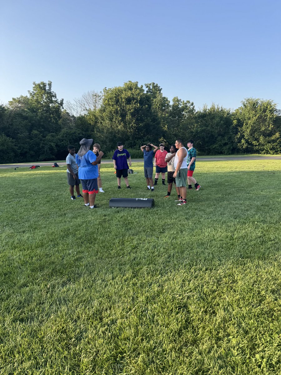
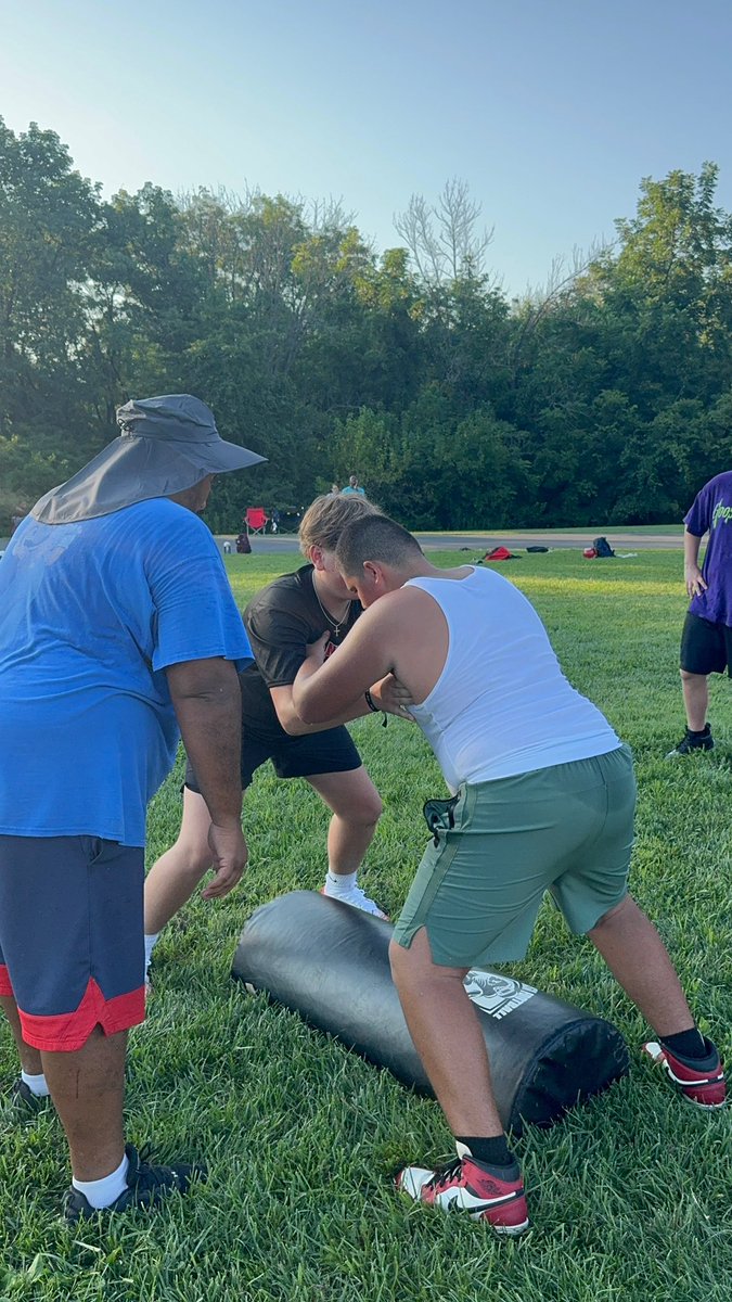
🏈🔥 Heat Week! 🔥🏈
Time to gear up and show out! 💪 #FootballSeason #StayReady #HeatWeek #YouthFootball #Hydrate 💦

4
180

18 Jul 2025
Heatwaves are a health and safety crisis.
Join us and heatstrike.uk to demand that the government implements a maximum working temperature.
Use our joint union heatwave protocol to help reduce the impact of heatwaves in your school. 👉 bit.ly/40jSLIf
#HeatWeek

3
1,012
15 Jul 2025
We support heatstrike.uk🔗
Communities across the UK are struggling in this heat. Schools and colleges need to prepare for these situations.
We need to protect workers by implementing a maximum working temperature now.
Read out joint union heatwave protocol here 👉 bit.ly/40jSLIf
#HeatWeek
9
15
2,056

14 Jul 2025
🔥 MELTDOWN MONDAY 🔥
It’s 2025. It’s too hot to work. And still — no legal max working temperature in the UK.
📣 Take action from home:
🖊️ Sign the petition: shorturl.at/FyZpG
📲 Share tag @heatstrike.uk
#TooHotToWork #HeatStrike #MeltdownMonday #HeatWeek

2
2
117

We should name every week of the year by their season! I'll start!
Late Winter Weeks (Weeks 1–8)
Frostweek
Snowweek
Chillweek
Iceweek
Blizzardweek
Crispweek
Auroraweek
Hailweek
Spring Weeks (Weeks 9–20)
Bloomweek
Thawweek
Rainweek
Budweek
Petalweek
Meadowweek
Fernweek
Springtideweek
Daffoweek
Blossomweek
Greenweek
Sunshineweek
Summer Weeks (Weeks 21–34)
Solsticeweek
Sandweek
Sunweek
Heatweek
Flameweek
Glowweek
Sparkweek
Emberweek
Horizonweek
Skyweek
Driftweek
Goldenweek
Harvestweek
Oasisweek
Fall Weeks (Weeks 35–46)
Rustweek
Mapleweek
Spiceweek
Amberweek
Sepiaweek
Equinoxweek
Acornweek
Ciderweek
Breezewweek
Pumpkinweek
Hearthweek
Lanternweek
Early Winter Weeks (Weeks 47–52)
Frostwoodweek
Mistleweek
Solsticeweek (Winter)
Snowglowweek
Northwindweek
Everweek
And don't forget Leapweek! (every 5 or 6 years)
(yes, this was GPT-generated)
1
4
50

17 Aug 2024
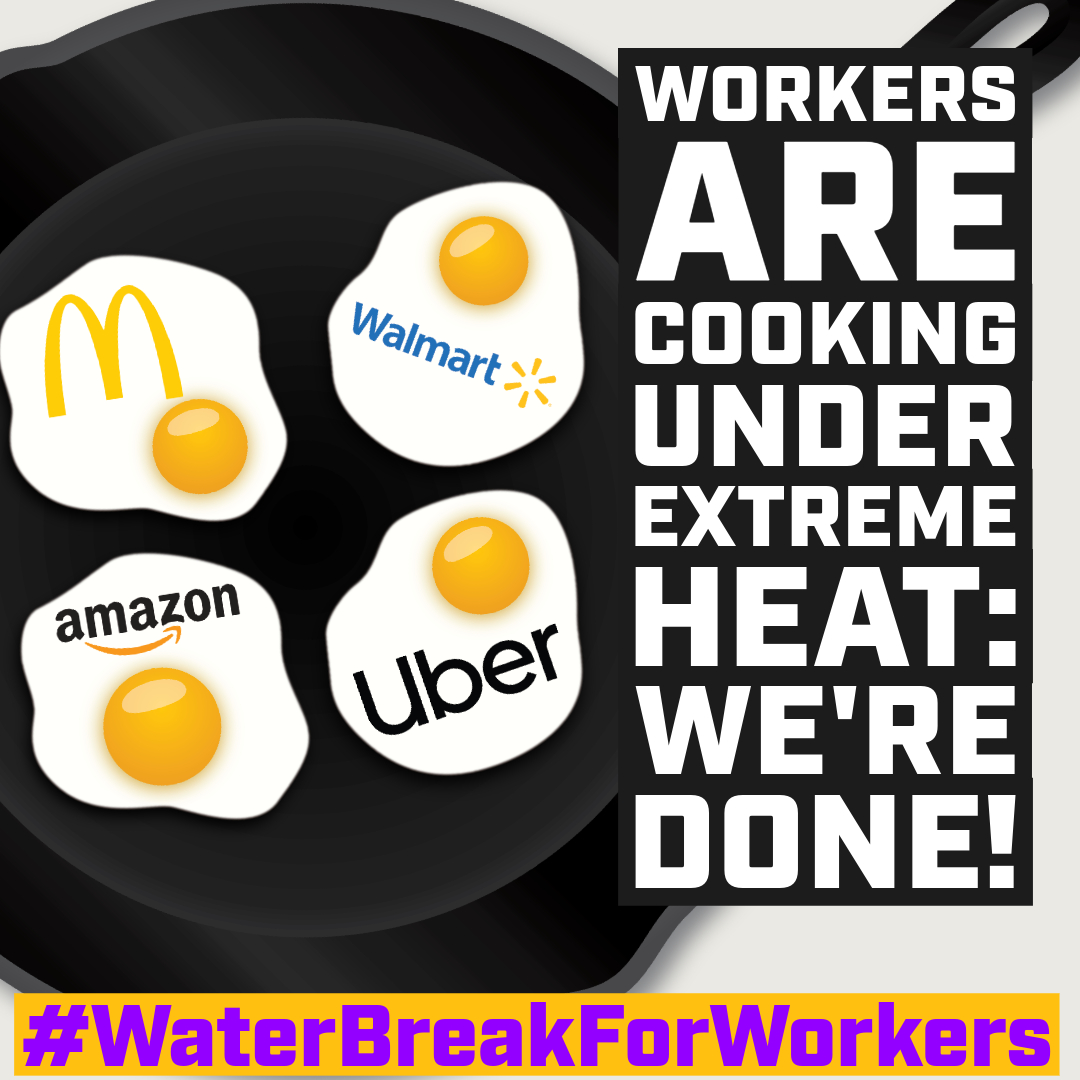
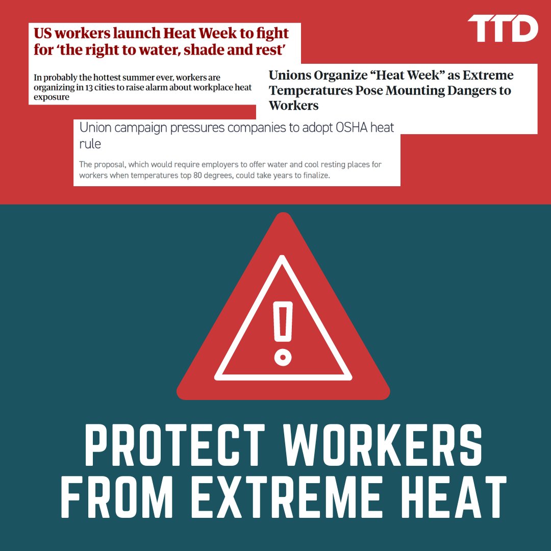
Worker injuries, illnesses, and deaths from extreme heat are rising every year. Urge the White House to enact OSHA heat protections NOW: nationalcosh.org/demand-heat…
#HeatJustice #HeatWeek #WaterBreaksForWorkers
1
3
138

16 Aug 2024
Being worked to death in the heat job is simply not something we will accept. But employers are failing to act, and in doing so, they are failing to protect workers’ lives and their health. #HeatWeek
truthout.org/articles/worker…
1
5
408

16 Aug 2024
Solidarity with everyone organizing for workers' rights to protections from extreme heat! #HeatWeek #HeatJustice
15 Aug 2024

HEAT WEEK 🔥: Labor unions and advocates are standing in solidarity to bring awareness to an issue that can be deadly: extreme heat. @SEIU, @UFWupdates, @GoodAiports, @RepCasar and more are demanding that employers adopt water, rest, and shade breaks. #HeatJustice
1
3
321