
🦀 Are You Still Relying Solely on LAL for #EndotoxinTesting?
Many QC teams working with #mRNA-LNPs, #biologics, #vaccines, and #complexformulations are finding that traditional approaches don't always fit today's development needs.
As the biopharmaceutical industry evolves, the demand for more sustainable, reliable, and high-performance endotoxin testing solutions continues to grow.
At Hzymes, we've developed a Recombinant Factor C (#rFC) Endotoxin Detection Kit designed for modern QC laboratories.
🔬 Why teams are making the switch:
✅ Animal-free and sustainable alternative to LAL
✅ High specificity with no G-factor pathway interference
✅ Suitable for samples with β-glucan interference
✅ Wide detection range: 0.005–5 EU/mL
✅ Excellent linearity (R² > 0.999)
✅ High repeatability (Intra-batch CV <10%)
✅ Compatible with commonly used microplate readers
✅ Proven performance in challenging matrices, including mRNA-LNP samples
Whether you're working on vaccines, biologics, #bloodproducts, #nucleicacidtherapeutics, #medicaldevices, or routine #QCtesting, endotoxin testing should never become the bottleneck.
💬 Comment "rFC" below or send us a direct message to receive the product brochure and validation data package. We'd be happy to discuss your sample types, validation requirements, and how rFC can fit into your endotoxin testing workflow.
hzymesbiotech.com/recombinan…
#EndotoxinTesting #rFC #QualityControl #Biopharma #Vaccines #mRNA #CellAndGeneTherapy #MedicalDevices #QC #CDMO
5

Field Service - Pippettes & Microplate Lab Equipment - Carrollton, TX #DiedreMoire #JobSearch #JobHunt #JobOpening #Hiring #Job #Jobs #Careers #Employment #jobposting #biotechjobs #FieldServiceJobs #LabTechnicianJobs bit.ly/3X5yTGW
9
Field Service - Pippettes & Microplate Lab Equipment - Ontario, CA #DiedreMoire #JobSearch #JobHunt #JobOpening #Hiring #Job #Jobs #Careers #Employment #jobposting #biotechjobs #FieldServiceJobs #LabTechnicianJobs bit.ly/3Kcxhbp
5


Jun 12
Machine learning uncovers 1,750 quakes tracing 250-kilometer edge of Alaska microplate lifeboat.com/blog/2026/06/ma…
1
31

We specialize in repair, servicing, calibration, and refurbishment #installation of analytical laboratory instruments such as #HPLC systems, gas #chromatographs #UV-Vis spectrophotometers, atomic absorption #spectrophotometer, flame photometer, microplate washer, gas generator.
38

Transform your lab efficiency. MicroBeta2™ & Twister™ III deliver automated microplate management with barcode scanning and continuous operation. Learn more: ms.spr.ly/6019QLyR5
#labefficiency #microplate
26

Jun 10
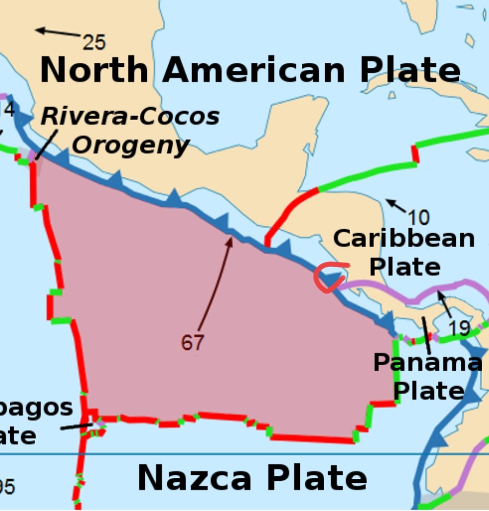
Misleading because the microplate aftershock is not related to PR trench EQ swarm and then the Nicaragua EQ is the Cocos plate intersection around Panama Plate of transform. Carribbean plate doesn't extend N either. Mw6.1 aftershock is a sole expected number.
Jun 10

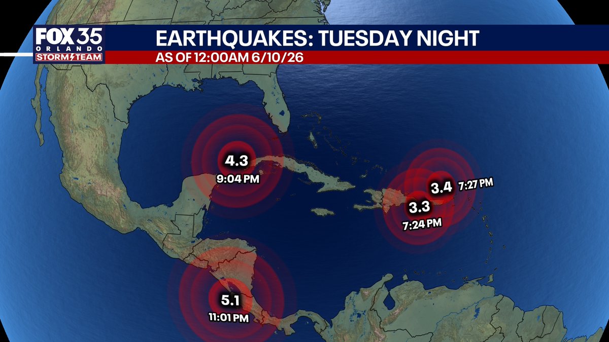
NEW: Aftershock! In nearly the exact place, we have had a 4.3 magnitude aftershock earthquake Tuesday evening in the Gulf. The Caribbean tectonic plate has become very active in Earth's crust with now 4 Earthquakes all within a few hour span of each other. The chances of another significant 6 magnitude one close to Florida are only about 2% in the next few days, but we will watch to see what happens.
4
519

Jun 9
ตอนทำแลปอยู่ก็มีคำถามงี้ แต่พอดูค่าที่ microplate reader คำนวนมาถึงได้เข้าใจว่านี่แหละมนุษย์ จั้นแบบ TT หนุรักอจ.นะคะ


1
60

Jun 8
Scientific analysis: 8 June 2026 southern Philippines M 7.8 earthquake
🟠Preliminary interpretation:
This was a major earthquake in the southern Mindanao–Sarangani region, close to the Cotabato Trench system.
NOAA/PTWC lists the event as M 7.8 Mwp, origin time 23:37:43 UTC on 7 June 2026 — 07:37 local Philippine time, 8 June — at 5.68°N, 125.204°E, depth 63 km.
Early agency solutions have differed, with some reports giving shallower depths, so the precise rupture plane and depth class should be treated as provisional until a centroid moment tensor, finite-fault model, and local relocation are available.
🟠Tectonic setting
The earthquake occurred in one of the most complex convergent margins on Earth. Southern Mindanao sits within the Philippine Mobile Belt, where deformation is partitioned among subduction, strike-slip faulting, arc volcanism, and microplate rotation.
The relevant structure here is the Cotabato Trench, west and southwest of Mindanao in the Celebes Sea.
Recent PHIVOLCS-linked analysis described the trench as lying west of southern Mindanao and noted that it has produced destructive historical earthquakes, including the 1918 M 8.3 and 1976 M 8.1 Moro Gulf earthquakes; the latter generated a devastating tsunami.
Mechanically, this is a compressional plate-boundary environment. Recent earthquake swarms along the Cotabato Trench have shown reverse-faulting mechanisms, consistent with subduction-interface or upper-plate splay-fault deformation.
🟠That is important here:
if today’s earthquake proves shallow, it may have ruptured the megathrust or an associated splay; if the deeper PTWC/US solution is closer to the final result, an in-slab or deeper interface event becomes more plausible. Both options are tectonically reasonable in this region.
🟠Source character and tsunami implications
A magnitude 7.8 event corresponds to a seismic moment of roughly 6 × 10²⁰ N m if treated as Mw 7.8.
That is large enough to rupture a fault patch tens to more than one hundred kilometres long, depending on stress drop, dip, and slip distribution.
The tsunami potential depends strongly on whether rupture produced significant vertical seafloor displacement.
A shallow thrust or splay-fault rupture beneath the sea is far more tsunamigenic than a deeper in-slab event.
🟠PTWC’s final message stated that the tsunami threat had largely passed and reported measured tsunami amplitudes at gauges including 0.33 m at Davao and 0.33 m at Talengen, Sulawesi, with minor sea-level fluctuations possibly continuing for several hours.
These gauge amplitudes do not necessarily represent maximum local run-up on exposed coasts, but they indicate that the observed basin-wide tsunami was much smaller than the initial worst-case warnings.
🟠Relation to recent Cotabato Trench activity
This event is scientifically significant because it follows months of heightened attention to the Cotabato Trench.
A January–February 2026 offshore swarm west of Kalamansig involved thousands of earthquakes, mostly small to moderate, and was interpreted as involving shallow upper-plate or splay-fault activity above the subduction interface.
The same analysis emphasized that swarms do not imply imminent great earthquakes, but they do show that the margin remains actively deforming.
🟠Today’s M 7.8 earthquake should therefore be examined in three ways: whether it ruptured the same segment illuminated by recent swarms; whether it transferred Coulomb stress to adjacent trench segments; and whether aftershocks define a dipping slab, a shallow splay, or a broader multi-fault rupture. Dense aftershock relocation and InSAR/GNSS deformation will be essential.
🟠Possible effects on nearby volcanoes
The key scientific point is this: a large earthquake can disturb volcanic systems, but it does not usually “switch on” a volcano unless that volcano is already close to eruption.
USGS summarises the condition clearly: earthquake-triggered eruptions require both sufficient eruptible magma and significant pressure in the magma storage system.
The literature also supports caution.
Manga and Brodsky’s review found that only a small fraction of eruptions are directly and immediately triggered by large earthquakes, because earthquake stress changes are generally small relative to the pressures needed to initiate eruption.
Dynamic seismic waves may perturb bubbles, permeability, hydrothermal systems, or chamber pressure, but a sustained magmatic response requires a primed system.
🟠Highest volcanic concern: Mélébingóy / Parker
Mélébingóy is the volcano to watch most closely, not necessarily because an eruption is likely, but because it has non-eruptive instability hazards.
It contains Lake Maughan in a steep-walled caldera and was the source of a major 1641 CE eruption.
GVP records that after a M 7.5 earthquake in 2002, PHIVOLCS staff dispelled eruption concerns, but reports described crater-wall failure into Lake Maughan and evacuation of families downstream.
GVP also records a destructive 1995 crater-lake overflow and flood that PHIVOLCS found was not volcanic activity.
For today’s earthquake, the plausible volcano-related hazards are therefore, in order of likelihood:
Crater-wall landslides, rockfalls, or lake seiches at Mélébingóy/Parker.
Hydrothermal disturbance, including changes in springs, fumaroles, lake chemistry, or diffuse gas output.
Short-lived volcano-tectonic seismicity beneath nearby edifices.
Eruption triggering, which is possible in principle but probably low probability unless independent unrest already existed.
🟠Matutum and Balut
Matutum is close enough to experience strong shaking.
Its pyroclastic-flow history makes it a serious volcanic system in long-term hazard terms, but earthquake shaking alone is not evidence of magmatic reactivation.
Monitoring should focus on new local earthquake swarms, deformation, fumarolic changes, thermal anomalies, and changes in groundwater or spring chemistry.
Balut is geographically closer to the epicentre, but GVP lists its last known eruption as Pleistocene and notes no weekly or bulletin reports in its database.
The main expected effects would be shaking-related slope instability or hydrothermal changes rather than eruption.
🟠Scientific conclusion
This earthquake is best interpreted as a major compressional event on or near the Cotabato Trench–southern Mindanao plate-boundary system, with the final classification dependent on refined hypocentre depth and focal mechanism.
Its regional importance lies not only in damaging ground motion and tsunami generation, but also in what it reveals about stress loading on a historically tsunamigenic margin.
For volcanoes, the scientifically defensible position is cautious but not alarmist: nearby volcanoes may be disturbed, especially hydrothermal systems and unstable crater-lake slopes, but an eruption would require a pre-existing near-critical magmatic system.
The volcano most deserving of immediate field and remote-sensing attention is Mélébingóy/Parker, because strong shaking can destabilise its crater-lake system even without magma ascent.
2
5
1,169

INTELIGÊNCIA ARTIFICIAL AJUDA A REVELAR UM ANTIGO SEGREDO GEOLÓGICO NO ALASCA!!!🌍🔬
Uma descoberta sísmica extraordinária está reescrevendo a geologia do Alasca! Prepare-se para uma viagem às profundezas da Terra, onde milhares de tremores revelam a anatomia oculta de um dos sistemas tectônicos mais complexos do planeta. 🔭✨ 🤯💫
Por décadas, essa placa foi um enigma geológico, mas agora, graças a um trabalho publicado na The Seismic Record, temos uma clareza sem precedentes. Este estudo não é apenas um artigo científico; é uma janela para entender as forças primordiais que moldam nosso mundo e causam terremotos. 💡⭐
Quer desvendar os mistérios da geodinâmica e ver como a ciência está mapeando o invisível? Não perca esta reportagem fascinante! Clique no link e mergulhe nesta aventura geológica. 🚀📚
POST NOVO NO BLOG!!!
Alasca: O Segredo da Placa Yakutat Revelado por Sismos Milenares - spacetoday.com.br/alasca-o-s…
#Alasca #Geologia #Sismos #PlacaTectonica #Yakutat #Ciencia #PesquisaCientifica #DescobertaCientifica #Terremotos #Geofisica #TectonicaDePlacas #EarthScience #GeologyRocks #SeismicRecord #AlaskanGeology #ScienceNews #Geodynamics #Microplate #Subduction #ExploracaoCientifica #ANUEarth #SouthDakotaMines #UCDavis


3
4
59
4,591

Jun 7
What is Natural Gas?
- Natural gas is a marine offshore hydrocarbon resource found within a viable, active petroleum system beneath the seabed of the Andaman microplate.
- It is a naturally occurring fossil fuel trapped in ancient geological layers—specifically the Eocene formation in this region—formed from the organic remains of marine microorganisms over millions of years.
- It exists under immense subterranean pressure, allowing it to flow naturally to the surface once the reservoir is punctured.
📍Location and Drilling Baseline
- The exploration is centered around highly specific marine coordinates off the Andaman coast, anchoring a multi-well exploration strategy:
- The Primary Well: Named Vijayapuram-3 (located at site OAEB).
- Geographical Position: Situated approximately 15 kilometers off the eastern coast of the Andaman Islands.
- Depth Profiles: * Water Depth: Drilled in 355 meters of marine water.
- Sub-Seabed Depth: The drill pierced down over 1,900 meters below the ocean floor into the Eocene geological strata.
- Historical Context: This site builds on Vijayapuram-2 (Location: OAEA), where natural gas was first struck on September 26, 2025. Together, these two successful wells out of three drilled confirm viable, commercial-grade reserves in the block.
1
12
890

Jun 4
2 #earthquakes strike the Juan de Fuca microplate system off the U.S. West Coast.
Routine tectonic activity—or the first hints of an ongoing undersea #volcanic eruption?
M 5.7 - 154km WSW of Pistol River, #Oregon
10km
2026-06-03 19:53:54
M 5.1 - 62 km W of Petrolia, CA
10km

3
52

May 22
remembered doing an assay with ascorbic acid as a control standard once and i have to pipette in… the dark 😂😂 in a microplate 😂😂 and prepare everything in the dark 😂😂 and my primary standard should also be prepared in the dark 😂😂
hopefully you are less stressed now? 🥹
1
1
8
735

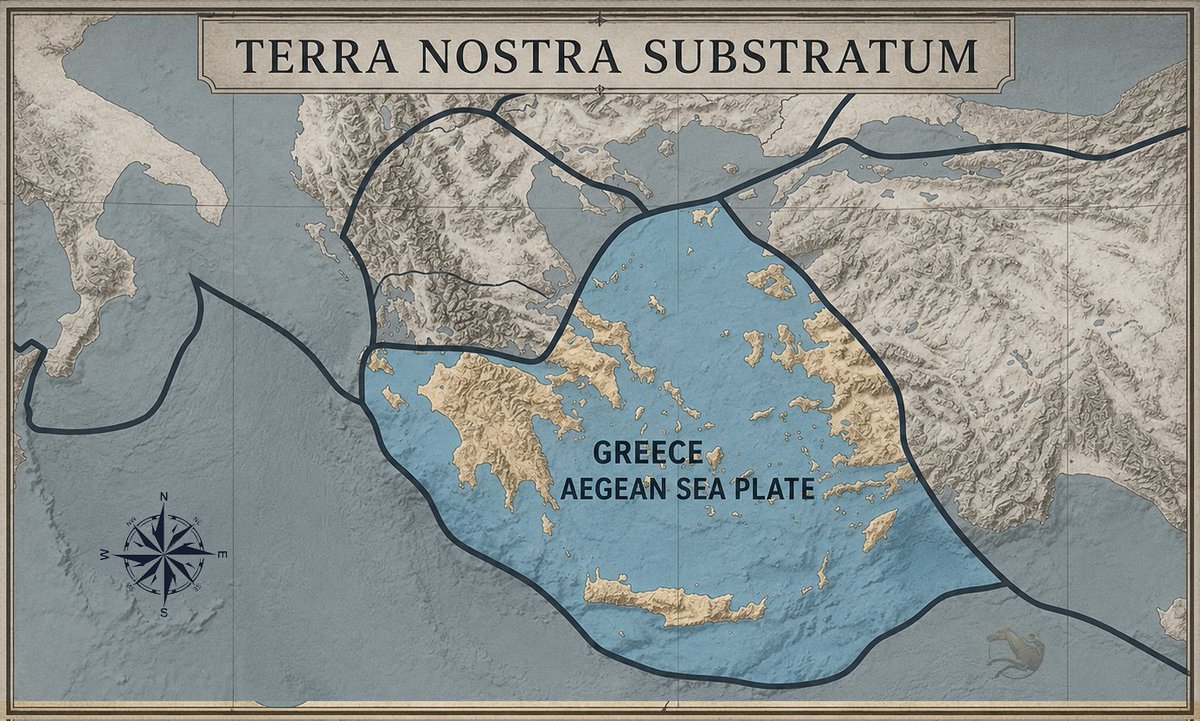
Based on Lithospheric Sovereignty, the Aegean Microplate is the solid basement upon which western Anatolia rests. Lacking an autonomous root and grounded upon the Terra Nostrum Substratum, the Asia Minor coast is an organic extension of the Hellenic domain.
32
44
194
20,655
May 16
🌋Suspected Central Bismarck Sea eruption, Papua New Guinea, May 2026
⭐️Regional volcanology and tectonic setting
The Central Bismarck Sea volcanic source is catalogued by the Global Volcanism Program as a submarine cluster/fissure vent at about 3.03°S, 147.78°E, with a listed summit elevation near −1,300 m.
Its historical record is extremely sparse: the only previously confirmed eruptive period in the database is the January 1972 submarine event, inferred from SOFAR/hydroacoustic and seismic signals resembling those produced by known submarine eruptions.
Tectonically, this is not an isolated oddity.
The site lies near the northern margin of the South Bismarck Plate, close to a junction between a transform-fault segment and an area of oblique active seafloor spreading.
Modern seismological work describes the Bismarck Sea Seismic Lineation as a roughly 1,000 km-long band of shallow earthquakes marking boundaries among the North Bismarck Plate, South Bismarck Plate, and Manus Microplate, with transform faults separated by spreading ridges and an extensional transform zone.
That is a highly plausible environment for submarine volcanism because extension, transform segmentation, and magma supply can coexist at plate-boundary stepovers and spreading segments.
The wider region is one of the world’s most active and hazardous volcanic provinces.
Papua New Guinea has many Holocene volcanoes, and RVO monitoring focuses on major active centres such as Ulawun, Langila, Manam, and Karkar.
The Central Bismarck Sea event is different from those better-known island volcanoes because it is offshore and submarine, meaning direct observation is difficult and early interpretation depends heavily on satellites, seismicity, hydroacoustics, and marine reports.
1
3
249

It keeps getting better!
- GENE-HACK-MAN & Hanta 🧬
July 2025
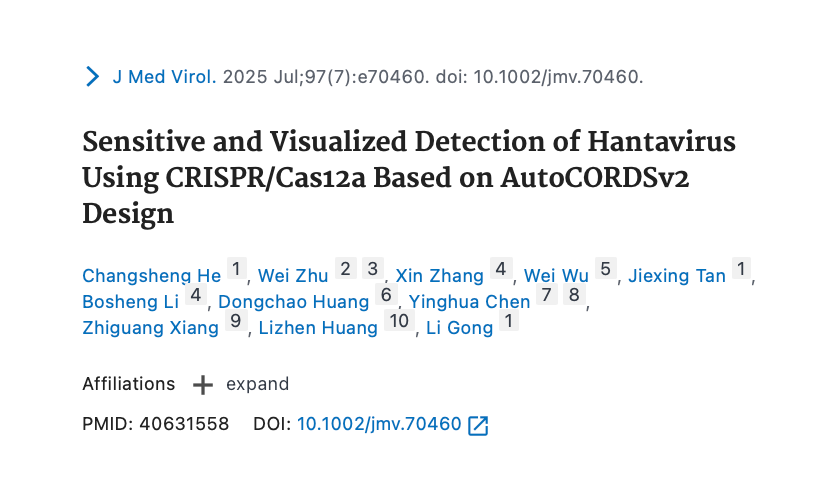
Sensitive and Visualized Detection of Hantavirus Using CRISPR/Cas12a Based on AutoCORDSv2 Design
Abstract:
In recent years, detection technologies based on the CRISPR/Cas12a method have been extensively utilized in the fields of nucleic acid, enzyme, and macromolecule detection, thereby reinforcing their significant role in the detection landscape.
Enhancing the simplicity of design, efficiency, and automation of the CRISPR/Cas12a detection system is essential for advancing its application in diagnostics. Recently, we developed an automated CRISPR/Cas12a design system named AutoCORDSv2.
This system can process published genomic sequences of pathogenic bacteria in a high-throughput manner and automatically generate conserved and highly specific crRNA sequences, along with primer sequences for target amplification.
This capability facilitates the specific and precise design of the CRISPR/Cas12a detection system. In this study, crRNAs targeting the Hantaan virus (HTNV) and Seoul virus (SEOV), as well as RT-PCR primers and RT-RPA primers, were designed using AutoCORDSv2.
The experimental results demonstrated that the CRISPR/Cas12a system, automatically designed by AutoCORDSv2, was specific for the detection of both the HTNV and SEOV, with no cross-reactivity observed with other pathogens.
The detection sensitivity reached 6 copies/μL (equivalent to 111 copies per amplification reaction), whether measured by a microplate reader or directly observed with the naked eye.
The detection results for 50 samples were consistent with those obtained from commercial RT-qPCR kits, indicating high precision.
Furthermore, the CRISPR/Cas12a system designed by AutoCORDSv2 can also be utilized for the development of a single-tube detection system with a sensitivity of 42 copies per reaction.
This system combined with a 5-min extraction step and RT-RPA, further underscoring its potential for application.
4
25
86
2,588

New Arrivals: Recommended
GK STREAK In Ear Earphones
New-Generation Upgraded Dynamic Driver Unit
Microplate Tweeter Unit
aliexpress.com/item/10050119…


3
7
521

Apr 28
We are manufacturer and suppliers of Clinical Lab Devices including Elisa Reader/ Microplate Reader, Microplate Washer, Biochemistry Analyzer, Blood Coagulation Analyzer, Auto ... narang.com/laboratory-produc…
#ClinicalLabDevices #LabDevices #ClinicalLabDevicesManufacturer
1
2
16

Apr 24
Basically this except the robot is holding a microplate with $5000 worth of antibodies
2
12
607