WA1147SWL retweeted

Jun 14
Radio is real-good taste. Stop scrolling, stop consuming. Tune in that shortwave radio and get real. Analog rules. WBCQ-always in good taste😆. Real people. Real issues. Real fun. Private to you through the magic of radio transmissions. Time to come back📻📻🇺🇸🇺🇸.
7
20
126
2,544

Just because a signal is received in Milan doesn't mean it was intended for Milan. These are shortwave signals, not phone calls. If you're unfamiliar with how radio signals propagate, you can find plenty of information online.
27

Many ham radio operators knew there would be a comeback of shortwave radio once again, to cut through the propaganda just like it did for 50 years, before social media essentially made the airwaves go quiet. The equipment is still out there. No monthly subscription.
1

In my day I spent hours listening to shortwave radio stations from around the world.
4
Gabriel Harber retweeted

🎙️ Forecast Brief
🎯 THE SETUP
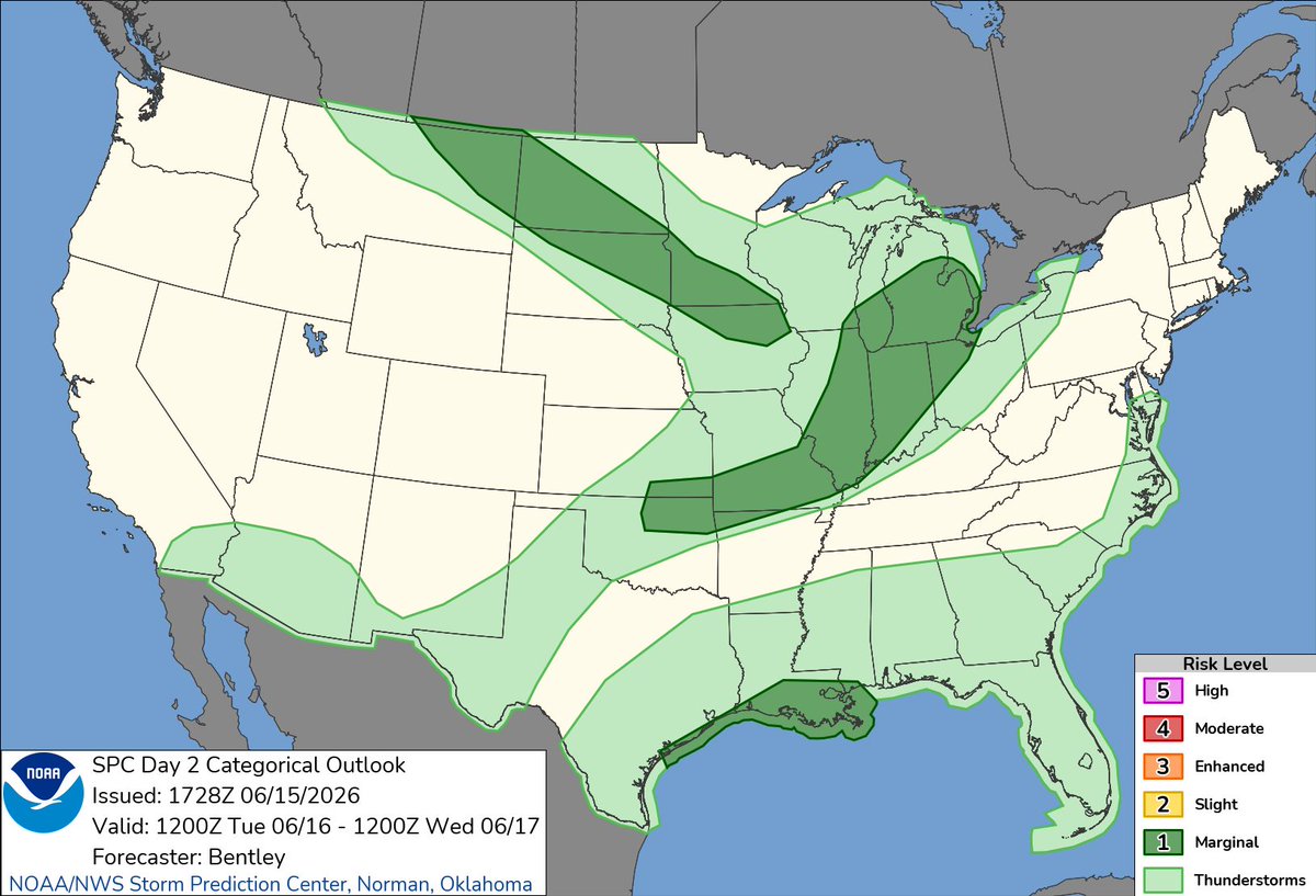
A compact mid-level shortwave trough will swing east through the Great Lakes on Tuesday, June 16, 2026, bringing scattered showers and thunderstorms to the Midwest. The early 0600Z outlook issued a marginal risk for the Midwest/Lower Michigan, but confidence in SEVERE POTENTIAL remained limited by lackluster boundary layer moisture—surface dewpoints only MID/UPPER 50S TO NEAR 60°F. The 1730Z update maintained the marginal risk across a broader swath from the northern Plains into the Upper Midwest and Great Lakes to the Central Plains, with the key message unchanged: STEEP LAPSE RATES AND STRONG SHEAR, but MOISTURE REMAINS THE LIMITING FACTOR. A weak cold front will push through the region during the afternoon/evening, serving as the primary focus for convective development.
━━━━━━━━━━
🗣️ KEY POINTS
⚡ MARGINAL (LEVEL 1/5) SEVERE RISK across portions of the Midwest into Lower Michigan Tuesday afternoon/evening—SCATTERED STRONG TO SEVERE STORMS possible
💨 MAIN THREAT: STRONG/DAMAGING WIND GUSTS AND ISOLATED LARGE HAIL; a few TORNADO SPIN-UPS cannot be ruled out given 100-200 m²/s² helicity values
🌡️ CRITICAL LIMITATION: MEAGER BOUNDARY LAYER MOISTURE—dewpoints only MID/UPPER 50S TO LOW 60S°F, capping overall severe potential
📍 CORE TARGET ZONE (TIER 1): NORTHERN INDIANA, SOUTHERN/LOWER MICHIGAN, NORTHWEST OHIO—best overlap of moisture, shear, and forcing along the afternoon cold front
🕐 PRIME TIMING: AFTERNOON INTO EARLY EVENING (ROUGHLY 18-00Z / 1-7 PM LOCAL) as the front moves through and diurnal heating peaks
🎯 CHASE POTENTIAL: LOW TO MODERATE—brief/transient supercells and clusters possible, but LIMITED MOISTURE AND INSTABILITY mean storms will struggle; NOT A HIGH-CONFIDENCE SETUP
⚠️ WEDNESDAY LOOMS MUCH LARGER—Enhanced (Level 3/5) risk developing for the same region with far better moisture, shear, and instability; SAVE YOUR ENERGY
━━━━━━━━━━
🌪️ CHASE POTENTIAL
🎯 CORE TARGET (TIER 1): NORTHERN INDIANA, SOUTHERN/LOWER MICHIGAN, NORTHWEST OHIO
- STORM MODE: Transient supercells and multicell clusters along and ahead of the weak cold front
- TIMING: 18-00Z (1-7 PM LOCAL), peaking mid-to-late afternoon as heating maximizes and front approaches
- ENVIRONMENT: Bulk shear ~35 KTS, lapse rates 7-8°C/KM, MLCAPE UP TO 1500 J/KG, SRH 100-200 M²/S²—sufficient for ROTATING UPDRAFTS and BRIEF ORGANIZED STRUCTURES
- THREATS: ISOLATED LARGE HAIL and STRONG/DAMAGING WIND GUSTS primary; BRIEF TORNADOES possible but not favored
- KEY UNCERTAINTY: MOISTURE RETURN—dewpoints starting UPPER 40S, rising only to MID/UPPER 50S by afternoon; CLOUD COVER from early convection may further limit instability
- CHASE VERDICT: LOW-TO-MODERATE CONFIDENCE—storms will be SCATTERED AND BRIEF, with the BEST ACTIVITY EAST OF I-39/I-65 where moisture slightly better; NOT A CHASE-FROM-HOME DAY unless already positioned
🌀 SECONDARY ZONE (TIER 2): NORTHERN IOWA/SOUTHERN WISCONSIN—OVERNIGHT
- STORM MODE: Elevated/isentropic convection along frontal zone late Tuesday night (near 12Z/7 AM Wednesday)
- ENVIRONMENT: Richer 850MB MOISTURE, 1500-2000 J/KG MUCAPE, strong shear beneath 100 KT 300MB JET, but ELEVATED INSTABILITY only
- THREATS: ISOLATED SEVERE WIND/HAIL possible; primarily a NOCTURNAL EVENT with low chase appeal
⚠️ BOTTOM LINE: Tuesday is a MARGINAL, MOISTURE-STARVED SETUP with BRIEF/TRANSIENT SEVERE POTENTIAL. The REAL SHOW IS WEDNESDAY—an Enhanced (Level 3/5) risk with far superior moisture, instability, and shear across much of the same region. CONSIDER TUESDAY A POSITIONING DAY and conserve resources for the more robust mid-week system.
━━━━━━━━━━
🧭 WHAT THE LOCAL OFFICES ARE SAYING
TIER 1 CORE (IWX/GRR/CLE/ILN): All four offices emphasize MARGINAL SEVERE RISK TUESDAY WITH DAMAGING WINDS/HAIL PRIMARY, but stress MOISTURE AS THE LIMITING FACTOR (dewpoints mid/upper 50s). IWX notes SHEAR/HELICITY SUFFICIENT FOR TORNADO SPIN-UPS; GRR highlights FIRST LINE LIKELY SUB-SEVERE, with BETTER SEVERE CHANCES EARLY EVENING as mid-level trough arrives; CLE/ILN both flag WEDNESDAY AS THE FAR LARGER CONCERN with Enhanced/Slight risks and all modes of severe weather possible.
TIER 2/3 OFFICES (LOT, IND, ILX, LSX, SGF, TOP, ICT, RNK, LWX, PBZ, AKQ, OAX, FSD, ABR, MPX, ARX) broadly echo the marginal threat at lower confidence, with most attention already shifted to Wednesday's more robust system; northern Plains offices (FSD/ABR/MPX) note Tuesday night elevated/isentropic activity along frontal zone, but severe potential remains conditional.
━━━━━━━━━━
👀 AREAS TO WATCH
🔍 NORTHERN OKLAHOMA: Conditional—some guidance hints at LATE AFTERNOON/EARLY EVENING STORMS in warm advection regime, but NO CLEAR INITIATION FOCUS beyond daytime heating; CONFIDENCE LOW. If storms develop, STRONG GUSTS AND ISOLATED HAIL possible; SPC may add low probabilities in later updates.
🔍 NORTHERN IOWA VICINITY—LATE NIGHT: ELEVATED CONVECTION with richer 850mb moisture and 1500-2000 J/KG MUCAPE possible near 12Z Wednesday; NOCTURNAL TIMING and elevated nature limit chase appeal, but bears monitoring if you're positioning overnight.
━━━━━━━━━━
✅ End of brief.
1
1
2
285

A couple questions that still have to be answered, and will likely only be answered on the day of...
1. The timing and distance of the two shortwaves within the broader upper trough.
Most guidance depicts a lead shortwave ahead of the main jet streak that'll host the morning convection, with the secondary shortwave within or near the jetmax, moving in by the late afternoon or early evening hours. This is the shortwave that'll drive the storms along the dryline, and potentially the open warm sector. Will there be subsidence in between these shortwaves, that may suppress convective development ahead of the dryline? If so, then the main event will take place along the dryline.
2. Timing and coverage of the early-day convection. The HRRR continues the narrative of the northward shift of the early convection and thus the effective warm front, but of course, this can still change considerably, because real-time observations will tell the true story (we saw very dramatic changes the morning-of the event last Thursday).
If the first round of storms moves out earlier, there will be more time for airmass recovery, and more instability along and near the warm front, and ahead of the dryline. Even if storms move out around 12-2pm, being that it's June, the window for recovery will be short, but may still be sufficient for at least moderate instability.
Again, these questions will likely only be answered on the day-of, but are some factors to consider when forecasting Wednesday's potential tornado outbreak. The ceiling is very high, but there are flies in the ointment that could suppress the higher-end tornado threat. Consider several factors and potential outcomes.
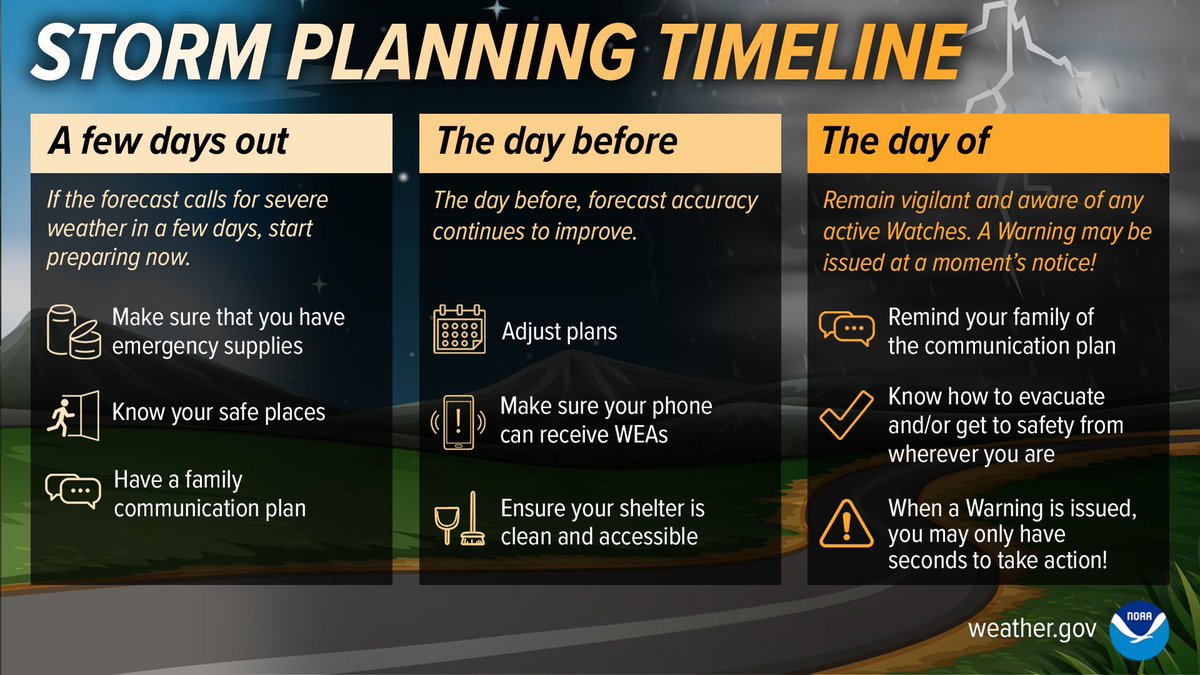
For those in the region preparing for this event, we're being technical in this thread, but the message is very straight forward: Please continue to monitor the forecast from the SPC, and stay close to good sources of information, and make sure you have your severe weather preparedness plan ready, if severe weather strikes!
We'll have more general-public facing information tomorrow, this is more of a nerdy/technical thread this evening.
2
3
10
1,270

Yes they transmitted responses but on a different protocol to the spectrum expected. It's like we're listening to shortwave expecting a stream of Morse but we find encrypted, distributed data bursts between naval ships. We can only infer ships are out there.
2
8

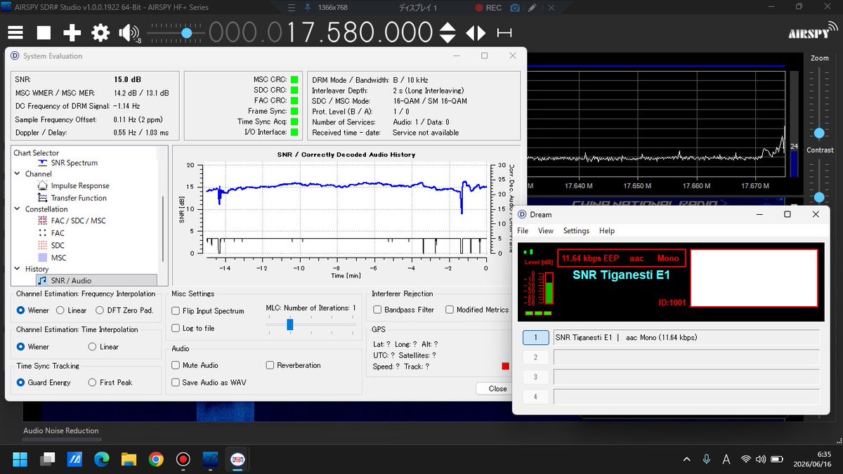
Radio Romania International 17580kHz DRM (aac Mono), Spanish
Target area: Argentina Brasil
Tx: SNR Tiganesti E1 🇷🇴(90kW Az247°)
Distance: 8,732km
21:22UTC (06:22JST)
Rx: Airspy HF Discovery 7m random wire
#drmlog #shortwave #短波放送
4
54

The super turbo blower #WOLFBOX #MEGAFLOW200 is perfect for cleaning the #TRX. This creates a small tornado. You can see what it looks like inside the #ANAN8000DLE. This is my flagship TRX for #shortwave. #hamradio

1
51

BBC World Service (Hong Kong relay): March 9, 1988 — The Shortwave Radio Audio Archive - shortwavearchive.com/archive…
22

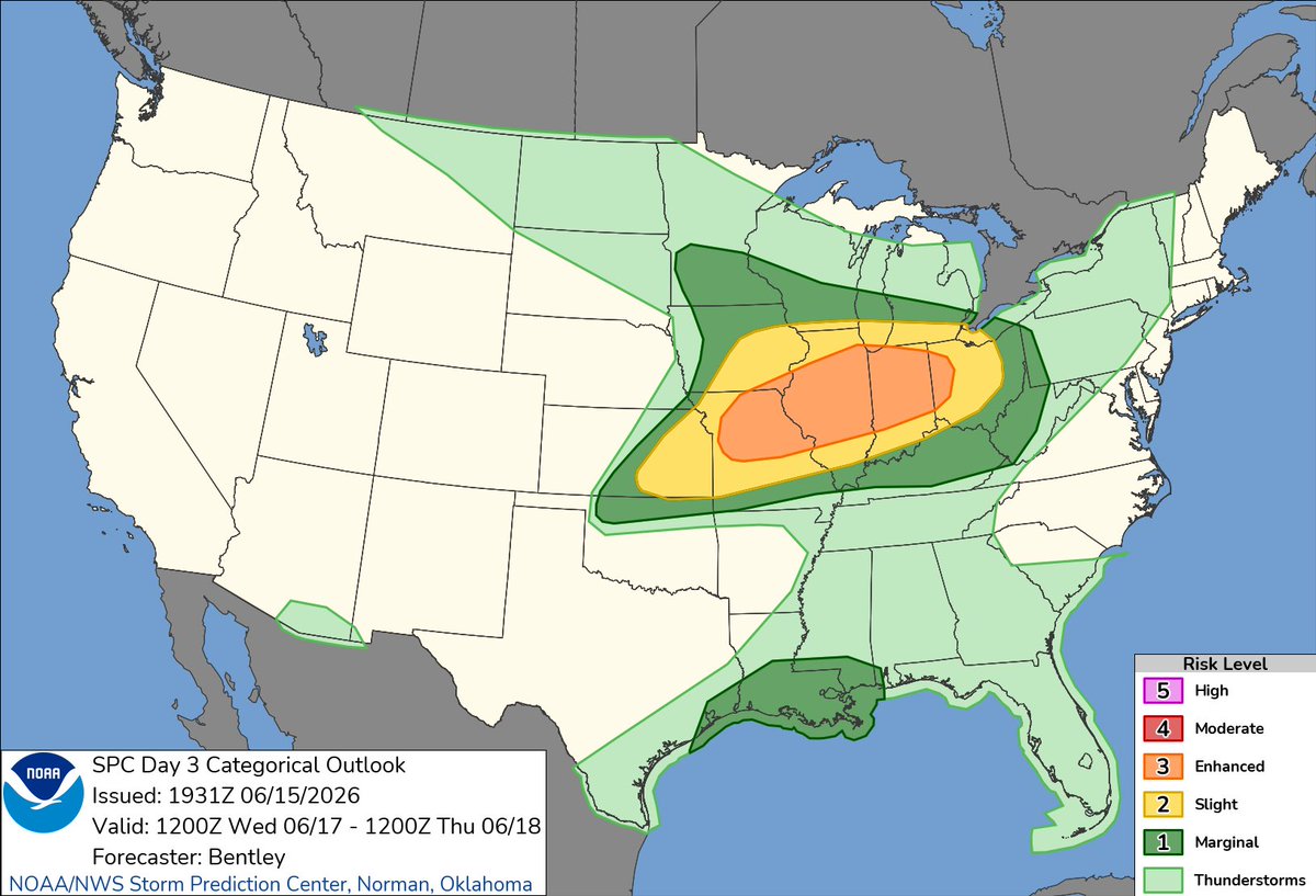
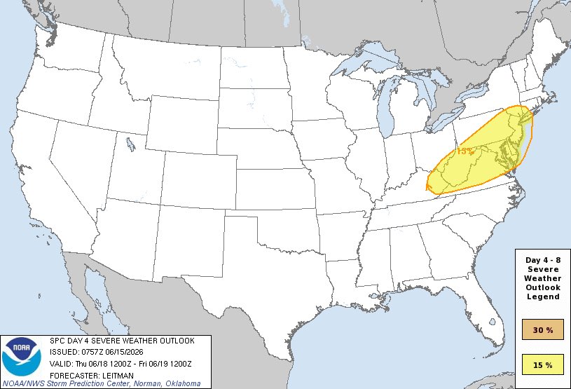
Midweek Severe Weather Outlook: Enhanced Risk Wednesday with Notable Uncertainty
The Storm Prediction Center’s latest Day 3–4 outlooks highlight an elevated severe thunderstorm threat midweek. Wednesday, June 17, carries an Enhanced Risk across portions of the Mid-Mississippi Valley into Indiana and western Ohio. Thursday, June 18, features a 15% probability of severe weather across parts of the Northeast and Mid-Atlantic.
Key Factors Driving the Setup
A moist, unstable air mass fuels strong updrafts, while wind shear from a strengthening low-level jet and robust upper-level flow promotes organized supercells and bowing segments. Lift from frontal boundaries, shortwave troughs, and mesoscale features, combined with steep lapse rates, supports the overall threat—particularly on Wednesday.
Timing
Wednesday: Afternoon through evening, with peak intensity late afternoon into evening.
Thursday: Primarily afternoon and evening as the system shifts east.
Expected Hazards
Damaging winds (60–75 mph in organized lines) are the main concern. Large hail is possible with supercells, and isolated tornadoes cannot be ruled out, especially Wednesday.
Tornado Outbreak Probability
The chance of a significant tornado outbreak is low—estimated at 10–15% in the Wednesday core area and lower on Thursday. Isolated tornadoes remain possible amid a mixed severe event.
Uncertainty, Limiting Factors, and Potential Outcomes
There is a moderate chance (40–50%) of the Wednesday Enhanced Risk upgrading to Moderate, with low odds (10–20%) of a rare High Risk. Limiting factors include weaker moisture/instability, reduced shear, frontal timing shifts, or “milky skies” (uniform overcast) that suppress initiation by limiting surface heating.
In a worst-case scenario, stronger moisture return and instability (CAPE >3000–4000 J/kg), optimal low-level jet and shear alignment, precise frontal lift, and minimal early convection could yield widespread supercells with very large hail (2–4 inches), multiple strong/intense tornadoes (EF2 ), and long swaths of damaging winds (75–100 mph), possibly evolving into bowing segments with widespread impacts. Thursday could strengthen similarly if parameters align.
Preparation Guidance
Prepare for the worst and hope for the best. Secure loose outdoor items, have multiple warning sources ready (weather radio, phone alerts), and designate a safe interior shelter location in advance. Monitor National Weather Service updates closely.
Share Your Observations
If you are in the affected areas and can do so safely, I would love to see your weather photos or videos of the storms. Feel free to send them my way for potential feature on the channel.
This setup shows how small atmospheric changes can significantly alter outcomes. Stay informed and stay safe.
#SevereWeatherAlert #MidwestSevereWeather #EnhancedRisk #TornadoThreat #DamagingWinds #StormPrep #StayWeatherAware #SevereWeatherOutlook
111

Imperial Japan hunted shortwave listeners in colonial Korea: 246 people investigated and 50 radios seized by Inspector Saiga Shichirō, a notorious torturer accused of fabricating cases and sending detainees to their deaths (1942–44) exposingimperialjapan.com/im…
6

More progressive shortwave though. Warm front interaction in IL will be key.
1
2
110

June 15, 2026:
The front and severe weather causing shortwave that has been moving East from the Midwest has finally cleared the East Coast and has provided a much needed respite from the humidity and instability. What is on tap for this week as far as dew points and severe weather are concerned??
East Coast & OH Valley - You will have dew points in the 40s and 50s today and Tuesday, but dew points will start to trend upward on Wednesday with severe weather chances going up for Ohio on Thursday.
Great Lakes down towards Missouri Valley - Enjoy today, as dew points start to climb again tomorrow, including a Marginal Risk for severe weather on Tuesday.
Mississippi Valley - Dew points start to climb again on Tuesday with severe weather chances heading up for Wednesday as a shortwave will make its way across to mix things up.
#weatheroutlook #severeweatheroutlook
39

A cool morning (39-52°) has led to a mild day with widespread 70s (8° warmer than yesterday). A pleasant evening ensues, but clouds do increase when the leading edge of a shortwave brings showers tonight. Then Tuesday & Wednesday showers, storms and gusty winds to 30 mph.

1
58

The dense globigerina limestone absorbs shortwave solar radiation during the day and slowly releases it as longwave thermal radiation at night, causing nighttime temperatures to stay up to 3°C warmer than the coastal perimeters.
1
1
8

11h
My father loved boxing. I sat with him many years ago and listened to the Rumble In The Jungle. We lived in Nigeria, and my father had the only shortwave radio that could pick up AFN out of Europe. Some three years later we were in Moscow, USSR, and I met Muhammad Ali.
1
185

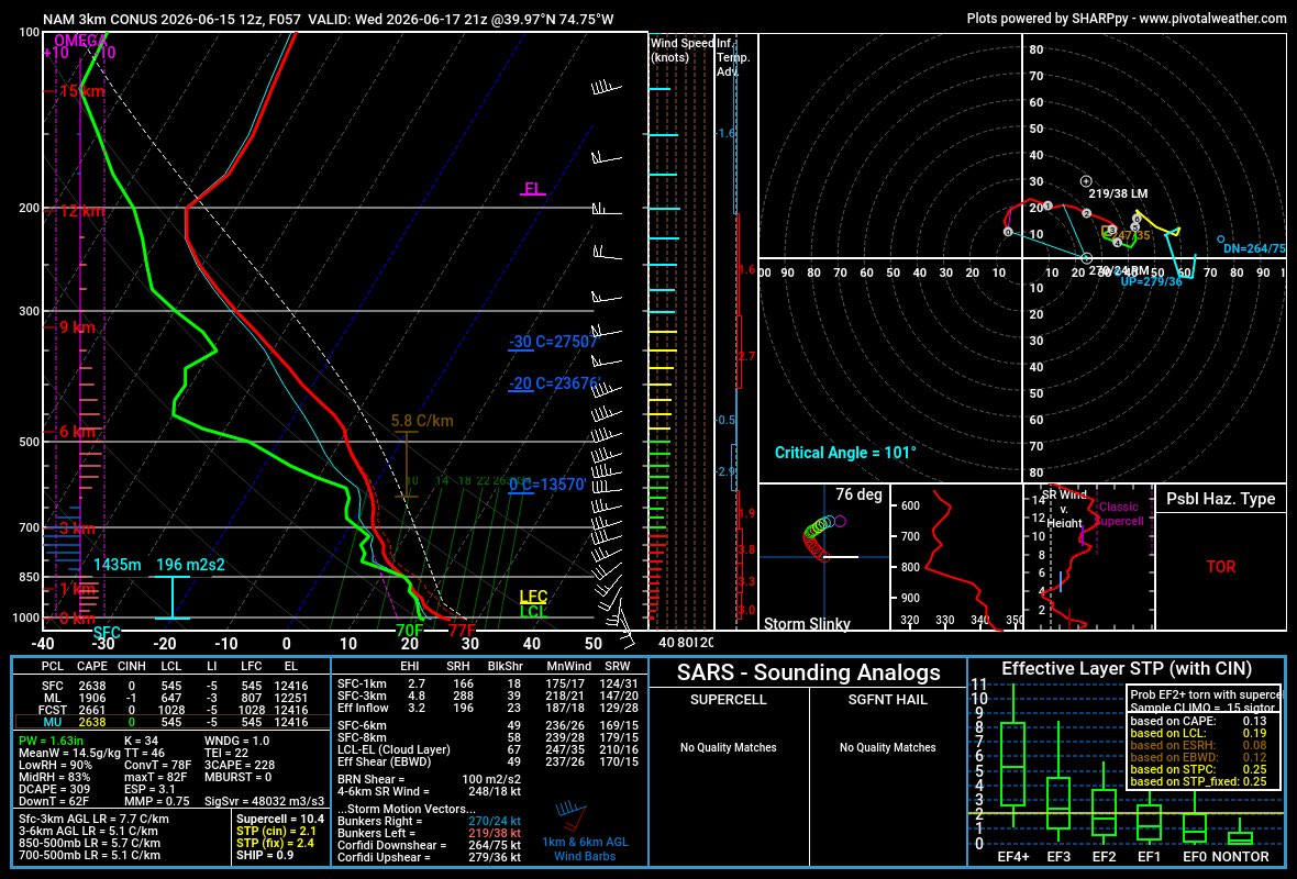
That's a good catch right there on the sounding. There is a window between 11am - 4pm on Wed before the shortwave lifts away from the area. This is the same thing which Michigan and northern Indiana will deal with tomorrow afternoon.

Wednesday is starting to have my attention across eastern PA through NJ and up through NYC. Wouldn't be surprised to see a marginal from the SPC when the new Day 3 outlook comes out this afternoon.
178