
📢 A digital twin approach for the identification and update of ecological infrastructure by Audrey Lambiel, Gregory Giuliani @greggiuliani, Nathan Külling& Anthony Lehmann
👉doi.org/10.1080/20964471.202…
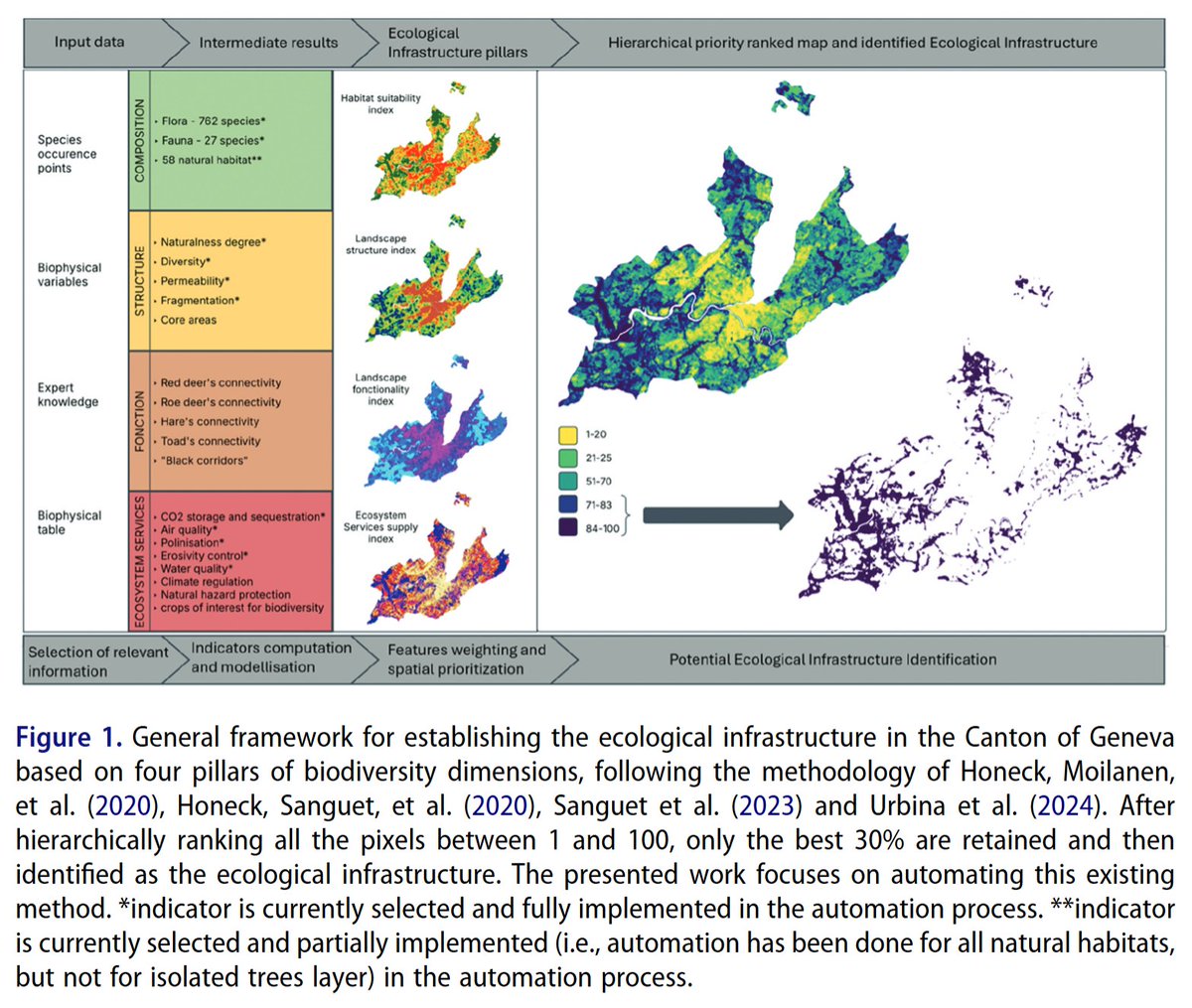
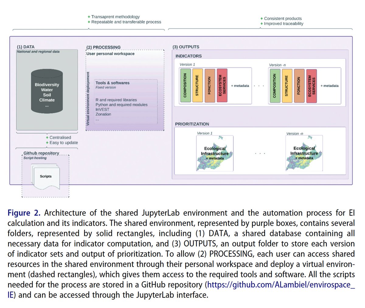
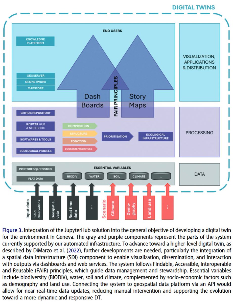
💌Addressing the global environmental crisis necessitates coordinated efforts, supported by open and #reproducibleresearch practices. Such practices aim to enhance the reliability, efficiency, and credibility of scientific outputs. Innovative tools are necessary for systematic conservation planning. This technical note presents a reproducible and automated approach for supporting #landmanagement and planning by identifying and updating ecological #infrastructure (EI). Grounded in #openscienceFindable, Accessible, Interoperable, and Reusable principles #datamanagement, and #digitaltwin (DT) concepts, the method focuses on the Canton of #Geneva, #Switzerland. It integrates species distribution modelling, #ecosystemservice assessments, and spatial prioritization within a shared #JupyterLabenvironment. The infrastructure centralizes data, automates indicator calculations, and ensures transparency, traceability, and reproducibility through version control and metadata generation. Ecological tools like #Zonationenable the identification of high-priority #conservation areas aligned with international targets. The system facilitates collaborative #workflowsand indicator updates. Its architecture allows scalability to broader regions and scenario modelling, laying the foundation for a DT of Geneva’s environment. Despite challenges in harmonizing workflows across institutional partners, this solution enhances efficiency and replicability in EI planning. The methodology is transferable to other regions and adaptable to various environmental modelling domains, offering a robust base for sustainable territorial management. All scripts needed for the process are stored and described in a #GitHubrepository: github.com/ALambiel/envirosp….
#Ecologicalinfrastructure #ecosystemservices #spatialanalysis #biodiversity #bigearthdata #digitalearth #geoscience #remotesensing #earthobservation #GIS #dataanalysis #BigData #FAIR #SpatialDataInfrastructure #SDI
3
454

May 5
Survey of India enables a deeper understanding of terrain through accurate representation of elevation using contours in topographical maps.
Contours provide valuable insights into landforms, slopes, and surface characteristics, helping users interpret whether the terrain is flat, undulating, or steep.
With consistent contour intervals and well-defined characteristics, these maps support engineering projects, route planning, watershed analysis, and infrastructure development across the nation.
@DrJitendraSingh @karandi65 @IndiaDST
#SurveyOfIndia #GeospatialIndia #ContourMapping #TopographicMapping #TerrainAnalysis
[GeospatialTechnology, SurveyingScience, ContourLines, DigitalCartography, SpatialDataInfrastructure, DroneMapping, GNSSSurvey, RemoteSensingData, InfrastructurePlanning, MappingIndia]
2
8
169
📢 Towards an AI Cube for EO data inference in a distributed infrastructure by Peng Yue & Kaixuan Wang
👉 doi.org/10.1080/20964471.202…
💌 Geospatial data cubes show great promise to facilitate integrated and efficient analysis of big Earth Observation (#EO) data. Existing #geospatial #datacube processing focuses more on traditional #geoprocessing algorithms. It is still unknown how to enhance cube analytics with geospatial artificial intelligence (#GeoAI) models. The paper presents an #AI cube approach to improve the cube capabilities from geospatial data storage and processing to the cube inference. The approach includes the proposal of a GeoAI model warehouse using a cube organization, a matchmaker for model selection, and a cube inference pipeline. It is developed using the on-the-fly and batch modes of model inference in a cube #infrastructure-based EO #cloud computing platform, the Open Geospatial Engine (#OGE). The implementation illustrates that the approach enhances traditional data cubes from physical models to GeoAI analysis and contributes to the development of an AI-ready #SpatialDataInfrastructure (#SDI). The on-demand model matchmaker and parallel inference improve the performance of GeoAI inference by achieving the best accuracy from available models and reducing the inference time by over 80%.
#bigearthdata #digitalearth #geoscience #remotesensing #earthobservation #GIS #dataanalysis #BigData #deeplearning #GIServices #Earthscience #informationsystem #WebGIS #SoftwareEngineering


1
4
1,592

8 Oct 2025
📘A Review of Pakistan’s National #SpatialDataInfrastructure Using Multiple Assessment Frameworks
By Munir Ahmad, Asmat Ali, Muhammad Nawaz, Farha Sattar and Hammad Hussain
👉See the paper: mdpi.com/2220-9964/13/9/328
2
4
105

9 May 2025
🚀 Kicking off #GEOINT2025 with open-source power!
Join me for the Introduction to #GeoServer worksho🛠️
📅 May 21, 7:30–8:30 AM
📍 America’s Center, St. Louis – Room TBA
Get hands-on with one of the pillars of open #geospatial tech!
🔗 usgif.org/geoint-symposium-t…
#FOSS4G #OpenSourceGIS #GeoNode #MapStore #OSGeo #GeoTech #SpatialDataInfrastructure #GeoSecurity #DefenseTech #GIS

1
3
295

27 Oct 2023
27 Oct 2023

Geospatial Data Standards refer to documents that outline the encoding, storage, exchange and utilization of data. These guidelines are maintained by organizations, like the International Organization for Standardization (ISO) & the Open Geospatial Consortium (OGC).
#geospatial

5
6
332

The workshop was coordinated by @ShailyGandhi and Mathias Jehling.
@rmadhan2000 @skvdst @IOER_de @isro
#SustainableUrbanDevelopment #IndoGermanCollaboration #SpatialDataInfrastructure #UrbanInnovation #IGSTC
1
2
258

24 Feb 2023
👩🏿🏫Interested in a list of websites that are either #SpatialDataInfrastructure platforms or SDI-related projects at national, regional or global levels?
ℹ️ Check out this page of the Global #SpatialData Infrastructure Association's website!
👉bit.ly/3gZRsXw
@AlvaroAnguix
ALT #InteroperableEU #Joinupreferral
1
3
267

5 Feb 2023
10 potential research topics in the field of spatial data infrastructure #spatialdatainfrastructure #spatial #Infrastructure #research #PhD
1
1
3
222
15 Sep 2022
🔎Searching for information about #SpatialDataInfrastructure development & implementations globally❓
📑Check out the list of websites that link to this topic, on the🌍Global #SpatialData Infrastructure Association's website❗
📙👉bit.ly/3gZRsXw
@AlvaroAnguix
ALT @KarenWyGis @amit_k_india @EuroGeographics @EUROGIonline @INSPIRE_EU @GISLounge @EuropeInGhana @InteroperableEU #InteroperableEU #Joinupreferral
1
3

29 Apr 2022
Meet our Rising Star, Jean Claude Ntirenganya
Jean Claude led the establishment of the #Rwanda #SpatialDataInfrastructure Hub, a platform for harmonized #spatial data collection and dissemination in the country.
Read Jean Claude's full profile at bit.ly/3KvDol8

12
13
40
16 Mar 2022
🌀Keen on a list of websites that link to #SpatialDataInfrastructure development & implementations globally❓
⚛️You can find it on the Global #SpatialData Infrastructure Association's website, check it out here❗
👉bit.ly/3gZRsXw
@AlvaroAnguix @j_michalkova @eddie_pickle

ALT @EUROGIonline @INSPIRE_EU @GISLounge @EuropeInGhana @InteroperableEU #InteroperableEU #Joinupreferral
1
3
10 Mar 2022
The World Bank continues cooperation with @het_Kadaster and @KU_Leuven to further develop St. Lucia’s #SpatialDataInfrastructure (SDI), making the country more resilient to #naturaldisasters @WorldBank

4
4
13 Aug 2021
🗺️Which are the websites that link to #SpatialDataInfrastructure development & implementations globally❓
🖥️The Global #SpatialData Infrastructure Association's website offers an extensive list of them, check it out here❗
👉bit.ly/3gZRsXw
@AlvaroAnguix @j_michalkova

ALT @amit_k_india @EuroGeographics @EUROGIonline @INSPIRE_EU @GISLounge #Joinupreferral
1
6

5 May 2021
Our #wigprofile feature this week is @BaovolaMada, an #InformationSystems Officer at National Geographic and Hydrographic Institute of Madagascar.
She contributes to the implementation of Madagascar's National #SpatialDataInfrastructure...
linkedin.com/feed/update/urn…

5
24

29 Jul 2020
4
6
9 Jul 2020
Talk about #thepowerofvisualization. @nsgic produced this #storymap to help the public consume and understand last year's Geospatial Maturity Assessment (GMA), the first ever state-level report cards for #gis. Check it out! #spatialdatainfrastructure nsgic.maps.arcgis.com/apps/M…
2
19 Jun 2020
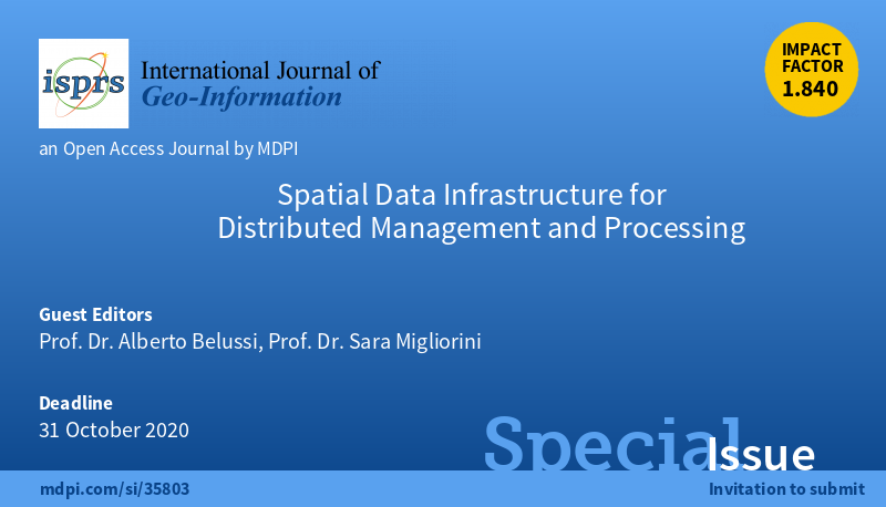
The Special Issue "#SpatialDataInfrastructure for #DistributedManagement and Processing" submission deadline has been extended. Edited by Prof. Dr. Alberto Belussi and Prof. Dr. Sara Migliorini.
The new deadline: 31 October 2020
Please see details: mdpi.com/journal/ijgi/specia…
1
3

17 Dec 2019
Our paper on building #OpenELS #LinkedData #SpatialDataInfrastructure on top of @INSPIRE_EU is accepted by #IJSDIR. It is not published yet, but you can read our #DataStory labs.kadaster.nl/stories/ope…
2
4
13

Interessanter Austausch mit der Namibia Statistics Agency @namstatsagency zu den Themen Aufbau von #Geodateninfrastruktur|en und internationale Kooperationen im Rahmen der Vereinten Nationen @UNGGIM.
#SpatialDataInfrastructure #Geodaten #GDI_DE @BKG_Bund

2
1