
Jun 15
The Southeast FireMap 2.0, developed in collaboration with @talltimbers1958, @TLA_Longleaf . Longleaf Alliance, @USEndowment, Ferguson Lynch, and @USDA_NRCS has been released.
Check out the map: landscapepartnership.org/net…

ALT A graphic banner featuring the text "SE FIREMAP" with "SE" in orange and "FIREMAP" in black. To the left is a logo consisting of a black and gray compass rose enclosing an orange and gray flame. The background shows a shaded map of the southeastern region of the United States, indicating areas including Texas, Florida, and the surrounding Gulf Coast states.
23

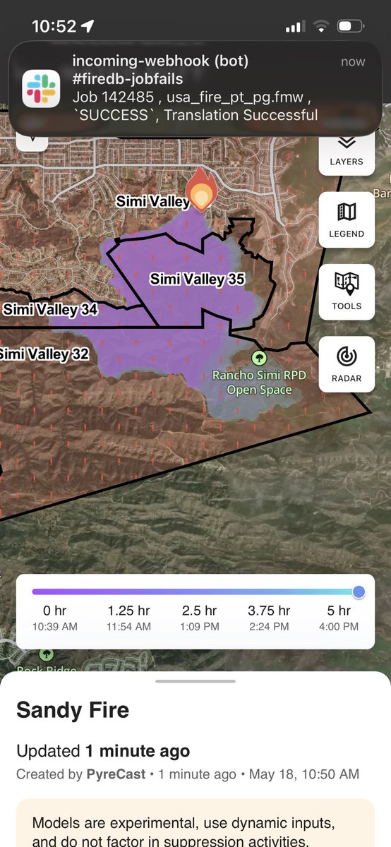
May 18
New perimeter data for the #SandyFire is on FireMap now. The 3D view shows the landscape behind the fire line.
7
33
8,603

May 18
Preview of the fire progression model available to pro users on the Watch Duty app plus 3D terrain from FireMap. Stay safe Ventura. #SandyFire

7
27
3,050
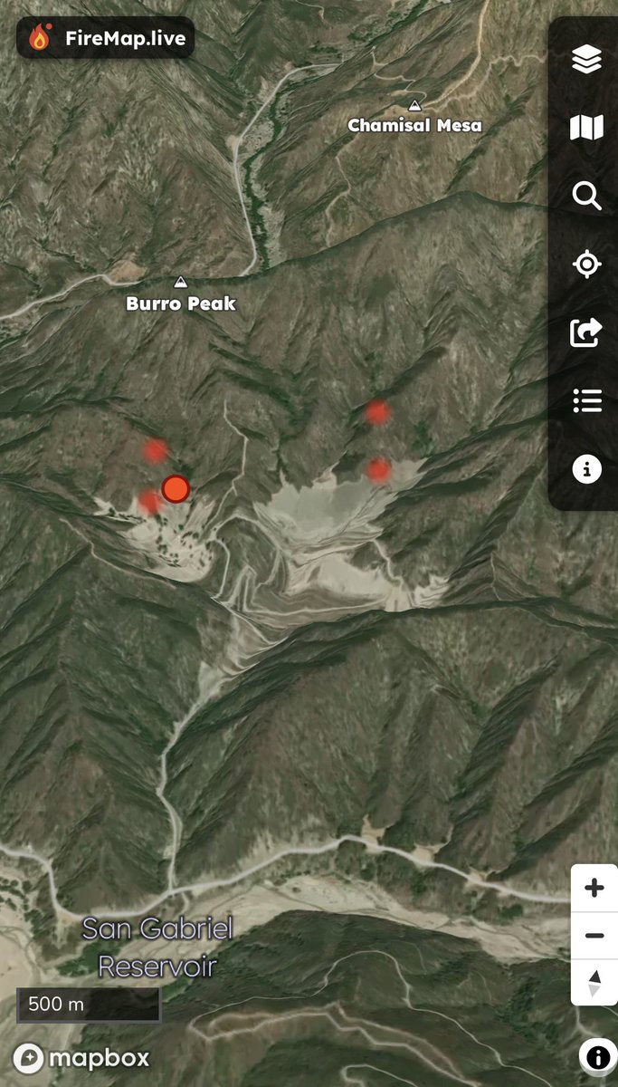
May 18
Preliminary hotspots and overview of the terrain from FireMap
2
129
May 18
🔥 Santa Rosa Island Fire Update
🗺️ Acres burned so far: 10,029🏝️ Total island size: 53,195 acres📊 18.85% of the island has burned
Live perimeter & spread tracking 👉 FireMap.live
#SantaRosaIsland #Wildfire #FireMap

6
24
2,425

Mar 9
Mysterious fires have become far too common and issue in Glasgow when it comes to landlords and real estate moguls. You should Google the Glasgow bell firemap.
2
2
153

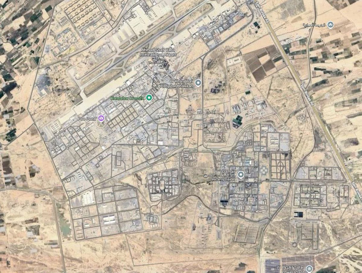
Major Hit 💥
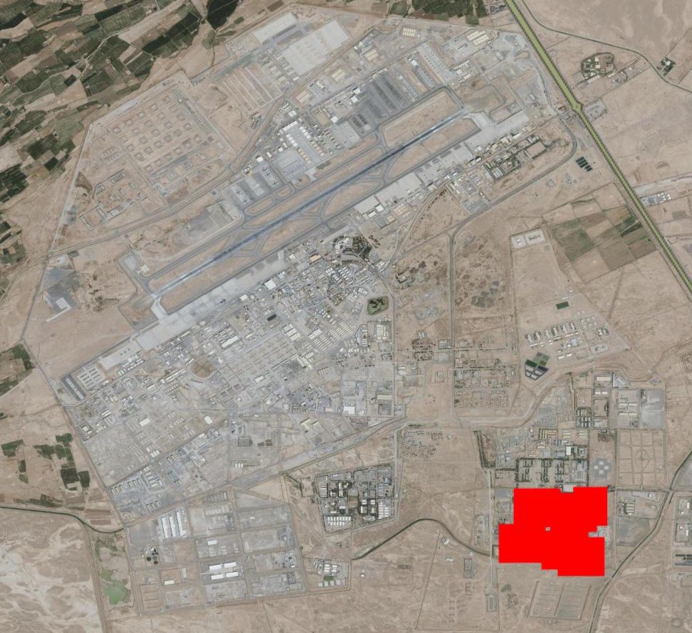
Now we can confirm Taliban controlled Kandahar Air field also precisely hit by the Pakistan Air Force.
Coordinates: 31°28'45.69"N 65°52'05.30"E
Confirmed from NASA Firemap, whole compound covered in fire & last night people were reporting huge blasts in Kandahar.
Source: @ForumStrategic

9
686

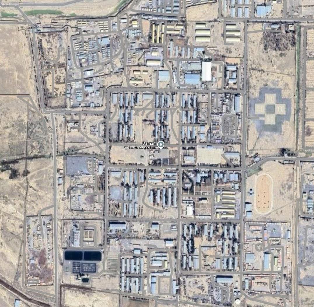
Feb 27
Major Hit 💥
Now we can confirm Taliban controlled Kandahar Air field also precisely hit by PAF
Coords: 31°28'45.69"N 65°52'05.30"E
Confirmed from Firemap, whole compound covered in fire and last night people were reporting huge blasts in Kandahar
#Operation_Ghazab_Lil_Haqq #AfghanistanPakistanWar
ALT NASA firemap results

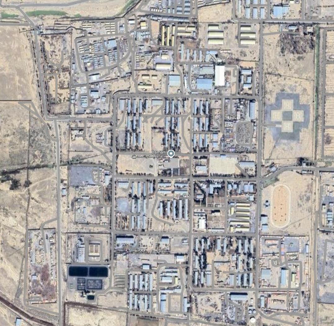
ALT The actual area covered in fire
1
46
236
18,317

Sandia research fuels innovation 🔥 Labs researchers developed FireMap, a software that identifies wildfire risks to help improve grid resilience. With support from @ENERGY I-Corps, the technology is now powering a new startup.
➡️ bit.ly/46BMdI3

ALT Screenshot of the FireMap software application, showing the user interface that visualizes wildfire risk.
7
702

👏🏼Los proyectos ‘De la tecnología a la acción social: FIREMAP como herramienta basada en IA para mitigar el impacto de los incendios forestales’, ‘Odontología responsable para frenar la resistencia antimicrobiana’ y la empresa Bodegas Vega Sicilia han sido reconocidos en el acto.

3
4
241

Jan 18
Satellites on Fire, Wildfire Map, Firemap o incluso Google Maps para visualizar focos en tiempo real.
3
347

20 Dec 2025
Hallo Anna. Ich erkläre Dir den Unterschied zwischen einem Profi u. Dir. Der Profi würde die These "Stadt in Trümmern" beweisen u. hierfür u.a. die Nasa-Firemap mal zeigen Webcams, Postings aus IG vorlegen. Aber ich verstehe mittlerweile, dass in /1
3
6
165

13 Dec 2025
FIREMAP y PHYRESEV-IA como nuevas herramientas aplicables en #IIFF, José Manuel Fernández Guisuraga @unileon en #TalleresCDF #INFOCAL #RedElectricaREE youtu.be/deGGdJPALXg?si=ZUVC…
6
9
1,476
13 Dec 2025
El proyecto #Firemap de @unileon, presentado en los #TalleresCDFsobre tecnología, pone al alcance de gestores forestales, administraciones públicas, servicios de emergencia y comunidades locales análisis satelitales sin necesidad de conocimientos técnicos previos
8
12
941

12 Dec 2025
12 Dec 2025

Public Alpha is coming.
We’re opening three maps for you:
🌿 Nature Map
Home of Nature, Water, and Electric AneeMates.

2
339

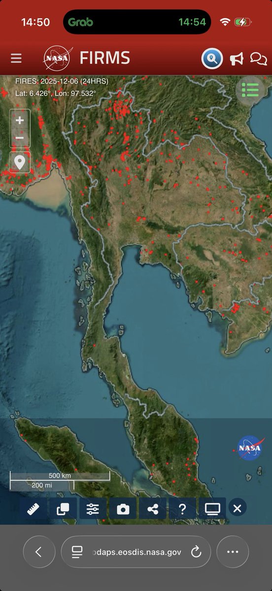
ถ้าดู Firemap รอบ 24 ชั่วโมงก็แทบไม่มีจุดเผา
รอนักสืบฝุ่นอนู่นะครับ
5 Dec 2025

ยังไม่ถึงฤดูกาลเผาเลย แล้วฝุ่น pm2.5 มาจากไหน เกษตรกรแม่งเป็นแพะรับบาปตลอด🙄🙄
11
8
2,435

17 Nov 2025
francopomba? firefeather? firemap? QUAL O NOME DO SHIPP


1
3
69


14 Oct 2025
🚒 DG #TelanganaFire Sri Vikram Singh Mann IPS attended a one-day workshop on N-FIREMAP,discussed on nationwide #Fire call data analytics, Asset & Invntry Mngmnt, HRMS, IT upgrades for #FireServices. #Telangana's tech leadership was proudly showcased—already ahead on most fronts.
1
4
275