
Real-time wildfire data at your fingertips 🌍 | Visualize global wildfire activity instantly 🔥
Joined May 2024
- Tweets 1,671
- Following 517
- Followers 4,953
- Likes 5,604
Photos and videos
FireMap.live 🔥🌎 retweeted

Jun 11
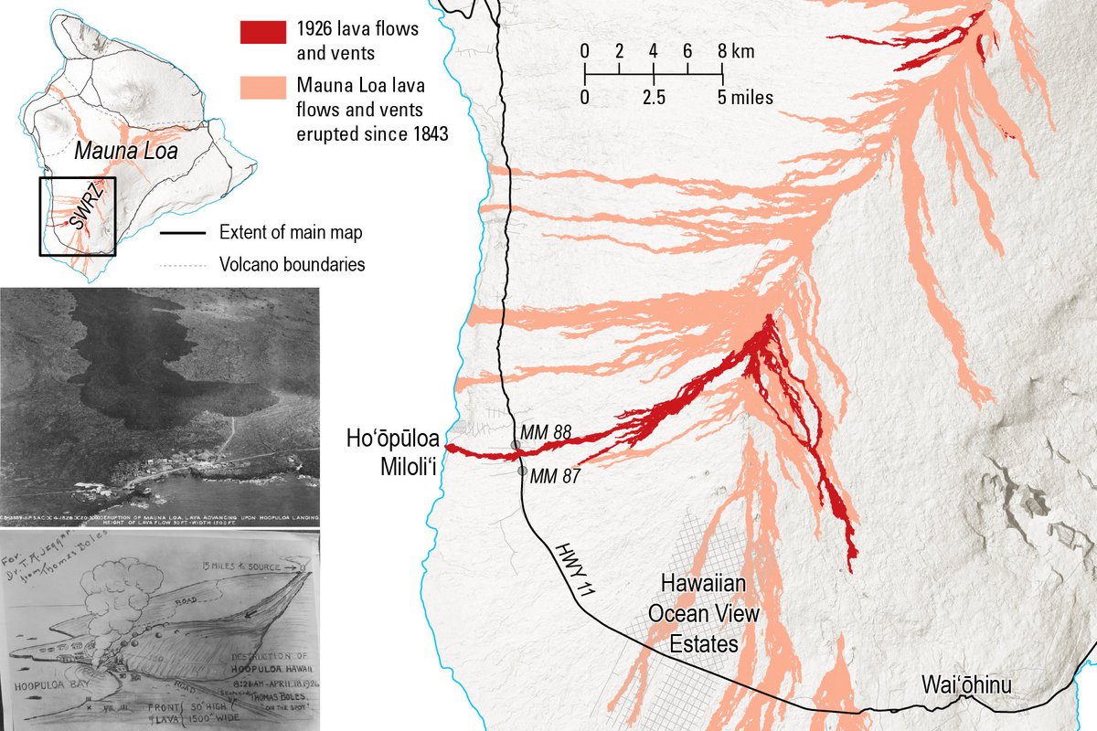
April marks 100 years since Mauna Loa’s 1926 Southwest Rift Zone eruption — an event that reshaped South Kona and destroyed Ho‘ōpūloa village. It also produced the first aerial photos of active Hawaiian lava flows.
Learn more: usgs.gov/observatories/hvo/n…
🗺️Map of the 1926 Mauna Loa lava flows (red), with all Mauna Loa lava flows since 1843 shown in peach. The photo on the left was taken on April 17 by the U.S. Army Air Corps,11th Photo Section, and shows that the flow advancing towards Ho‘ōpūloa village. The sketch on the bottom left is by Thomas Boles, the first superintendent of Hawaii National Park, drawn as lava was inundating Ho‘ōpūloa village.
#1926 #MaunaLoa #VolcanoWatch
25
117
6,069
FireMap.live 🔥🌎 retweeted

Jun 8
Severe damage in the Southern Philippines, following a 7.8 magnitude earthquake. Tsunami warnings have been issued.
65
707
2,244
408,935
FireMap.live 🔥🌎 retweeted

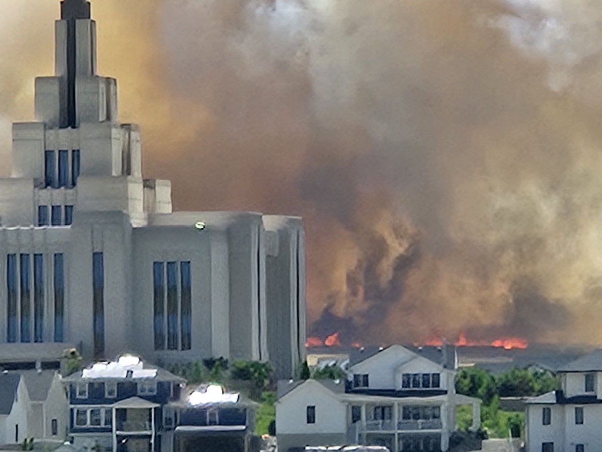
BREAKING: Fire burning in Saratoga Springs with high heat and wind.
Utah Fire Info has named this the #GlamertLaneFire
Evacuations are happening in the area of Mahogany Street and Roman Street.
Fire is estimated at 15-20 acres.
Strong winds are making suppression efforts difficult.
Multiple air and ground resources on scene. The cause of the fire is under investigation
Photo: Kurt Anderson
8
26
230
26,686
FireMap.live 🔥🌎 retweeted

May 29
Spinning out? We get it. 🌀
Landsat 8 captured these swirling clouds over the Southern Ocean on Feb. 11, 2026. The counterrotating spirals formed as flowing air was deflected by Peter I island and spun into eddies.
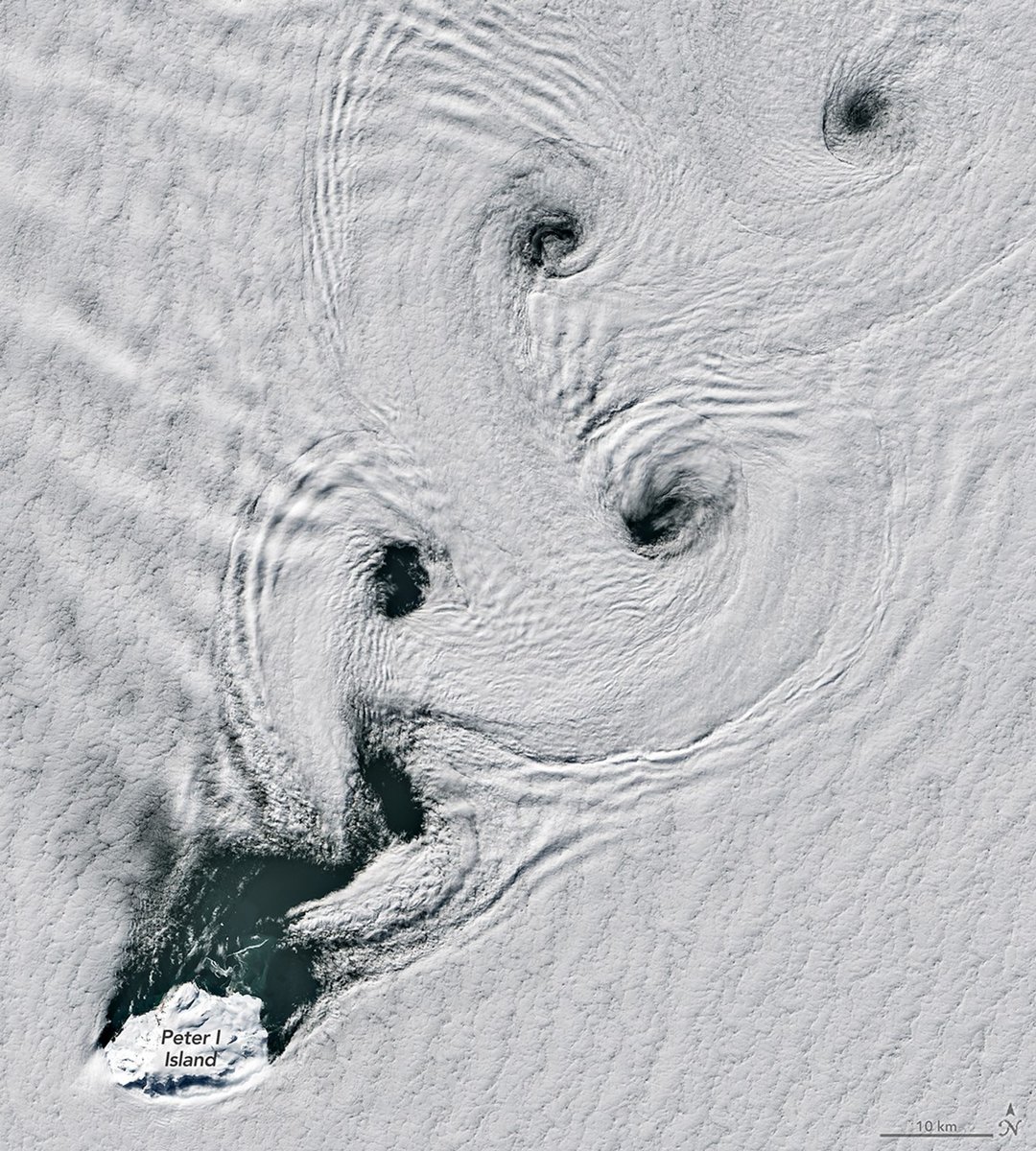
ALT Four spirals cut through a dense blanket of clouds over the Southern Ocean. In the bottom left corner is the icy island of Peter I. Credit: NASA
11
77
552
25,447
FireMap.live 🔥🌎 retweeted

May 25
🚨 #ChristyLaneFire UPDATE: The Red Canyon subdivision has been evacuated by the Iron County Sheriff’s Office. Evacuees are staged at Cedar City H.S.
Please avoid the area and follow directions from local officials so firefighters can safely continue protection efforts.
#UtahFire #ffslkw
1
4
31
3,929
FireMap.live 🔥🌎 retweeted
May 23
Magnitude 6.0 earthquake at 9:46 p.m. HST near Hōnaunau‑Nāpōʻopoʻo, Hawaiʻi Island. Strong shaking was widely felt across the islands. No apparent impacts to Mauna Loa or Kīlauea.
Minor to moderate damage is possible; please report any damage to Hawaiʻi County Civil Defense. Small aftershocks may continue.
More information: volcanoes.usgs.gov/hans-publ…
🗺️USGS Intensity map derived from felt reports and showing earthquake epicenter.
#USGS #Earthquake #Shaking

2
77
209
11,842
FireMap.live 🔥🌎 retweeted

May 21
During Wildfire Awareness Month, it’s important to recognize that some fire is intentional, carefully managed, and used to help reduce long-term wildfire risk and protect communities.
Fire is a natural part of many ecosystems, and when carefully planned under specific conditions, prescribed fire can be an important land management tool.
Prescribed fire helps reduce excess fuels, support healthier vegetation, and build more resilient landscapes. It can also improve wildlife habitat and help reduce the risk of more severe wildfires.
#WildfireAwarenessMonth
Video by Jeremiah Maghan
1
18
57
2,113

May 21
#SandyFire Evacuation warnings for Los Angeles County zones have been lifted and returned to normal status per @watchdutyapp.


1
6
1,004
FireMap.live 🔥🌎 retweeted

May 21
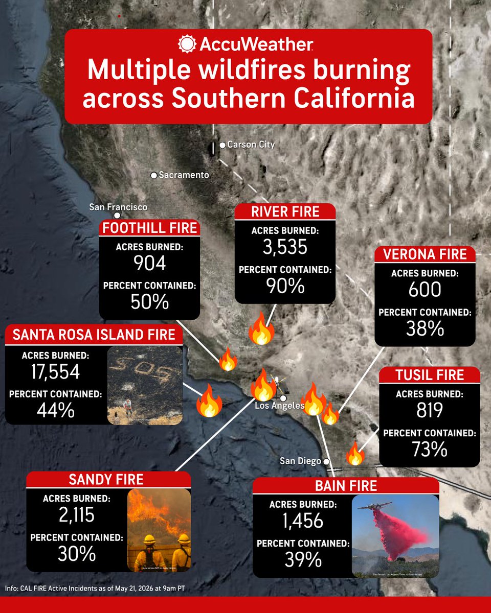
Multiple wildfires are burning across Southern California, forcing evacuations as dry, windy conditions fuel the flames. bit.ly/3RmwdVD
3
52
115
7,979
May 20
🤯

One of Southern California's remote, wild, sub-tropical islands is completely engulfed in flames and nobody is talking about it.
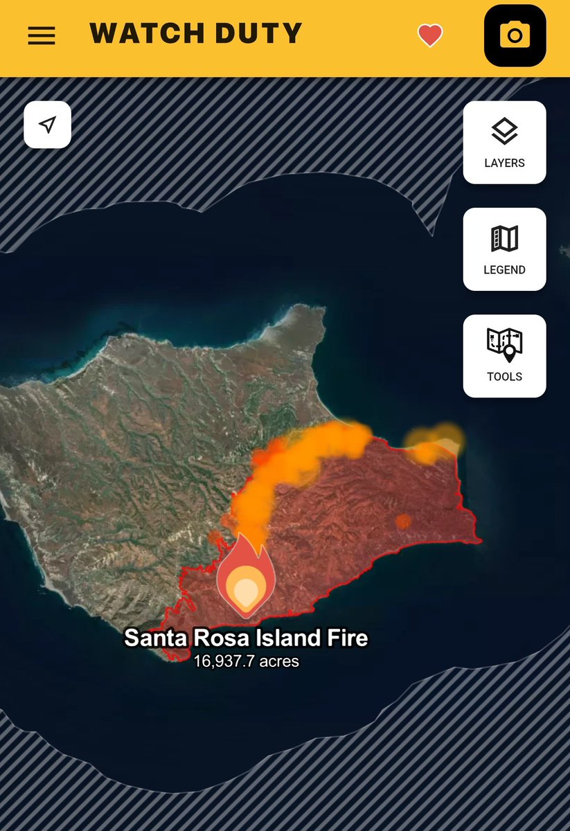
2
2
9
1,013
May 19
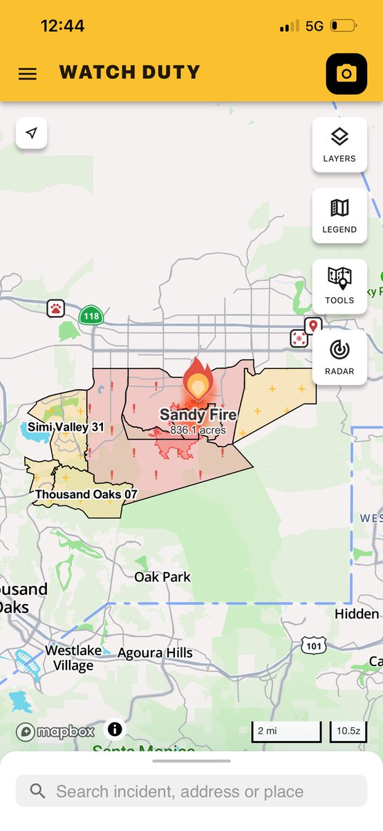
Aerial footage of #SandyFire Ventura County
May 19
Fast-moving updates on the #SandyFire west of West Hills — El Scorpion Park area and beyond. Have the Watch Duty app on and notifications enabled so you don’t miss an alert.
9
33
8,092
FireMap.live 🔥🌎 retweeted

May 19
#SandyFire it’s way too early in the year for this to be happening. Clear your brush, have a go bag, monitor WatchDuty and evacuate early.
14
46
204
9,777
May 18
The aircraft tracking on Watch Duty tells the whole story right now — the skies over the #SandyFire are busy. Huge respect for the pilots and crews working this fire. Stay safe out there.
2
5
43
4,060
May 19
Fast-moving updates on the #SandyFire west of West Hills — El Scorpion Park area and beyond. Have the Watch Duty app on and notifications enabled so you don’t miss an alert.
2
2
9
9,339
May 18
An Evacuation Warning has been issued for Zone Meier Canyon 01 per the Ventura County Emergency Incident Dashboard. The Zone is visible on the Watch Duty map.

1
4
595
May 18
New perimeter data for the #SandyFire is on FireMap now. The 3D view shows the landscape behind the fire line.
7
33
8,603

May 18
Sandy Fire seen from space.
x.com/rickdickertwx/status/2…
May 18

Smoke plume from the #SandyFire incident is now visible from space (22,300 miles up) via GOES WEST GeoColor composite imagery

2
9
1,590
FireMap.live 🔥🌎 retweeted

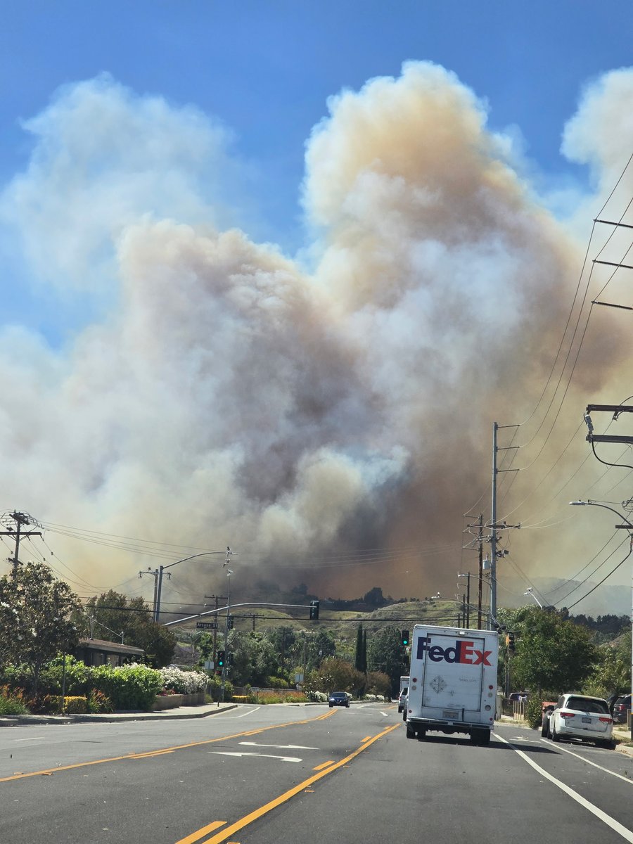
May 18
Sandy fire in Simi valley from my house

6
4
16
2,219
FireMap.live 🔥🌎 retweeted

The team at California Wildfire Tracking is now monitoring the #BurroFire in Los Angeles County. The Fire has a developing plume visible on nearby cameras and is 5 acres with a moderate rate of spread.

1
6
12
1,483