
May 20
#JUnit 6.1.0 is available!
🕑 Locale, time zone, & system property extensions
🚮 Configurable TempDir deletion strategy
🏃 org.junit.start module for compact source files
⚙️ Execution mode config for dynamic tests
🏊 New parallel test executor impl.
docs.junit.org/6.1.0/release…
6
13
1,053
Apr 25
#JUnit 6.1.0-RC1 is ready for testing!
✨ Built-in extensions for default locale, time zone, and system properties
🚮 Configurable TempDir deletion strategy
🧹 Experimental memory cleanup mode
docs.junit.org/6.1.0-RC1/rel…
5
22
3,182

21 Nov 2025
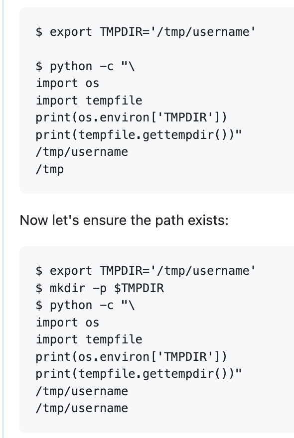
Just discovered python's `tempdir` silently ignores `TMPDIR` env var if the overridden path doesn't exist.
So you're likely to run into `No space left on device` with @huggingface `datasets` if your `/tmp` is smallish as it uses `tempfile` for almost everything.
I'm suggesting `datasets` work around this:
github.com/huggingface/datas…
2
3
21
2,185

3 Nov 2025
TwoSevenOneTが公開したEDR-Redir V2は、Windows 11でバインドリンクを悪用してEDRを欺き、Program FilesやProgramDataといった親フォルダを書き換える新手法で防御を回避する。
V2はEDRフォルダ直撃を廃し、Program FilesやProgramData等の親フォルダを列挙して攻撃者制御下のC:\TMP\TEMPDIRに対応フォルダを作成し、バインドリンクでループを作って親参照を差し替える。
実証でProgramData\Microsoft以下を差し替え、Windows Defenderの参照が攻撃者ディレクトリへ向きDLLハイジャックの経路が生じた。実行は標的・ターゲット・例外の三パラメータを取り、作成リンクをコンソール表示する。ツールはGitHubで公開されている。
gbhackers.com/edr-redir-v2-e…
1
9
1,332

3 Nov 2025
🛡️ New EDR-Redir V2 Blinds Windows Defender on Windows 11 With Fake Program Files
Read more: cybersecuritynews.com/edr-re…
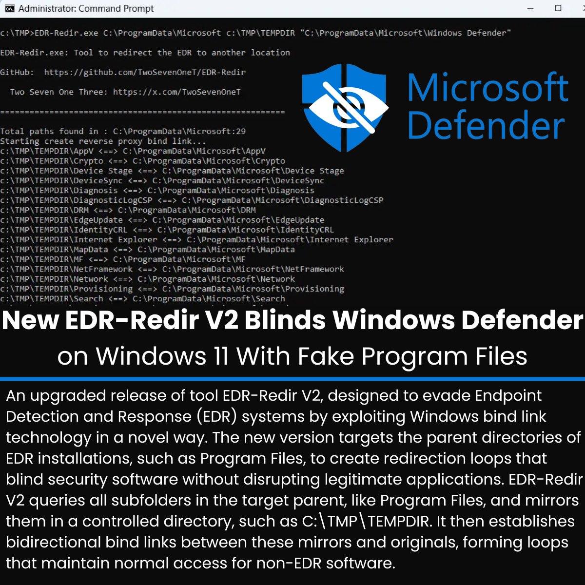
An upgraded release of tool EDR-Redir V2, designed to evade Endpoint Detection and Response (EDR) systems by exploiting Windows bind link technology in a novel way.
The new version targets the parent directories of EDR installations, such as Program Files, to create redirection loops that blind security software without disrupting legitimate applications.
EDR-Redir V2 queries all subfolders in the target parent, like Program Files, and mirrors them in a controlled directory, such as C:\TMP\TEMPDIR. It then establishes bidirectional bind links between these mirrors and originals, forming loops that maintain normal access for non-EDR software.
To Get Daily Security Updates, add Cyber Security News ® as your preferred source on Google -> lnkd.in/gtssq6QX
#cybersecuritynews
1
49
203
10,881

2 Nov 2025
【EDR回避技術】セキュリティ研究者TwoSevenOneTが開発したEDR-Redir V2ツールが、Windows 11のバインドリンク技術を悪用してWindows DefenderなどのEDRシステムを無力化する新手法を実証した。親ディレクトリレベルでリダイレクションループを作成し、正規アプリケーションの動作を妨げることなくセキュリティソフトを盲目状態にする。
従来のEDR-Redirは直接的なフォルダリダイレクションを使用していたが、保護機能により阻止されることが多かった。V2では、サブフォルダを自身にループバックさせながら、EDRのパスのみを隔離して操作する方式に進化した。この技術は、Windows 11 24H2で導入されたbindflt.sysドライバを利用し、カーネル権限なしでファイルシステム名前空間のリダイレクションを可能にする。
攻撃の仕組みは巧妙である。EDR-Redir V2はProgram Filesなどの親ディレクトリ内のすべてのサブフォルダを調査し、C:\TMP\TEMPDIRのような制御されたディレクトリにミラーリングする。これらのミラーと元のフォルダ間に双方向バインドリンクを確立し、EDR以外のソフトウェアの正常なアクセスを維持するループを形成。一方、Windows DefenderのC:\ProgramData\Microsoft\Windows Defenderなど、EDRの特定サブフォルダはループから除外され、攻撃者のTEMPDIRのみにリダイレクトされる。
Windows 11での実証では、EDR-Redir.exe C:\ProgramData\Microsoft c:\TMP\TEMPDIR "C:\ProgramData\Microsoft\Windows Defender"のパラメータで実行。実行後、DefenderはTEMPDIRを通じてループし、元のファイルにアクセスできなくなり、DLLハイジャッキングや悪意あるコンポーネントのロードが可能となった。この手法の単純さと効果により、企業環境での悪用リスクが懸念されている。
cybersecuritynews.com/edr-re…
2
47
224
18,785


10 Oct 2025
Just wrote a Bash script that makes full use of variables 💻⚙️
Instead of hardcoding stuff, I used variables like $art_name, $svc, $url, and $tempdir to make the script dynamic & reusable 🔁
Small tweak, big power move 😎💪
#Bash #Scripting #Linux #Automation #VAGRANT


5
256

11 Aug 2025
💡 R quick tip: Union multiple polygons into one shape
nl <- geodata::gadm(country = "Netherlands", level = 1, path = tempdir()) |> sf::st_as_sf()
nl_merged <- sf::st_union(nl)
plot(sf::st_geometry(nl_merged))
9
1,355
9 Aug 2025
In this case I would do the following:
country_sf <- geodata::gadm(
country = c("GBR", "IRL"), level = 0,
path = tempdir()
) |>
sf::st_as_sf() |>
sf::st_union() # merges all features into one multipart polygon
1
2
60

19 Jun 2025
Absolutely! Here are concise code examples for each key part of a Rust key-value system, from in-memory basics to persistent storage and distributed consensus.
1. In-Memory Key-Value Store (Single Node)
use std::collections::HashMap;
let mut store = HashMap::new();
store.insert("key1", "value1"); // set
let value = store.get("key1"); // get
store.remove("key1"); // delete
This is the simplest way to start, using Rust’s built-in HashMap for fast, in-memory operations.
2. Persistent Key-Value Store (Using rkv)
use rkv::{Manager, Rkv, SingleStore, Value, StoreOptions};
use rkv::backend::SafeModeEnvironment;
use tempfile::Builder;
use std::fs;
let root = Builder::new().prefix("simple-db").tempdir().unwrap();
fs::create_dir_all(root.path()).unwrap();
let path = root.path();
let mut manager = Manager::<SafeModeEnvironment>::singleton().write().unwrap();
let created_arc = manager.get_or_create(path, Rkv::new::<SafeModeEnvironment>).unwrap();
let env = created_arc.read().unwrap();
let store = env.open_single("mydb", StoreOptions::create()).unwrap();
let mut writer = env.write().unwrap();
store.put(&mut writer, "key1", &Value::Str("value1")).unwrap(); // set
writer.commit().unwrap();
let reader = env.read().unwrap();
let val = store.get(&reader, "key1").unwrap(); // get
store.delete(&mut writer, "key1").unwrap(); // delete
This example uses the rkv crate for a type-safe, persistent store.
3. Distributed Key-Value Store (Raft Consensus Layer)
For distributed setups, you’ll need to layer on a consensus protocol like Raft. Here’s a simplified snippet based on a Rust Raft implementation:
// Pseudocode: actual implementation will be more involved!
use raft_consensus::RaftNode;
let mut raft_node = RaftNode::new(/* config */);
raft_node.propose_set("key1", "value1"); // replicated set
let value = raft_node.get("key1"); // replicated get
raft_node.propose_delete("key1"); // replicated delete
This structure ensures consistency and fault tolerance across nodes, using crates like raft-consensus and persistent engines like sled.
Let me know if you want deeper examples for networking, serialization, or error handling!
22

18 Jun 2025
🚑 Phel v0.18.1 is out!
Introducing the doctor command 🩺, PHAR fixes 🛠️, and custom tempDir support 🗂️
A smoother and more stable PHAR experience awaits!
Changelog: github.com/phel-lang/phel-la…
#phel #lisp #phar #php #opensource #functional
3
5
269

11 Apr 2025
#JUnit 5.12.2 has been released.
🐞 Fix regression when using CleanupMode.ON_SUCCESS with @TempDir
junit.org/junit5/docs/5.12.2…
1
3
192
8 Apr 2025
1️⃣2️⃣ Access population density data using wpgpDownloadR. This example fetches data for Nepal from 2020 for planning and risk assessments.
Why it matters: Understanding population density is key for urban planning and resource allocation.
💻 # 10. Population density
#-----------------------
# install and load packages
remotes::install_github("wpgp/wpgpDownloadR")
pacman::p_load(wpgpDownloadR, terra)
# Download 2020 population density data for Nepal
pop_data <- wpgpDownloadR::wpgpGetCountryDataset(
ISO3 = "NPL", # Nepal
covariate = "ppp_2020",
destDir = tempdir()
)
# Load the raster data
pop <- terra::rast(pop_data)
# Plot population density
terra::plot(pop)
1
6
1,076
8 Apr 2025
9️⃣ Pull average temperature data from WorldClim using geodata for any country to study climate conditions.
Why it matters: Temperature data is essential for climate change analysis, agriculture, and urban planning.
💻 # 7. WorldClim data
#------------------
# install and load packages
pacman::p_load(geodata, tidyverse)
# Fetch average temperature data for Turkey
avg_temperature <- geodata::worldclim_country(
country = "TUR",
var = "tavg",
res = .5,
path = tempdir()
)
class(avg_temperature)
# Plot temperature data (using tidyterra for spatraster)
ggplot()
tidyterra::geom_spatraster(data = avg_temperature[[12]])
scale_fill_gradientn(colors = rainbow(16, rev = TRUE))
theme_minimal()
labs(title = "Average Temperature (WorldClim)", fill = "Temp (°C)")
1
3
419
8 Apr 2025
7️⃣ Fetch DEM for any country in the world using elevatr to analyze terrain, flood risks, and infrastructure planning.
Why it matters: DEMs are crucial for environmental studies and engineering projects.
💻 # 5. AWS Terrain Tiles digital elevation model
#---------------------------------------------
# install elevatr and load packages
pacman::p_load(elevatr, geodata, tidyverse, terra)
# get Switzerland's boundary (area of interest)
locations <- geodata::gadm(
country = "CHE",
level = 0,
path = tempdir()
) |> sf::st_as_sf()
# if error occurs, try again
locations <- geodata::gadm(
country = "CHE",
level = 0,
path = tempdir()
)
locations <- sf::st_as_sf(locations)
# fetch the DEM (z = zoom level 8)
elevation_country <- elevatr::get_elev_raster(
locations = locations,
z = 8, clip = "locations"
)
# plot DEM
terra::plot(elevation_country)
1
6
467
8 Apr 2025
5️⃣ Using rstac, query Microsoft’s Planetary Computer for ESA World Cover 2021 data focused on Bangladesh.
Why it matters: Land cover information is critical for environmental monitoring and land-use analysis.
💻 # 3. ESA World Cover 2021
#------------------------
# install rstac and load required packages
pacman::p_load(rstac, geodata, sf)
# fetch Bangladesh boundary (polygon of interest)
bangladesh <- geodata::gadm(
country = "BGD",
level = 0,
path = tempdir()
) |> sf::st_as_sf()
# if error, try again:
bangladesh <- geodata::gadm(
country = "BGD",
level = 0,
path = tempdir()
)
bangladesh <- sf::st_as_sf(bangladesh)
# define area of interest from the polygon
bbox <- sf::st_bbox(bangladesh)
# query Microsoft Planetary Computer for ESA World Cover 2021
ms_query <- rstac::stac("planetarycomputer.microsoft.…")
ms_esa_query <- rstac::stac_search(
q = ms_query,
collections = "esa-worldcover",
datetime = "2021-01-01T00:00:00Z/2021-12-31T23:59:59Z",
bbox = bbox
) |> rstac::get_request()
# sign in to the MS Planetary Computer
ms_query_signin <- rstac::items_sign(ms_esa_query, rstac::sign_planetary_computer())
# Download ESA World Cover 2021 for Bangladesh
rstac::assets_download(
items = ms_query_signin,
asset_names = "map",
output_dir = tempdir(),
overwrite = TRUE
)
1
4
577

2 Apr 2025
Tired of writing tempdir()/tempfile() code in your #rstats package examples to be compliant with CRAN's file policy?
Get CRAN-compliant file examples with a single #roxygen2 tag: examplesTempdir.
📝 Read more: blog.thecoatlessprofessor.co…
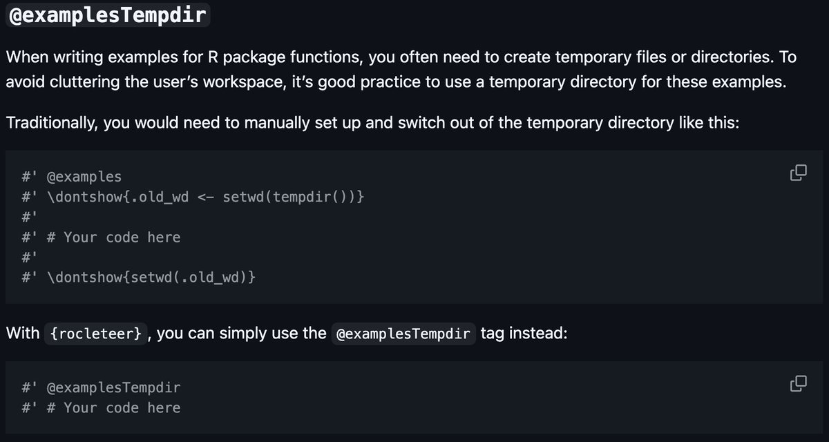
ALT Screenshot showing the @examplesTempdir feature for R packages. The image compares two approaches for managing temporary directories in package examples. The traditional method requires multiple lines of code with setwd(tempdir()) and cleanup commands. With the {rocleteer} package, this can be simplified to a single @examplesTempdir tag. The image shows code examples of both approaches, highlighting how the new method reduces boilerplate code. Old approach: #' @examples #' \dontshow{.old_wd <- setwd(tempdir())} #' #' # Your code here #' #' \dontshow{setwd(.old_wd)} New approach: #' @examplesTempdir #' # Your code here
7
17
610

18 Mar 2025
4 Underutilized Unit Test Annotations You Might Not Know About ✅
- Timeout: This annotation helps ensure your tests don't hang or take too long to execute.
- RepeatedTest: Helps identify these flaky tests by running them multiple times.
- ParameterizedTest: This combined with various source annotations can make your tests more comprehensive and maintainable.
- TempDir: It automatically manages temporary directories for your tests.
1
2
22
987