
Meteorologist @wibw | Formerly @wbrcnews | @msstate Alum | Follow Me On Social Media: @mitchellkeyeswx
Joined March 2021
- Tweets 5,301
- Following 1,923
- Followers 1,358
- Likes 4,714
1,832 Photos and videos


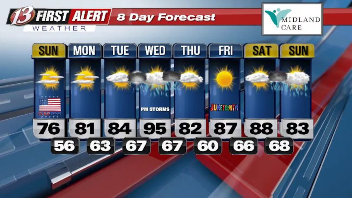


Highs in the 70s today, near 80 Monday with cooler, dry weather. Isolated showers/storms Monday night and Tuesday night. Hot Wednesday with widespread storms; a few may be severe Wednesday afternoon/evening, lingering into early Thursday.
1
1
94
A beautiful double rainbow appeared behind the line of storms that moved through the Capital City this evening as seen from the WIBW TV Station. #kswx
1
42
Highs stay in the 70s for most spots today and Monday with cooler, dry weather. A few showers and storms are possible Monday night and Tuesday night, but coverage stays low.
1
1
2
172
Wednesday turns hot, with widespread storm chances, with some possibly being severe, developing Wednesday afternoon and evening and lingering into early Thursday.
26
FIRST ALERT FORECAST: Cooler, Dryer Today & Monday; Heat & Storms Return Midweek Wednesday Into Early Thursday
Read Our First Alert Forecast! ⬇️
1
1
2
136
Highs stay in the 70s for most spots today and Monday with cooler, dry weather. A few showers and storms are possible Monday night and Tuesday night, but coverage stays low.
1
35
Wednesday turns hot, with widespread storm chances, with some possibly being severe, developing Wednesday afternoon and evening and lingering into early Thursday.
22
Just a reminder to any chasers, trackers, etc. moving through Topeka, KS. I-70 is closed through downtown. #wx #wxtwitter
1
122
First Alert Weather Day 6/13: Severe storms possible 3–11 PM; where they form first is uncertain. Threats: golf-ball hail, 60–80 mph winds, and a tornado or two. Heavy rain (2–4" ) may cause flash flooding, esp. east-central KS. Flood Watch thru Sun AM.
1
2
759
Severe storms are likely this afternoon and evening, but where they form first is still uncertain. The main severe window is 3–11 PM, with golf-ball size hail,60–80 mph winds, and a tornado or two possible.
1
1
2
587
Very heavy rain could drop 2–4 inches (locally higher) and cause flash flooding, especially in east-central Kansas, with a Flood Watch through Sunday morning.
1
102
Storm chances may linger tonight, then it turns milder and drier Sunday through Tuesday. Warmer weather returns Wednesday with another storm chance and possible severe impacts.
100
First Alert Weather Day: Severe Storm And Flooding Risk Today Into Tonight
Read Our First Alert Forecast! ⬇️
1
1
1
285
Very heavy rain could drop 2–4 inches (locally higher) and cause flash flooding, especially in east-central Kansas, with a Flood Watch through Sunday morning. Storm chances may linger tonight, then it turns milder and drier Sunday through Tuesday.
1
51
Warmer weather returns Wednesday with another storm chance and possible severe impacts.
42