
Estudio la intersección entre geografía y justicia en @IGeografiaUNAM. Profe @ENCiT_UNAM. #19S #Desastres #Geodata. Comité Científico @IRDR_IPO. @developmentuea
Joined April 2009
- Tweets 7,624
- Following 4,934
- Followers 3,275
- Likes 17,727
337 Photos and videos


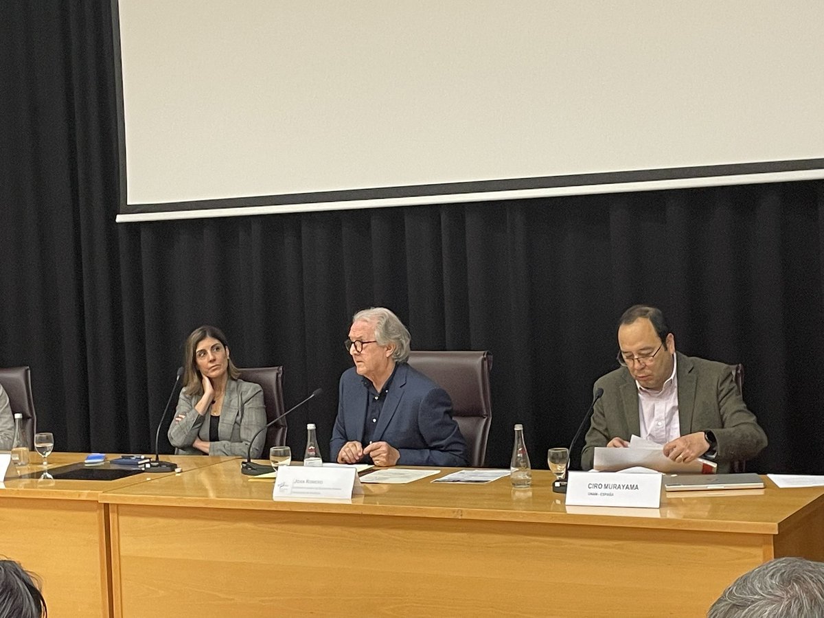


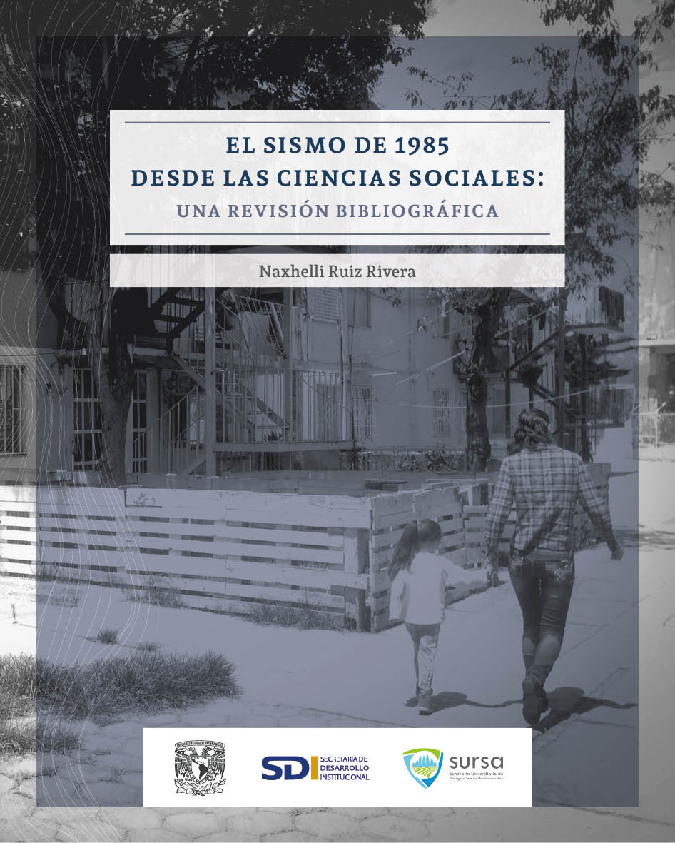
📚Ayer 17/09 presentamos en el @IISUNAM la publicación "El sismo de 1985 desde las ciencias sociales: una revisión bibliográfica", editado por @SURSA_UNAM
Son 293 libros, artículos y otras publicaciones de ciencias sociales de los últimos 40 años
Abro 🧵
tinyurl.com/5csjtm73
6
89
229
11,433
Naxhelli retweeted

Si estás interesada en participar en política🇲🇽 #Elecciones2027, ¡esta convocatoria es para ti!
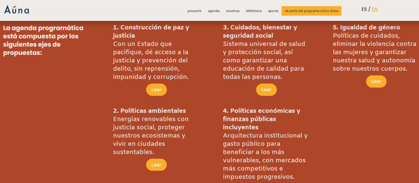
En @AunaMexico fortalecemos capacidades de mujeres p impulsar una agenda común:
Paz y justicia
Políticas Ambientales
Igualdad de género
Economía incluyente
Cuidados
Diversas y juntas

📣 Ya está abierta la Convocatoria Nominadas Aúna 2026–2027
¿Buscas contender a un cargo de elección popular en 2027? En Aúna te acompañamos con formación, agenda colectiva, coaching político y una red plural de mujeres* que construyen otra forma de hacer política.
¿Conoces a alguna mujer* con el potencial y liderazgo para incidir en la vida pública de México? Menciónala aquí e invítala postularse 👇
El registro cierra el 21 de junio
tr.ee/HjF9je
#NominadasAúna #AÚNASomos


1
7
13
719
Naxhelli retweeted

Jun 14
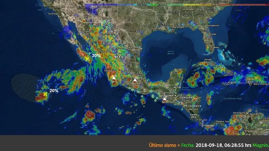
The best flood-mapping AI may be the one we stop allowing to invent impossible water.
Most satellite flood maps do one thing well: they show where the water appears to be. Take Sentinel-1 radar, add optical imagery when clouds allow, classify each pixel, and produce a flood mask.
I guess that’s useful during a disaster, but it leaves out some pretty important factors - how deep the water is, how fast it’s moving, and whether the flood pattern makes physical sense.
A new paper tackles that harder problem.
They present a model which combines Sentinel-1 radar, Sentinel-2 optical imagery, and terrain information from a digital elevation model. That terrain layer includes elevation, slope, and HAND, which measures how high each location sits above the nearest drainage path.
Then the authors use a hybrid architecture: UNet plus FNO.
UNet is pretty good at local details. It can pick up flood edges, roads, urban structure, and small changes in inundation patterns. FNO is better at broader spatial relationships, such as upstream-downstream structure and basin-scale flow.
That combination is useful because floods don’t happen at one scale. A road embankment can shape the water in one neighbourhood, while the slope of the whole floodplain controls where the water wants to go.
But what I find to be the strongest part of the paper is the discussion on physics loss.
The model predicts water depth and velocity, then training checks those predictions against the depth-averaged shallow-water equations. In plain terms, the model gets penalised when it draws floodwater that looks plausible in an image but breaks the rules of mass, momentum, slope, and friction.
That constraint appears to do real work.
Across three held-out floodplain regions, the hybrid model reached an IoU of 0.82 and an F1 score of 0.90.
The depth results are more interesting. Evaluated against HEC-RAS hydrodynamic simulations, the hybrid model reached a water-depth RMSE of 0.21 m.
For flow velocity, the hybrid model reached 0.15 m/s RMSE. It also kept relative mass imbalance down to 2.1%, which is exactly the kind of check you want when a model is pretending to understand water.
Anyway, it looks like the trend is that flood AI models is moving from image classification to physical state estimation. This essentially resembles more traditional hydraulic modelling approaches to the problem. Maybe we're coming full circle...
Link to paper: arxiv.org/pdf/2606.06524
(Image source: UN Spider)

5
10
96
6,358
Naxhelli retweeted

Jun 13
GeoLibre v1.2.0 is here!
GeoLibre is a free and open-source, lightweight, cloud-native GIS platform for visualizing, exploring, and analyzing geospatial data. One application that runs everywhere: in your web browser, as a native desktop app, on your phone, and inside a Jupyter notebook. No account, no server, no cost. Everything runs locally and your data stays private.
This release packs in 35 pull requests of new capabilities. A few highlights:
- Run SQL right in the browser. The SQL Workspace pairs DuckDB Spatial with a new in-browser PostGIS engine (PGlite), so you can query layers, local files, and remote URLs without a server.
- A smarter attribute table. Add fields, run a field calculator, and explore your data with a built-in Charts panel (histogram, scatter, bar, line, and box plots).
- More ways to add data. OpenStreetMap PBF extracts, Cloud-Optimized NetCDF/HDF via kerchunk, georeferenced video overlays, authenticated 3D Tiles, and a deck.gl Layer builder for custom overlays.
- Better visualization. Heatmap rendering, point clustering, and H3 hexagonal grids for spatial binning.
- New analysis and routing. A Directions plugin, plus Spatial Join, Select by Value, and Select by Location vector tools.
- Print and share. A print layout composer that exports your map to PNG or PDF.
- Work faster. A command palette (Ctrl/Cmd K), global keyboard shortcuts, and undo/redo for layer and style operations.
- Built for everyone. New internationalization framework, an accessibility pass with automated axe checks, an installable offline-capable PWA web build, React error boundaries, and Playwright end-to-end tests.
Try the live demo: viewer.geolibre.app
Star it on GitHub: github.com/opengeos/GeoLibre
Docs and roadmap: geolibre.app
Release notes: github.com/opengeos/GeoLibre…
#GIS #OpenSource #Geospatial #MapLibre #WebGIS #DuckDB #GeoLibre
13
116
742
37,984
Naxhelli retweeted
Les comparto "Duelo y transformación: un plan para restaurar la paz a través de la transparencia y la claridad".
Esta publicación la dedico a las madres buscadoras en México. Resilientes, compasivas, dolientes y transformadoras.
academia.edu/168598978/Duelo…


1
2
96
Naxhelli retweeted
Pasar de las ideas a la acción, es el reto de las democracias.
¿Quieres abonar?
El Congreso Internacional de Estado Abierto y Gobernanza, es un estupendo foro para ello.
Presenta tu propuesta. Coordino el eje de Estado Abierto y Derechos Humanos, con Mariol Virgili de Chile

¿Ya revisaste las subtemáticas del Congreso Internacional de #EstadoAbierto y #Gobernanza?
Temas:
👥Estado abierto y #DDHH
🛜Gobernanza ética de la tecnología
🏛️Crisis de #democracia y retos globales
⚖️Integridad y buen gobierno
Postula hasta 2️⃣0️⃣ junio congresoestadoabierto.com


5
10
297
Naxhelli retweeted

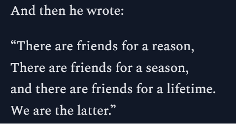
Such a lovely tribute to @raulpacheco by Christiana Zenner.
She encapsulated why Raul left such a deep void amongst the academic community and his friends.
And in Raul's own words, he explained it rather well💔christyzen.substack.com/p/ra…
8
26
735
Naxhelli retweeted

Jun 11
las más de 134 mil personas que siguen desaparecidas en méxico llenarían 1.5 veces el estadio azteca de ciudad de méxico, 2.5 veces el estadio bbva de monterrey y 2.7 veces el estadio akron de guadalajara.
4
310
1,487
17,052
Naxhelli retweeted

Jun 11

14
3,047
25,362
177,048
Naxhelli retweeted

🎓 ¡Curso GRATUITO de @FAOCampus!
🌍Planificación geoespacial en proyectos de desarrollo territorial.
Conoce la metodología Mano de la Mano, mejora tus proyectos y comunícalos con mapas.
¡Matricúlate! ➡️f.mtr.cool/tvccqlmsjc
#HandInHand #FAO #SIG #DesarrolloTerritorial

1
48
148
4,762
Naxhelli retweeted

Jun 9
Yo trabajando en un artículo con 37 PDFs abiertos.

20
2,369
14,525
154,845
Naxhelli retweeted
Jun 9
GeoLibre v0.9.0 is out.
GeoLibre is a lightweight, cloud-native GIS platform for visualizing, exploring, and analyzing geospatial data across desktop and web environments, with a responsive layout for mobile screens.
This release turns GeoLibre into a far more complete analysis environment. Highlights:
- New cloud data panels for Microsoft Planetary Computer and Google Earth Engine, plus an Overture Maps plugin and federal Web Services plugins, including NASA Earthdata, USGS National Map, EPA EnviroAtlas, FEMA NFHL
- Accessing 1000 NASA Earthdata layers with a few simple clicks
- Time Slider plugin for animating time series raster and vector data
- SQL Workspace: run DuckDB Spatial SQL directly against loaded layers, local files, and remote URLs, with query history and one-click "add results to map"
- Conversion tools: Vector to GeoParquet, CSV to GeoParquet, and Raster to COG, running in the browser with DuckDB-WASM
- Controls menu with Measure, Bookmark, Minimap, View State, and Print
Everything is open source. Try it in your browser, install the desktop app, or self-host it.
Live demo: viewer.geolibre.app/?url=sha…
GitHub: github.com/opengeos/GeoLibre
Feedback and contributions are welcome.
#GIS #Geospatial #OpenSource #MapLibre #DuckDB #WebGIS #GeoLibre
10
130
784
41,369
Naxhelli retweeted

📘 Tutorial de R para ciencias sociales.
Una introducción a herramientas computacionales siguiendo un ejercicio de investigación sobre el sentido social del big data:
📊 datos
📝 texto y sentimientos
🧠 tópicos
🤖 clasificación
🕸️ APIs y webscraping
🔗 bookdown.org/gaston_becerra/…

78
299
9,233
Naxhelli retweeted

Jun 8
📢 Diversos colectivos y organizaciones anunciaron una megamanifestación para el próximo 11 de junio de 2026, día de la inauguración del #Mundial2026 en la Ciudad de México.
La movilización contempla la participación de madres buscadoras, trabajadores de la educación, pensionados de Pemex y CFE, transportistas, organizaciones campesinas y trabajadores de la salud.

141
1,582
3,193
200,687
Naxhelli retweeted

Jun 9
La CDMX no tiene por qué estar lista para el mundial. Debe estar siempre lista para los que vivimos aquí. Llevamos casi 30 años de retraso.
118
2,674
20,293
192,088
Naxhelli retweeted

El cambio de uso de suelo por la urbanización altera el clima local. Los materiales que componen los elementos arquitectónicos de la ciudad absorben más radiación de onda corta y la emiten como calor, dando lugar al fenómeno de la isla de calor urbana (ICU).

1
7
27
527
Naxhelli retweeted

El decreto es revelador: para la inauguración del Mundial se suspenden clases y se promueve el trabajo remoto.
Después de millones en obras, la solución sigue siendo la misma: que la gente deje de usar la ciudad para que la ciudad funcione.
#Mundial2026
Jun 9

⚽️ Gobierno decreta “quédate en casa” que llega el Mundial
El Gobierno publica en el DOF el Decreto por el que se establecen diversas medidas administrativas en el marco de la celebración de la “inauguración de la Copa Mundial de la FIFA 2026” en la Ciudad de México
Con este documento el Gobierno federal establece el ‘home office’ para algunas actividades, exhorta al sector privado a hacer lo mismo y suspende clases el 11 de junio, solamente en la capital del país.

6
74
226
11,125
Naxhelli retweeted

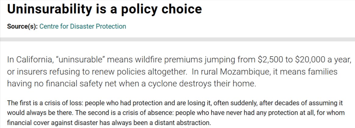
📖 Uninsurability is a Policy Choice by Centre for Disaster Protection
Perhaps the most provocative read of the three.
The article argues that being "uninsurable" is not simply a market outcome. It reflects policy decisions about who gets protected and who bears #risk.
1
2
1
313
Naxhelli retweeted

Jun 5
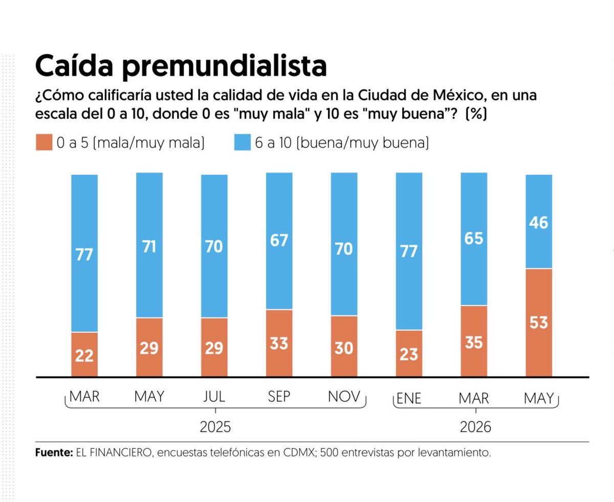
Dos apuntes sobre el dato que comparte Alejandro Moreno:
(1) El indicador de valoración social de la calidad de vida, es mucho más interesante que la aprobación positiva o negativa de la gestión. Es el malestar social.
(2) Alguien en el gobierno capitalino, no está leyendo bien —en el sentido político, no estadístico— las encuestas.
No es solo el “tren del mame” o “la molestia con el morado” o un “asunto de clase”. Está creciendo el malestar social. Habrá que tomárselo en serio.

#LasEncuestas La calidad de vida en CDMX.
Se desploma valoración positiva justo antes del Mundial. elfinanciero.com.mx/opinion/…
1
22
78
7,827
Naxhelli retweeted

Jun 5
Por qué las obras de remodelación del metro están a marchas forzadas? La administración de @AdrianRubalcava hizo la contratación el 29 de abril y además:👇🏽
Metro CDMX simuló competencia en licitación pública por 113 mdp a 43 días del Mundial 2026 grupoanimal.mx/estados/metro…
17
628
1,077
13,921