OKC OEM conducts public education/outreach programs to support community resilience & enhance disaster preparedness.Questions: okcem@okc.gov Emergency: Dial 911
Today will be another hot and humid day across the area, particularly for portions of northern Oklahoma.
Make sure to exercise caution if you plan to engage in outdoor activity during the heat of the day.
#okwx#texomawx
3
29
3,097
OKC Office of Emergency Management (OKC OEM) retweeted
Not a big fan of the heat? Hang in there. Today, tomorrow, and Thursday will continue to be oppressive, but there is an increasingly strong signal for temperatures to cool off by 5-10 (maybe even 15 in spots) degrees early next week.
5
26
2,925
OKC Office of Emergency Management (OKC OEM) retweeted
Hot and humid conditions will occur tomorrow afternoon with heat index values above 100 °F for many locations. In addition, there is a low chance for thunderstorms across northwest and west central Oklahoma with the primary hazard being strong winds. #okwx#texomawx
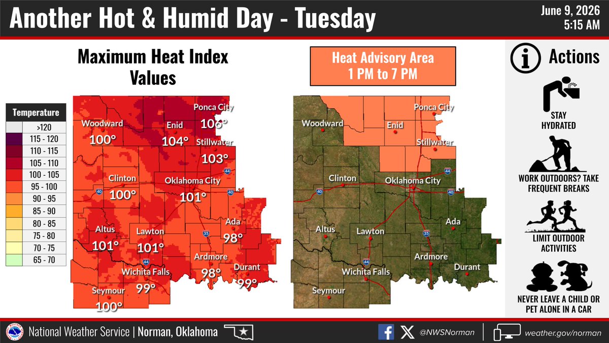
ALT These are the forecast heat index values for Monday afternoon.
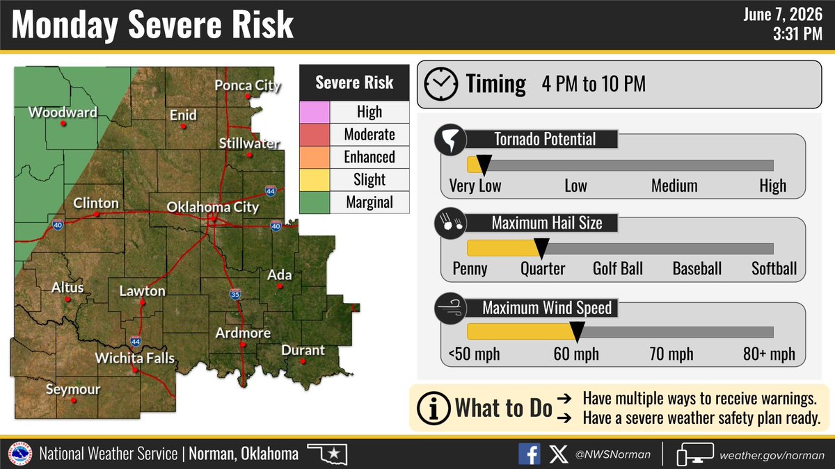
ALT This is the risk for severe weather Monday afternoon into the evening.
4
32
5,253
OKC Office of Emergency Management (OKC OEM) retweeted
Our first stretch of summertime hot and humid conditions arrives across the area this week.
Generally low chances for rain and storms early in the week gives way to greater coverage from Thursday onward into the upcoming weekend.
#okwx#texomawx
Severe thunderstorms are possible later this afternoon and evening. Timing for storms to develop is after 3 PM today, but this morning is a good time to review severe weather plans and be ready for warnings. #okwx#texomawx
ALT This risk for severe weather on Wednesday.
2
15
66
6,659
OKC Office of Emergency Management (OKC OEM) retweeted
Low chances of thunderstorms return early afternoon and increase after 3PM across western and north-central Oklahoma. Rain is likely by early evening for most areas before exiting our area early Thursday morning.
#okwx#texomawx
1
5
45
6,498
OKC Office of Emergency Management (OKC OEM) retweeted
Severe weather is possible this week! Stay weather aware and tune in daily for updates from NWS or local media. Now is the time to prepare for severe weather.
#okwx#WXprep#ReadyOK
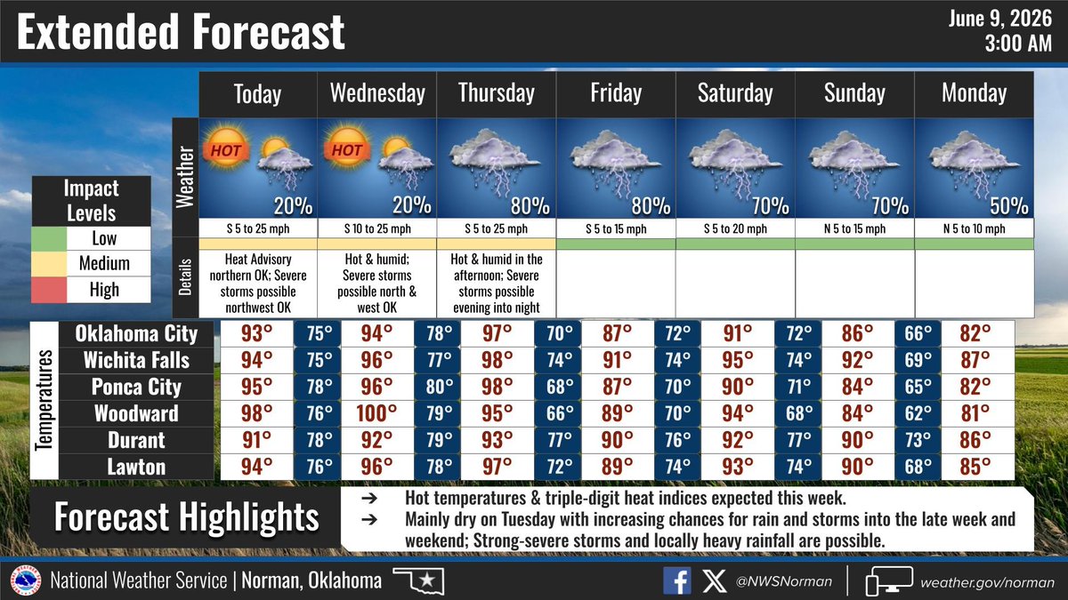
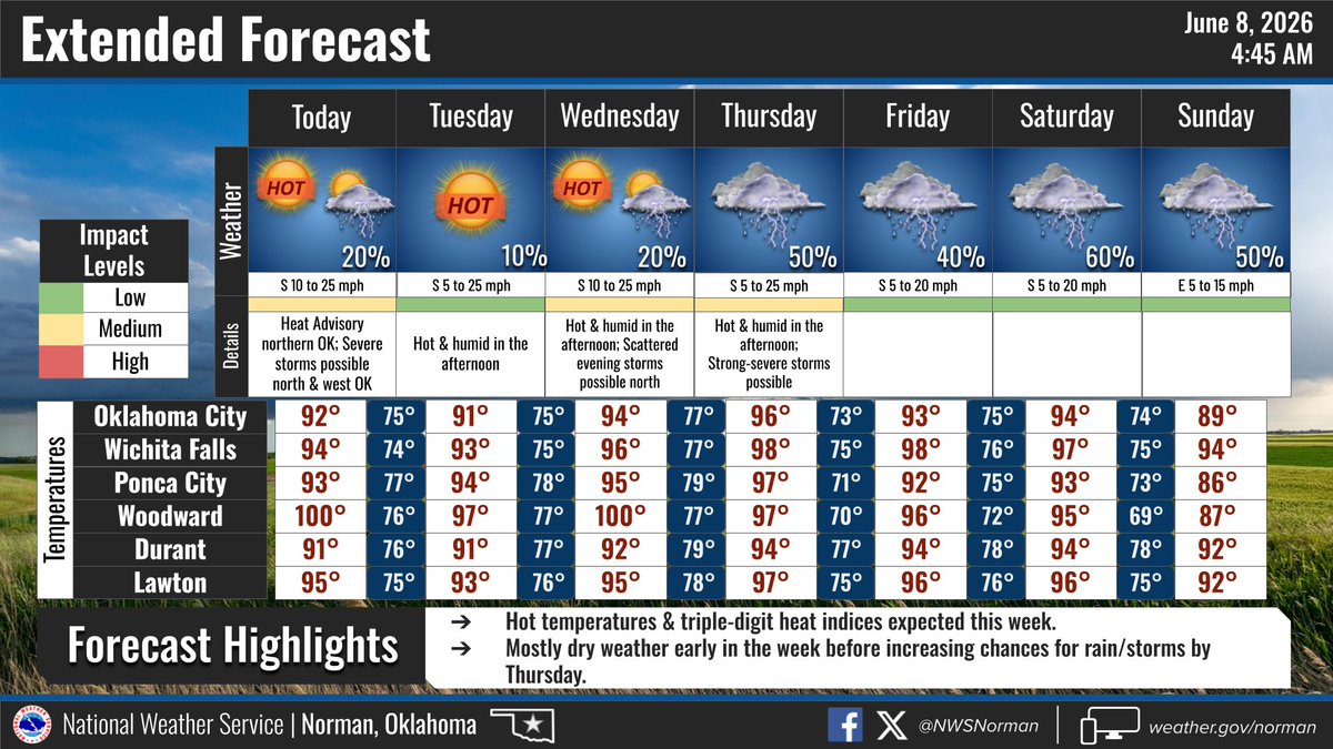
ALT Severe Weather Possible through Friday. Be #ReadyOK
2
4
5
585
OKC Office of Emergency Management (OKC OEM) retweeted
Elevated to near critical fire weather conditions will be expected Tuesday afternoon across much of the area. With vegetation already very dry across the entire area, make sure you are doing your part to prevent fires from starting! #okwx#txwx
2
9
31
2,783
OKC Office of Emergency Management (OKC OEM) retweeted
Fire weather danger continues today across Oklahoma and north Texas with the worst conditions late morning into the afternoon. A cold front will gradually shift the winds from the west to the northwest and to the north this afternoon and evening as it moves south. #okwx#texomawx
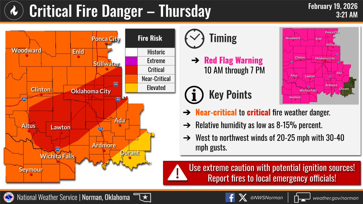
ALT This graphic depicts information on fire categories and a Red Flag Warning on Thursday.
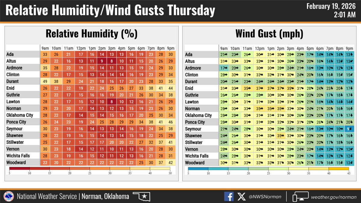
ALT This graphic displays the forecast relative humidity and wind gusts on Thursday.
7
27
6,562
OKC Office of Emergency Management (OKC OEM) retweeted
With fire weather conditions continuing today, it is important to practice wildfire safety as all it takes is one spark to cause a wildfire. Here’s some important information on what causes wildfires: #okwx#texomawx
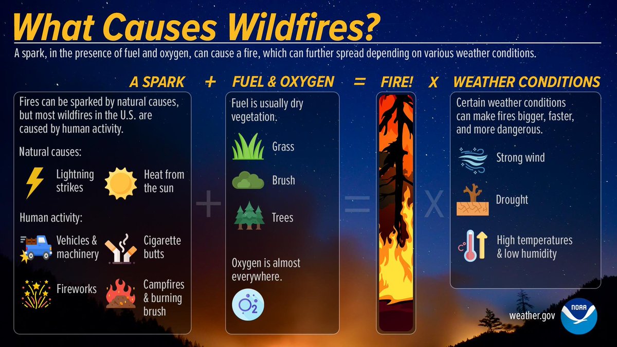
ALT Here's some information on what cases wildfires.
7
15
2,568
OKC Office of Emergency Management (OKC OEM) retweeted
Elevated to near critical fire weather conditions are expected Monday afternoon as temperatures rise into the upper 70s to low 80s °F with breezy winds. The worst fire weather conditions will be across northwest Oklahoma, where the lowest humidity is forecast. #okwx#texomawx
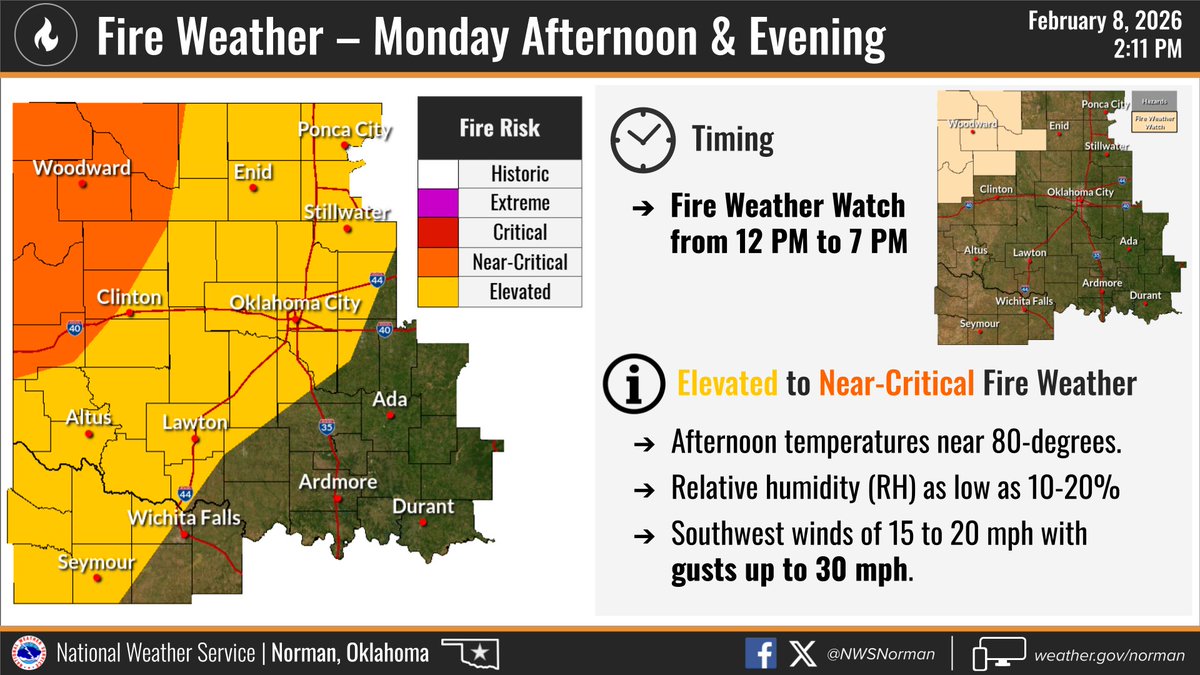
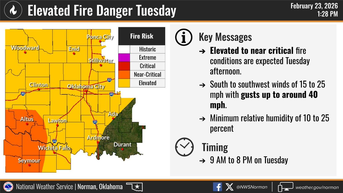
ALT The following graphic displays information on a risk for fire weather on Monday, February 9th, 2025.
3
26
4,470
OKC Office of Emergency Management (OKC OEM) retweeted
For those of you who have had enough of winter the past couple weeks (raises hand 🙋♂️), much warmer temperatures are on the way! Highs in the 60s and 70s are in the forecast for much of the area, which will be up to 20 degrees above normal for this time of year. #okwx#txwx
3
7
60
4,392
OKC Office of Emergency Management (OKC OEM) retweeted
Friendly reminder to heat your home safely to prevent an accidental fire!
✅ Keep things that can burn 3 feet from heat sources
🔌 Plug space heaters directly into outlets
❌ Never use your oven to heat your home
💤 Turn off heating sources when you leave the room or go to sleep
#FireSafety@MEM_Fire@CityOfMemphis
15
15
4,821
OKC Office of Emergency Management (OKC OEM) retweeted
Temperatures are expected to drop below freezing again tonight (they already have in much of northern and western OK). This means any liquid left from yesterday's melting will refreeze. Be careful this morning and watch out for black ice. #okwx#texomawx
ALT Thursday night's low temperatures.
1
3
38
3,835
OKC Office of Emergency Management (OKC OEM) retweeted
We didn't get any new snow last night, but secondary/rural roads that didn't get fully cleared yesterday have refrozen overnight.
Give yourself extra time today and remember to always leave extra distance between yourself and other vehicles on icy roads.
3
43
4,083
OKC Office of Emergency Management (OKC OEM) retweeted
Greatest snow accumulations (>6") expected across north/central OK. These snow totals include sleet accumulations of up to 2" across portions of south central/S OK & western N TX. Greatest chances for ice is expected from western N TX into S OK with a corridor of 0.25" possible.
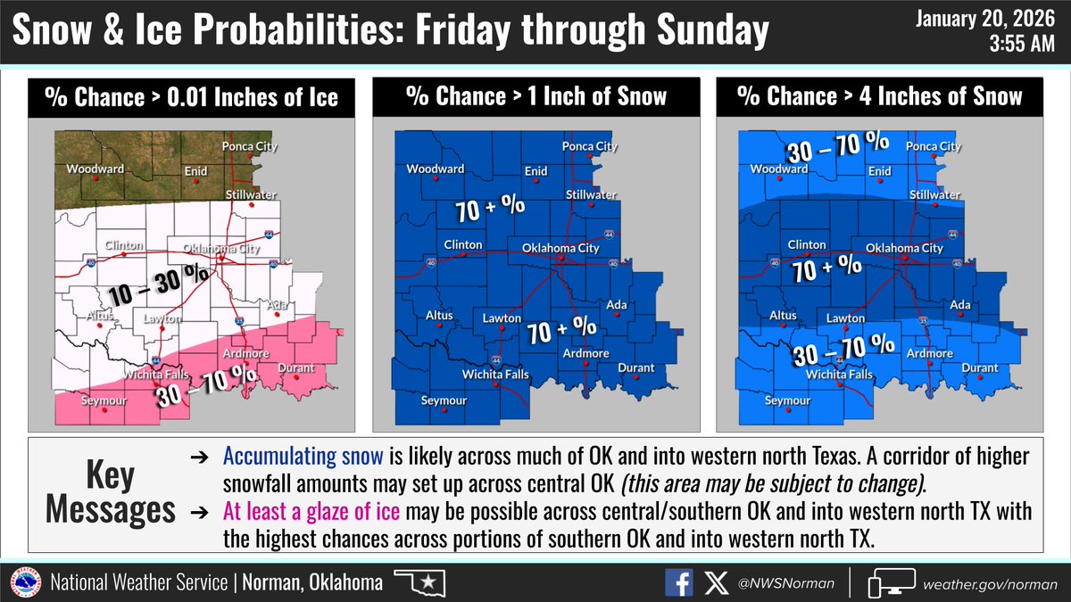
ALT The graphic displays the snowfall and ice amounts for Friday through Sunday.
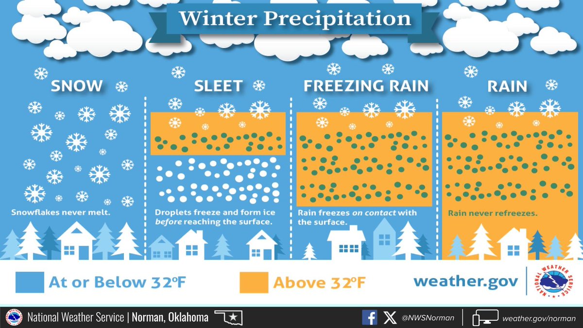
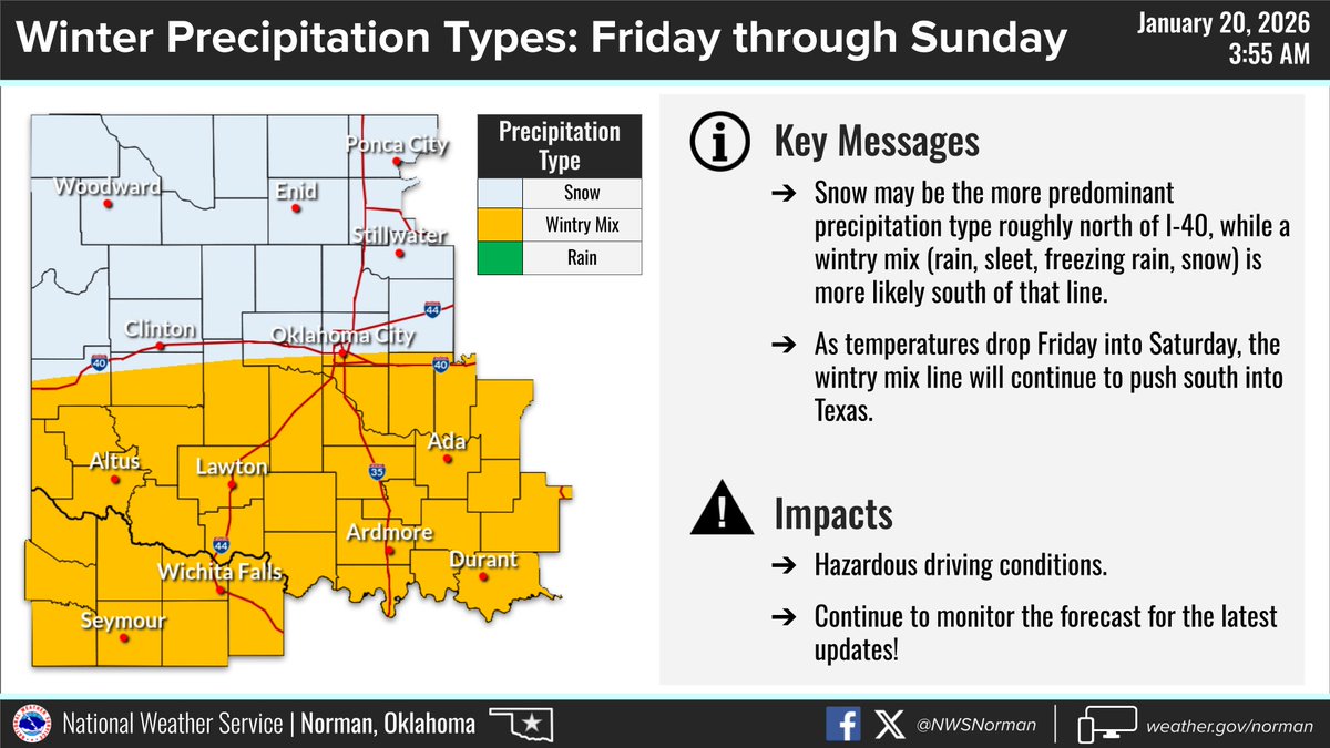
ALT Winter Precipitation: Below 32°F, snowflakes never melt. With sleet, droplets freeze and form ice before reaching the surface. Freezing rain is caused by rain, above 32°F in the sky, freezing on contact with the cold surface. If the surface temperature is above 32°F, rain will not freeze.
6
35
143
18,669
OKC Office of Emergency Management (OKC OEM) retweeted
A strong cold front Fri will bring cold arctic air to OK/TX through early next week. Breezy winds will make way for dangerously cold wind chills Sat through Mon morning. Some areas may not rise above freezing for at least 48 hours. Protect the 4 Ps! #txwx#okwx
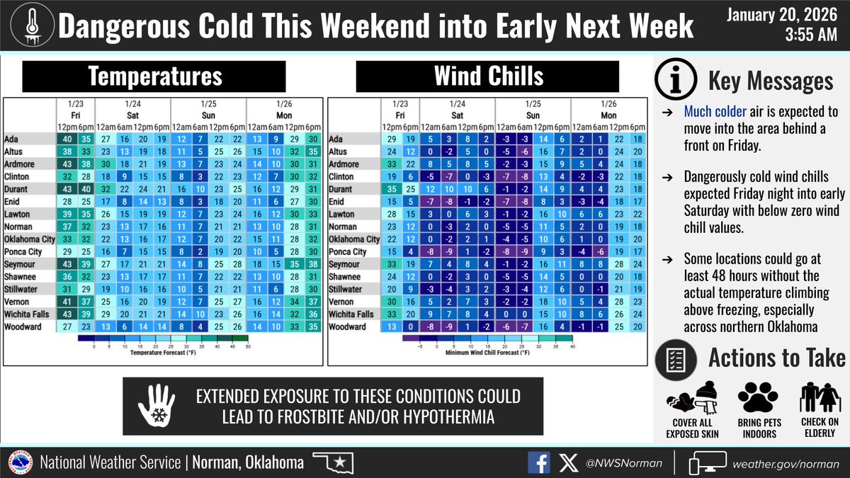
ALT This graphic shows the forecast temperatures and wind chills for Friday through Monday.
ALT Protect people, pets, pipes and plants from cold weather. People: 1) Minimize time outdoors. 2) Prepare for power outages. 3) Check on the elderly and other vulnerable people to make sure they're ok. Pets: 1) Keep your pets warm, dry and indoors as much as possible. 2) Ensure their food and water doesn't freeze. 3) Limit outside time and keep them bundled up. Pipes: 1) Insulate pipes if possible. 2) Open up sink cabinets to expose pipes to heated air. 3) Disconnect hoses & turn off water to sprinklers. Plants: 1) Know their temperature thresholds. 2) If possible, cover them before the cold weather sets in to help retain some heat.
1
14
42
7,705
OKC Office of Emergency Management (OKC OEM) retweeted
Chance for >1" of snow across the area is high (>70%). A corridor of higher probs for greater snow amounts may set up across central OK and may be subject to change with the evolution of the system. The highest chances for a glaze of ice will be across S OK and into western N TX.
1
17
97
13,429
OKC Office of Emergency Management (OKC OEM) retweeted
Continuing to see a potential for an impactful winter weather event Fri-Sun. The main takeaway is hazardous travel conditions are likely for portions of OK & N TX. Wintry mix will be possible Fri, especially S of I-40, before snow becomes the more likely precip type. #txwx#okwx