stochastic parrot
Joined November 2013
- Tweets 433
- Following 695
- Followers 159
- Likes 1,106
29 Photos and videos


Mar 30
Sneak peak of the next Applied Geospatial post: "Escape the permanent underclass by gambling on weather" (title still a work in progress). A look at weather prediction markets on @Kalshi and @Polymarket.
2
1
1
58
Mar 30
MRMS radar precip observations on the left, derived snow accumulation on the left
21
C. X. Ren retweeted

10 Sep 2025
in ep 1 of the new Earthsight podcast, @ren_christopher and i ramble about GeoAI, embeddings, land cover, NDVI, geospatial problem solving, and more.
apple: podcasts.apple.com/us/podcas…
spotify: creators.spotify.com/pod/pro…
youtube: youtu.be/nLJ-uxU8xFI
1
2
369
21 Jul 2025
Embeddings are all the rage in #geospatial right now, but what properties should we expect our #embeddings to have? I dug into the @GoogleDeepMind geospatial embeddings, and found that the training objectives used for the embedding model might be suboptimal (1/n)
1
91
21 Jul 2025
(2/n) In christopherren.substack.com/…, I show they appear to exihibit large scale spatial variations, correlating with elevation! This is an undesirable property since it is easy to filter/join on this if you have a digital elevation model.
1
63
21 Jul 2025
(3/n) Geospatial embeddings should compress what is hard to join later (texture, specific land-use, shape), not what is trivial (elevation, lat/long, other raster dataset).
58
C. X. Ren retweeted

21 Jul 2025
Yes.
Writing is not a second thing that happens after thinking. The act of writing is an act of thinking. Writing *is* thinking.
Students, academics, and anyone else who outsources their writing to LLMs will find their screens full of words and their minds emptied of thought.
526
6,600
29,816
2,593,719
19 Jul 2025
@Algomancer : you seem like the right person to ask about this: wanted ANN/HSNW index, need:
1. Reasonable build times/parallel index building.
2. On-disk.
3. Can sacrifice query latency for compression of the on-disk index.
Is there anything out there you've seen like that?
1
68
19 Jul 2025
Order of magnitude ~10-20M rows/ dims from 384-1024. Have tried @duckdb vss but hitting up against limits, no quantization support index needs to be held entirely in memory.
1
79
6 Jul 2025
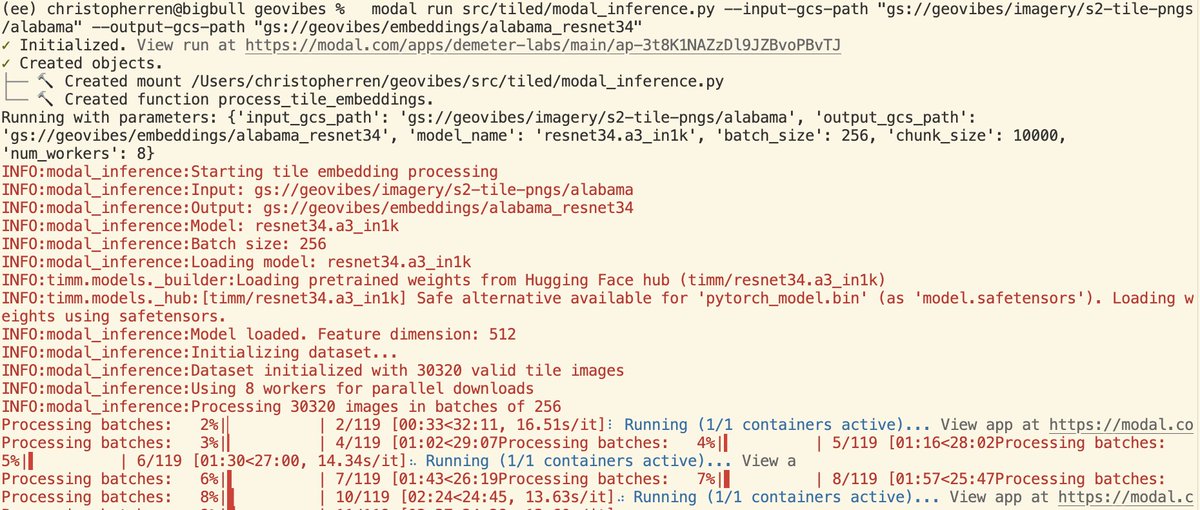
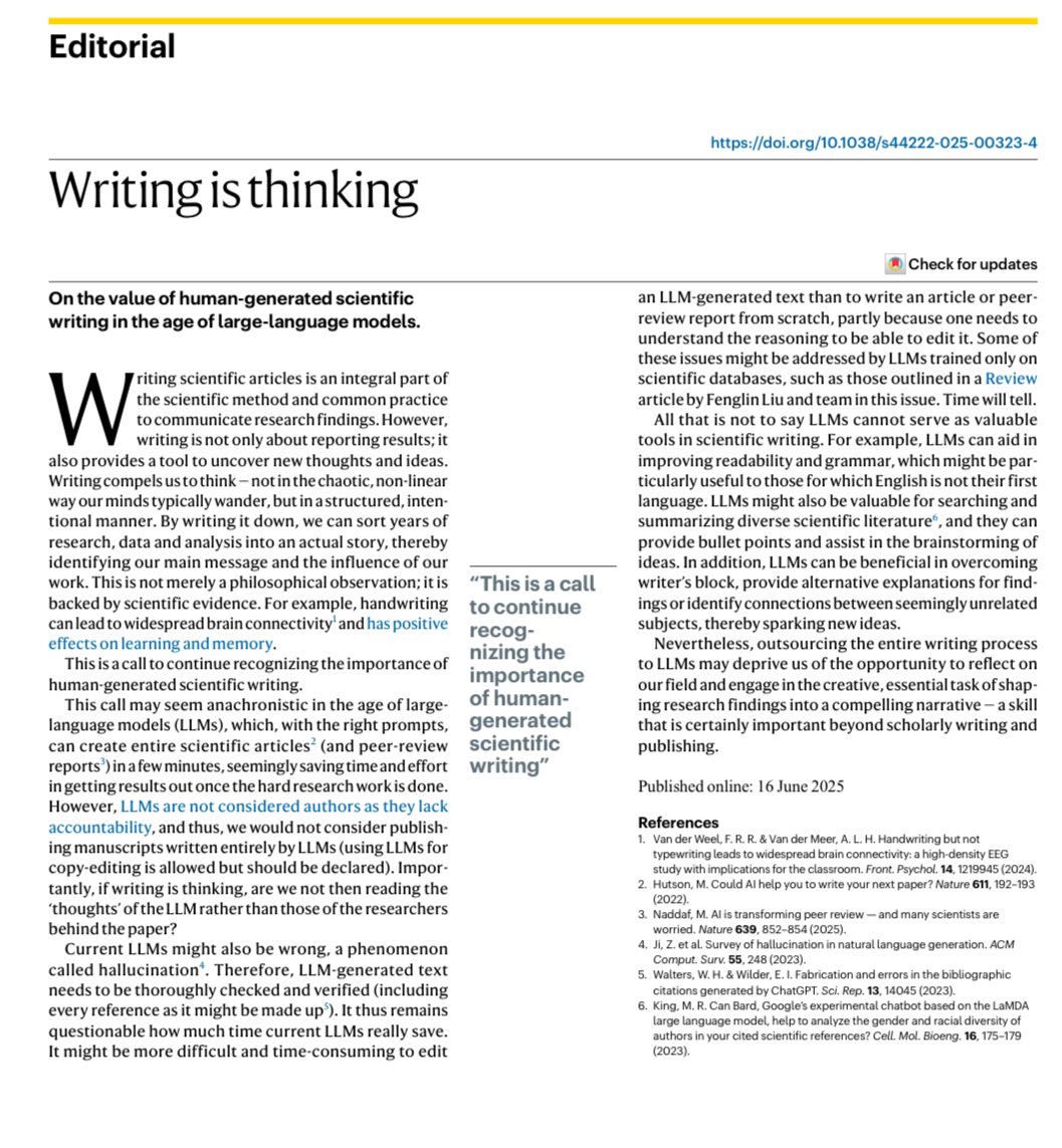
first impressions of @modal_labs , super easy to get started, slick interface, got me generating embeddings in no time. I should probably increase GPU utilization though.
115
C. X. Ren retweeted

24 Jun 2025
ever since I was a little boy I dreamed of configuring IAM polices for an enterprise AWS environment
85
607
6,964
282,773
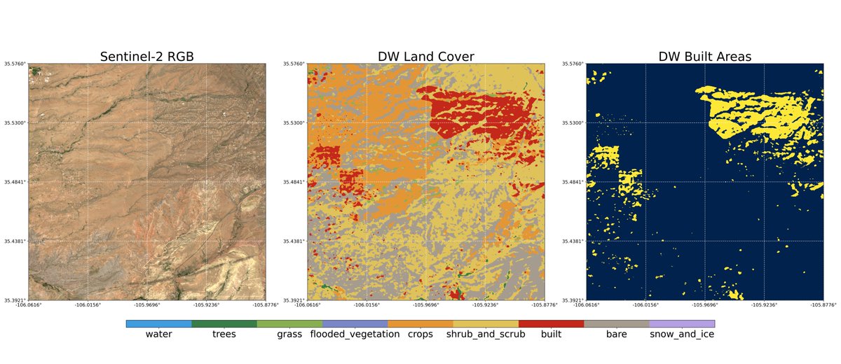
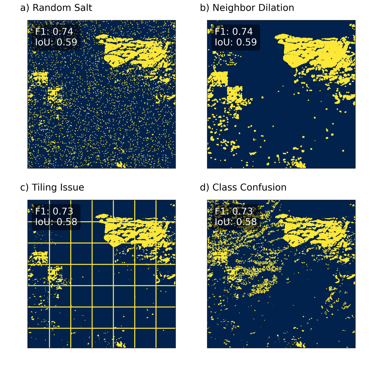
21 Jun 2025
The model is not the map: #geospatial ML models have diverse sources of error/failure modes. Instead of trusting benchmarks, we should make maps out of them and Look at the Data!
1
99
21 Jun 2025
In order to demonstrate this, I created the Santa Fe Quartet, an analogy to Anscombe's quartet
1
61
21 Jun 2025
I did this by pulling satellite derived land cover maps over Santa Fe and artificially introducing errors. The resulting maps all have the same f1 score for the built-area class. Read more about it here: christopherren.substack.com/…
58
19 Jun 2025
Probably nothing.
19 Jun 2025

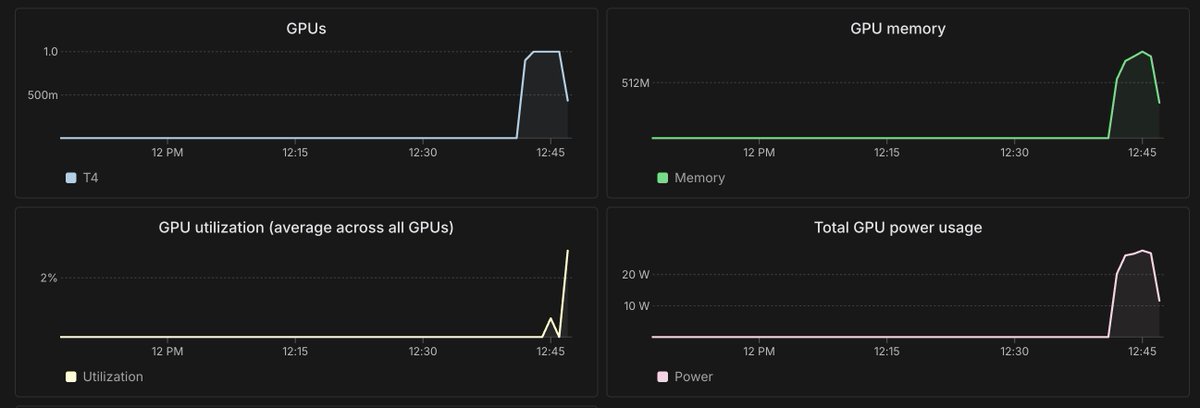
Most staple food crops are expected to experience substantial production losses due to climate change, even when mitigation measures to limit the impact of climate change are considered, according to a study in @Nature. go.nature.com/4lxo2zN
ALT This is figure 2, which shows projected end-of-century change in crop yields resulting from climate change, accounting for adaptation to climate and increasing incomes.
75
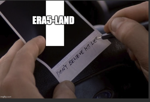
7 Jun 2025
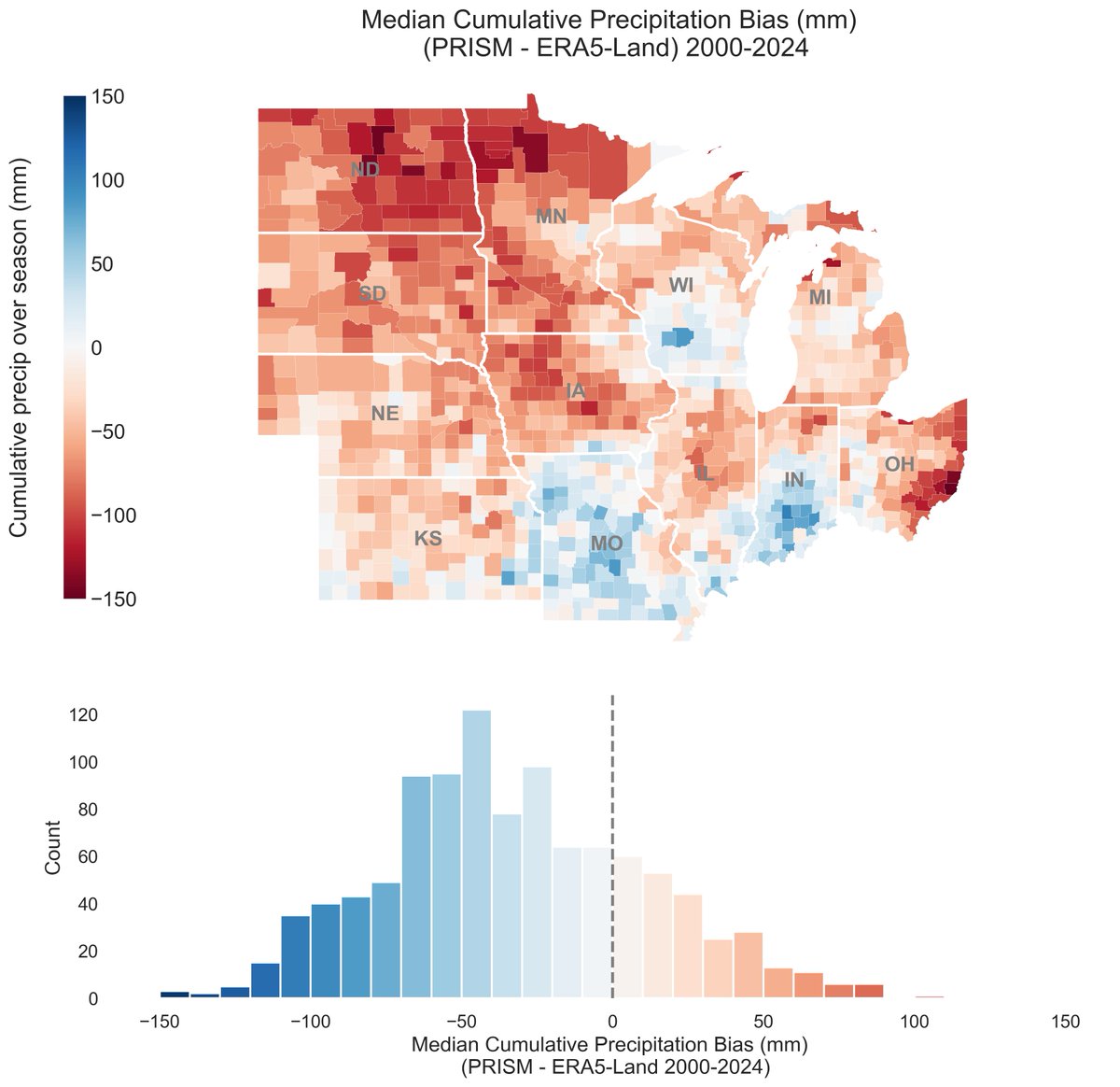
Sum precip over the growing season in the corn belt, aggregate it to the county level and compare (ERA5-Land and PRISM): you'll find huge, and I mean huge, differences in cumulative precipitation between 2000-2024. Showing the median bias over the 25 years here #geospatial
1
1
1
171