
@ZoneWatchWX CEO; Second by Second Lightning Detection & Severe Weather Intelligence
Joined June 2020
- Tweets 140
- Following 100
- Followers 472
- Likes 184
105 Photos and videos


Shore Fire near Calimesa in Badlands, California in Riverside County continues to burn and is spreading rapidly… It is currently 1,500 acres & 0% contained as of 9pm PT. Image courtesy by UCSD & AlertCA
2
3
431
Nice pop up storms behind the outflow boundary moving into the Phoenix area. Storms capable of frequent lightning, brief heavy rain, and gusty winds. #azwx #monsoon @ZoneWatchWX
1
4
233
Sina Moghaddami retweeted

Jun 15
Severe Thunderstorms surround the WHITE HOUSE UFC event right now! They are everywhere but there! President Trump's 250th American UFC event looks to have missed the danger. Talk about luck in DC tonight! Image taken 10PM EDT #UFC250 #UFCFreedom250 #UFCWhiteHouse

1
2
550

Jun 13
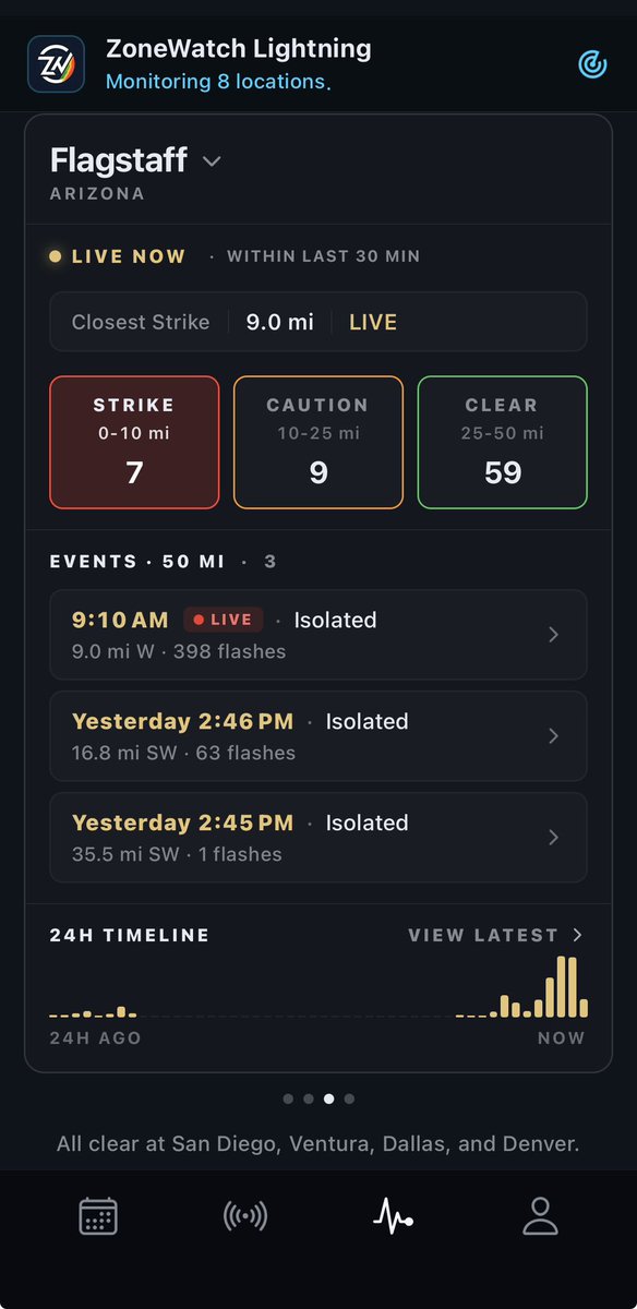
THE LIGHT SHOW IS STARTING FOR SOME
WOW Look at all the lightning strikes already across AZ and continuing to expand in activity! Coming straight from our proprietary lightning detection. Know when your in the Clear or in the STRIKE ZONE.
More storms are expected to continue popping off throughout the evening time.
1
1
4
116
Jun 10
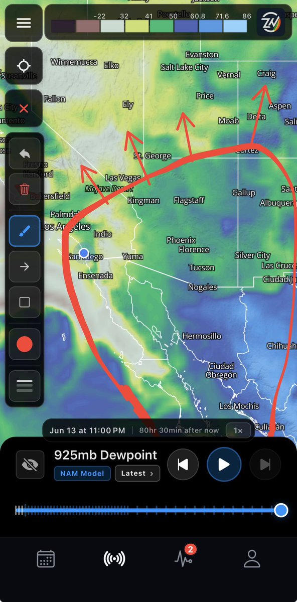
Tropical Moisture Expected to Flow Into the SouthWest
Update (Wed, 2:30 PM PT): Deep low to mid-level moisture is expected to move into the Southwest specifically Arizona and Southern California this coming weekend.
Based on precipitable water data from ZoneWatch and other sources, this will bring a risk of thunderstorms, especially across Arizona's higher terrain. The further south you are in the region, the higher the chance for showers and storms.
Stay tuned for a more detailed forecast coming tomorrow on ZoneWatch the app. Brief summary will also be on social media.
Next graphic will be more in depth for t-storm risk, timing, risk coverage and more.
2
2
99
Sina Moghaddami retweeted
Jun 5
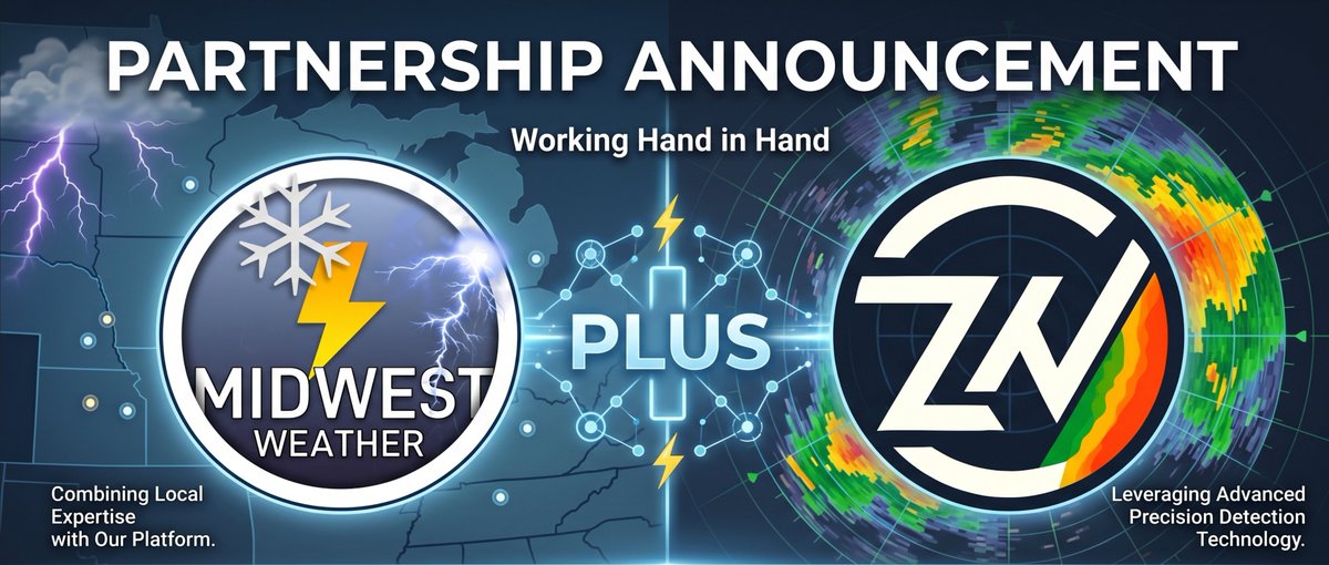
BIG ANNOUNCEMENT!
We are absolutely thrilled to announce our official partnership with @MidwestWeathe_r (MIDWEST WEATHER)
Together, we’re taking weather tracking to the next level. Through this collaboration, we’ll be expanding the reach of our proprietary lightning and precipitation detection technology, as well as giving more communities access to our comprehensive weather platform.
But it doesn't stop there. We are working hand-in-hand with the incredible team at Midwest Weather to transform how you receive your weather data. Together, we will:
- Deliver better, hyper-accurate forecasts tailored to your region.
- Bring you higher quality, real-time updates so you're never caught off guard.
- Enhance severe weather tracking to maximize safety and preparation times.
- Integrate cutting-edge data directly into the tools you rely on every day.
When it comes to extreme weather, every second counts. We can't wait to combine our tech with Midwest Weather's local expertise to keep you safer and more informed than ever before.
Stay tuned for further updates.
1
6
135
Jun 4
I'm not even sure where to start, but expect a lot of posts today given that there is so much to update you on…
First things first, we will be going over the El Niño situation, followed by many, many other topics that I know you guys are dying for me to talk about… confirmed via DMs…
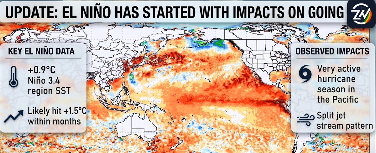
Current Update on El Niño:
We are already transitioning from a neutral phase into the starting phases of El Niño.
The Niño 3.4 region, which is how we measure sea surface temperatures (SST), has already reached 0.9°C. It is continuing to rise and will likely hit 1.5°C within months. Weather patterns are already starting to show changes, and they will continue to shift rapidly as these temperatures continue to rise…
Impacts can already be seen:
🌀 A very active hurricane season across the Pacific.
🌬️ A split jet stream, with the southern branch currently dipping into our area and the northern branch staying further north.
We will continue to monitor further impacts. As bigger updates come out WITHOUT THE HYPE I will be sure to share them with you all…
1
4
19
678
May 31
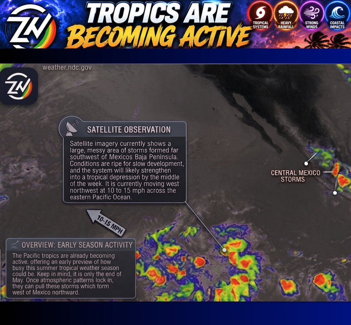
🌀 TROPICS ARE BECOMING ACTIVE 🌀
The Pacific tropics are waking up early, a clear sign of how busy this summer could get. Keep in mind it is only the end of May.
Once steering patterns lock in, they can pull these storms that form west of Mexico northward. These are major moisture producers that we will watch closely for impacts like gusty winds, heavy rain, and lightning.
🛰️ On the Satellite:
A large messy area of storms has formed far southwest of Mexicos Baja Peninsula. Conditions are ripe for slow growth, and it will likely strengthen into a tropical depression by midweek. It is currently moving west northwest at 10 to 15 mph across the eastern Pacific.
2
2
7
383
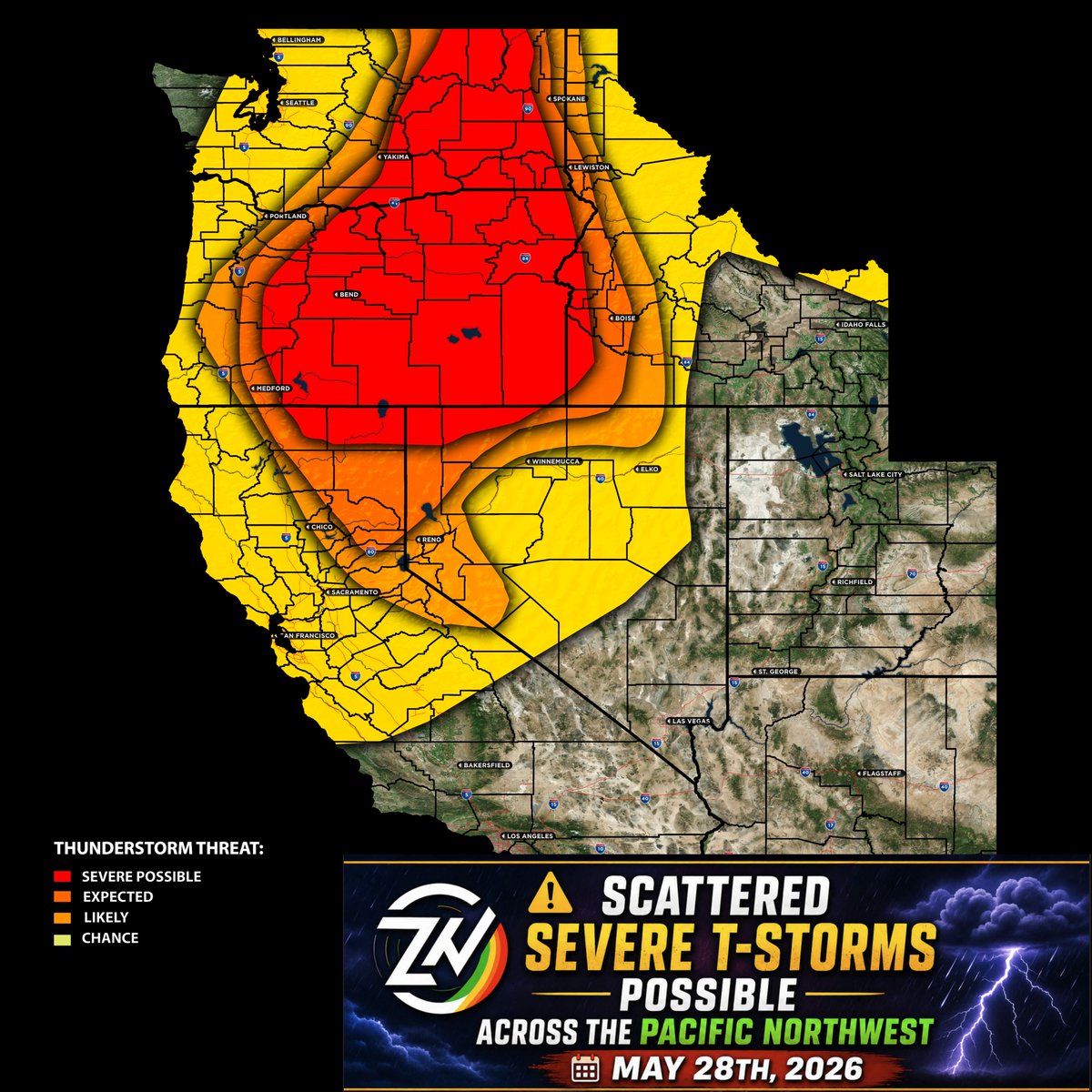
May 28
Scattered Severe T-Storms Possible Across the Pacific Northwest on May 28th, 2026
Damaging winds large hail and isolated tornadoes are possible this afternoon through early evening across northeastern Oregon southeastern Washington and western Idaho
Track the storms, lightning and get real time updates directly on the zonewatch app now
3
10
536
Sina Moghaddami retweeted
May 27
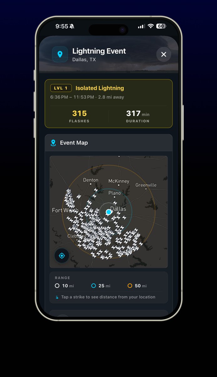
Dallas seriously getting hard with widespread lightning activity. Track it now on the ZoneWatch app second by second.
2
2
124
May 26
AZ is already seeing pre-monsoon storms, hinting at a wild season ahead! ⛈️
Forget the "super El Niño" hype the real action starts in August. Record Pacific water heat near CA means massive moisture, instability, and heavy rain to work with... this is especially with tropical activity as we go into the summer period. Regardless, an active pattern coming up.
Read more here: facebook.com/sinamoghaddamio…
3
8
470
Sina Moghaddami retweeted
May 11
⚡ 2.58k lightning strikes in just 5 minutes (over 500 strikes per minute!).
Tracking this intense line of storms pushing through southeast Texas with absolute precision. Watch every single strike plot second-by-second, live as it happens. Don't settle for delayed updates get real-time lightning detection, only on ZoneWatch.
Check it out at zonewatchpro.com
1
2
152
Sina Moghaddami retweeted
Apr 20
Introducing ZoneWatch 3.0
Near-3D NEXRAD radar, 2D/3D fusion modeling, and live lightning strikes that update in SECONDS. ⚡️
Stop reacting. Start predicting.
Lock in the yearly deal ($5.56/mo) now: 👉 zonewatchpro.com/download?pr…
2
2
36
969,170
Apr 17
ZoneWatch is leveling up. Starting this Saturday, we’re rolling out a new UI and features in phases. Stay tuned for the ultimate resource for individuals and businesses we’re ready to shake up the competition!
Web browser first, app later on…
3
69
Apr 16
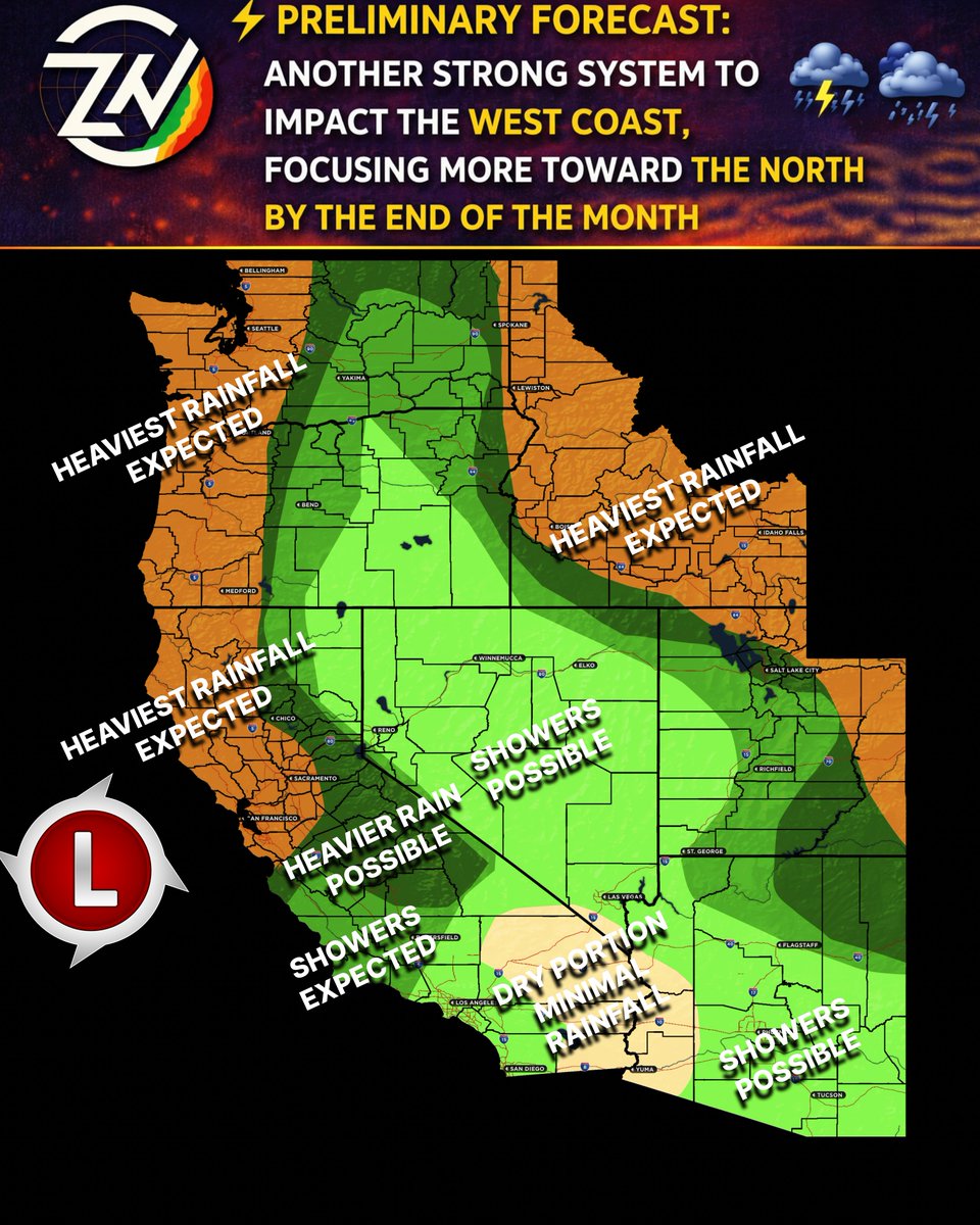
⚠️ LATE-APRIL WEST COAST STORM PREVIEW ⚠️
A powerful low-pressure system is targeting the West Coast toward the end of the month, with the most intense impacts focused decisively up North!
Impacts Expected:
☔ Extreme Rain: Flooding threat for NorCal, OR, WA & ID.
⛈️ Severe Convection: Risk of severe storms along the NorCal/OR coast. Track specific rates on the ZoneWatch app!
🏔️ Mountain Snow: Blizzard conditions possible across the Cascades, Sierras & Northern Rockies.
🏜️ SoCal Dry Slot: Mostly dry and missing the heavy stuff (subject to change if the track shifts south).
⚡ Southwest Instability: Watching a scattered T-Storm setup for AZ/NM around April 27th!
🚗 Travel: Major disruptions across CA (NorCal/Central), WA, OR, ID, NV & UT.
Timing: This is a multi-day event peaking in the final week of the month as the system pushes east.
Part of other regions? Wait for your update or check ZoneWatch.
Download for FREE… want to get everything we offer? LIMITED 15% off Premium to track the threats in your specific zone and much more: zonewatchpro.com/download?re…
1
87
Apr 15
Coming soon to ZoneWatch web, followed by the app in the coming weeks: NEXRAD Level II Super-Res Site Selection Radar. Stay tuned for updates.
1
3
205
Apr 14
Isolated T-storms recently impacted the mountains of LA and San Bernardino, the High Deserts, and surrounding regions (Already mentioned on SCWF).
ZoneWatch Lightning was on the job, tracking every strike with real-time mapping and CG/CC classification. Stay tuned as we're preparing to launch a sophisticated, proprietary lightning prediction model to give ZoneWatch users an even greater edge without future technology.
These storms are expected to diminish this evening and lingering moisture is expected to move out by tonight.
Download for FREE… want to get everything we offer? LMITED 15% off Premium to track lightning, rain, pattern changes & much more!: zonewatchpro.com/download?re…
4
128
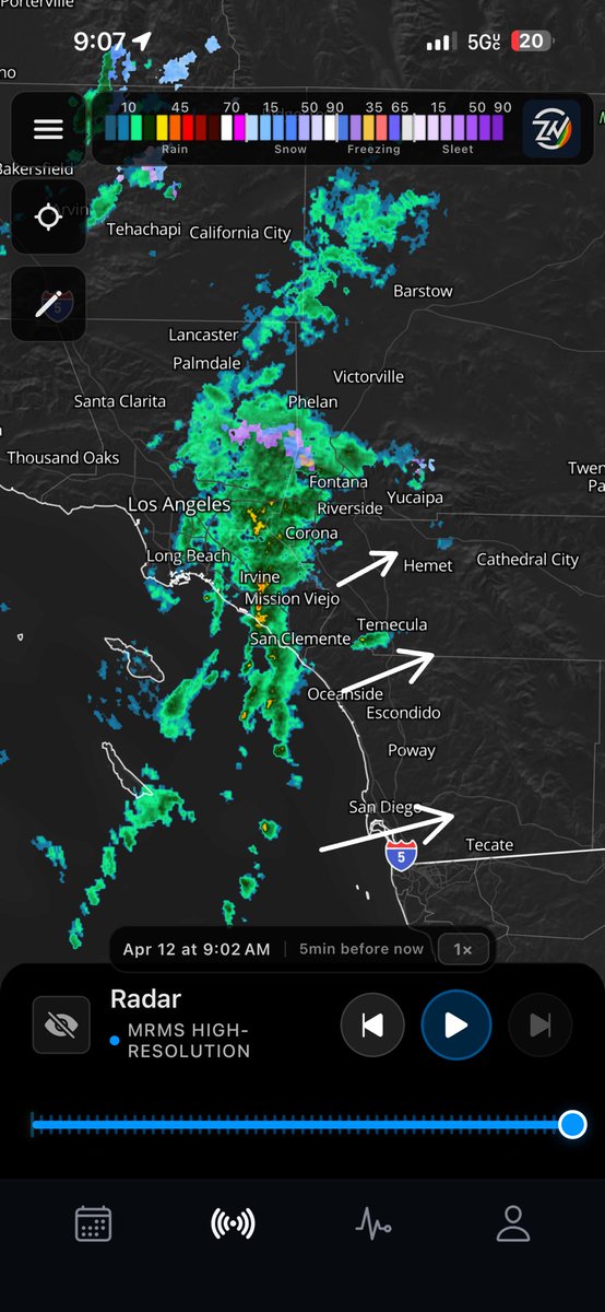
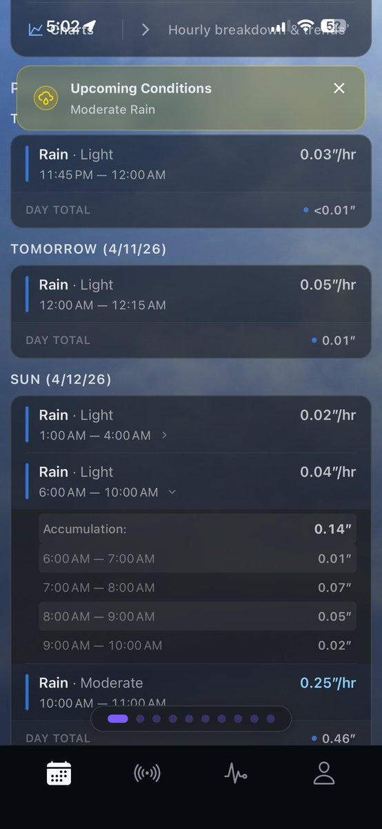
Apr 12
Update as of 9:11am PT: here is the current radar from ZoneWatch… rain showers as stated with nothing severe or overhyped… a few heavier showers embedded with a couple of areas getting windy conditions as well.
Arizona and surrounding areas, your update comes next.
1
3
51
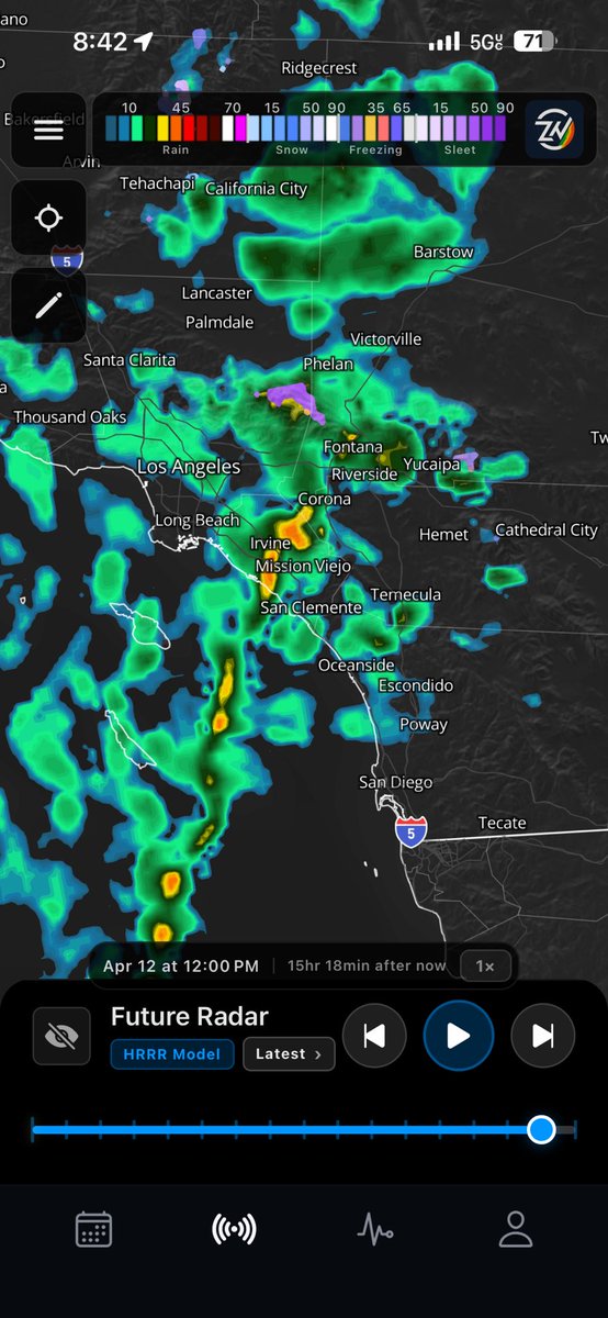
Apr 12
Other sources seriously need to stop overhyping this event for SoCal on Sunday morning. Heavy showers, wind, and cooler weather? Yes. A possible embedded t-storm? Also yes. Severe storms with major impacts similar to NorCal? Not even close…
ZoneWatch already reporting on it and our ZWCast is updating any heavy cells hours before impact only alerting you if it’s necessary…
4
67
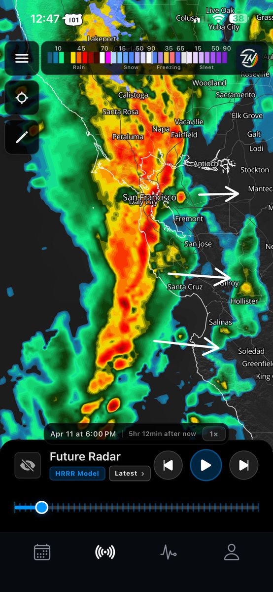
Apr 11
⚠️ STRONG BAND OF STORMS EXPECTED TO SLAM THE BAY AREA TONIGHT
Summary: A powerful line of heavy rain and intense storms will push onshore later today, taking direct aim at the Bay Area down through the Central Coast.
Impact: Expect torrential downpours, localized roadway flooding, and very dangerous driving conditions for the evening commute. Convective storms could also bring frequent lightning as well.
⏰ Timing:
Storms to slam the coast and move inland right around 6:00 PM PT tonight.
Track the exact timing for your city on the ZoneWatch app! Image from future radar HRRR.
1
4
216