
Become a member of the Chaser Academy & unlock Bonus Videos, Live Group Coaching, & Unlimited Q&A! youtube.com/channel/UCCP12NY…
Joined March 2025
- Tweets 9,362
- Following 32
- Followers 2,873
- Likes 8,901
2,272 Photos and videos


Pinned Tweet

Click the link in our bio and join the FREE Discord community!
Learn how to recognize a low precipitation supercell by its iconic barber pole updraft, understand its unique radar signature, and know what hail and tornado hazards to watch for despite its deceptively calm appearance.
#stormchasing #stormchaser #stormchasers #weather #tornado
1
5
1,073
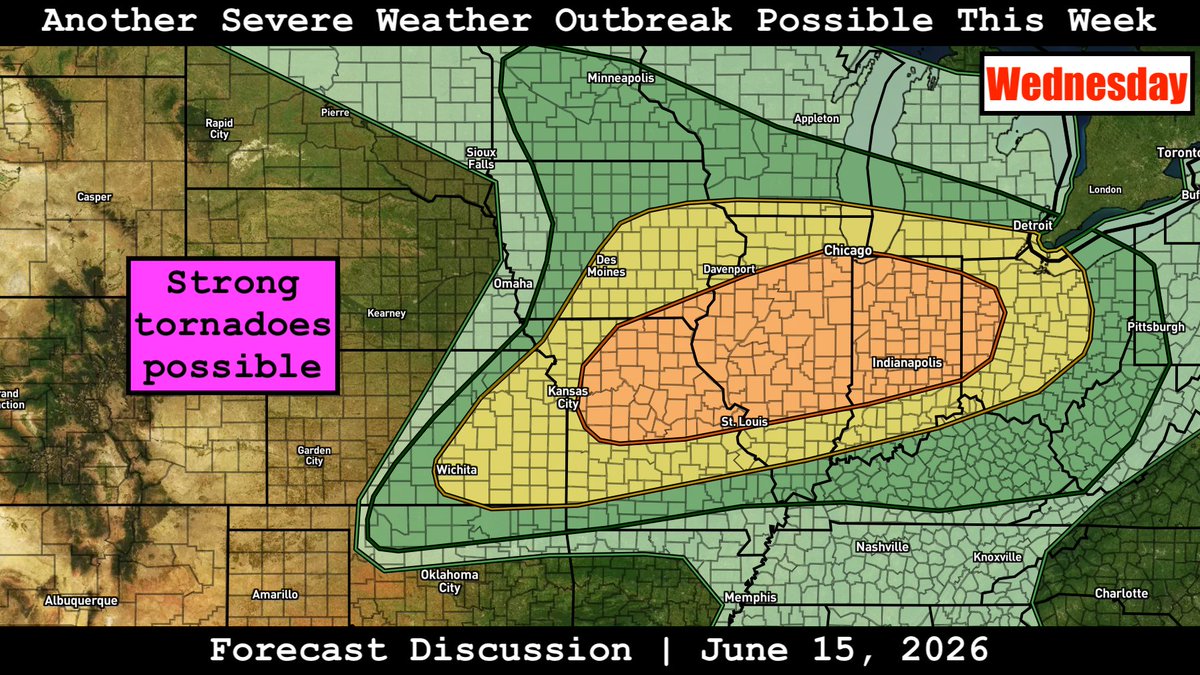
How many of you will be going out for Wednesday's severe risk in the midwest? 👀
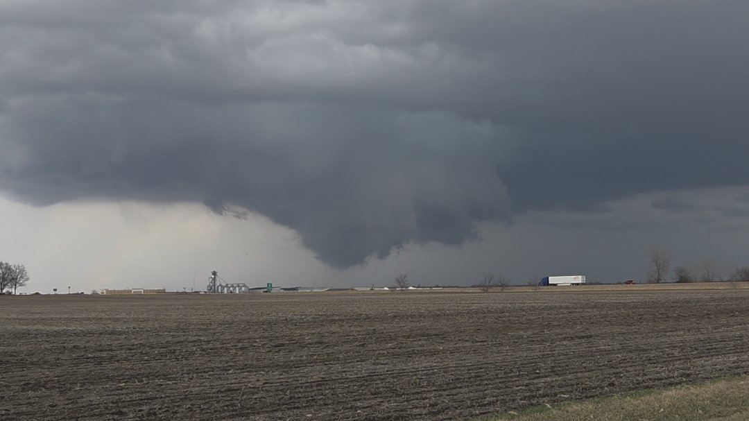
Photo credit: @Annuh_wx (Pontiac Illinois, 3/10/2026)
1
1
2
142
🎙️ Forecast Brief
🎯 THE SETUP
A compact mid-level shortwave trough will swing east through the Great Lakes on Tuesday, June 16, 2026, bringing scattered showers and thunderstorms to the Midwest. The early 0600Z outlook issued a marginal risk for the Midwest/Lower Michigan, but confidence in SEVERE POTENTIAL remained limited by lackluster boundary layer moisture—surface dewpoints only MID/UPPER 50S TO NEAR 60°F. The 1730Z update maintained the marginal risk across a broader swath from the northern Plains into the Upper Midwest and Great Lakes to the Central Plains, with the key message unchanged: STEEP LAPSE RATES AND STRONG SHEAR, but MOISTURE REMAINS THE LIMITING FACTOR. A weak cold front will push through the region during the afternoon/evening, serving as the primary focus for convective development.
━━━━━━━━━━
🗣️ KEY POINTS
⚡ MARGINAL (LEVEL 1/5) SEVERE RISK across portions of the Midwest into Lower Michigan Tuesday afternoon/evening—SCATTERED STRONG TO SEVERE STORMS possible
💨 MAIN THREAT: STRONG/DAMAGING WIND GUSTS AND ISOLATED LARGE HAIL; a few TORNADO SPIN-UPS cannot be ruled out given 100-200 m²/s² helicity values
🌡️ CRITICAL LIMITATION: MEAGER BOUNDARY LAYER MOISTURE—dewpoints only MID/UPPER 50S TO LOW 60S°F, capping overall severe potential
📍 CORE TARGET ZONE (TIER 1): NORTHERN INDIANA, SOUTHERN/LOWER MICHIGAN, NORTHWEST OHIO—best overlap of moisture, shear, and forcing along the afternoon cold front
🕐 PRIME TIMING: AFTERNOON INTO EARLY EVENING (ROUGHLY 18-00Z / 1-7 PM LOCAL) as the front moves through and diurnal heating peaks
🎯 CHASE POTENTIAL: LOW TO MODERATE—brief/transient supercells and clusters possible, but LIMITED MOISTURE AND INSTABILITY mean storms will struggle; NOT A HIGH-CONFIDENCE SETUP
⚠️ WEDNESDAY LOOMS MUCH LARGER—Enhanced (Level 3/5) risk developing for the same region with far better moisture, shear, and instability; SAVE YOUR ENERGY
━━━━━━━━━━
🌪️ CHASE POTENTIAL
🎯 CORE TARGET (TIER 1): NORTHERN INDIANA, SOUTHERN/LOWER MICHIGAN, NORTHWEST OHIO
- STORM MODE: Transient supercells and multicell clusters along and ahead of the weak cold front
- TIMING: 18-00Z (1-7 PM LOCAL), peaking mid-to-late afternoon as heating maximizes and front approaches
- ENVIRONMENT: Bulk shear ~35 KTS, lapse rates 7-8°C/KM, MLCAPE UP TO 1500 J/KG, SRH 100-200 M²/S²—sufficient for ROTATING UPDRAFTS and BRIEF ORGANIZED STRUCTURES
- THREATS: ISOLATED LARGE HAIL and STRONG/DAMAGING WIND GUSTS primary; BRIEF TORNADOES possible but not favored
- KEY UNCERTAINTY: MOISTURE RETURN—dewpoints starting UPPER 40S, rising only to MID/UPPER 50S by afternoon; CLOUD COVER from early convection may further limit instability
- CHASE VERDICT: LOW-TO-MODERATE CONFIDENCE—storms will be SCATTERED AND BRIEF, with the BEST ACTIVITY EAST OF I-39/I-65 where moisture slightly better; NOT A CHASE-FROM-HOME DAY unless already positioned
🌀 SECONDARY ZONE (TIER 2): NORTHERN IOWA/SOUTHERN WISCONSIN—OVERNIGHT
- STORM MODE: Elevated/isentropic convection along frontal zone late Tuesday night (near 12Z/7 AM Wednesday)
- ENVIRONMENT: Richer 850MB MOISTURE, 1500-2000 J/KG MUCAPE, strong shear beneath 100 KT 300MB JET, but ELEVATED INSTABILITY only
- THREATS: ISOLATED SEVERE WIND/HAIL possible; primarily a NOCTURNAL EVENT with low chase appeal
⚠️ BOTTOM LINE: Tuesday is a MARGINAL, MOISTURE-STARVED SETUP with BRIEF/TRANSIENT SEVERE POTENTIAL. The REAL SHOW IS WEDNESDAY—an Enhanced (Level 3/5) risk with far superior moisture, instability, and shear across much of the same region. CONSIDER TUESDAY A POSITIONING DAY and conserve resources for the more robust mid-week system.
━━━━━━━━━━
🧭 WHAT THE LOCAL OFFICES ARE SAYING
TIER 1 CORE (IWX/GRR/CLE/ILN): All four offices emphasize MARGINAL SEVERE RISK TUESDAY WITH DAMAGING WINDS/HAIL PRIMARY, but stress MOISTURE AS THE LIMITING FACTOR (dewpoints mid/upper 50s). IWX notes SHEAR/HELICITY SUFFICIENT FOR TORNADO SPIN-UPS; GRR highlights FIRST LINE LIKELY SUB-SEVERE, with BETTER SEVERE CHANCES EARLY EVENING as mid-level trough arrives; CLE/ILN both flag WEDNESDAY AS THE FAR LARGER CONCERN with Enhanced/Slight risks and all modes of severe weather possible.
TIER 2/3 OFFICES (LOT, IND, ILX, LSX, SGF, TOP, ICT, RNK, LWX, PBZ, AKQ, OAX, FSD, ABR, MPX, ARX) broadly echo the marginal threat at lower confidence, with most attention already shifted to Wednesday's more robust system; northern Plains offices (FSD/ABR/MPX) note Tuesday night elevated/isentropic activity along frontal zone, but severe potential remains conditional.
━━━━━━━━━━
👀 AREAS TO WATCH
🔍 NORTHERN OKLAHOMA: Conditional—some guidance hints at LATE AFTERNOON/EARLY EVENING STORMS in warm advection regime, but NO CLEAR INITIATION FOCUS beyond daytime heating; CONFIDENCE LOW. If storms develop, STRONG GUSTS AND ISOLATED HAIL possible; SPC may add low probabilities in later updates.
🔍 NORTHERN IOWA VICINITY—LATE NIGHT: ELEVATED CONVECTION with richer 850mb moisture and 1500-2000 J/KG MUCAPE possible near 12Z Wednesday; NOCTURNAL TIMING and elevated nature limit chase appeal, but bears monitoring if you're positioning overnight.
━━━━━━━━━━
✅ End of brief.
1
1
2
290
Storm Chaser Coaching retweeted

LINK: youtube.com/watch?v=ZG3sOa9f…
Initial forecast discussion on yet another severe weather outbreak set to take aim at the Midwest on Wednesday (June 17). As of now, all hazards appear possible, including strong tornadoes, with the threat shifting east on Thursday. In this video, we'll take a look at current data and compare/contrast current model output to come up with a range of possible outcomes for this event.
6
12
75
5,714
Storm Chaser Coaching retweeted

Wednesday has tornado outbreak written all over it
21
19
473
77,631
Storm Chaser Coaching retweeted
🎙️ LIVE Group Coaching session for @TornadoCoaching tonight at 8 ET!
I’ll be running a Forecast Challenge and answering all of your questions. 💬
This event is for Chaser Academy members.
👉 Become a member here: youtube.com/channel/UCCP12NY…
👉 Join Discord here: discord.gg/stormchasercoachi…

2
11
1,525
🌩️ Forecasting from your phone is great.
Forecasting from your desktop is even better.
WeatherFront is now available on desktop, making it easier than ever to analyze weather and track severe storms.
Check out @WxFront now!
👉 buff.ly/fs8n01H
146
🌩️ Where would YOU target?
Tonight at 8 ET, @convchronicles is running an interactive Forecast Challenge where you'll analyze a severe weather setup, pick your target, and compare your reasoning with the group.
👉 Join Discord here: buff.ly/n849IdQ
3
182
Click the link in our bio and join the FREE Discord community!
By watching this video, you'll learn the key differences between slow and fast-moving outflow boundaries and why boundary speed is critical to determining whether storms can produce tornadoes or become elevated and non-tornadic.
#stormchasing #stormchaser #stormchasers #weather #tornado
173
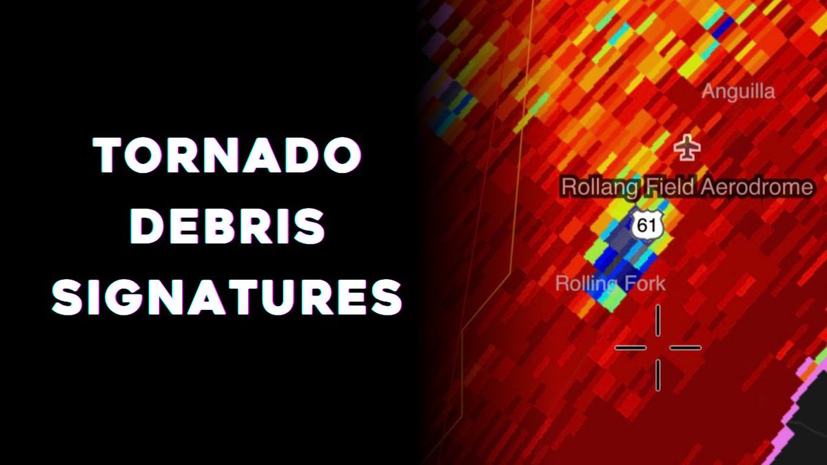
📡 Not every tight velocity couplet means a tornado is occurring.
A true Tornado Debris Signature requires BOTH:
🌪️ A TVS
🗑️ A debris signature
If they aren't colocated, be skeptical.
🎥 Watch for FREE: buff.ly/cF6L51n
1
179
🚙 Long chases require comfy clothes. Luckily, we’ve got that part covered.
🛒 Shop SCC merch now: buff.ly/8cLty8q
1
163
📊 LIVE Group Coaching tonight at 8 ET with @convchronicles
Think you've got what it takes to forecast severe weather?
Put your skills to the test during tonight's Forecast Challenge!
👉 Join Discord here: buff.ly/n849IdQ
1
156
Chasing isn't just about getting the best footage—
It's about getting home.
📗 Download our FREE ebook Eight Rules for Storm Chasing Safely today.
👉 buff.ly/EMkuozO
1
143
1
3
26
748
⚠️ Friendly reminder:
Everything in our merch store is currently 20% off.
Get your savings while they last 👇
🛒 Shop now: buff.ly/PyPSgMS
154
📡 What's a forecasting skill you're currently trying to improve?
6
1
12
894
📋 Forecast Verification
# FORECAST VERIFICATION BRIEF: Sunday, June 14, 2026
🌪️ GROUND TRUTH
WHAT ACTUALLY HAPPENED:
⛈️ WIDESPREAD SEVERE WEATHER OUTBREAK across the UPPER OHIO VALLEY, MID-ATLANTIC, AND NORTHEAST from mid-afternoon through late evening. The event unfolded in TWO DISTINCT WAVES: an earlier cluster across OHIO/WESTERN PENNSYLVANIA/GREAT LAKES (1600-2100 UTC), followed by a MORE INTENSE CORRIDOR across the MID-ATLANTIC (eastern PA/MD/VA/NC, 2200-0300 UTC).
🌪️ TORNADO REPORTS: 5 CONFIRMED
- WESTERN PA CLUSTER: 3 tornadoes in JEFFERSON COUNTY PA (2022-2041 UTC), including a confirmed tornado near Worthville and tree damage on SR-301
- OHIO: 2 tornadoes in COLUMBIANA COUNTY OH (2100-2117 UTC)
- All tornadoes concentrated in the UPPER OHIO VALLEY CORRIDOR during the earlier wave
💨 WIND REPORTS: 10 DAMAGING WIND EVENTS
- GREAT LAKES/OHIO: 61 mph gust at Clay Center OH (1730 UTC), 59 mph near Sandusky (1814 UTC), widespread tree/power line damage across ERIE/SANDUSKY/OTTAWA COUNTIES
- SOUTHEAST EARLY: isolated wind damage in PICKENS SC/FRANKLIN GA (1635-1726 UTC)
- Activity concentrated 1630-1900 UTC across the northern tier
🧊 HAIL REPORTS: 9 EVENTS
- Largest: 1.75" (GOLF BALL) IN NASH COUNTY NC (2321 UTC) and 1.25" IN CRAWFORD PA (2041 UTC), HAMPTON VA (2251 UTC), RIPLEY MD (2320 UTC)
- HEAVILY CONCENTRATED IN THE MID-ATLANTIC EVENING WAVE (2041-2324 UTC)
- Late timing confirms the SECOND, MORE ORGANIZED CORRIDOR was the primary severe producer
📡 WARNING ACTIVITY: 135 WARNINGS (17 tornado, 118 severe thunderstorm) across 14 offices
- BUSIEST OFFICES: CTP (30), AKQ (18), CLE (18), PBZ (18), LWX (13) — the MID-ATLANTIC CORE (CTP/AKQ/LWX = 61 warnings) and UPPER OHIO VALLEY (CLE/PBZ = 36 warnings) dominated
- TORNADO WARNINGS: concentrated in WESTERN PA and OHIO during the 2000-2200 UTC window
- Warning window: 1628 UTC → 0316 UTC — a 10 HOUR SEVERE WEATHER EVENT
━━━━━━━━━━
🎯 BOTTOM LINE
OVERALL PERFORMANCE: STRONG OPERATIONAL FORECAST WITH EXCELLENT REGIONAL TARGETING, THOUGH MAGNITUDE UNDERESTIMATED FOR THE MID-ATLANTIC CORRIDOR.
BIGGEST HITS:
✅ GEOGRAPHY: Day 1 and Day 2 both nailed the MID-ATLANTIC/UPPER OHIO VALLEY as the primary threat zones — the Slight Risk placement verified exceptionally well
✅ TIMING: Afternoon-evening window (1600-0300 UTC) verified perfectly; both outlooks correctly identified the PROGRESSIVE NATURE of the event
✅ PRIMARY HAZARD: DAMAGING WINDS were correctly forecast as the main threat and dominated the verified reports
✅ TORNADO THREAT RECOGNITION: Day 1 correctly highlighted EMBEDDED TORNADO POTENTIAL in the Upper Ohio Valley with stronger wind profiles — all 5 tornadoes occurred there
BIGGEST MISSES:
❌ MAGNITUDE UNDERESTIMATION: The MID-ATLANTIC CORRIDOR (especially EASTERN PA/MD/VA/NC) produced a MUCH MORE SIGNIFICANT EVENT than Day 2 anticipated — SPC collaboration notes mentioned "possible upgrade to Enhanced" but it remained Slight Risk
❌ PROBABILITY CALIBRATION: The 30% WIND PROBABILITIES for DelMarVa/SE PA/S NJ were justified, but the CONCENTRATION AND DURATION of the Mid-Atlantic event (61 warnings from CTP/AKQ/LWX alone) suggested ENHANCED RISK territory
❌ HAIL UNDERPLAY: While mentioned as "isolated," 9 HAIL REPORTS including GOLF BALL HAIL IN NC showed a MORE ROBUST HAIL ENVIRONMENT than anticipated, especially in the evening Mid-Atlantic wave
KEY TAKEAWAYS:
🔥 TWO-WAVE STRUCTURE: The event split into an EARLY OHIO VALLEY TORNADO/WIND PHASE (1600-2100 UTC) and a LATER, MORE INTENSE MID-ATLANTIC SEVERE WIND/HAIL PHASE (2200-0300 UTC) — Day 1 better captured this evolution
🎯 ENHANCED VS. SLIGHT DEBATE: Day 2's collaboration notes about a POSSIBLE ENHANCED UPGRADE were prescient — the WARNING DENSITY, DURATION, AND REPORT CONCENTRATION across the Mid-Atlantic core supported that level, especially given the 1500-2500 J/KG MLCAPE and organized clusters
📍 TORNADO PLACEMENT: The WESTERN PA TORNADO CLUSTER verified the Day 1 emphasis on STRONGER WIND PROFILES/EFFECTIVE SHEAR in the Upper Ohio Valley — tornadoes stayed north of the higher instability but weaker shear zone
⚡ DCAPE/INVERTED-V: Local AFDs (RNK, AKQ) emphasized DCAPE 1000-1300 J/KG and DRY MID-LEVEL AIR — the verified DAMAGING WIND DOMINANCE and WATER-LOADED DOWNBURSTS (FFC noted 45 mph at their office) confirmed this as the PRIMARY MECHANISM
🌧️ MOISTURE GRADIENT: The NORTHWARD EXTENT OF MOISTURE (Day 2 uncertainty: "low 60s F dewpoints into PA/NY") ended up MORE ROBUST THAN EXPECTED, fueling the PROLONGED MID-ATLANTIC EVENT into the evening hours
━━━━━━━━━━
🗺️ SPC VERIFICATION
DAY 2 OUTLOOK (ISSUED 0015 UTC JUN 13) VS. DAY 1 OUTLOOK (ISSUED 1254 UTC JUN 14) VS. REALITY:
📍 GEOGRAPHY:
- DAY 2: Slight Risk across UPPER OHIO VALLEY TO MID-ATLANTIC — broadly correct but LESS SPECIFIC
- DAY 1: Refined Slight Risk with BETTER FOCUS on the NORTHEAST/APPALACHIANS/MID-ATLANTIC corridor — closer to verified activity
- REALITY: The MID-ATLANTIC CORRIDOR (eastern PA through VA/NC) was the BULLSEYE, with a secondary UPPER OHIO VALLEY tornado zone — Day 1's refinement was SPOT-ON
⚡ SEVERE THREAT MAGNITUDE:
- DAY 2: Acknowledged 30% WIND PROBABILITIES for DelMarVa/SE PA/S NJ and noted "HIGHER COVERAGE PROBABILITIES/UPGRADE TO ENHANCED COULD BE NEEDED" — this was PRESCIENT BUT NOT ACTED UPON
- DAY 1: Maintained Slight Risk but described "SEVERAL ORGANIZED CLUSTERS CAPABLE OF SCATTERED DAMAGING WIND GUSTS" and "LOCALLY HIGHER CONCENTRATIONS OF WIND DAMAGE" — language suggested HIGHER-END SLIGHT
- REALITY: The 135 WARNINGS, 10 WIND REPORTS, 9 HAIL REPORTS, AND 10 HOUR DURATION across the Mid-Atlantic core JUSTIFIED ENHANCED RISK, especially given the 61 WARNINGS FROM CTP/AKQ/LWX ALONE
🌪️ TORNADO THREAT:
- DAY 2: Mentioned "ISOLATED TORNADO POSSIBLE" almost as an afterthought
- DAY 1: Upgraded emphasis: "A BRIEF TORNADO AND/OR HAIL COULD ALSO OCCUR GIVEN THE RELATIVE STRENGTH OF THE WIND PROFILES" in the Upper Ohio Valley — MUCH BETTER recognition
- REALITY: 5 TORNADOES, ALL IN THE UPPER OHIO VALLEY (western PA/Ohio) during the 2000-2200 UTC WINDOW — Day 1's WIND PROFILE EMPHASIS was VALIDATED
🧊 HAIL THREAT:
- DAY 2: "ISOLATED HAIL" mentioned but downplayed
- DAY 1: "SOME HAIL" expected, especially with semi-discrete supercells
- REALITY: 9 HAIL REPORTS, including GOLF BALL HAIL IN NC and HALF-DOLLAR HAIL IN MULTIPLE MID-ATLANTIC LOCATIONS — MORE WIDESPREAD THAN FORECAST, particularly in the EVENING MID-ATLANTIC WAVE
🕐 TIMING:
- DAY 2: "AFTERNOON TO EARLY EVENING" for Mid-Atlantic, "THROUGH THE EVENING" for Upper Ohio Valley
- DAY 1: "AFTERNOON AND EVENING" — slightly longer window
- REALITY: 1630 UTC → 0316 UTC (10 hours) — the event RAN LATER than Day 2 anticipated, especially the MID-ATLANTIC PHASE, which didn't peak until 2200-0100 UTC. Day 1's broader window was CLOSER.
📊 FORECAST EVOLUTION & LOCAL AFD INSIGHTS (WEIGHTED BY TIER):
TIER 1 (CORE RISK AREAS) — RNK, LWX, AKQ, PHI:
- RNK (BLACKSBURG VA): Emphasized DCAPE 1000-1300 J/KG, INVERTED-V PROFILES, AND DRY MID-LEVELS — correctly identified DAMAGING WIND DOWNBURSTS as the primary mechanism. Noted MLCAPE >1500 J/KG across the Piedmont.
- AKQ (WAKEFIELD VA): Highlighted 30% WIND PROBABILITY and noted SPC COLLABORATION ABOUT POSSIBLE ENHANCED UPGRADE — showed OPERATIONAL AWARENESS that the threat was HIGHER-END SLIGHT. Emphasized 1500-2000 J/KG MLCAPE and 30-40 KT EFFECTIVE SHEAR.
- LWX (BALTIMORE/DC): By evening, noted the SEVERE THREAT HAD DIMINISHED but emphasized the PROLONGED LIGHTNING/FLOODING THREAT — captured the MESSY, LONG-DURATION nature of the event.
- PHI (MT. HOLLY NJ): By overnight, the SEVERE WEATHER THREAT HAD ENDED but noted ELEVATED CREEK/STREAM LEVELS near I-95 — highlighted the TRANSITION FROM SEVERE TO FLOODING as the event wound down.
TIER 2 (SECONDARY AREAS) — CLE, PBZ, ILN, BGM:
- CLE (CLEVELAND): Correctly forecast DAMAGING WINDS IN EXCESS OF 60 MPH and captured the GREAT LAKES/LAKE ERIE ENHANCEMENT — the 61 MPH GUST AT CLAY CENTER OH and SANDUSKY damage verified this.
- PBZ (PITTSBURGH): Emphasized DEPENDENCE ON MORNING ACTIVITY and the RESULTING AFTERNOON ENVIRONMENT — showed GOOD MESOSCALE AWARENESS but UNDERESTIMATED TORNADO POTENTIAL until the event unfolded.
- BGM (BINGHAMTON NY): Noted STEEP LOW-LEVEL LAPSE RATES OFFSETTING LOWER CAPE — captured the WIND-DOMINANT PROFILE even in marginal instability zones.
DAY 2 → DAY 1 EVOLUTION:
The forecast IMPROVED SIGNIFICANTLY from Day 2 to Day 1 in TORNADO THREAT RECOGNITION (western PA/Ohio) and TIMING REFINEMENT, but BOTH DAYS UNDERESTIMATED THE MAGNITUDE of the Mid-Atlantic corridor event. Day 2's COLLABORATION NOTES about a POSSIBLE ENHANCED UPGRADE were the KEY MISSED OPPORTUNITY — had SPC pulled the trigger on Enhanced for the DelMarVa/eastern PA corridor, it would have BETTER MATCHED the verified WARNING DENSITY AND REPORT CONCENTRATION.
━━━━━
2
287
Coach @CameronJNixon is already on the ground chasing for this one. He assesses whether today's seemingly marginal setup can produce photogenic supercell structure.
Watch here 👉 buff.ly/f3kHDCf
2
2
362
🎯 THE SETUP
A MID-LEVEL SHORTWAVE diving southeast out of the Rockies into the High Plains Monday afternoon/evening will drive the day's severe potential. At the surface, MODEST MOISTURE RETURN (upper 40s–50s dewpoints) spreads northward into southeast Colorado and southwest Kansas ahead of the shortwave, while 30–40 KT EFFECTIVE SHEAR develops in northwesterly mid-level flow. STEEP MID-LEVEL LAPSE RATES and diurnal heating yield 500–1500 J/KG MUCAPE — lowest over higher terrain, highest across the Texas/Oklahoma Panhandles and southwest Kansas. SPC upgraded confidence between the two Day 2 issuances: the 1730Z outlook emphasized STRENGTHENING NOCTURNAL SOUTHERLY FLOW and noted the 15% SEVERE HAIL/WIND threshold is in play for later upgrades if storm coverage across southwest Kansas and the Panhandles continues to trend upward.
━━━━━━━━━━
🗣️ KEY POINTS
⚡ MARGINAL SEVERE THREAT across the SOUTHERN ROCKIES → SOUTHERN HIGH PLAINS late Monday afternoon through overnight — best window roughly 3–11 PM MDT/CDT
🧊 HAIL IS THE LEAD THREAT — isolated SIGNIFICANT HAIL (1.5–2" diameter) possible where instability is highest; DAMAGING WIND GUSTS (55–60 mph) become the focus as storms congeal into a FORWARD-PROPAGATING CLUSTER after dark
🎯 CORE TARGET ZONE: southeast Colorado east through SOUTHWEST KANSAS, TEXAS/OKLAHOMA PANHANDLES — especially areas along/south of I-70 and west of highway 283
⏱️ TIMING: initiation over HIGHER TERRAIN OF EASTERN NEW MEXICO/SOUTHEAST COLORADO by mid-to-late afternoon; eastward/southeastward spread onto the High Plains through evening, with NOCTURNAL CLUSTER persisting overnight
🌪️ STORM MODE: initial ISOLATED/SEMI-DISCRETE SUPERCELLS capable of LARGE HAIL; transition to CLUSTERED OUTFLOW-DRIVEN COMPLEX with STRONG/GUSTY WINDS overnight
⚠️ KEY UNCERTAINTY: eastern extent of storm coverage — CAPPING/CIN increases toward the east; confidence highest for far western counties, LOWER FOR AREAS EAST OF HIGHWAY 283/I-27
🔥 SLIGHT 15% UPGRADE POTENTIAL — SPC flagged southwest Kansas and the Panhandles for possible higher probabilities if storm coverage/intensity trends continue
━━━━━━━━━━
🌪️ CHASE POTENTIAL
🎯 PRIMARY TARGET: the EASTERN NEW MEXICO/SOUTHEAST COLORADO HIGH TERRAIN → SOUTHWEST KANSAS/TEXAS–OKLAHOMA PANHANDLES CORRIDOR — greatest CHASE-FRIENDLY WINDOW is LATE AFTERNOON THROUGH MID-EVENING before storms congeal
💨 SETUP FAVORS HAIL-DOMINANT SUPERCELLS EARLY — 30–40 kt shear MUCAPE approaching 1500 J/kg supports ISOLATED STRUCTURED CELLS capable of GOLF BALL TO BASEBALL-SIZE HAIL where moisture/instability overlaps
⛈️ TRANSITION AFTER DARK: expect CONGEALING OUTFLOWS → EASTWARD/SOUTHEASTWARD-MOVING MCS with primary threat shifting to STRONG/GUSTY WINDS and BLOWING DUST/REDUCED VISIBILITY
📍 BEST BETS: areas along/west of HIGHWAY 283 (KANSAS), HIGHWAY 385 (TEXAS/OKLAHOMA PANHANDLES), AND I-25 CORRIDOR IN COLORADO — confidence drops sharply farther east where capping strengthens
⏳ TIMING SWEET SPOT: 4–9 PM LOCAL for discrete supercells; 9 PM–2 AM for the organized cluster/MCS phase
⚠️ CHASE COMPLICATIONS: HIGH CLOUD BASES (especially over higher terrain), DRY SUB-CLOUD LAYERS → limited visual contrast early; NOCTURNAL EVOLUTION means later action requires commitment into the overnight
📊 CONDITIONAL UPSIDE: if southerly nocturnal low-level jet materializes stronger than forecast, instability and low-level shear could OVERPERFORM EXPECTATIONS across southwest Kansas/Panhandles after sunset
━━━━━━━━━━
🧭 WHAT THE LOCAL OFFICES ARE SAYING
TIER 1 CORE OFFICES are aligned on the MARGINAL SEVERE SETUP with HAIL/WIND THREATS, but emphasize coverage/intensity uncertainty:
📡 ABQ highlights 40–50 KT 0–6 KM SHEAR and MUCAPE EXCEEDING 1300 J/KG along/east of the Continental Divide, noting STRONG/ERRATIC WINDS, BLOWING DUST, HAIL, AND HEAVY DOWNPOURS are all in play
🌩️ PUB focuses on the PLAINS SOUTH OF THE ARKANSAS RIVER with 1500–2000 J/KG CAPE and 40–50 KT SHEAR supporting LARGE HAIL INITIALLY, THEN WIND THREAT as storms push toward the Kansas border by midnight
⛈️ AMA flags MARGINAL SEVERE RISK but stresses MAIN UNCERTAINTY REVOLVES AROUND HOW FAR EAST STORMS REACH due to increasing capping/CIN; HIGHEST CONFIDENCE FOR FAR WEST COUNTIES
🎯 GLD targets AREAS ALONG/SOUTH OF I-70 for 2-INCH HAIL AND 60 MPH DAMAGING WINDS, noting the PALMER DIVIDE for late-afternoon initiation and SOUTHWEST KANSAS for evening intensification
TIER 2/3 OFFICES (DDC, LUB, TSA, OUN, FFC, TAE, TBW, JAX, ABR, FSD, MPX, ARX) broadly echo the core threat at lower confidence or focus on post-frontal showers/non-severe convection; none add materially distinct chase-relevant detail.
━━━━━━━━━━
👀 AREAS TO WATCH
🌧️ SOUTHEAST/GULF COAST (ALABAMA, GEORGIA, NORTHERN FLORIDA): very moist airmass weak shear/poor lapse rates = LOCALLY GUSTY WINDS from thunderstorm clusters, but ORGANIZED SEVERE POTENTIAL LIMITED — NOT A CHASE TARGET
💧 NORTHERN PLAINS/UPPER MIDWEST: isolated high-based storms in DRY AIRMASS may produce GUSTY WINDS, but WEAK INSTABILITY/BOUNDARY LAYER MOISTURE keeps severe probabilities at zero — SPC WATCHING for possible 5% WIND upgrade, but low confidence
━━━━━━━━━━
✅ End of brief.

1
1
277
🌪️ Want more than just weather content?
Inside the Chaser Academy, you get:
💬 VIP Lounge access
❓ Direct Coach Q&A
🎙️ Premium group coaching sessions
🎥 Full replay library with searchable chapters
Learn faster. Chase smarter. 👇
buff.ly/YIG15mC

142
We have many fun colors to chose from! Looks great!


2
5
522