
SOO at NWS Memphis. CRP-AMA-SJT-MEG. University of Oklahoma. Meteorologist by birth. Opinions are my own. -KF5MXA-
Joined May 2009
- Tweets 20,719
- Following 1,464
- Followers 2,716
- Likes 22,923
2,211 Photos and videos


Feb 8
Weather folks...I'm trying to get a reanalysis or model sounding for a particular date and am unable to do so with SHARPpy and SounderPy. Are there other applications that you might suggest me trying?
1
2
402
Mike Johnson retweeted

Feb 7
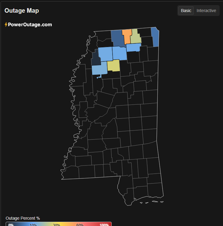
After 2 weeks the power is still out in parts of N MS...down to about ~16K #mswx
1
1
8
1,270
Jan 21
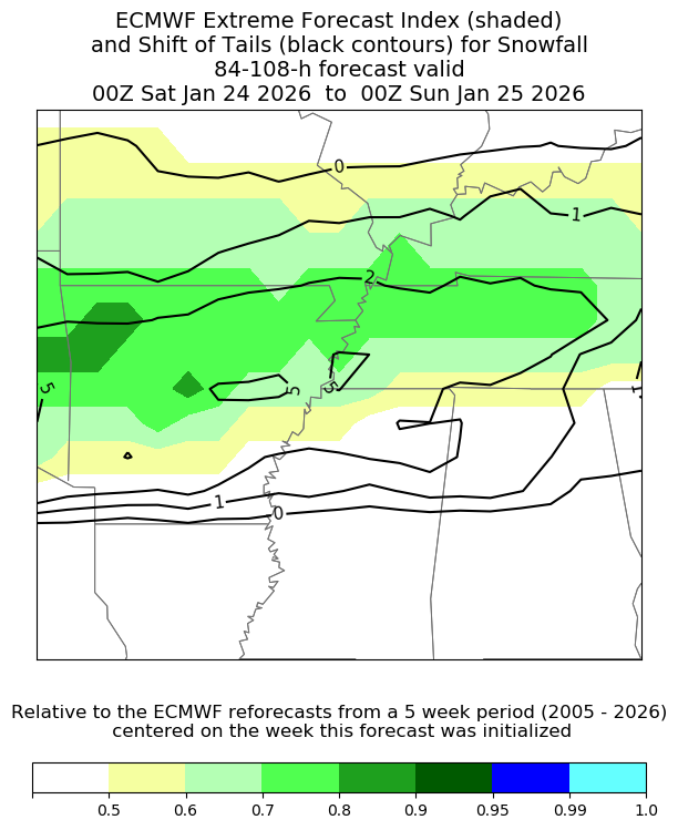
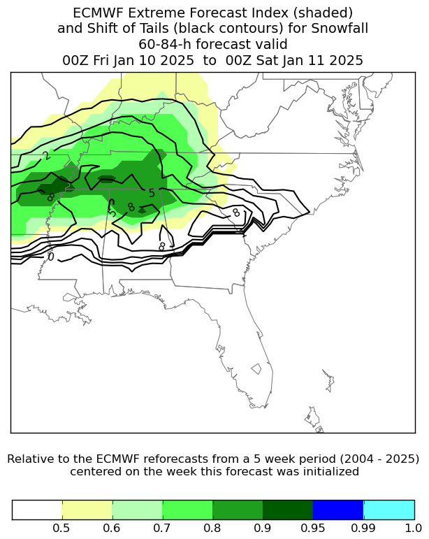
The ECMWF EFI is really showing the extreme snowfall amounts within the ensemble system. Shows how extreme the EPS 90th percentile snowfall totals are compared to climatology.
5
418
4 Aug 2025
Repost: Logan is still fundraising for this Eagle project. He's replacing birdhouses at the Bartlett Animal Shelter. If you're interested in helping out with a donation, I've left the link below. Feel free to share. Can do CashApp or Venmo, too!
gofund.me/0c13e9c6
10
4
20
476
27 Jul 2025
Hey, @grok, who was the most famous person to visit my profile? It doesn't need to be a mutual, don't tag them, just say who it was.
3
13
592
16 Jul 2025
Logan is starting the fundraising for this #EagleScout project. He's replacing birdhouses at the Bartlett (TN) Animal Shelter. If you're interested in helping out with any donations, I've left the link below. Feel free to share. #BSA
gofund.me/61bd1492
2
2
19
434
11 Jul 2025
Logan is starting the fundraising for this #EagleScout project. He's replacing birdhouses at the Bartlett (TN) Animal Shelter. If you're interested in helping out with any donations, I've left the link below. Feel free to share. #BSA
gofundme.com/f/support-logan…
1
9
199
4 May 2025
I keep seeing a lot of questions on social media threads about the omega block. Is that our next trending old meteorology term?
5
221
30 Apr 2025
Potty foul
30 Apr 2025

WATCH: Person struck by porta potty as strong storms and winds hit State College, Pennsylvania.
1
6
273
6 Apr 2025
The past four days have been incredible and exhausting. The amount of severe weather and flooding we've dealt with surpasses anything in my career. Supreme kudos are due for my colleagues at the NWS and the weather enterprise in general. What a team effort.
4
30
425
6 Apr 2025
I certainly want to thank my NWS Memphis coworkers for their tireless and selfless work over the past several days. We have a long way to go to clean up the mess, but we'll get there.
1
10
156
6 Apr 2025
I also want to thank surrounding NWS offices, media partners, and public safety officials. Special thanks to WFOs Huntsville and Jackson for providing vital assistance!
1
3
105
23 Jan 2025
That is insane!
22 Jan 2025

This is more snow in one day than Pensacola picked up in the previous 124 years combined
8.0" fell in total from 1900 to 2024
That's insane
3
425
10 Jan 2025
Dual-pol radar certainly has applications beyond severe weather. Here we can see the areas where the "warm" layer aloft is melting snowflakes south of Memphis. This is resulting in some mixed precipitation across north MS.
1
10
582
10 Jan 2025
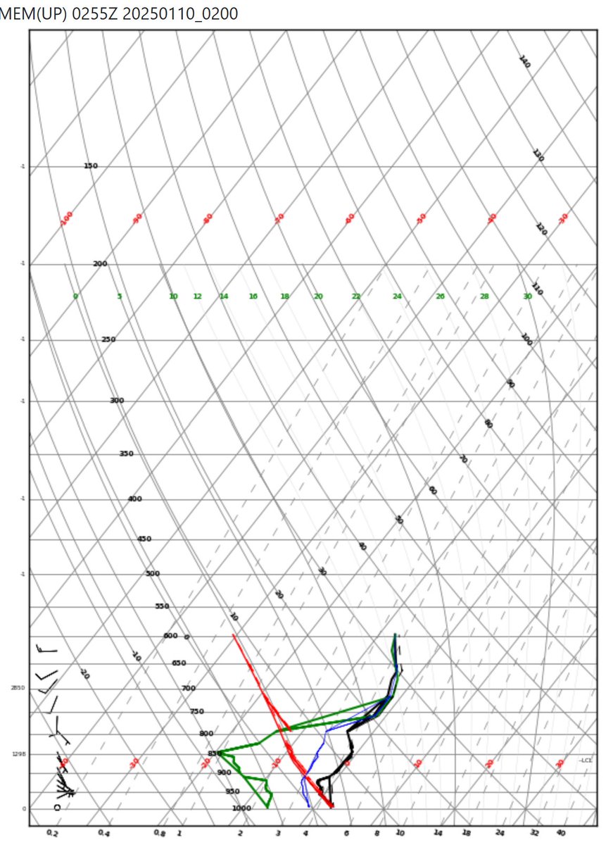
The 0255 UTC ACARS sounding from #Memphis is just below freezing aloft. Still plenty of dynamic cooling to occur between the surface and 750 mb as the snow sublimates in the dry layer. Easy to see why sleet is being reported to the south.
1
3
463
8 Jan 2025
The Shift of Tails on the Extreme Forecast Index is really catching my attention.
2
1
14
875