
Joined March 2010
- Tweets 8,328
- Following 12
- Followers 14,962
- Likes 239
3,952 Photos and videos


Jun 12
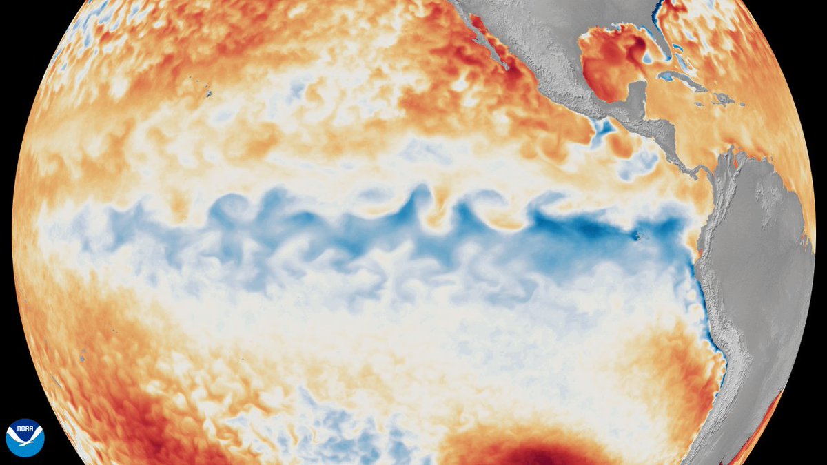
The U.S. National Weather Service announced on Thursday, June 11, that El Niño has developed in the tropical Pacific.
🎥 This animation from NOAA Satellites shows the change in sea surface temperature anomalies in the tropical Pacific Ocean since the beginning of 2026, revealing the emergence of #ElNiño.
It's important to note that the U.S. National Weather Service uses different criteria to declare El Niño than Australia's Bureau of Meteorology. The Bureau is yet to declare the arrival of El Niño, but will likely do so in the coming months.
1
10
846
Jun 12
Parts of #WesternAustralia have recorded their wettest June day in years as a northwest cloudband caused widespread #rain across the state. ☔️ This system will now move east, bringing rain across parts of South Australia, Victoria, Tasmania, NSW, and the ACT this weekend.
weatherzone.com.au/news/nort…
1
4
479
Jun 11
Australia could be in for an unusually dry and warm #winter and #spring this year, as a developing #ElNiño causes high pressure systems to dominate Australia’s #weather patterns in the coming months.
Take a look at the Rainfall, Temperature, and Atmospheric Pressure maps in our latest story. 👇
weatherzone.com.au/news/el-n…
1
7
12
831
Jun 10
Showers are soaking large parts of eastern Australia on this unseasonably warm winter Wednesday ☔️, as a #cloudband stretching from #Queensland to #Tasmania crosses the continent. weatherzone.com.au/news/vast…
🎥 You can see the cloudband and #rain in this combined satellite and radar loop for the 4 hours to 11:30am AEST on Wednesday, June 10, 2026.
2
7
708
Jun 10
Sea surface temperatures in the tropical Pacific Ocean have just passed Australia’s threshold for El Niño. 🌡️ #ElNiño #Climate
weatherzone.com.au/news/key-…
1
7
16
1,162
Jun 9
#Melbourne has only seen 20°C in June twice in the last 20 years, but that's the forecast this Friday on what will be a very warm week for early winter across a wide area of southeastern Australia. 🌡️ weatherzone.com.au/news/rare…
Image: Predicted Australian temperature anomalies at 4pm AEST on Friday, June 12, 2026. Source: Tropical Tidbits
8
18
1,331
Jun 9
Can you guess the four features labelled in this satellite image? 👀
Hint: They are not all clouds.
2
2
4
769
Jun 9
Australia’s winter 2026 #bushfire outlook has been released by the Australian and New Zealand National Council for fire and emergency services (#AFAC), 🔥 predicting increased #firerisk across the northern parts of #WesternAustralia and a large area of central and northern #NSW.
weatherzone.com.au/news/wint…
1
4
474
Jun 9
The World Meteorological Organization has not minced its words when issuing a clear climate warning for the coming months: “Prepare for El Niño.”
weatherzone.com.au/news/worl…
3
8
795
Jun 5
Whether you're in for a long weekend or just the regular 2-day version (in WA and Qld), conditions should be remarkably pleasant for June across virtually the whole of the country! weatherzone.com.au/news/cold…
5
449
Jun 4
The 2026 Australian ski season will kick off this Saturday, June 6, with at least 10 cm of natural #snow on the ground at most resorts, plus whatever they can pump out over the next 48 hours through snowmaking. ❄️
weatherzone.com.au/news/snow…
3
6
516
Jun 3
Layer up, Melbourne, and don't forget the umbrellas. This Wednesday is chilly but Thursday could potentially be both the wettest and coldest day of 2026 to date.
weatherzone.com.au/news/wint…
2
7
441
Jun 2
#Tasmania and #Hobart just had their warmest May on record based on maximum temperatures, with Victoria and New South Wales also having an exceptionally warm month. 🌡️ weatherzone.com.au/news/warm…
1
3
5
598
Jun 2
A strong low pressure system and associated #coldfront are funnelling wild #winds across southeastern Australia this Tuesday, with severe weather warnings for potentially damaging winds issued for parts of #Victoria, #SouthAustralia, #NSW, and the #AustralianCapitalTerritory. ⚠️🌬️
weatherzone.com.au/news/seve…
1
3
584
Jun 1
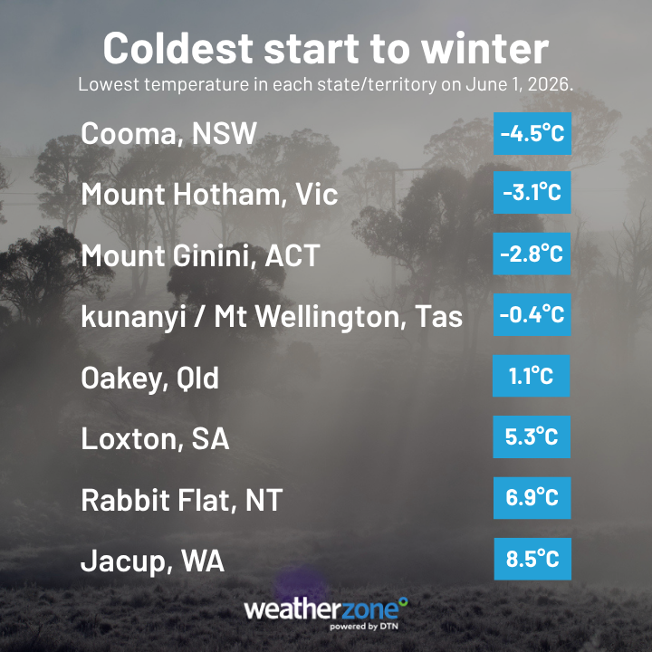
Which part of Australia had the coldest start to winter? 🌡️
Today, June 1, marks the first day of #winter in Australia. For many, it was a fittingly cold start to the season, with temperatures dropping below zero degrees in four states and territories, and even dipping to a nippy 1.1°C in Queensland! weatherzone.com.au/news/whic…
1
2
6
1,061
Jun 1
A light dusting of fresh #snow has coated the alpine areas of #NSW, #Victoria and #Tasmania to start winter, with heavier snowfalls likely later this week just in time for Saturday’s official opening of the 2026 Australian ski season. ❄️
weatherzone.com.au/news/ligh…
5
8
788
May 31
Watch as this 'bombing' low 🌀 rapidly intensifies as it impacts the southwest of WA. The central pressure fell 18hPa in these 12 hours.
While much of the heaviest rain has now fallen (widespread 20-50mm), winds are yet to peak, reaching their maximum around 6-8pm WST Sunday night.
⚠️Forecast weather impacts to come:
💨 Wind gusts of 125-155km/h along the coast, and above 90km/h possible from Leeuwin to Albany, inc. Perth
🌊 Significant wave heights of 6.5-7.5m (maximum heights up to 15m) at Rottnest Island and the exposed coasts. Tides will also be abnormally high, potentially exceeding the highest tide of the year
🌪️ Cold-season tornadoes possible with isolated thunderstorms. A further 15-30mm of rainfall is forecast
To find warnings, observations and more information visit weatherzone.com.au/
11
21
1,813
May 29
Damaging winds are likely for #Perth and parts of southwest #WesternAustralia, especially near the coast, as a cold front roars in later this weekend.
weatherzone.com.au/news/extr…
1
2
589
May 29
Heavy rain and #thunderstorms inundated parts of #NSW on Thursday into Friday morning, with the State Emergency Service performing five #flood rescues and responding to more than 300 incidents in 24 hours. ⚠️
weatherzone.com.au/news/mult…
6
496
May 28
🎥 This video shows enhanced water vapour satellite images from the last three days as an upper-level cut-off low develops over southeastern Australia. ☔️⚡️ This system is causing areas of heavy rain and thunderstorms across parts of Queensland and New South Wales today.
1
9
30
1,913