
568 Photos and videos


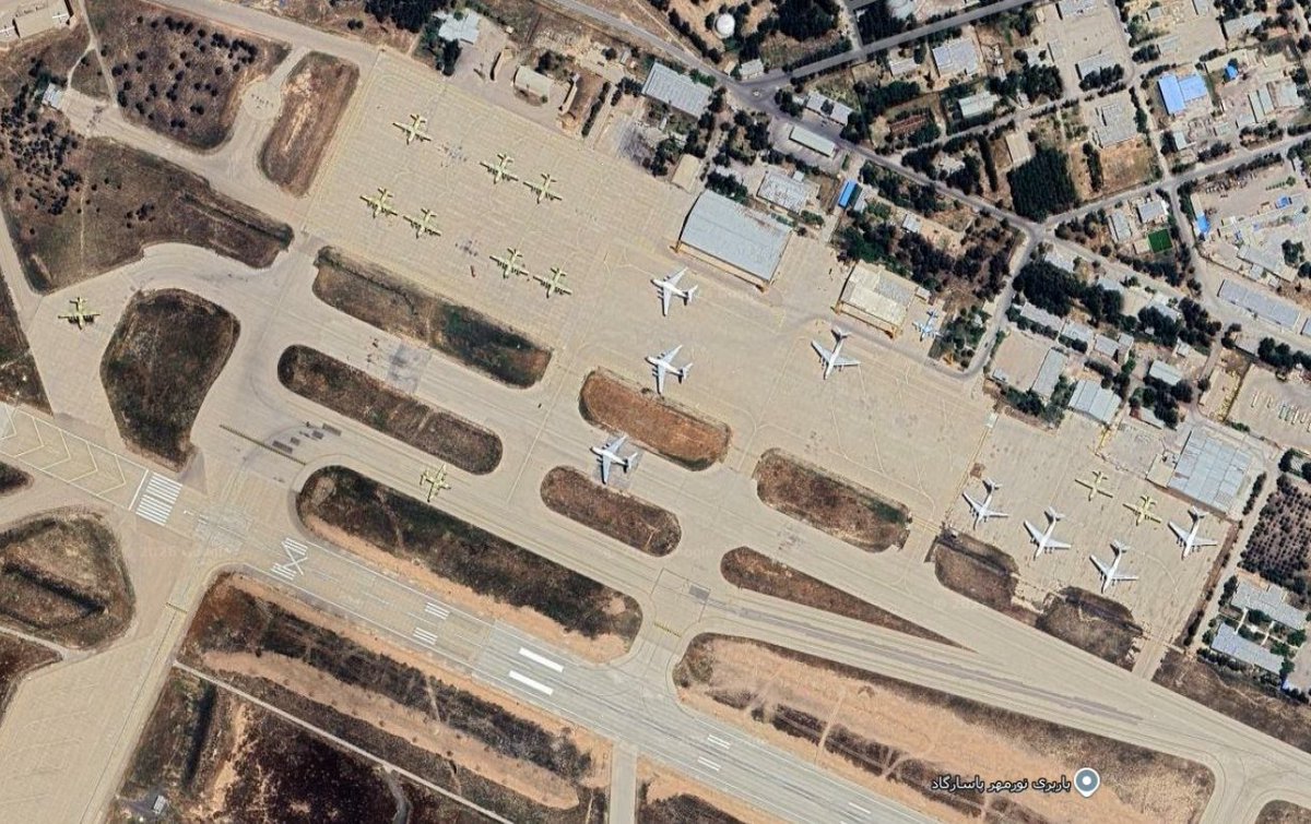
Israeli/US air strikes at Iran's Shiraz International Airport showing various planes (including civilian) been hit. Absolute carnage! 😬Looks like the main strikes were in the opening days of the war. Likely 28 Feb to Mar 5. High res Google imagery likely from late 2025.
1
12
45
10,567
Amir retweeted

Jun 12
🔥Satellite imagery appears to show damage to a building at Isa Air Base in Bahrain, a strategic facility known to host U.S. military assets.
Explore and Compare: tinyurl.com/tm6s7pnt
A large mark can be seen in the before/after (Jun 2/7)
#MiddleEast #IranWar #Bahrain
3
24
115
49,902
Satellite imagery captured today over Al-Azraq AB in Jordan, home to F-35 fighter aircraft, appears to show several scar marks consistent with potential Iranian missile impact sites (not confirmed). Direct map link: soaratlas.com/satellites?pos…
1
6
22
7,850
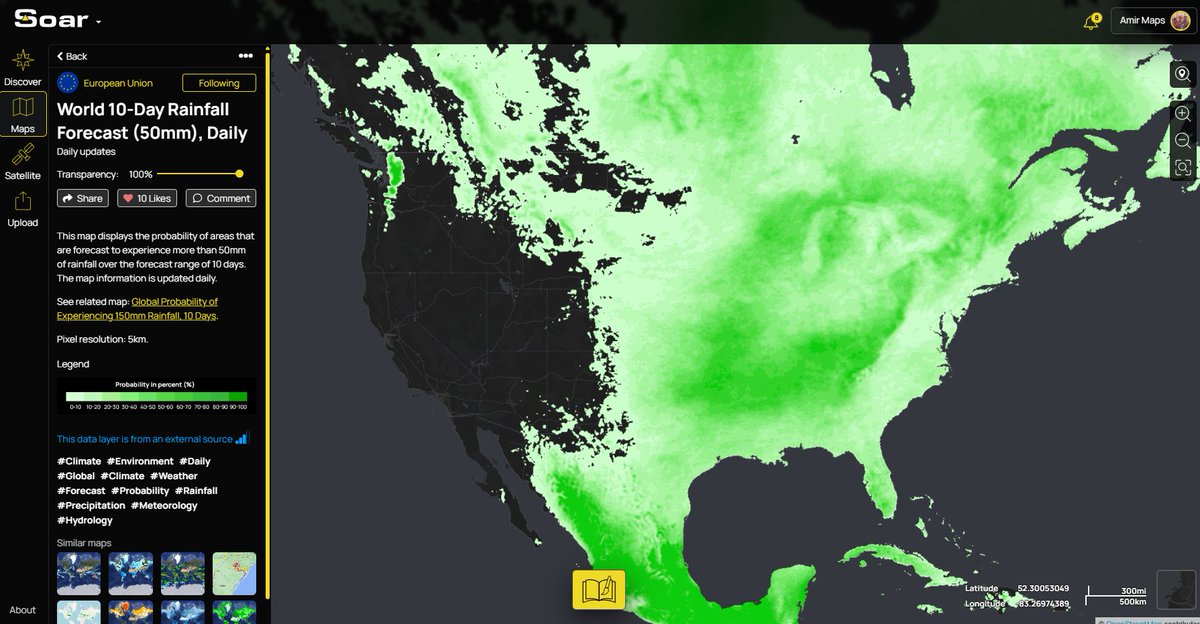
Looks like its going to be a wet start to the World Cup in the US! 🌧️⚽️ unless you are on the west coast ☀️CC: @SoarAtlas
Full map link: soaratlas.com/maps/global-wo…
2
3
1,296
Amir retweeted
Jun 9
Satellite imagery from June 8 shows a possible strike at Ramat David Airbase.
Explore and Compare: tinyurl.com/4x843jcc
Although the imagery is low-res, a white patch where the hangar previously stood is visible. Thanks @tom_bike for the find.
#MiddleEast #Israel #IranWar

Iran 🇮🇷 ballistic missile hits damage spotted TODAY in Israel 🇮🇱 Ramat David AB 👇 at
32.6621, 35.1815
in northern Israel, near Haifa; targeted yesterday (June 7, 2026).
3
26
136
33,568
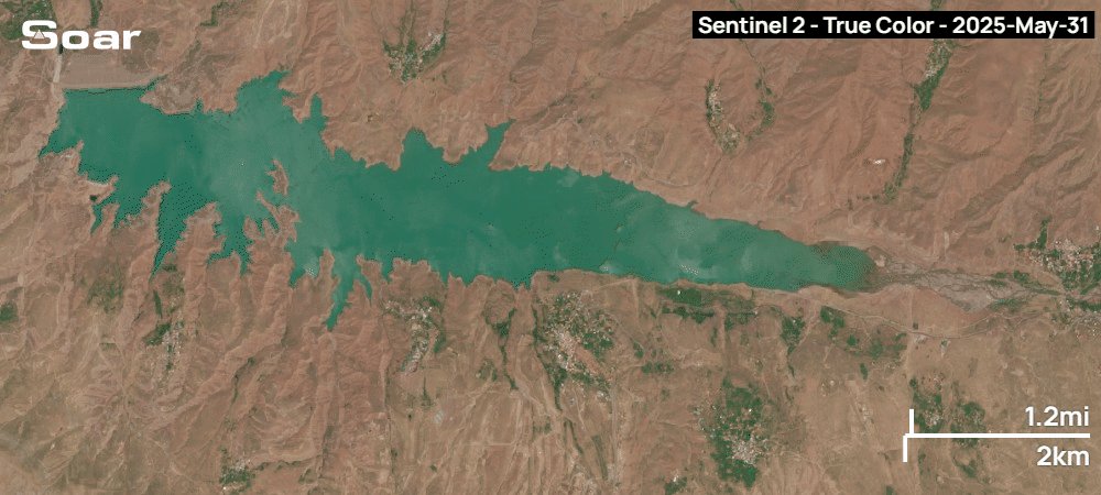
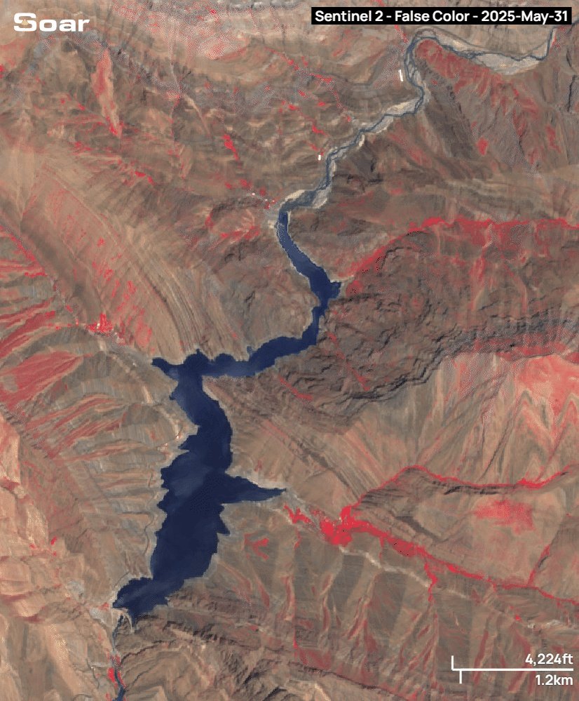
Dont believe what you see online. Zayandeh River in Isfahan Iran is NOT flowing. Here is todays satellite imagery vs May 2023. Clearly see there is no water in the river in Natural False Colour Water Detection modes. CC: @SoarAtlas @IranianPlateau @ResindScientist @hadinik
6
11
1,251
I think the technical term for this is 'effen big explosion' 🤯 Measuring the New Glenn rocket Blue Origin setback using @SoarAtlas tools. The impact area radius is ~600m! A miracle no one was injured or killed 🙏
1
1
218
Amir retweeted

May 30
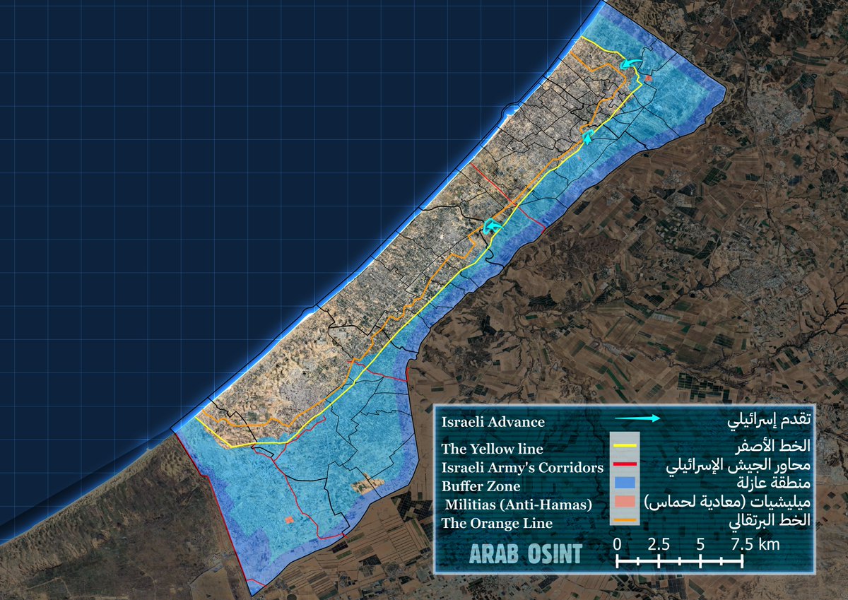
#تحديث قطاع غزة 30.5 :
عدنا.
-تقدم للجيش الإسرائيلي إلى قاعدة المساعدات الأمريكية في نيتساريم
-تقدم محدود في شمال القطاع.
لمشاهدة التحديث : soaratlas.com/draw/2970
الخريطة (بلغتين) : shorturl.at/7vOLz
1
8
39
4,570
Just a few Iranian F14s (plus an F5?) at the Isfahan Air Base in 1978 via declassified US military satellite imagery CC: @SoarAtlas @BabakTaghvaee1 @mhmiranusa @IranObserver0 @tom_bike
4
4
56
13,188
These declassified US satellite images are nuts! What a shot of the F4 taking off in 1977. Phantom delights! 👻🇮🇷 Hot link here: soaratlas.com/maps/asia-iran… CC: @mhmiranusa @BabakTaghvaee1 @AmirIGM
2
12
1,280
Amir retweeted
May 28
The recent release of updated high resolution satellite imagery over Rafah, Gaza by Google has revealed further widespread devastation since the previous imagery.
Explore and compare on Soar: tinyurl.com/4npvyxjm
3
3
11
1,449
Amir retweeted
May 26
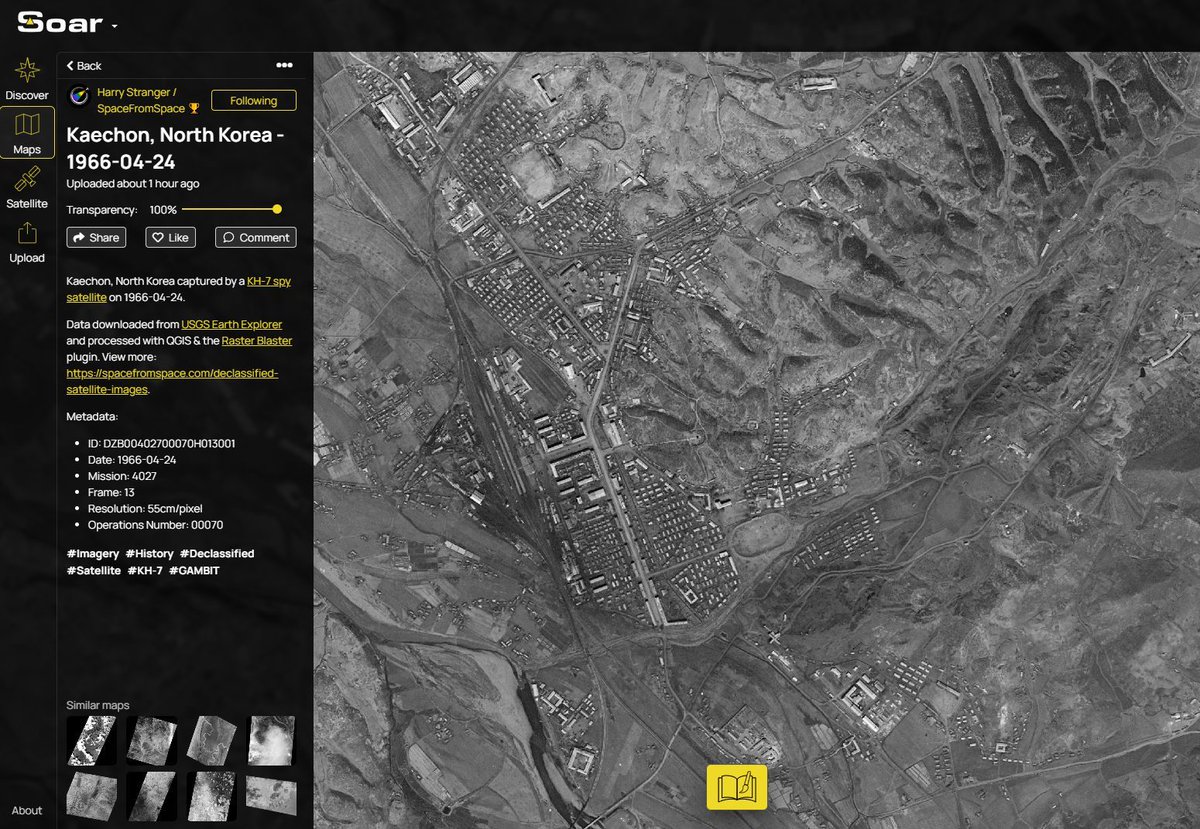
Back in 1966, spy satellites captured the city of Kaechon, North Korea during the height of the Cold War. The imagery offered a rare glimpse inside one of the world’s most isolated nations nearly 60 years ago.
Explore and Compare: tinyurl.com/yfktpxry
2
9
1,128
Amir retweeted
May 25
Sentinel-2 satellite imagery shows a stunning before and after of where an underwater volcano in the Bismarck Sea is currently erupting.
Compare the images yourself: tinyurl.com/5a453p8d
1
6
22
2,903
Amir retweeted
May 21
A new map published Persian Gulf Strait Authority details the regulatory jurisdiction defined by the Islamic Republic of Iran for the management of the Strait of Hormuz.
Explore: tinyurl.com/4rxubcur

4
12
1,881
Amir retweeted
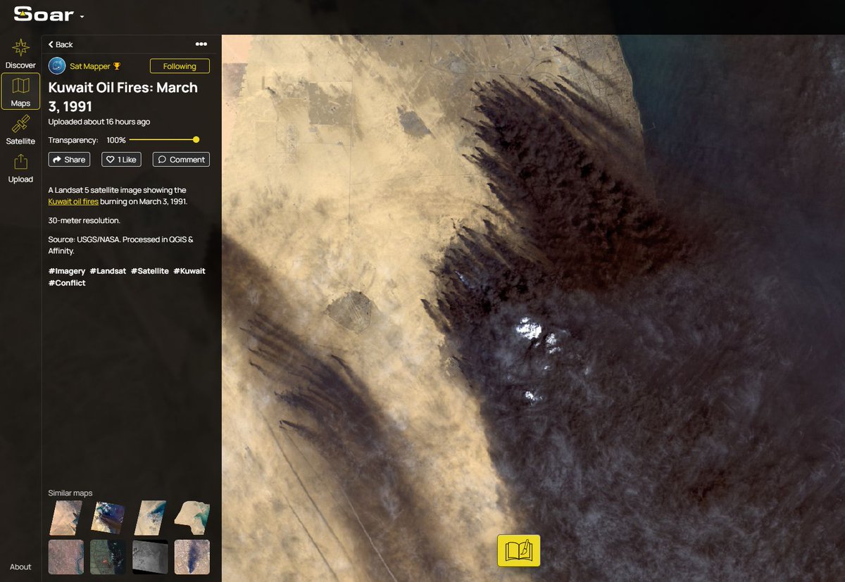
May 21
Back in 1991, oil fires burned out of control after Iraqi forces ignited more than 600 oil wells across Kuwait. Satellite imagery captured those massive smoke plumes stretching hundreds of kilometers.
Explore and Compare: tinyurl.com/6pxv86xa
2
20
1,963
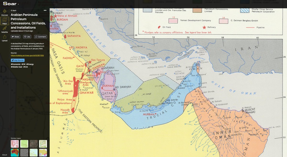
Just found this amazing declassified CIA map on @SoarAtlas showing the 'Trucial Coast' of the Persian Gulf in 1956. By 1971 the Trucial States became what is now the UAE. Politics aside, its been incredible journey for the UAE 🇦🇪 soaratlas.com/maps/arabian-p… @gulf_news @MarioNawfal
1
2
24
8,852
Amir retweeted
May 18
🛰 This is the latest cloud-free satellite imagery of the area where a massive explosion was spotted in Israel.
It appears to have occurred at Israel’s Sidot Micha base, inside a rocket engine test facility operated by Tomer. New imagery will be released in the coming days.
2
27
112
13,527
Amir retweeted

地図・衛星画像のデジタルアトラス Soar Atlas 🛰️
世界中のマップ・衛星画像・ドローン画像を集約。Sentinel-2 / Landsat 8/9の衛星画像を検索・ダウンロードでき植生・水域・火災検出など19種フィルタで可視化。ドローン画像の共有・販売にも対応。
soaratlas.com
#foss4g #foss4gj
1
25
144
8,779
Soar in 3D is going to be 'lit' as the kids say 😅 Cant wait for the release! All maps on Soar will be available in 3D, yes that even means Sentinel images. You can add elements, text, measurements, models (yes thats a 🍔) and even create a fly through then export as a video.

1
6
1,030
Amir retweeted
May 8
Satellite images from The Washington Post independently confirmed damage at the U.S. base Camp Arifjan in Kuwait.
Georeferenced for comparison here: tinyurl.com/3azstf9h
🚨Notice Google Maps has pixelated the area underneath? As you zoom, parts fail to load.
1
3
13
2,795