
3DR makes Site Scan, the industry leading drone data platform for construction, engineering, and mining teams. Start flying for free at 3DR.com
Joined June 2010
- Tweets 4,658
- Following 172
- Followers 118,527
- Likes 2,876
1,107 Photos and videos


3DR retweeted

13 Mar 2021
Pioneers in the space @chr1sa & @Jrdmnz picked up on the opportunity with @3DRobotics producing the first Pixhawk variants as early as 2012
diydrones.com/profiles/blogs…
11
9
21
3DR retweeted
13 Mar 2021
A few years later, @3DRobotics started producing the Pixhawk FMUv2, the all might, and industry disruptor known as Pixhawk 1
This is by far the most widely known variant and industry enabler.
diydrones.com/profiles/blogs…
2
5
19
3DR retweeted
17 Mar 2021
This one is for all the 🦀 rustaceans in the Community. This project got started when I was still working at @3DRobotics by @trimryan and is now maintained by @kevinmehall both some of the greatest engineers I have ever had the pleasure to work with.
17 Mar 2021

🦀 Good news Rustaceans. The mavlink-rust team just released v0.9, bringing increased performance, support for embedded targets, and a much more robust set of tests, which are now running on GitHub Actions. #OpenSource #Drones #Rust
👉 Check-it out on bit.ly/3vzpDMb

2
5
18

14 Jan 2021
14 Jan 2021

Really exciting episode of Gradient Dissent, where Chris Anderson (@chr1sa) shares his story about Robocars, Drones and WIRED magazine! Chris is an amazing storyteller, so feel free to tune in for the premiere in 5 minutes!😀

6
10
20
3DR retweeted

23 Nov 2020
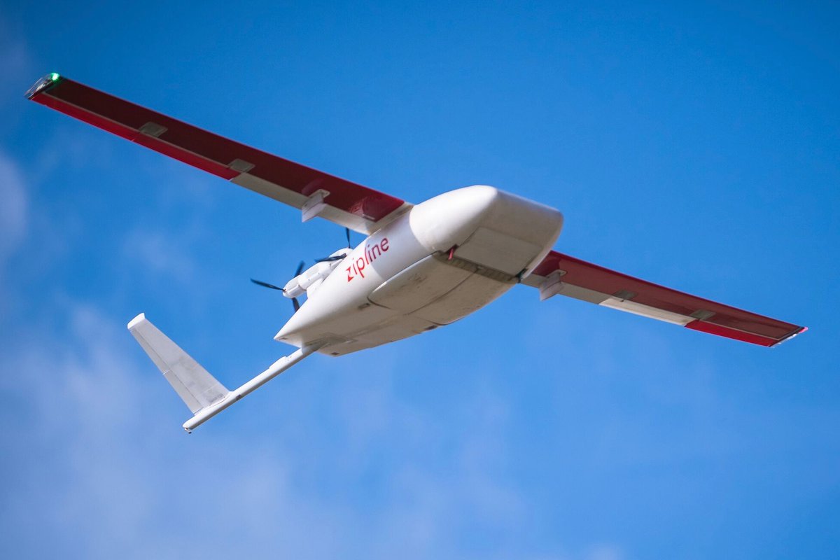
The FAA has proposed airworthiness criteria to define a path to type certification for 10 drone companies: @3DRobotics, @AiroboticsUAV, @Amazon, @Fly_Flirtey, @flytrexcom, @matternet, @PerceptoDrones, @Telegrid, @Wingcopter & @zipline. bit.ly/3lZ8ZjJ #FlySafe #DroneFirst
4
40
81
3DR retweeted

23 Nov 2020
Great news for @3DRobotics: We're among the 10 companies (including Amazon) that the FAA has approved for its new Type Certification process that will allow flight beyond visual line-of-sight, over people and finally breaking the 1:1 aircraft:pilot ratio
faa.gov/news/updates/?newsId…
10
10
114
3DR retweeted
20 Aug 2020
The US government just approved 5 US-made drones for purchase, all based on the @Dronecode @PX4Autopilot standard. Great news for open source and the whole Dronecode ecosystem
theverge.com/2020/8/20/21376…
14
40
151
3DR retweeted
7 Jul 2020
My talk on PX4 and FAA certification is coming up at 1:45 PST today on the PX4 Dev Summit livestream. Includes some cool new stuff on quantifying the "fidelty" of drone simulation sched.co/cjNl @px4autopilot #PX4DevSummit
3
3
16
3 Mar 2020
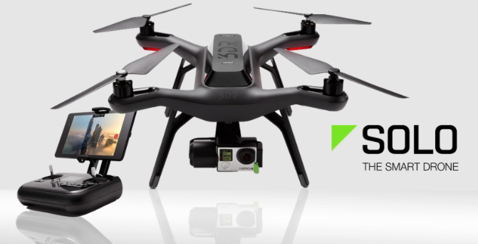
Cool use of a @3DRobotics Solo to do wind measurements by seeing how hard the drone has to work to fight the wind at different altitudes
linkedin.com/posts/shane-ros…
3
9
24
15 Jan 2020
Big News with Site Scan becoming part of @Esri.
15 Jan 2020

Delighted to report that in December the @3DRobotics Site Scan drone data capture and analysis suite became part of @Esri, the geospatial software giant. Great deal for both companies and Site Scan's customers. Read more about that in my post here: linkedin.com/posts/chrisande…
3
4
24
6 Dec 2019
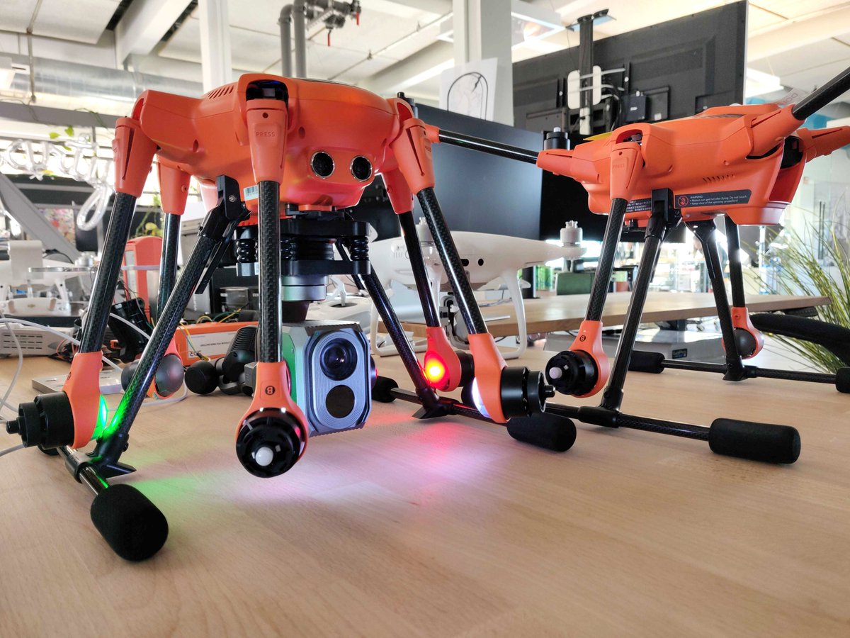
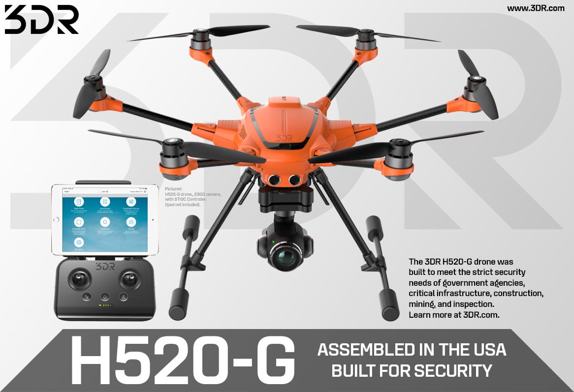
A little Site Scan thermal testing for the 3DR H520-G.
#thermalmapping #drones #opensource #autonomous #fly3DR
5
20
64
15 Nov 2019
3DR’s one-click integration with Esri ArcGIS Online offers Site Scan users the ability to transfer their data outputs into their ArcGIS Online account. The integration is available to users today as part of Esri's new ArcGIS Drone Collection: esri.com/en-us/landing-page/…
2
9
27
7 Nov 2019
3DR invites you to join the Fall Feature Release webinar to hear the latest updates for Site Scan, the drone data management software.
When: Thursday November 14th, 2019 at 10:00am PST
Use the following link to register:
3dr.com/resources/webinars/s…
#3DR #Drone #Mapping #Webinar
1
4
10
4 Nov 2019
Watch our CEO and 3DR team featured in Microsoft Ignite 2019 Vision Keynote. Our collaboration with Microsoft includes utilizing AirSim and Azure cloud for a new FAA drone certification process. Learn more about @Microsoft autonomous systems at msft.social/2qgSxN #MSIgnite
1
3
18
3DR retweeted

4 Nov 2019
Be a part of #MSIgnite.
Watch @SatyaNadella's vision keynote livestream now. 👇 x.com/i/broadcasts/1lDxLoRdn…
12
330
664
1 Nov 2019
Now offering a free month of Site Scan Personal to see what the best-in-class drone analytics platform has to offer. Fly, process and download your data for your next project. No credit card needed to sign up today at 3dr.com/trial/
#3DR #cloudprocessing #drones #flysafe
5
12
28 Oct 2019
The 3DR and @Esri partnership has evolved to offer Esri customers an end-to-end drone data and analytics solution that seamlessly integrates 3DR Site Scan with Esri ArcGIS Online. Read more at: businesswire.com/news/home/2…
#3DR #Esri #ArcGIS #3drsitescan #drones #aerialmapping
8
15
25 Oct 2019
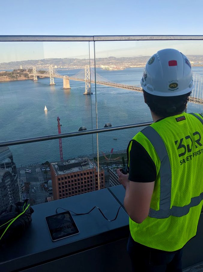
Out of the office and into San Francisco! 3DR on site and flying high with the Mavic 2 Pro. #3DR #3drobotics #3drsitescan #drone #surveying #mapping #dronecapture
1
12
22 Oct 2019
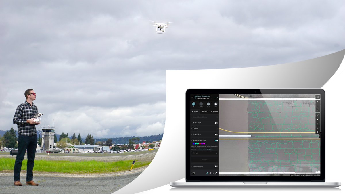
3DR releases major updates to Site Scan with new features including automatic GCP detection, checklists, variable slope vertical scan, and more. For full details on the Fall 2019 release head over to our blog: 3dr.com/blog/3dr-releases-ma…
#3DR #dronemapping #drone #construction #AEC
6
11
19 Oct 2019
Start your free trial of Site Scan to create maps and models and share data with up to 10 people! Sign up today at 3dr.com/trial/signup/
#3dr #sitescan #dronemapping #dronesforconstruction #realitycapture #datamanagement #fleetmanagement #drones
1
5