
@winknews Meteorologist|Retired Student-Athlete|@FloridaTech Alumni|FMR @fox4now, @cbs4rgv, @KEZI9, & @NewsCenter1
Joined October 2011
- Tweets 35,341
- Following 7,293
- Followers 2,491
- Likes 63,064
12,512 Photos and videos
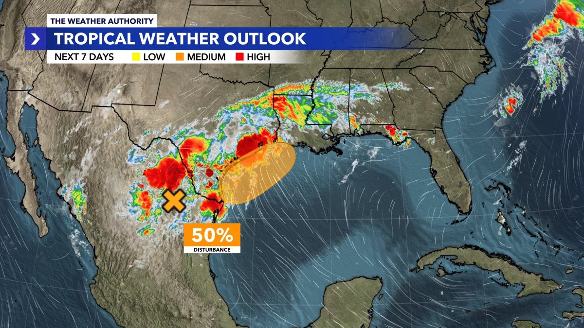


The disturbance over northeastern Mexico has now been designated Invest 90L and is expected to move into the northwestern Gulf later this week.
The National Hurricane Center has increased development odds to 40% over the next 48 hours and 50% over the next 7 days, with a short-lived tropical storm possible Wednesday into Thursday.
Regardless of development, the biggest concern is widespread heavy rainfall and flooding across parts of Texas, Louisiana, and Mississippi. Flash flooding, river flooding, gusty winds, and coastal flooding are all possible.
📍 For Southwest Florida, there is no threat at this time. Forecast guidance keeps the system well west of Florida, with impacts focused along the northwestern Gulf Coast.
We’ll continue to monitor Invest 90L and provide updates as new information becomes available.
2
134

Jun 14
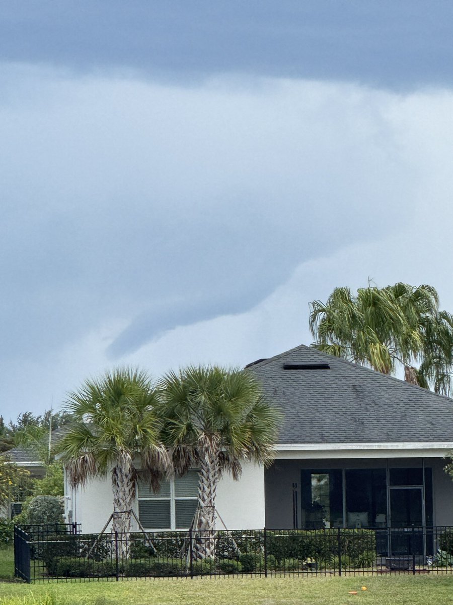
What a sky…
Jun 13

Fight night energy is taking over DC.
UFC Freedom 250 is almost here. 🇺🇸
1
130
Jun 13
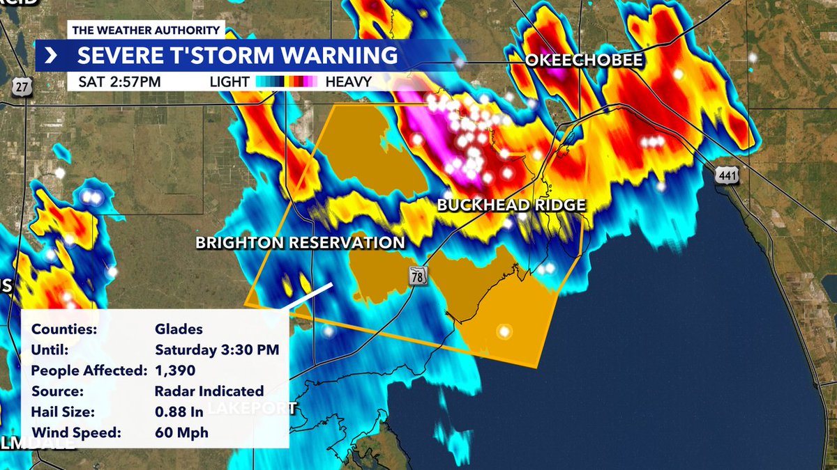
*SEVERE T'STORM WARNING* issued for Glades County until 6/13 3:30PM. Track storms with Southwest Florida's @WINKNews Live Doppler 3X: winknews.com/weather/
37
Jun 12
*SEVERE T'STORM WARNING* issued for Collier, Mainland Monroe County until 6/12 5:45PM. Track storms with Southwest Florida's @WINKNews Live Doppler 3X: winknews.com/weather/
54
Jun 12
*FLOOD ADVISORY* issued for Charlotte County until 6/12 6:15PM. Track storms with Southwest Florida's WINK Live Doppler 3X: winknews.com/weather/
37
Jun 11
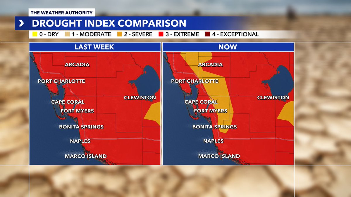
New drought update is out and we are continuing to see improvements thanks to recent rainfall---that said we are still in severe drought and need about 34 inches of rain over the next 3 months to remove the drought.
48
Andrew Shipotofsky retweeted

El Niño conditions are present and expected to strengthen into the Northern Hemisphere winter 2026-27. An #ElNino Advisory is now in effect. #ENSO cpc.ncep.noaa.gov/products/a…
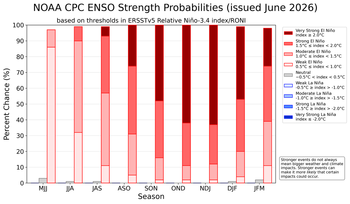
ALT A bar chart showing the chance of El Niño (red bars), ENSO-Neutral (grey bars), and La Niña (blue bars) provided for 9 upcoming, overlapping 3-month seasons (each letter represents a month, for example, F = February). The color shading within the bars indicates the chances of different categories of El Niño or La Niña strength (weak, moderate, strong, and very strong). Alternatively, the table at the internet address below presents the percent chances of each strength category in numerical form. https://cpc.ncep.noaa.gov/products/analysis_monitoring/enso/roni/strengths/
10
195
343
82,543
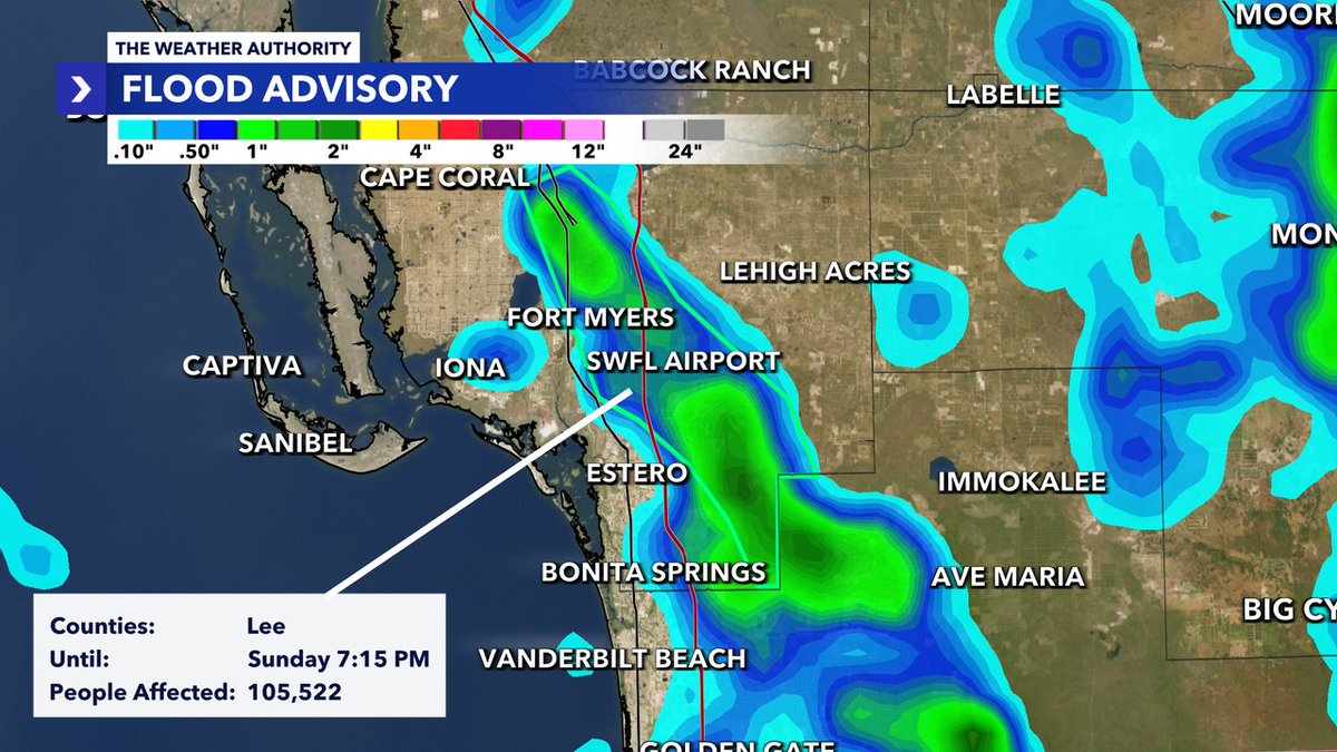
Jun 10
*FLOOD ADVISORY* issued for Lee County until 6/10 6:15PM. Track storms with Southwest Florida's WINK Live Doppler 3X: winknews.com/weather/
45
Jun 10
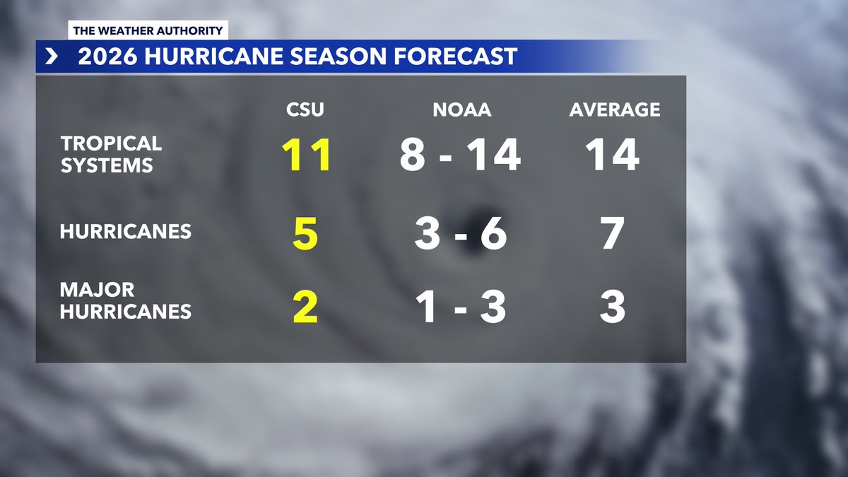
Thanks in part to the developing El Niño, Colorado State University has lowered its forecast for the 2026 Atlantic Hurricane Season.
April Outlook
• 13 Named Storms
• 6 Hurricanes
• 2 Major Hurricanes
Updated June 10 Outlook
• 11 Named Storms
• 5 Hurricanes
• 2 Major Hurricanes
While the forecast is trending downward, it only takes one storm to make it an active season for your community.
1
2
101
Jun 10
We have our first official Area of Interest of the 2026 Atlantic Hurricane Season!
The National Hurricane Center is monitoring a potential area of development in the Bay of Campeche, which is expected to originate from the remnants of Tropical Storm Christina after it moves inland across Central America later this week.
At this time, development chances remain low—just 10% over the next 7 days—and environmental conditions are not expected to be particularly favorable for significant strengthening. If a system does form, it would likely move toward eastern Mexico, near southern Tamaulipas or northern Veracruz, by late weekend.
For the United States, the main impact would be an increase in rain chances across Deep South Texas. There is currently no threat to Florida from this potential development.
As always, we’ll keep an eye on it and let you know if anything changes.


1
544

6/8: Ochopee's seismograph picked up seismic activity from the earthquake that occurred just west of Cuba at 2PM.
You can see the up/down oscillations that occurred on the seismograph shortly after 2PM. Thanks for all of the reports! For more info, visit @USGS_Quakes.

3
40
135
12,806


Andrew Shipotofsky retweeted

Jun 8
Notable quake, preliminary info: M 6.4 - 118 km WNW of Mantua, Cuba ow.ly/Rwh7106ztxC
30
152
330
304,878
Jun 8
This is good. I definitely felt the shake
Jun 8

From the National Tsunami Warning Center:
✅ NO tsunami, NO danger from a recent earthquake.
Duty Scientists analyzed the event
at 1400 EDT Jun 08:
M6.4 in the Cuba region.
A Tsunami Information Statement for this event is posted at tsunami.gov
3
288
Andrew Shipotofsky retweeted

Jun 6
There is a lot going on right now on the @Space_Station, but fortunately we are all safe and witnessed a spectacular southern aurora show yesterday thanks to a recent solar event.


327
3,689
28,184
1,449,033
Jun 4
I spy drier air...humidity will be bit lower next few days. This drier air will also drop rain chances into the weekend.
52
Jun 4
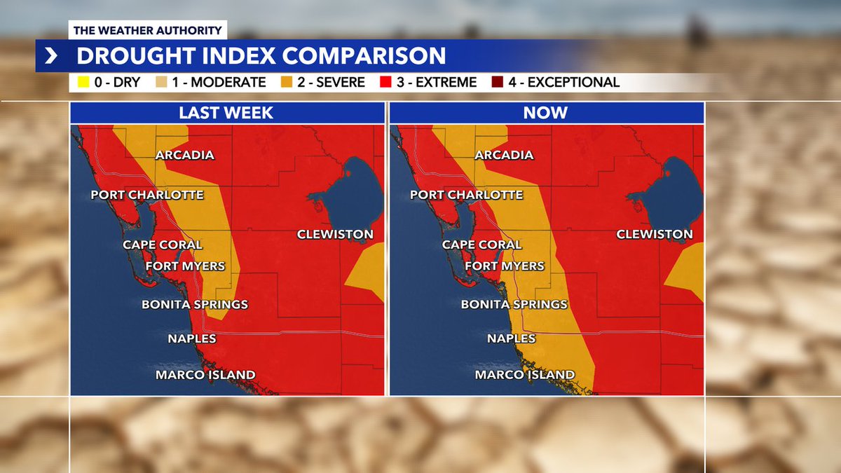
The rainy season is beginning to chip away at drought conditions across Southwest Florida. Areas that were experiencing extreme drought have seen some improvement over the past week.
However, the rainfall deficit remains substantial.
1
51
Jun 3
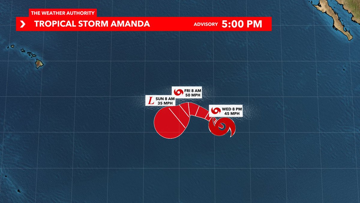
Tropical Storm Amanda formed in the Eastern Pacific Basin today, making it the first tropical system of hurricane season. While nothing has formed in the Atlantic Basin yet, it good reminder we are in Hurricane Season now.
1
105
Andrew Shipotofsky retweeted

Jun 3
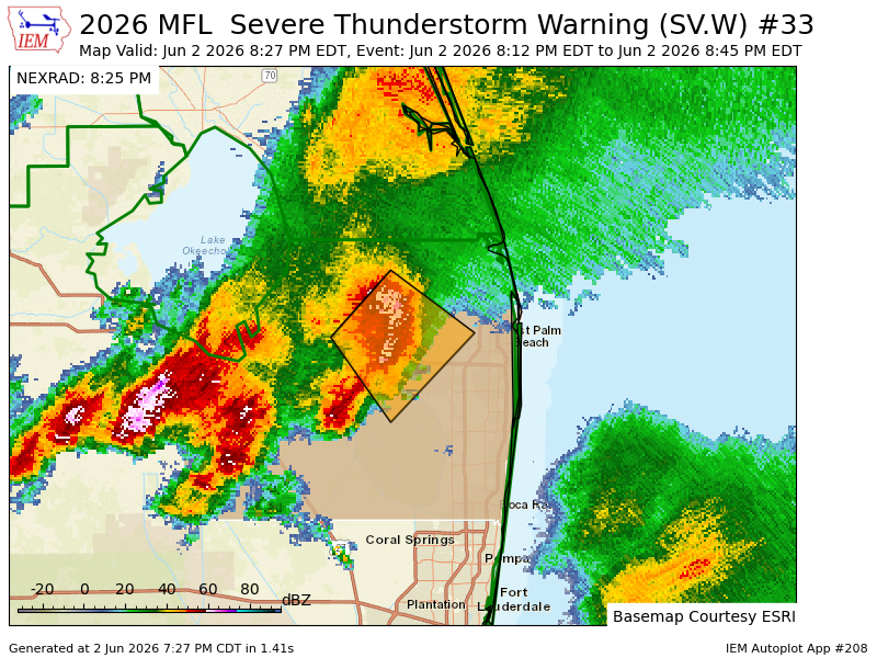
MFL continues Severe Thunderstorm Warning [wind: 60 MPH (RADAR INDICATED), hail: 1.00 IN (RADAR INDICATED)] for Palm Beach [FL] till 8:45 PM EDT mesonet.agron.iastate.edu/vt…
1
64
Jun 2
*SEVERE T'STORM WARNING* issued for Highlands, DeSoto, Hardee County until 6/02 6:15PM. Track storms with Southwest Florida's @WINKNews Live Doppler 3X: winknews.com/weather/
87