FBO for domestic and international avian flights. Home to Tortle, wild chomper of blueberries, the Front Porch Cafe. Skywarn® spotter. Compulsive time-lapser.
The latest infrared satellite this evening (ending at 9:46 PM Saturday evening) continues to show very deep convection primarily to the NW of the state. This intense area of convection is moving in our direction but expected to weaken somewhat before arriving. #arwx
Here is a look at your forecast for the next seven days across the state. Precipitation chances continue for this afternoon with some additional showers over the south for Monday and Tuesday. Temperatures will cool slightly across the north today and statewide Monday. #arwx
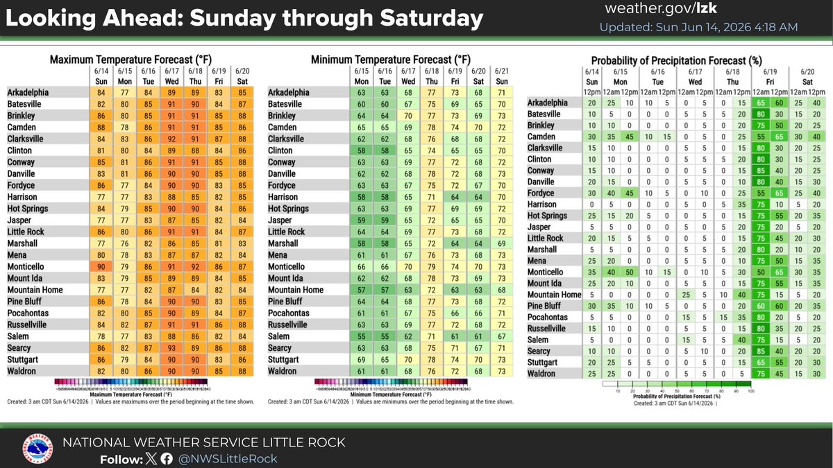
ALT Here is a look at your forecast for the next seven days across the state. Precipitation chances continue for this afternoon with some additional showers over the south for Monday and Tuesday. Temperatures will cool slightly across the north today and statewide Monday before the heat starts to build again.
All signs are pointing to a chance of seeing below normal temperatures for the next 6 to 10 days along with a chance of above average rainfall. Remember these are probabilistic forecasts and just give the percent of seeing above or below normal temperatures and precip. #arwx
ALT All signs are pointing to a chance of seeing below normal temperatures for the next 6 to 10 days along with a chance of above average rainfall. Remember these are probabilistic forecasts and just give the percent of seeing above or below normal temperatures and precipitation.
A check on radar this morning showing the bulk of the light to occasional moderate rainfall south of the I-40 corridor across Arkansas. This activity is expected to continue tracking southeast overall and exit the state completely over the next few hours. #arwx