📡Radar and Lightning Snapshot📸
A low pressure system to the west is bringing plenty of rain today to both Islands.
There are Heavy Rain 🟧Warnings and 🟡Watches, as well as thunderstorm and downpour risks, so check your forecast here: bit.ly/metservicenz
🟡Watches have been issued for Heavy Rain and Strong Winds as the work week comes to a wet and windy close over the upper North Island on Friday
Take some time today tie down any loose items. And with possible heavy rain before dawn, remember to take it easy on the roads🚗🚙
💨 Squally showers and thunderstorms across the upper North Island on Sunday morning and afternoon may bring brief damaging wind gusts to spots where they touch down 🎯
🟠 Then, from Sunday afternoon warnings and watches are in place for widespread severe gale southwesterlies 🟡
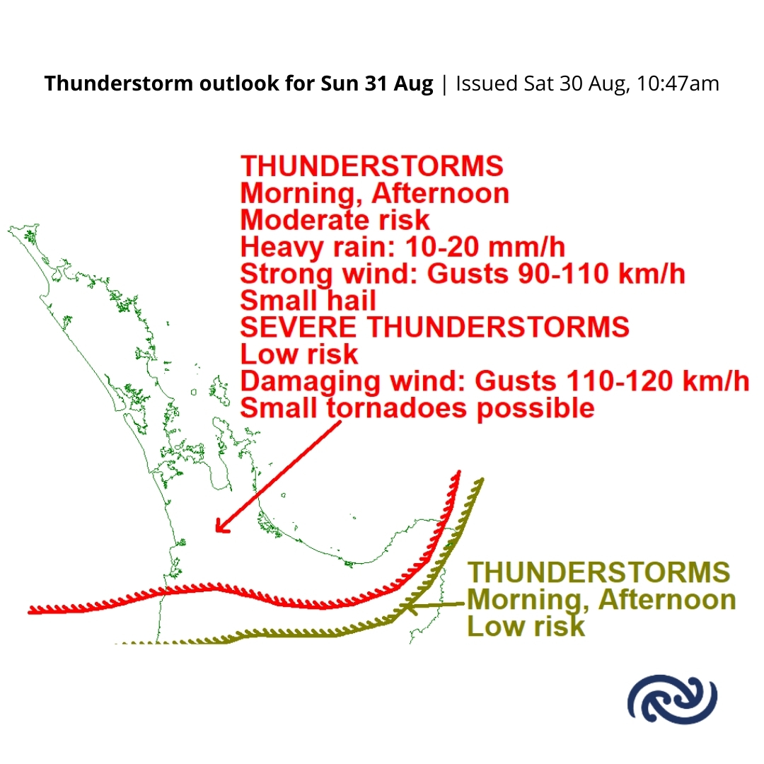
ALT Map of Aotearoa New Zealand from Taupō northwards. A title at the top of the page reads "Thunderstorm outlook for Sun 31 Aug Issued Sat 30 Aug, 10:47am". A red line marks an area from Waikato and Bay of Plenty northwards, with an arrow leading to a label saying "THUNDERSTORMS
Morning, Afternoon
Moderate risk
Heavy rain: 10-20 mm/h
Strong wind: Gusts 90-110 km/h
Small hail
SEVERE THUNDERSTORMS
Low risk
Damaging wind: Gusts 110-120 km/h
Small tornadoes possible". A brown line marks an area from Waitomo northwards, with an arrow leading to a label saying "THUNDERSTORMS
Morning, Afternoon
Low risk"
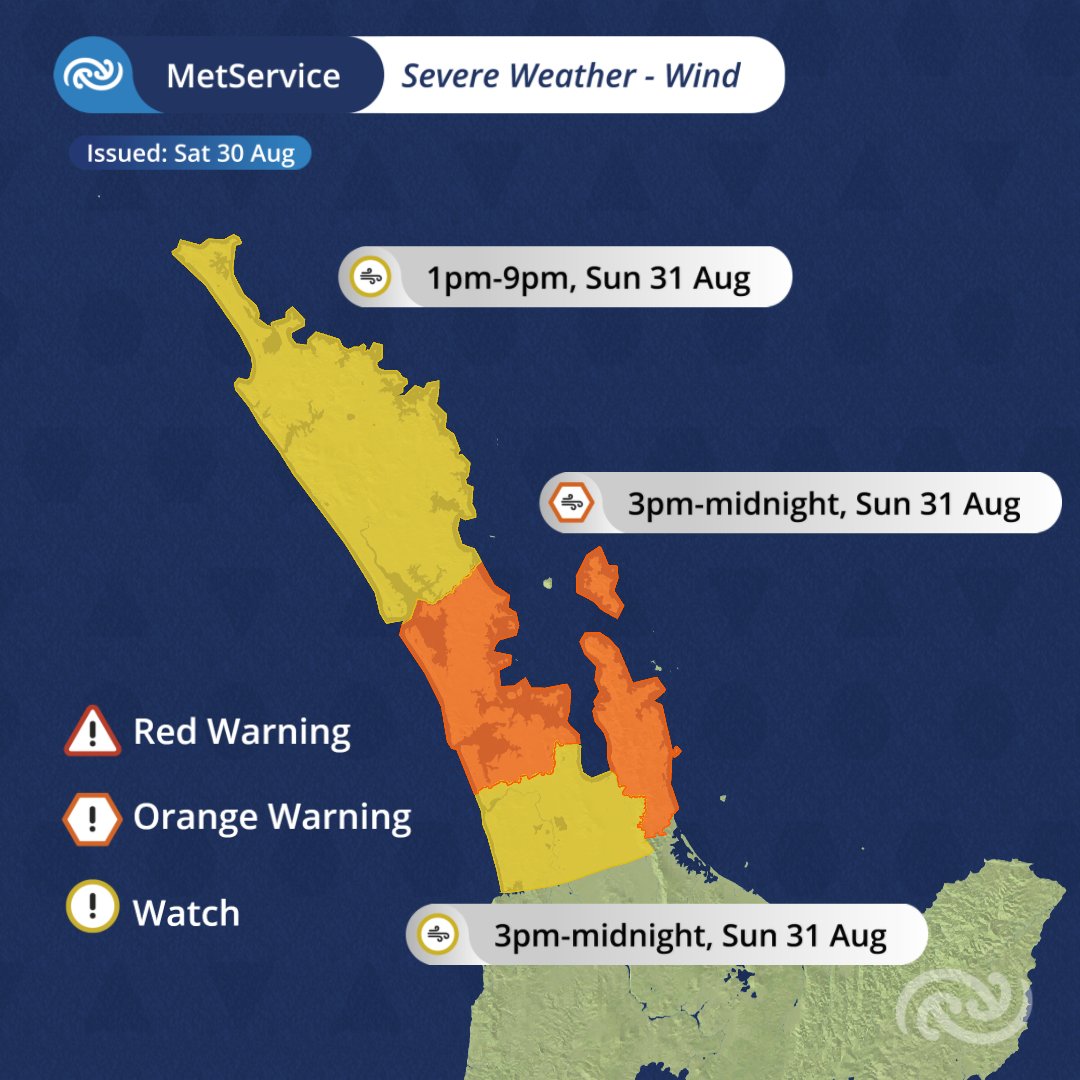
ALT Map of Aotearoa New Zealand from Taupō northwards. A label at the top of the image reads "MetService | Severe Weather - Wind | Issued: Sat 30 Aug". A legend to the left of the image shows a red triangle labelled "Red Warning", an orange hexagon labelled "Orange Warning", and a yellow circle labelled "Watch". Northland is highlighted yellow, with a nearby label showing a yellow circle with a wind icon in the centre, and the text "1pm-9pm, Sun 31 Aug". Auckland and Coromadel are highlighted orange, with a nearby label showing an orange hexagon with a wind icon in the centre, and the text "3pm-midnight, Sun 31 Aug". Waikato is highlighted yellow, with a nearby label showing a yellow circle with a wind icon in the centre, and the text "3pm-midnight, Sun 31 Aug".
**Unless there are significant developments, no further updates will be issued overnight**
A NEW TSUNAMI ACTIVITY NATIONAL ADVISORY has been issued following the earthquake near the East Coast of Kamchatka Russia.
Go to civildefence.govt.nz for more information.
We have issued another NATIONAL ADVISORY: TSUNAMI ACTIVITY following the M8.8 East Coast of Kamchatka Russia earthquake. Go to civildefence.govt.nz for more information.
Please see the latest update from @NZcivildefence. New Zealand remains under a national strong and unusual current threat.
This threat level is expected to remain until at least 3.00pm today Thursday 31 July.
We have issued another NATIONAL ADVISORY: TSUNAMI ACTIVITY following the M8.8 East Coast of Kamchatka Russia earthquake. Go to civildefence.govt.nz for updated information.
If you live aboard a vessel, please stay with friends and whānau tonight. If it is not an option, please visit our Civil Defence Centres (CDCs). Four CDCs are open for live-aboard boaties from 8.30pm until 7am on Thursday 31 July. More details: aucklandemergencymanagement.…
ALT Four Civil Defence Centres open for live-aboard residents
Update Thursday 31 July 8.50am | All Civil Defence Centres are now closed.
Reminder that tsunami advisory by @NZcivildefence is still in place for Auckland region.
(1/2)
- Stay away from beaches and out of the water until all warnings are lifted
- Evacuation onshore is not needed
- People in boats, live-aboards and at marinas should remain onshore, unless directed otherwise
(2/2)
Update 3.33pm | @NZcivildefence has advised that an earthquake near Russia has created tsunami activity.
❗️ We may expect strong and unusual currents and unpredictable surges at the shore from midnight tonight. (1/3)
✅ Stay away from beaches and out of the water until all warnings are lifted
✅ If you live aboard a vessel, please consider staying with friends and whānau tonight
(2/3)
✅ Stay updated with the latest, in case this advice changes. Follow @NZcivildefence and visit their website: civildefence.govt.nz/
👉 Share this information with family, neighbours and friends. Stay safe Auckland.
(3/3)
Update as at 12:42pm
The magnitude of the earthquake near Kamchatka, Russia has been re-assessed and upgraded to magnitude 8.7. In light of the new information, we are reassessing the tsunami threat to New Zealand.
Go to civildefence.govt.nz for more information.
Adam Maggs, General Manager Auckland Emergency Management shares the latest on today's severe weather. Heavier downpours expected later this afternoon.
Stay updated: metservice.com/warnings/home
Drive to the conditions. Do not drive through the floodwater.
🟠🟡Update to the Warnings and Watches
Auckland is now under an Orange Heavy Rain Warning, with very wet conditions expected for many on Tuesday. Keep an eye on the forecast over the next day or so to keep up with the latest information.
Slips, surface flooding, and rising rivers are all possible, especially during the day and evening. You may also encounter difficult driving conditions so stay safe!
Tuesday also brings a decent push of northerly and northeasterly winds, with Watches in place where they're expected to pack a punch
Head to bit.ly/AllWarnings for full details
Heavy rain and strong winds for Auckland today. MetService has issued Heavy Rain Warning (6am to 10pm Fri 11 July) and Strong Wind Watch (2pm to 9pm Fri 11 July) for Auckland.
Plan ahead for safe commute. Avoid low-lying areas.
ourauckland.aucklandcouncil.…
⚠️Risk of Downpours in the Severe Thunderstorm Watches⚠️
👀Two Severe Thunderstorm Watches have been issued with the risk of 25-40mm/hr in localised areas.
🔔Turn on those notifications in the MetService app to be notified of any Thunderstorm Warnings in your area.
bit.ly/AllWarnings@NRCexpress@AklCouncil@AucklandCDEM@BOPCivilDefence
‼️⚠️Severe Thunderstorm Warning has been issued for Auckland City and Franklin. These severe thunderstorms are moving towards the east, and are expected to lie near MARAETAI, CLEVEDON, WHITFORD and BROOKBY at 03:15 pm and near MARAETAI, CLEVEDON and KAWAKAWA BAY at 03:45 pm. These thunderstorms are expected to be accompanied by very heavy rain. @AucklandCDEM
🔗Find updates here: bit.ly/AllWarnings