
Extreme Weather Videographer, Storm Chaser, and Photographer. Video stringer for several news companies.
Joined April 2020
- Tweets 8,005
- Following 1,792
- Followers 18,352
- Likes 2,390
3,788 Photos and videos


Pinned Tweet

24 May 2024
The Most Impressive Multi-Vortex #TORNADO I have ever seen. The vortices were moving at warp speed. You must watch this! I was very close... I cropped in a bit to show you how intense this tornado was. #OKwx @NWSNorman
10
23
153
102,842
🌪️ Chase Success! Bagged a brief tornado today and now heading home. Time to shift focus to the next severe weather threats:
⚠️ Tuesday: Monitoring the potential for severe storms across Northeast Illinois, including the Chicago area.
⚠️ Wednesday: A potentially more significant severe weather setup may develop across Illinois, with the possibility of damaging winds, large hail, and tornadoes.
📡 Forecast details will become clearer over the next couple of days. Stay tuned for updates and live briefings!
#SevereWeather #IllinoisWeather #StormChasing #TornadoSeason #WeatherAlert #ChicagoWeather #MidwestWeather #StormForecast 🌩️🌪️
2
4
1,003
🌪️ Beefy wall cloud developing near Bern, Kansas! 🌪️
This storm continues to organize with a large, persistent wall cloud and increasing rotation. The environment across northeast Kansas remains favorable for supercells capable of producing tornadoes, large hail, and damaging winds. Anyone in the path of this storm should stay weather aware and be ready to take shelter if a warning is issued. ⚠️🌩️
📍 Bern, KS
📸 Monitoring closely for further strengthening and possible tornadogenesis.
#kswx #StormChasing #Tornado #WallCloud #Supercell #KansasWeather #SevereWeather #WeatherAlert 🌪️⚡📡
1
2
10
815
🌪️ Tight velocity couplet south of Bern and west of Berwick with strong inbound (blue) and outbound (red) winds very close together.
3
482
🌪️ Brief Rain-Wrapped Tornado Near Reserve, Kansas 🌧️
A weak, short-lived tornado was observed east of Reserve, Kansas earlier today, hidden within heavy rain and difficult to see due to being heavily rain-wrapped. 🌪️⚠️
📩 Contact: Curtislergner@gmail.com for licensing inquiries.
#KansasWeather #Tornado #RainWrappedTornado #StormChasing #SevereWeather #WeatherAlert #KansasStorms #MidwestWeather #StormReport #WeatherPhotography
1
5
27
2,104
@CBSNews @CNNweather @CNNweather @accuweather @breakingweather
@wxchanneldesk @wxchanneldesk @BanfieldonNN @NewsNation @NewsNationDesk @NewsNation_Desk
@abcnews @ABCNewsLive @CBSNews @CBSNewYork @NBCNewsWorld @NBCNews @NBCNewsNow @WeatherNation @weathernetwork @dailyherald @DailyMail @DailyMail @accuweather @breakingweather @cnnbrk @CNN @cnni @GMA @Ginger_Zee @Max_Gorden @Wx_Max @foxweather @FOXWeatherDesk @FoxWeatherNews @FoxNews @WXMolly @kellycass @JMichaelsNews @JacquiJerasTV
@KendallSmithWX @MichaelEstimeWX
554
1
9
638
Just had a brief tornado east of Reserve, KS! #KSwx
3
618
🌪️ Supercells Beginning to Fire! 🌪️
Thunderstorms are rapidly developing along the lifting outflow boundary near Fairview, KS and across northeast Kansas. These storms are expected to quickly organize into supercells over the next hour.
⚠️ Threats with any mature supercell:
🌪️ Tornadoes
🧊 Very large hail
💨 Damaging winds
The environment is becoming increasingly favorable for rotating storms, so areas across northeast Kansas and northwest Missouri should remain weather aware through this evening.
📡 We’ll be monitoring these storms closely for any signs of strengthening rotation or tornado development.
#KansasWeather #SevereWeather #Supercell #TornadoWatch #StormChasing #WeatherAlert #MidwestWeather 🌪️⛈️🧊
1
2
5
701
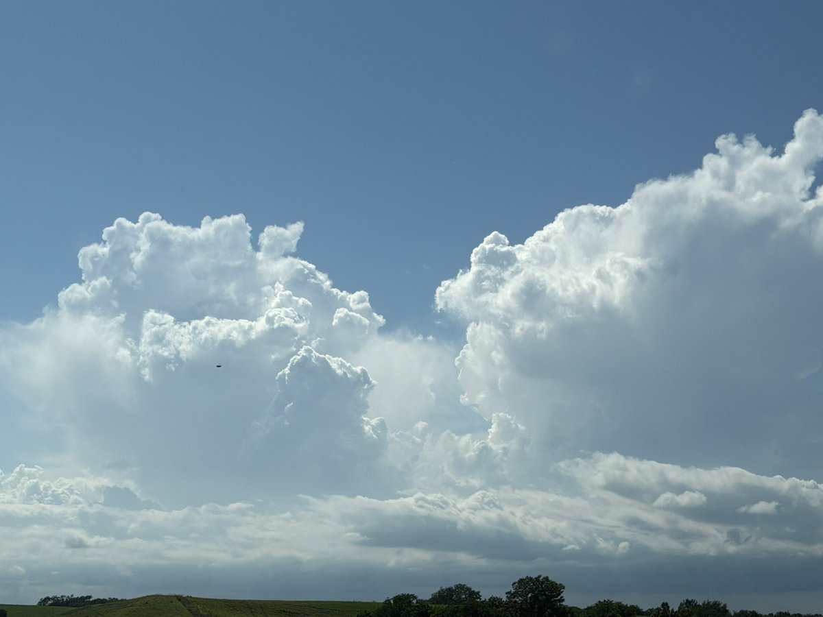
🌪️ Storms Are Starting to Fire! 🌪️
Towering cumulus clouds are rapidly developing along the lifting outflow boundary across Fairview, KS and northeast Kansas. This is a sign that the atmosphere is becoming increasingly unstable, and supercell development may not be far away.
⚠️ Any storms that can become established in this environment could quickly become severe with:
🌪️ Tornado potential
🧊 Large hail
💨 Damaging winds
We’ll be closely monitoring storm initiation over the next couple of hours as the severe weather threat continues to increase across the region.
#KansasWeather #SevereWeather #StormChasing #Supercell #Tornado #WeatherAlert #StormSeason #MidwestWeather 🌩️🌪️🧊

1
8
1,050
🌩️ Towers are rapidly going up along the lifting outflow boundary near Horton, KS and across northeast Kansas!
📈 The atmosphere is becoming increasingly unstable, and any storm that develops along this boundary could quickly become severe with the potential for:
🌪️ Tornadoes
🧊 Large hail
💨 Damaging winds
This area will need to be watched closely over the next few hours as storm initiation appears to be underway.
#KSwx #SevereWeather #StormChasing #Supercell #TornadoWatch #KansasWeather #WeatherAlert 🌪️⛈️

1
3
614
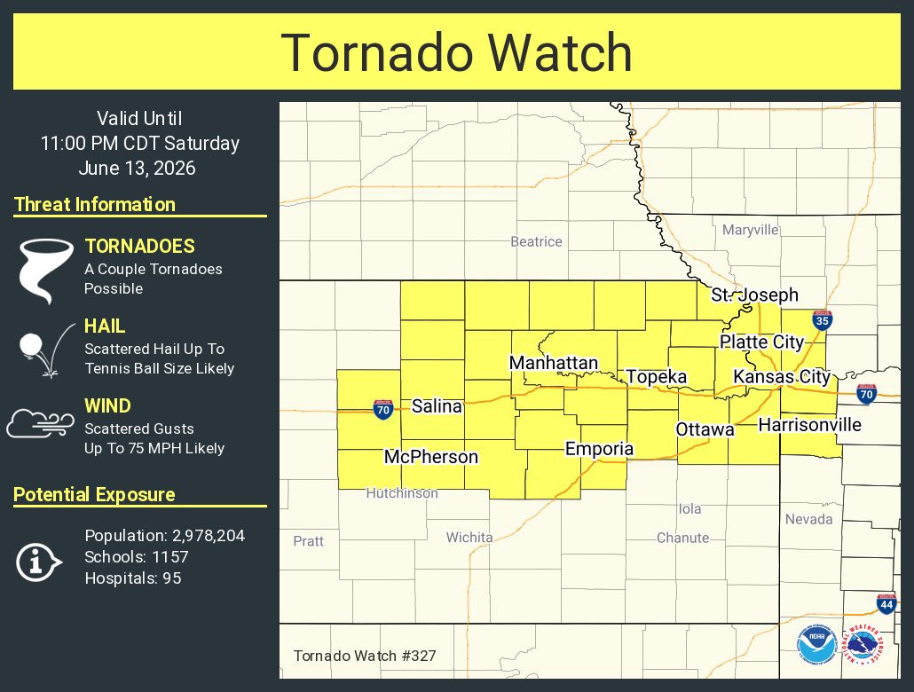
🌪️ TORNADO WATCH ISSUED 🌪️
A Tornado Watch has been issued for portions of Kansas and Missouri until 11 PM CDT.
⚠️ Conditions are favorable for severe thunderstorms capable of producing:
🌪️ Tornadoes
🧊 Large hail
💨 Damaging wind gusts
Supercells are expected to develop this afternoon and evening, with the potential for a few tornadoes and significant severe weather. Residents in the watch area should remain alert and be prepared to take shelter if warnings are issued.
📱 Stay weather aware and have multiple ways to receive warnings.
#TornadoWatch #KansasWeather #MissouriWeather #SevereWeather #StormChasing #WeatherAlert #Tornado #MidwestWeather 🌪️⛈️
5
509
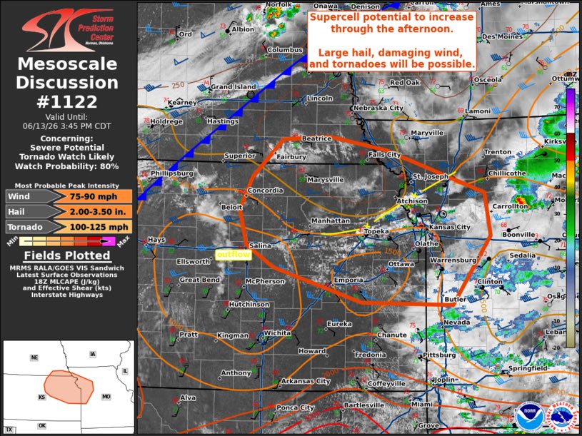
🌪️ Tornado Watch Likely This Afternoon Across Parts of KS, MO & SE NE 🌪️
⚠️ The SPC says conditions are becoming favorable for supercell thunderstorms across northeast Kansas, northwest Missouri, and far southeast Nebraska this afternoon.
🌩️ Main threats:
🧊 Large hail
💨 Damaging winds
🌪️ A few tornadoes, especially near lingering outflow boundaries
📈 Instability is rapidly increasing with strong moisture and favorable wind shear supporting rotating storms. Initial storms are expected to be discrete supercells, capable of producing all severe weather hazards.
➡️ Additional storms are expected to develop along a cold front later today and may organize into a larger complex, bringing a broader damaging wind threat eastward through the evening.
🚨 Residents across northeast KS, northwest MO, and southeast NE should stay weather aware and be prepared for watches and warnings later today.
#SevereWeather #TornadoWatch #KansasWeather #MissouriWeather #NebraskaWeather #StormChasing #Supercell #Tornado #WeatherAlert #MidwestWeather 🌪️⛈️🧊💨
3
529
🌩️ Today’s Target: Northwest Missouri / Kansas City Area 🌪️
I’m currently targeting northwest Missouri and areas near Kansas City for the potential development of isolated supercells capable of producing all severe weather hazards later today.
🌀 A lingering outflow boundary (OFB) left behind by an ongoing MCV (Mesoscale Convective Vortex) could become the focus for storm initiation this afternoon and evening.
⚠️ Potential Hazards:
🌪️ Tornadoes
🧊 Very Large Hail
💨 Damaging Winds
⚡ Frequent Lightning
The greatest concern will be any storm that can interact with the boundary, where low-level wind shear may be locally enhanced and support rotating supercells.
📡 We’ll be monitoring trends closely for where the atmosphere can recover behind the morning convection. If instability builds as expected, a few storms could become intense rather quickly.
#StormChasing #SevereWeather #Tornado #KansasCity #MissouriWeather #Supercell #StormForecast #WeatherAlert #MidwestWeather #StormSeason #ChicagoAndMidwestStormChasers 🌪️⛈️📡
1
1
4
755
🚨 LIVE SEVERE WEATHER BRIEFING TODAY 🚨 x.com/i/broadcasts/1vJpPPqam…
309
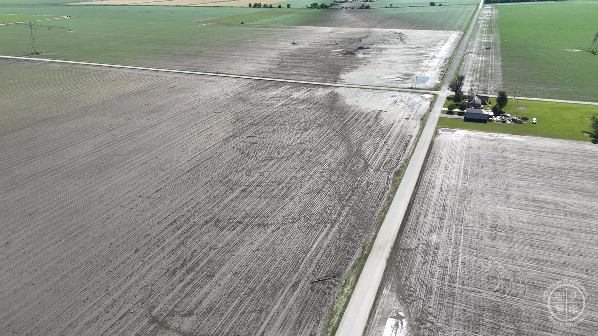
🌪️ Massive ground scouring from a violent tornado near Dwight, Illinois on 6/11/26.
The tornado carved through open fields before severely impacting the area, leaving behind intense damage and clear evidence of just how powerful this storm was. Our thoughts are with everyone affected.
📩 Contact: Curtislergner@gmail.com for licensing.
#DwightIL #IllinoisTornado #TornadoDamage #SevereWeather #StormChasing #Tornado #IllinoisWeather #MidwestWeather #ExtremeWeather #WeatherFootage #BreakingWeather 🌪️⚠️
8
45
2,585
Violent tornado damage near the northeast side of Kouts, Indiana on 6/11/26, where intense sub-vortices caused insane ground scouring along the tornado’s path. Truly extreme damage indicators from this destructive storm. 🌪️🚨
📩 For licensing: Curtislergner@gmail.com
#IndianaTornado #KoutsIndiana #TornadoDamage #StormDamage #SevereWeather #TornadoOutbreak #GroundScouring #SubVortices #INwx #MidwestWeather #StormChasing #ExtremeWeather
1
4
17
1,676
Violent tornado damage near the northeast side of Kouts, Indiana on 6/11/26, where intense sub-vortices caused insane ground scouring along the tornado’s path. Truly extreme damage indicators from this destructive storm. 🌪️🚨
📩 For licensing: Curtislergner@gmail.com
#IndianaTornado #KoutsIndiana #TornadoDamage #StormDamage #SevereWeather #TornadoOutbreak #GroundScouring #SubVortices #INwx #MidwestWeather #StormChasing #ExtremeWeather
3
12
1,248
NE of Kouts, Indiana, a violent tornado caused extreme damage — shredding and collapsing four high-voltage transmission towers, with major ground scouring, debris scattered everywhere, and a nearby home showing signs of a direct hit. This was a powerful and destructive tornado. 🌪️⚡🏚️
📩 Contact Curtislergner@gmail.com for licensing.
#IndianaTornado #KoutsIN #TornadoDamage #SevereWeather #StormChasing #ViolentTornado #TornadoOutbreak #WeatherVideo #BreakingWeather #MidwestWeather
1
21
76
5,912
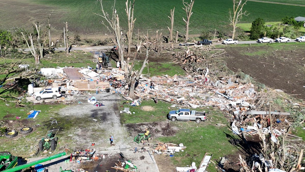
🌪️ Devastating tornado damage northeast of Kouts, Indiana. A home was completely wiped off its foundation, with debris scattered everywhere as several people searched through the wreckage for belongings. This was a violent tornado.
📩 Contact Curtislergner@gmail.com for licensing.
#IndianaTornado #KoutsIndiana #TornadoDamage #SevereWeather #StormDamage #MidwestWeather #BreakingWeather #Tornado #Weather #StormChaser 🌪️🏚️🙏


3
16
78
3,613
🌪️ Devastating tornado damage northeast of Kouts, Indiana. A home was completely wiped off its foundation, with debris scattered everywhere as several people searched through the wreckage for belongings. This was a violent tornado.
📩 Contact Curtislergner@gmail.com for licensing.
#IndianaTornado #KoutsIndiana #TornadoDamage #SevereWeather #StormDamage #MidwestWeather #BreakingWeather #Tornado #Weather #StormChaser 🌪️🏚️🙏
1
23
68
4,727