
Former Head Coach @ Northeast High School Special Needs Teacher/Advocate Miami Hurricanes, Orlando Magic, Tampa Bay Rays, Dallas Cowboys (I know lol)
Joined May 2022
- Tweets 383
- Following 247
- Followers 130
- Likes 2,432
45 Photos and videos


Jun 8
Mickey was the best and is a legend in Pinellas County and beyond. If you ever played for or against us at The East, Mickey was gonna make sure you were taken care of with the utmost love and respect. Sad day today 💔
1
3
8
356
Tyler Baynard retweeted

Jan 16
The nation hates Miami again. Order has been restored.
40
326
2,289
45,287
Tyler Baynard retweeted

11 Nov 2025
DESMOND BANE INSANE GAME-WINNER!!! 😱🤯
159
1,390
17,923
609,204


Tyler Baynard retweeted

31 Jan 2025
My son is autistic and non verbal but when he’s hungry he comes in the living room and (on his iPad) plays the part on lion king where the hyena tells scar “it’s dinner time and we ain’t got no stinking entrees” 😂😂 This dude (and every other autistic person in the world) is so much smarter than any of us will ever understand.
686
6,045
72,027
2,995,156
Tyler Baynard retweeted

20 Jan 2025
bringing this back because it feels like it’s time
the new york times bestselling book A DIFFICULT CONVERSATION — How To Talk To Trump Supporters
“essential and timely and important” — @washingtonpost
available today only as a free download
🔗: sheaserrano.gumroad.com/l/ak…

24
225
1,644
75,054
Tyler Baynard retweeted

18 Jan 2025

6
9
949
Tyler Baynard retweeted
19 Jan 2025
Live Footage of the epic game from @NoahRod25 ! College coaches if your program is looking for a shooter look no further!! @TheUncommitted0 @SPCMBasketball @PinellasHSMedia @Biggamebobby @LakelandCCMBB @HCCFL_MBB @CoachWingreen
1
3
7
1,175
Tyler Baynard retweeted
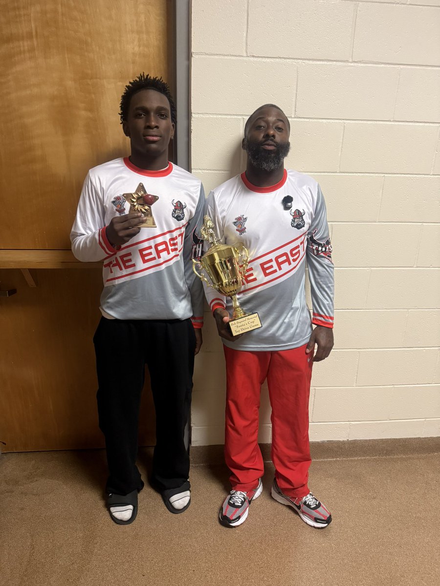
14 Dec 2024
After A 4 Game Skid The Hobbled Vikings Were Able To Have A Big Win Last Night Vs Shorecrest Lead By Sophomore Guard @2shiftywalter 18pts 5rebs 5ast 2stls . He Finshed As MVP as Northeast Won The Santa Cup 🏆.@CoachT727 @tampaball @Biggamebobby @AbsolutelyKfish
9
9
1,963
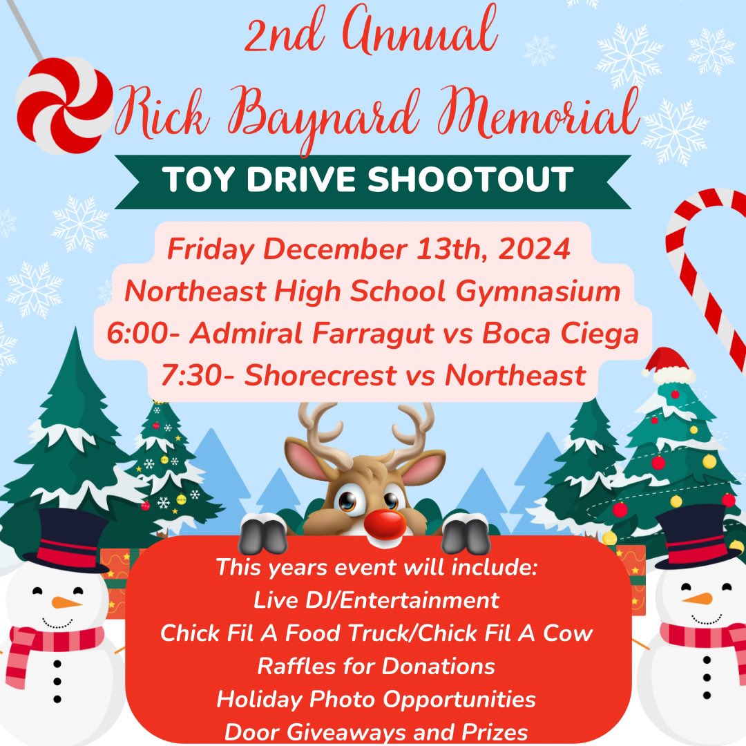
13 Dec 2024
@FOX13News @BN9 @abcactionnews @TB_Times
2nd annual of my Father’s namesake memorial event but 7th year total for the event. We would love if you wanted to come out and cover! 😇🖤
1
3
2
561
26 Nov 2024
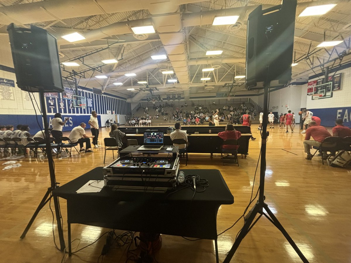
Had a great time DJing at the 2024 Battle at the Lake @ELHS_Basketball tonight. @Cside_hoops vs @BocaCiega_Hoops was a wild double overtime game. Looking forward to seeing what tomorrow’s games look like. Coaches if you need a DJ for a big game hmu!!
5
8
492


17 Oct 2024
Flamed their dumb asses 😂😂😂

Kamala Harris: Oh, you guys are at the wrong rally. I think you meant to go to the smaller one down the street
1
140
13 Oct 2024
When Miami is all the way back lol

1
116
Tyler Baynard retweeted

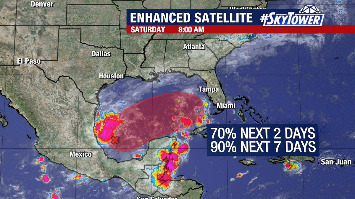
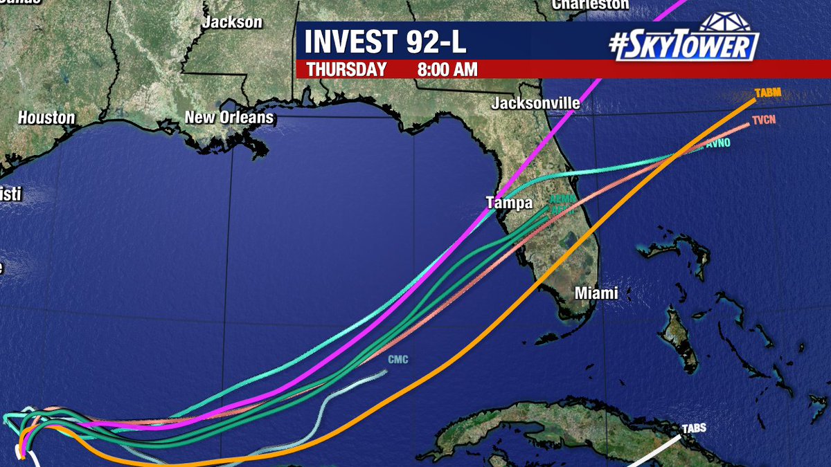
5 Oct 2024
Not what we want to be reading first thing Saturday morning, but here we are.
Judging by satellite imagery this morning, INVEST 92L looks healthy on satellite. I would not be surprised to see advisories issued soon on what will eventually be "Milton".
Here's the bottom line:
In all likelihood we will have a #hurricane in the Gulf in a few days. It will be moving in a direction that is rare. There are not many storms that start in the Bay of Campeche and then move towards Florida. If they do, they are almost alway sloppy hybrid systems, not well defined hurricanes. So, it's a little surprising that most models are aggressive. Some have a hurricane near us by Tuesday night/Wednesday morning. Hopefully, at some point we will say. "See, there's a reason storms don't do what this one was forecasted to do" We can hope.
It is still a few days away, and I expect there will be track and intensity adjustments. There always are. This is a completely different set-up than Helene. This storm will probably hit the state straight on. That changes the storm surge part of the forecast. Storm surge in this case would happen pretty much at the point of landfall and to the south of landfall. There would be minimal storm surge north of the point of landfall, but there would be a lot of rain and wind. Thus, where (assuming it does) makes landfall will determine who will have surge concerns. So, even a 5 mile difference in landfall matters. OK, so where is it going to make landfall? There is still lots of spread. It seems that #Tampa Bay to Collier County in SWFL makes the most sense and is supported by the models. That is a large area, with a lot of population. We will start narrowing the potential landfall point in the next day or two.
Debby and Helene did impact our inland areas, but by far, most of the impacts were near the coast. Instead of paralleling the state, this storm will likely move across the state and will bring its strong winds and heavy rain inland.
I know many of you are still in the midst of getting your life back together from Helene. This is the last thing you want to deal with. I (and my team) will do our very best to get through this together. Plan on some changes and adjustments with this one. While intensity is certainly important, the exact track will be critical to determining who receives not much, who receives rain and wind, and who receives a storm surge threat.
50
218
1,045
189,264
Tyler Baynard retweeted

29 Sep 2024
Checking in on Preseason #10 Florida State
538
1,659
45,664
3,854,560