
Product Leader building tools for managing and processing large spatial data sets | Father of 2 | Hiker | Camper
Joined February 2009
- Tweets 278
- Following 559
- Followers 201
- Likes 86
99 Photos and videos


Pinned Tweet

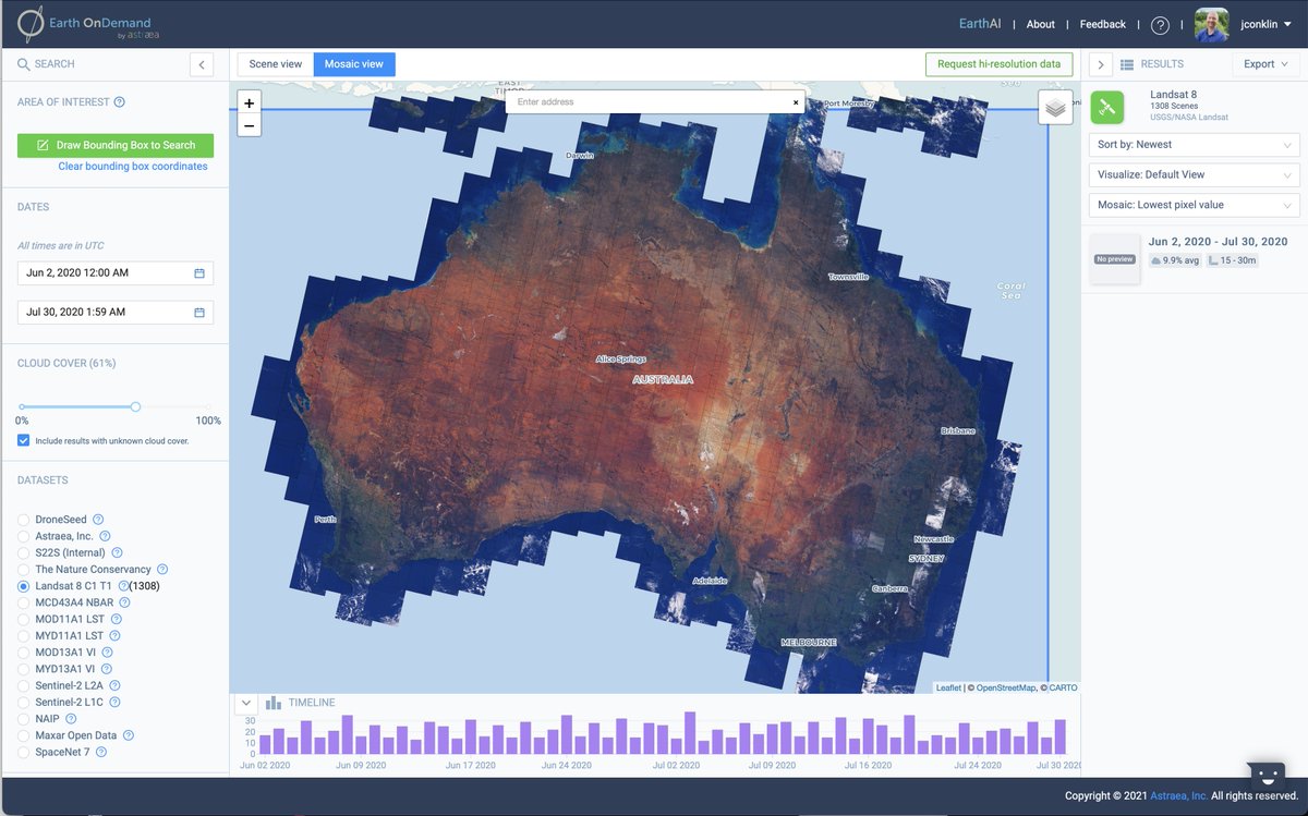
9 Dec 2020
@AstraeaInc adds more false-color composite and index views to Earth OnDemand!
loom.ly/4buvycI
#SatelliteImagery #EarthObservation #Landsat #sentinel #MODIS #NAIP #Analytics
1
1
19 Apr 2023
The advanced monitoring capabilities that are enabled by Planet’s tasking combined with Astræa’s spatiotemporal platform enable highly detailed monitoring applications related to elevating market intelligence in the renewable energy, commodity trading,... businesswire.com/news/home/2…
52
Jamie Conklin retweeted

23 Mar 2023
The 26 hottest proptech startups of 2023, according to venture capitalists trib.al/aM4pVS5
2
3
7
21,219
20 Sep 2022
Why is Satellite Imagery important in Industrial Real Estate?
I'd love to know what you think.
Here are my thoughts:
link.medium.com/LEhsfwVLttb
1
Jamie Conklin retweeted

10 Mar 2022
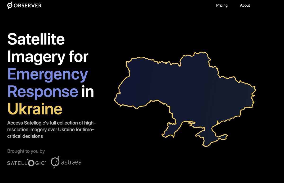
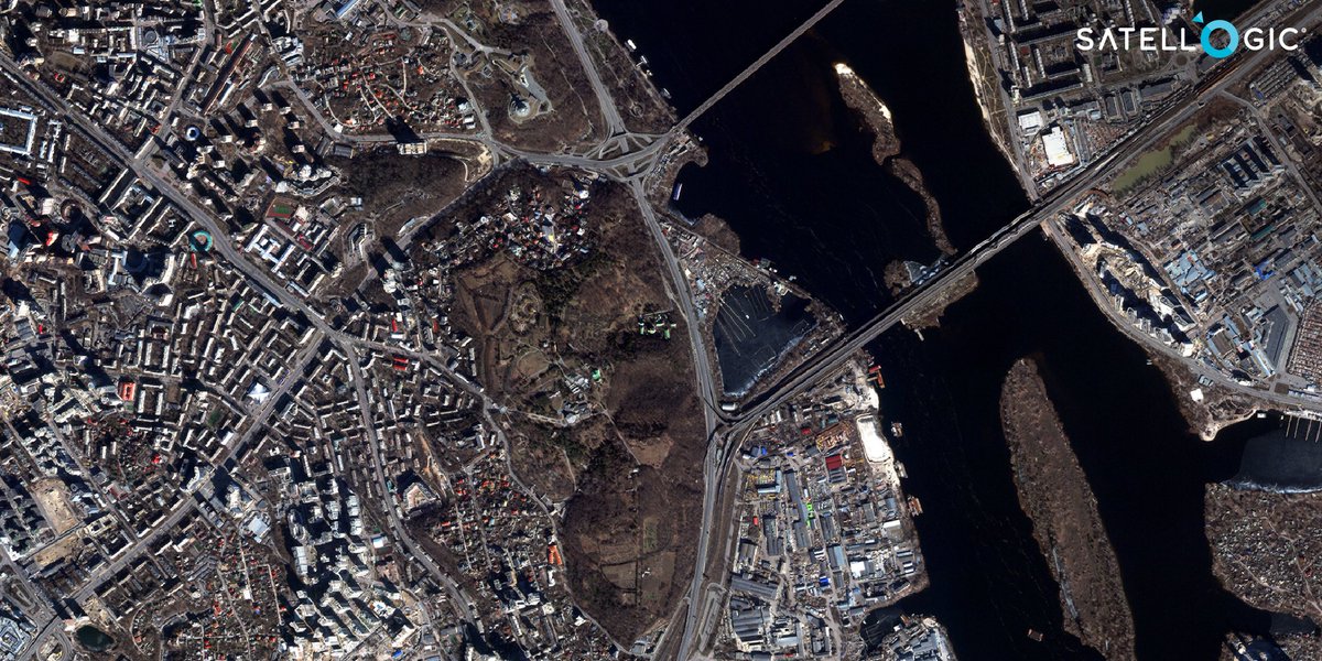
This is pretty awesome - @AstraeaInc and @Satellogic just launched a collaboration so that organizations needing access to timely satellite data over Ukraine get both imagery and tooling to exploit it bundled together: ukraineobserver.earth/
1
36
95
Jamie Conklin retweeted

8 Mar 2022
Today we announced the release of our Daily Collection Access program for emergency response in #Ukraine. In collaboration with @AstraeaInc collections will be made available to approved humanitarian and non-governmental organizations. Read more: bit.ly/3MC0Y2a
6
46
137
Jamie Conklin retweeted

8 Mar 2022
Supporting #Ukraine is a personal mission for us. Collaborating with @Satellogic allows us to combine the latest high-resolution imagery with our user-friendly EarthAI platform, helping those making a difference in the face of crisis
ukraineobserver.earth
#StandWithUkraine 🇺🇦🛰️
8 Mar 2022

Today we announced the release of our Daily Collection Access program for emergency response in #Ukraine. In collaboration with @AstraeaInc collections will be made available to approved humanitarian and non-governmental organizations. Read more: bit.ly/3MC0Y2a
2
10
39
Jamie Conklin retweeted
20 Oct 2021
Check out our VP of Product, Jamie Conklin (@Conkshell) as he talks to @Labellerr1 about his experiences at Astraea developing tools to support #GeoAI!
youtu.be/X1_CnBc8Ri8
#AI #Geospatial #GeospatialData #DataScience

2
1
20 Oct 2021
Now it is cheaper to task #SatelliteImagery than it is to hop in your car to visit a site.
What does that mean for your business?
medium.com/astraeaearth/task…
1
22 Jun 2021
How do you find a cement plant? In our work with @FinanceSpatial and @SatAppsCatapult we found hundreds. Check out this article to learn more!
22 Jun 2021

Read about our project with the Spatial Finance Initiative using #SatelliteImagery to identify cement plants in under-reported regions of the world! 🌏
medium.com/astraeaearth/spat…
@FinanceSpatial @SatAppsCatapult @AlanTuringInsti @GFI_green #SustainableFinance #GeoAI #ClimateChange
2
Jamie Conklin retweeted
22 Jun 2021
Read about our project with the Spatial Finance Initiative using #SatelliteImagery to identify cement plants in under-reported regions of the world! 🌏
medium.com/astraeaearth/spat…
@FinanceSpatial @SatAppsCatapult @AlanTuringInsti @GFI_green #SustainableFinance #GeoAI #ClimateChange
6
6
27 May 2021
Where the water goes... This website shows how a drop of rain will flow to the ocean with a slick interface! #watershed
loom.ly/xad0Ak8
1
Jamie Conklin retweeted
3 May 2021
Fusing #geospatial and #location data intelligence!
@Cuebiq #LocationData #SatelliteImagery #GeoAI #EarthObservation
newswire.com/news/astraea-an…
2
5 Apr 2021
I saw a fascinating video from the @wef (loom.ly/CMP3hn8) about the Great Green Wall so I created a mosaic image of #Sentinel2 imagery to see it.
Try for yourself:
loom.ly/um2Skxg
#SatelliteImagery #EarthObservation #sentinel2 #Analytics @astraea
1
25 Mar 2021
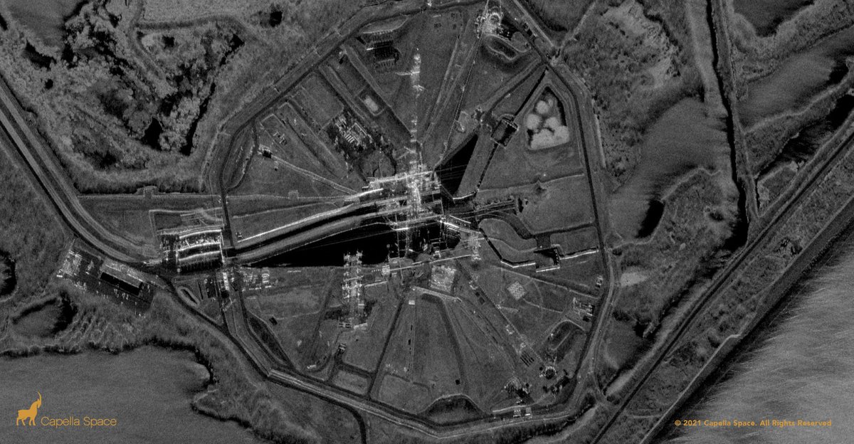
This is what being stuck in the muck looks like in #SAR!
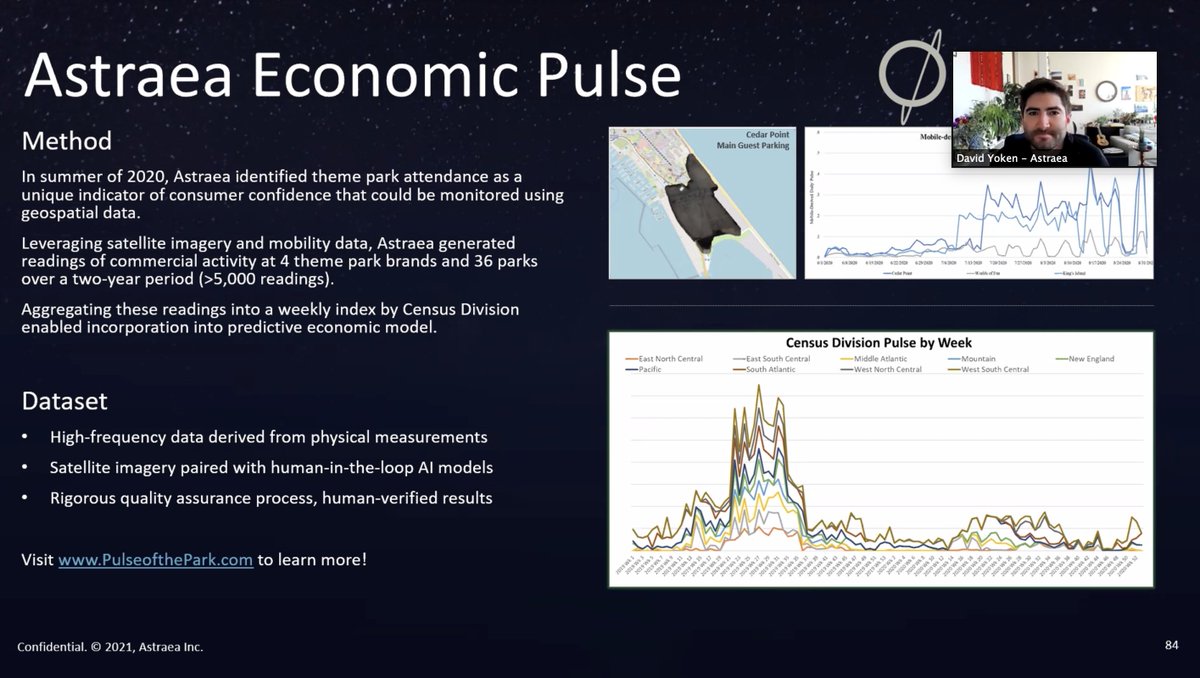
Monitor economic activities with EarthAI Pulse! Rain or shine data from @capellaspace is available from @AstraeaInc!
1
2
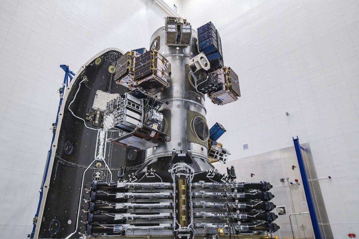
19 Mar 2021
Cool video of our partner @capellaspace deploying their #SAR antenna!
#SatelliteImagery #EarthObservation @AstraeaInc
3
24 Feb 2021
A few weeks ago I spent some time to reflect on lessons I've learned in my career as a #productmanager and how it applies to me now. This is what came out... medium.com/astraeaearth/we-n…
1
Jamie Conklin retweeted
24 Feb 2021
Fantastic & insightful presentations from all teams at today's #Data #Hackathon hosted by @DollarEagle. Thank you for including us. Team Quant Gurus FTW!
#DataAnalytics #Geospatial #AlternativeData #EarthObservation #AI #ML
@CausalityLink @Thinknum @Apptopia @facteus @Zondahome
5
7
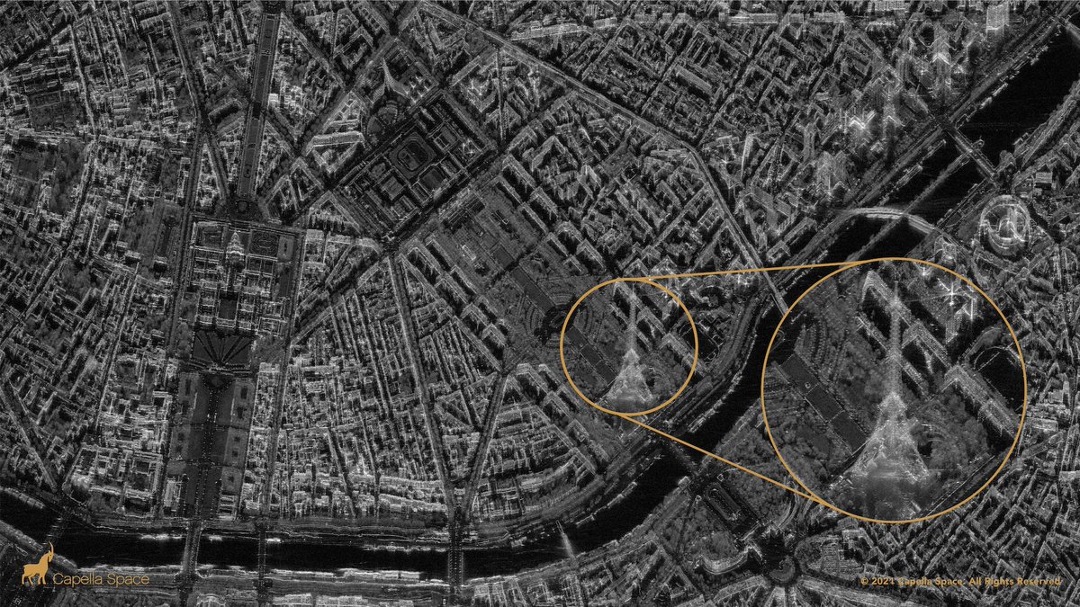
24 Feb 2021
What's hiding behind the clouds in your #SatelliteImagery?
#SAR can see through clouds and is ideal for #monitoring applications. @AstraeaInc can help set up a feed from @capellaspace and #ChangeDetection #Analytics for you.
loom.ly/J2KGCT0