
Passionate about weather, weather forecasting and climate change.
Joined September 2021
- Tweets 2,082
- Following 224
- Followers 430
- Likes 97
1,332 Photos and videos
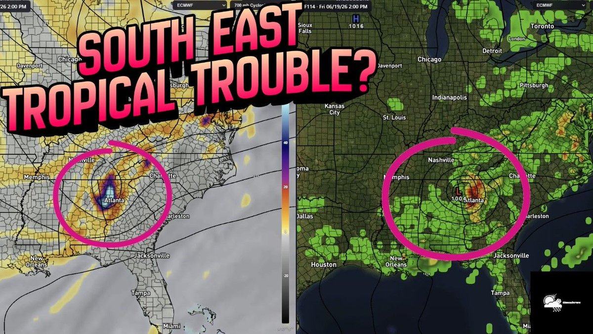


🚨 Tropical Update: Is the European model onto something, or is it a major outlier? 🌀 I’m breaking down the latest model disagreement for the Gulf Coast and what it means for your week.
Plus, we’re looking at a serious rainfall & flooding threat for the Southeast. 🌧️
Watch the full analysis: youtu.be/BPZiC_83uHc
#TropicalUpdate #HurricaneSeason #WeatherAnalysis #GulfCoast
Check out the full breakdown here: youtu.be/BPZiC_83uHc
#WeatherForecast #TropicalUpdate #FloodWatch #TimEalerwx
6
349
Meteorologist Tim Ealer retweeted

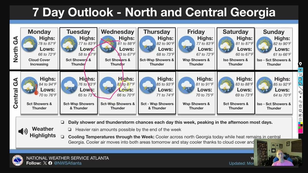
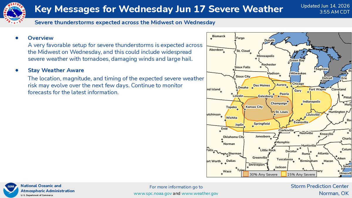
Here are our Key Messages for Wednesday (6/17).
3
50
247
21,448
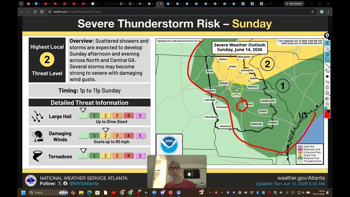
🚨 ATTENTION GEORGIA: We have a window for severe weather today between 1:00 PM and 6:00 PM. The main threat is gusty winds up to 60 mph, specifically for areas south of Atlanta and into Central/Eastern Georgia. 🌩️
On top of the storms, we are looking at 100° heat indices for the southern half of the state. I’ve got the full breakdown of the timing and which areas are at the highest risk in today's update.
Stay weather-aware and watch here: Georgia Residents: youtu.be/M6dH_IlGTKI
80
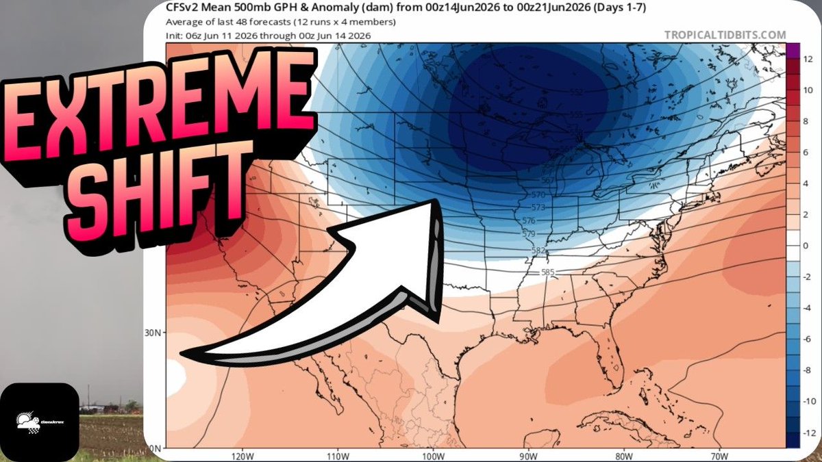
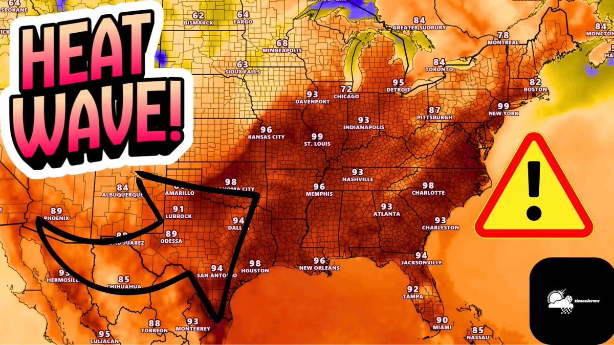
X (formerly Twitter) / Facebook Post: 🚨 EXTREME WEATHER SHIFT: From 110° heat indices to a Level 3 severe weather risk in the Midwest, the next 2 weeks are looking active. ⛈️🌡️ I’m breaking down the moisture surge in the South and where the biggest flood risks are setting up.
Watch the full forecast here: youtu.be/-W4GYv-7_VI
#SevereWeather #WeatherForecast #HeatWave
518
Meteorologist Tim Ealer retweeted
7:55am CDT #SPC Day1 Outlook Enhanced Risk: across portions of the central Plains and Lower Missouri Valley spc.noaa.gov/products/outloo…

51
201
18,230
Meteorologist Tim Ealer retweeted
12:38pm CDT #SPC Day2 Outlook Slight Risk: from northern Georgia northward into portions of southern New England spc.noaa.gov/products/outloo…

40
139
16,197
Yep . For sure but It only takes one. Andrew is a good example. Appreciate you brother
Jun 13

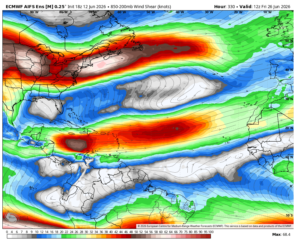
Interrupt your weekend scroll on X to remind you it's going to be a far fewer than normal hurricane season in the Atlantic.
Wind shear is blasting the Caribbean and deeper tropics already and should do so through a good chunk of the season. This is the last week of June on the AI Euro. Only spot with lighter shear may be over the Gulf.
Developing very strong to record El Nino is going to blast the MDR with wind shear for the next few months.
1
142
🚨 SEVERE WEATHER ALERT: A dangerous setup is unfolding across the Central Plains & Midwest today.
🌪️ Tornado Risk: EF2 possible (7-8 PM Central) near KC & St. Joseph. 💨 Wind: 60-75 mph gusts expected. 🌊 Flash Flooding: Moderate Risk near Springfield, MO.
Don't be caught off guard. Full breakdown of timing and storm modes here: youtu.be/eyW-QpUEXrI
#MOwx #KSwx #IAwx #Tornado #StormWatch #TimEalerwx
99
Meteorologist Tim Ealer retweeted

Jun 12
Our area of interest now has a 20% chance of developing. The chance is still low, but the area of disturbed weather is showing up well in the Southern Gulf.

6
38
2,092
A 30 percent risk of Severe Weather is in Store for the Mid Atlantic States Later Today.
38
Meteorologist Tim Ealer retweeted
Jun 12
Sheesh

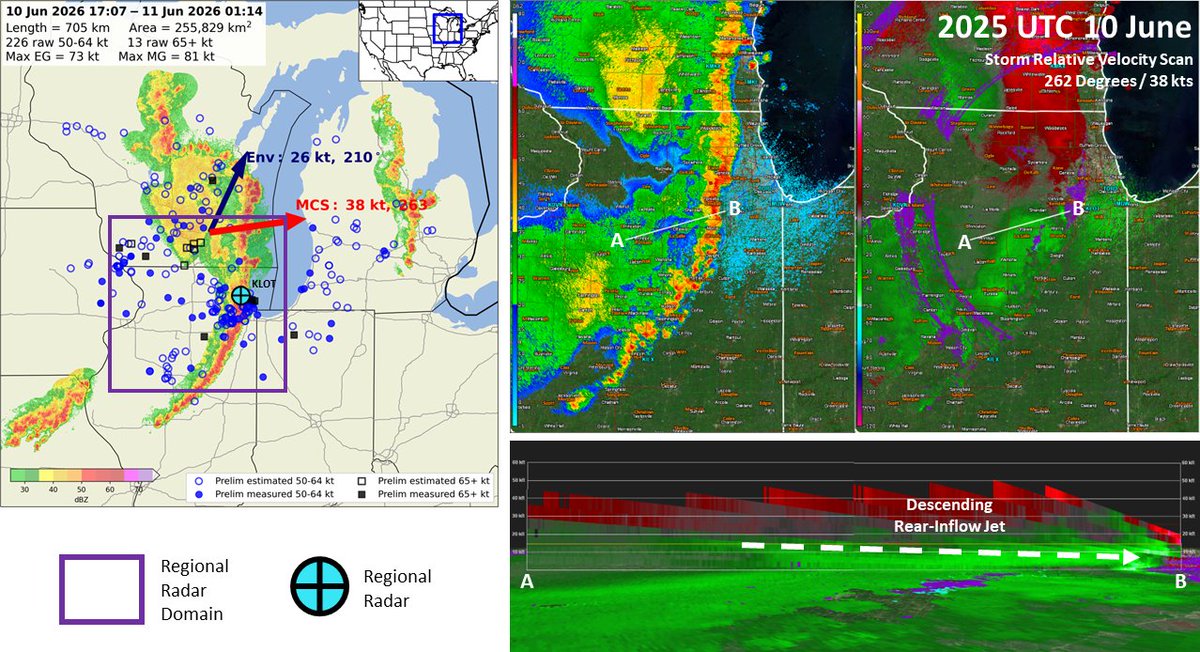
The damaging wind swath from Wednesday, June 10 has been preliminarily confirmed as a derecho.
The wind swath had a track length over 400 miles with a footprint just under 100,000 square miles. The strongest known gust was measured at over 94 mph.
1
20
4,136
The severe weather pattern isn't letting up! ⛈️ Today we’re watching a significant wind risk for the Eastern Seaboard and a developing system out West. After a week with over 50 tornadoes, it’s important to stay weather-aware. Check out the latest timing and radar analysis here. Stay safe! 🌪️ youtu.be/vlFKipbk9H8 #SevereWeather #WeatherUpdate #StaySafe #StormChasing
3
8
1,290
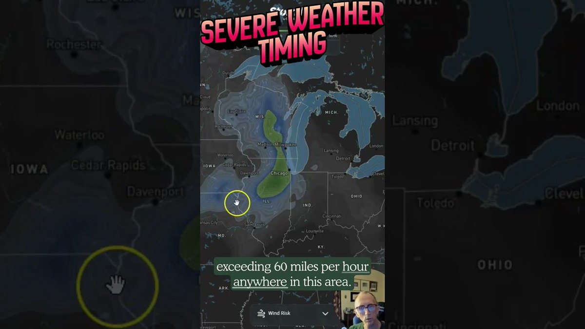
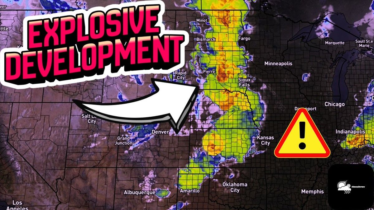
⚠️ SEVERE OUTBREAK ALERT: Today is a significant severe weather day for the Midwest.
My latest analysis is showing a major tornado and hurricane-force wind threat (45% probability) for the Chicago/Davenport corridor, peaking between 3PM–8PM.
Full technical breakdown: youtu.be/RHVo_nxNlCw
#SevereWeather #TornadoThreat #WindRisk #ChicagoWX #TimEalerWX
1
1
249
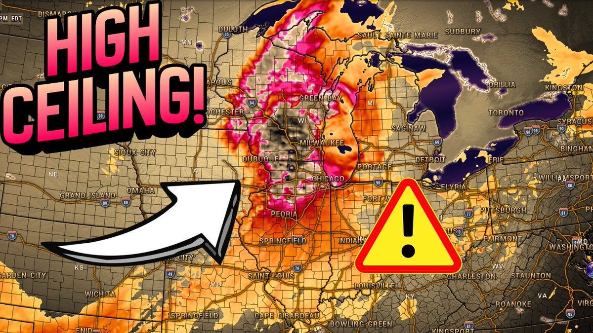
🚨 SEVERE OUTBREAK ALERT: Meteorological guidance shows a significant threat today. We are looking at a 45% chance of hurricane-force winds (Chicago to Des Moines) and a 10% risk of EF2-capable tornadoes.
A Quick Break Down of the Threats Here: youtube.com/shorts/v3nuemxxM…
#SevereWeather #TornadoRisk #WindThreat #TimEalerWX
42
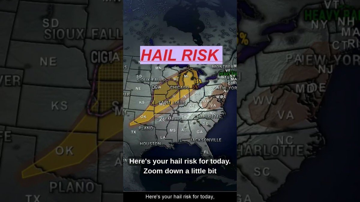
⚠️ ENHANCED SEVERE THREAT: Multiple rounds of storms are expected today across the Upper Midwest and Missouri Valley. We are tracking 75 mph wind, 2-inch hail, and tornado potential (EF2 possible).
Get the full timing breakdown here: youtu.be/gJtc9lNHqsE
#SevereWeather #EnhancedRisk #WeatherAlert #Meteorology #TimEalerWX
39
⚠️ HEAT WAVE UPDATE: We are looking at dangerous, early-season heat gripping the US East of the Rockies. I’m breaking down the heat index projections and why the lack of overnight cooling makes this event particularly hazardous.
Stay safe & check the forecast: youtu.be/QhHwNQqIOkE
#HeatWave #ExtremeHeat #WeatherAlert #Meteorology #TimEalerWX
1
63