
Joined October 2010
- Tweets 1,694
- Following 889
- Followers 293
- Likes 1,034
186 Photos and videos


Jun 11
اصدار اول من GeoLibre
من قبل @giswqs
منصة GIS مفتوحة المصدر، خفيفة، تعمل في المتصفح، سطح المكتب، الجوال، وJupyter.
بدون حساب، سيرفر، أو تكلفة. بياناتك تبقى خاصة.
..
viewer.geolibre.app
Jun 11

GeoLibre v1.1 is out!
GeoLibre is a free and open-source, lightweight, cloud-native GIS platform for visualizing, exploring, and analyzing geospatial data. One application that runs everywhere: in your web browser, as a native desktop app, on your phone, and inside a Jupyter notebook. No account, no server, no cost. Everything runs locally and your data stays private.
This release builds on the v1.0 foundation with features that make day-to-day mapping smoother:
- Attribute table management — rename, delete, hide/show, and reorder fields right in the table, with the layout saved to your project.
- Data-driven symbology for Add Vector Layer — single, categorized, graduated, and expression-based styling now applies to maplibre-gl-vector layers.
- Atmosphere Effects plugin — a deep-space backdrop, parallax starfield, comets, and a glowing globe halo at low zoom (toggle it from the Controls menu).
- Layer panel upgrades — rename layers, open the attribute table, and export straight from the layer actions menu.
- Auto Refresh extended to Add Vector Layer URL layers.
- In-browser GeoPandas via Pyodide — run the vector tools with no Python sidecar, same results.
- Plugin API — external plugins can now render on the host's shared deck.gl instance via app.getDeckGL().
Try the live demo: viewer.geolibre.app
Star it on GitHub: github.com/opengeos/GeoLibre
Docs and roadmap: geolibre.app
Release notes: github.com/opengeos/GeoLibre…
#GIS #OpenSource #Geospatial #MapLibre #WebGIS #DuckDB #GeoLibre
51
Fadi chaaban retweeted

May 15
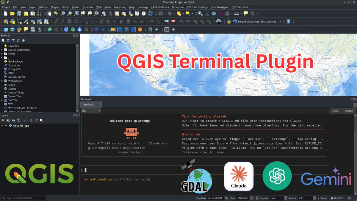
Introducing QGIS Terminal Plugin: An Integrated Terminal for QGIS
Discover the new QGIS Terminal Plugin that lets you run terminal commands directly inside QGIS , no more switching between your GIS desktop and external terminals. In this tutorial, you'll learn how to install the plugin, customize the integrated terminal, manage multiple tabs, and run tools like Claude Code, Codex, Conda environments, and standard Linux commands right inside QGIS.
GitHub: github.com/opengeos/qgis-ter…
Video tutorial: youtu.be/iL-RtdGh-d8
#QGIS #geospatial #opensource
33
165
7,084
#مقالة_علمية جديدة our new #article
Modeling the Spatial Impact of Topography on Land Cover Map Accuracy: A Spatial Statistical Analysis of the ESA WorldCover 2
link.springer.com/article/10…
8
Fadi chaaban retweeted

Apr 18
من أفضل الحلول للبقاء على اطلاع دائم على الأوراق العلمية.
في الفترة الاخيرة وظفت ادوات الذكاء الصناعي لمساعدتي على قراءة وتلخيص الأوراق العلمية.
اتبعت أوامر prompts معينة ساعدتني في زيادة إنتاجيتي في قراءة عدد الأوراق العلمية في وقت قصير.
قرأت هذا المقال من نيتشر ومنه تعلمت الطريقة.
FOCUS: an AI-assisted reading workflow for information overload: Career feature
nature.com/articles/s41587-0…
4
70
446
25,566
Fadi chaaban retweeted

Mar 2
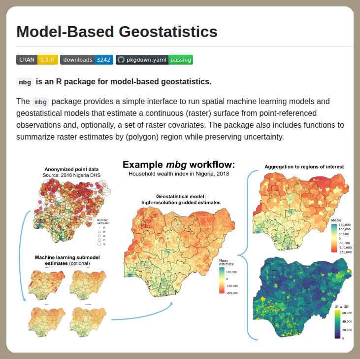
Estimates surfaces from point observations
github.com/henryspatialanaly…
35
207
9,677
Fadi chaaban retweeted

Feb 23
The 2026 Esri Young Scholar Awards are officially open. Showcase your GIS projects, spatial storytelling, and real-world impact on a global stage. Submit your application here: hubs.li/Q0447Nk-0

1
6
19
548
Fadi chaaban retweeted

🔥 أدوات ذكاء اصطناعي سرية 2026 ( الجزء الثاني ) :
1ـ Levity.ai – روبوت لأتمتة المهام
2ـ Jasper.ai – كاتب محتوى
3ـ Gamma.app – إنشاء عروض بوربوينت
4ـ Magiceraser.io – إزالة العناصر الزائدة
5ـ Socratic.org – حل الواجبات المنزلية
6ـ Hex.tech – مساحة عمل لتحليل البيانات
7ـ Summarize.tech – تلخيص الفيديوهات
8ـ ElevenLabs.io – إنشاء تعليق صوتي بشري
9ـ OpusClip.com – إنشاء مقاطع ريلز
10ـ Sloyd AI – إنشاء مجسمات 3D
11ـ Figstack.com – شرح الأكواد البرمجية
12ـ Jurny AI – مخطط رحلات للسفر
13ـ app.generateprompt.ai – تحويل طلبك لـ Prompt احترافي
[ أحفظها عندك 🔖]
4
129
611
35,704
Fadi chaaban retweeted

Feb 16
– موقع يعرفك بآخر الأبحاث الجديدة في مجالك semanticscholar.org– من أهم المواقع المفيدة Google scholar scholar.google.com.eg– قاعدة تحتوي أكثر من 5000 ماجستير زدكتوراة theses.univ-batna.dz/index.p…… – موقع رائع لتحميل الاطروحات و الدراسات العليا مجانا fichier-pdf.fr👇👇

5
30
1,710
Feb 17
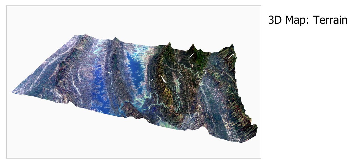
انشاء خرائط ثلاثية الأبعاد في برنامج #QGIS

A tutorial about how to create 3D Maps using QGIS?
Tutorial Link: youtu.be/ExHoKO8Ec8E?si=5UtW…
For more information about the registration link: studyhacksgeospatial.com/goo…
#QGIS #GeoAI #3DMap #Geospatial #terrain #map #Mapping #Geoscience #DEM #googleearthengine #GIS #remotesensing
19
Fadi chaaban retweeted

Jan 16
New in #ArcGISPro 3.6! Utilize Gaussian splats to provide highly realistic visualizations of complex geometry that can’t be achieved with traditional photogrammetric approaches. Watch how in this #ArcGISProShorts video: ow.ly/TXRt50XY8Kf
Learn more: ow.ly/MwUN50XY8KB
36
215
10,934
Fadi chaaban retweeted
🚨 عااااااااااجل :
اطلقت جوجل دورات مجانية في الذكاء الاصطناعي
لا توجد رسوم تسجيل أو مهارات مسبقة مطلوبة.
اليكم عشر دورات لا ينبغي تفويتها :
1. مقدمة في الذكاء الاصطناعي التوليدي
تعرّف على الذكاء الاصطناعي التوليدي في دورة بسيطة وقصيرة.
اكتشف كيفية بناء تطبيقات الذكاء الاصطناعي الخاصة بك باستخدام أدوات جوجل.
أكمل هذه الدورة التدريبية القصيرة التي تستغرق 45 دقيقة لتبدأ رحلتك في عالم الذكاء الاصطناعي
ـ skills.google/course_templat…
2. مقدمة الى نماذج اللغة الكبيرة
انضم إلى هذه الدورة القصيرة لفهم نماذج اللغة الكبيرة (LLMs).
تعرف على المجالات التي تكون فيها برامج الماجستير في القانون مفيدة وكيفية تحسينها.
اكمل هذه الدورة التدريبية التي تستغرق 45 دقيقة لبناء تطبيقات الذكاء الاصطناعي الخاصة بك
ـ skills.google/course_templat…
3. مقدمة في الذكاء الاصطناعي المسؤول
تعرّف على كيفية قيام جوجل ببناء ذكاء اصطناعي عادل ومفيد.
فهم المبادئ السبعة التي توجه تطوير الذكاء الاصطناعي الأخلاقي.
مثالي لأي شخص مهتم بأخلاقيات الذكاء الاصطناعي.
ـ skills.google/course_templat…
4. تصميم سريع في Vertex AI
اتقن فن التحدث الى الذكاء الاصطناعي لتحصل على ما تريد بالضبط.
تعلم كيفية إنشاء الصور والنصوص باتباع تعليمات بسيطة.
جرب تمارين عملية باستخدام احدث أدوات الذكاء الاصطناعي من جوجل.
ـ skills.google/.../course.../…
5. مقدمة في توليد الصور
شاهد كيف يمكن لأجهزة الكمبيوتر إنشاء صور واقعية من الصفر.
تعرف على الذكاء الاصطناعي المستوحى من الفيزياء والذي يدعم إنشاء الصور.
ـ skills.google/course_templat…
6. بنية المشفر-المفكك
اكتشف كيف تقوم الآلات بترجمة اللغات وتلخيص النصوص.
تعلم أساسيات معالجة اللغات الحديثة.
قم ببناء مولد النصوص الخاص بك باستخدام امثلة برمجية بسيطة.
ـ skills.google/course_templat…
7. الية الاهتمام
شاهد كيف يتعلم الذكاء الاصطناعي التركيز على ما يهم في النص والصور.
فهم السحر وراء نماذج اللغة الحديثة.
مقدمة سريعة لمدة 45 دقيقة لمفهوم الذكاء الاصطناعي الأساسي.
ـ skills.google/course_templat…
8. نماذج المحولات ونموذج BERT
تعرّف على التكنولوجيا التي أحدثت ثورة في مجال الذكاء الاصطناعي اللغوي.
انظر كيف يفهم BERT السياق في الجمل.
احصل على شارة رقمية مميزة عند الانتهاء
ـ skills.google/course_templat…
9. إنشاء نماذج لوصف الصور
قم ببناء ذكاء اصطناعي قادر على وصف ما يراه في الصور.
تعلم كيفية تدريب النماذج التي تربط بين الصور واللغة.
ـ skills.google/course_templat…
10. مقدمة الى برنامج Generative AI Studio
جرب أداة جوجل سهلة الاستخدام لبناء تطبيقات الذكاء الاصطناعي.
شاهد عروضًا توضيحية لكيفية تحويل الأفكار الى مشاريع ذكاء اصطناعي عملية.
ـ skills.google/course_templat…
للمزيد عن عالم الذكاء الاصطناعي، تابعنا في تيليجرام : t.me/Ai_Arabic1

11
240
850
77,432
Fadi chaaban retweeted
13 Oct 2025
🚀 Visualize Geospatial Data Instantly from the Command Line!
You can now interactively explore raster and vector datasets without opening a desktop GIS or Jupyter Notebook.
Simply run:
pip install "leafmap[viewer]"
Then visualize your data with one line:
view-raster /path/to/raster.tif
view-vector /path/to/vector.geojson
Customize your visualization easily:
view-raster /path/to/raster.tif --band 1 --colormap coolwarm
view-vector /path/to/vector.geojson --style liberty
These CLI tools are powered by Leafmap, MapLibre, and LocalTileserver, supporting all geospatial formats compatible with rasterio and geopandas.
👉 Check it out: github.com/opengeos/leafmap
#geospatial #datascience #mapping #python
6
38
248
13,454
12 Oct 2025
Digital Elevation Models: Terminology and Definitions mdpi.com/1263464 #mdpiremotesensing via @RemoteSens_MDPI
11
Fadi chaaban retweeted

10 Oct 2025
We’re opening up the waitlist today 👇
10 Oct 2025

𝗪𝗔𝗜𝗧𝗟𝗜𝗦𝗧 𝗜𝗦 𝗢𝗣𝗘𝗡 🚀
Meet Navi — your AI copilot for spatial apps
For too long, building spatial apps has meant wrestling with data formats, coordinate systems, and complex development frameworks. Simple ideas buried under technical complexity.
Navi bridges that gap — making spatial app development accessible to operations teams, analysts, and builders who understand their business challenges.
Waitlist: navi.atlas.co
3
3
282
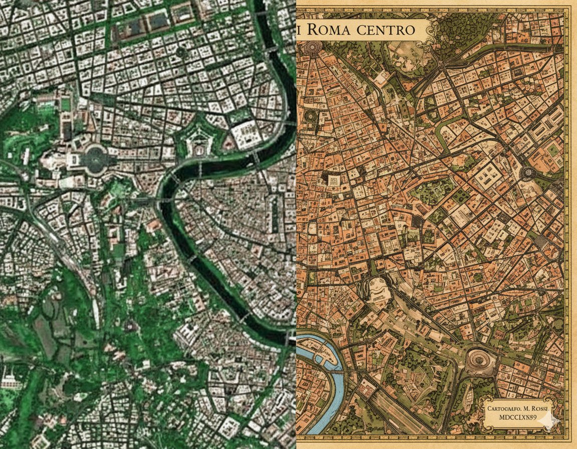
7 Oct 2025
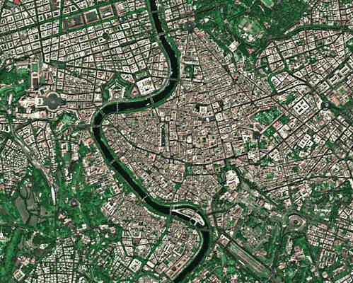
A satellite image of #Rome was fed into #Google #Gemini’s #NanoBanana 🍌🛰️. It redrew the city using classic Italian #cartography rules—turning raw data into handcrafted beauty.
Modern vs. historical perspectives. Which #map speaks to you more?
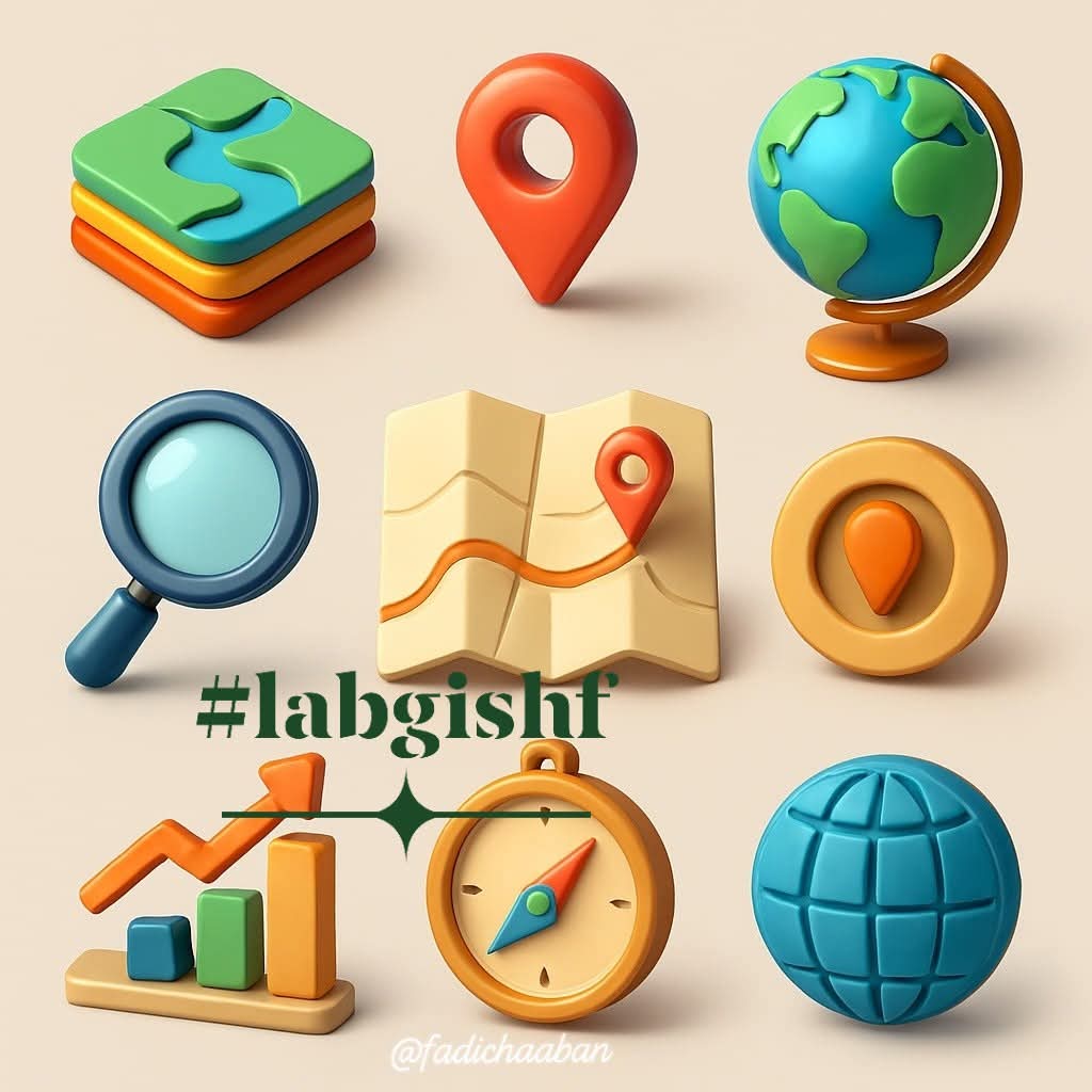
#fadichaaban #labgishf

96
Fadi chaaban retweeted
6 Oct 2025
Need satellite training data fast? 🛰️ In this step-by-step tutorial, learn how to prepare geospatial training data for deep learning in seconds using the free open-source GeoAI Python package. Whether you’re working with raster or vector data, this tool automates image tiling, annotation overlays, and deep learning prep in just one line of code!
✅ Exporting image chips from Single Image Single Vector
✅ Exporting image chips Multiple Images Single Vector
✅ Exporting image chips Multiple Images Matching Multiple Vectors
Video available on YouTube: youtube.com/@giswqs/videos
#DeepLearning #GeoAI #Python #ComputerVision #MachineLearning #AItools

2
35
236
7,238
1 Oct 2025
🚀 تحديث مهم لحزمة GeoAI في بايثون! أصبحت تدعم الآن إنشاء خرائط تفاعلية تستجيب للاستفسارات بلغة طبيعية—من الطيران إلى أي مدينة، إلى عرض المباني ثلاثية الأبعاد، وكل ذلك بدون كتابة كود. مثالية للباحثين والمطورين ومحبي GIS & AI .
#GeoAI #الخرائط #Python #AI #الذكاء_الاصطناعي #GIS
1 Oct 2025
🚀 Exciting news! The GeoAI Python package just got a major upgrade. It now supports interactive geospatial data visualization powered by AI Agents. 🌍✨
GitHub: github.com/opengeos/geoai
Full tutorial: youtube.com/@giswqs/videos
🌍 In this tutorial, you’ll learn how to build interactive maps powered by AI agents that respond to natural language queries. Watch how you can fly to any city, add raster or vector layers, visualize 3D buildings, and explore geospatial data—all without writing code. Perfect for developers, researchers, and anyone curious about AI, GIS, and interactive mapping.
#geospatial #mapping #python #GeoAI #AI
296
30 Sep 2025
يسرّنا مشاركتكم رابط تحميل (متاح 50 يوم فقط) مقالنا العلمي بعنوان:
"Spatio-temporal monitoring of sea surface temperature in the Syrian territorial waters (Eastern Mediterranean) using Landsat time series and Google Earth Engine platform"
1
37
30 Sep 2025
في هذا البحث، قمنا بتحليل التغيرات الزمانية والمكانية في درجة حرارة سطح البحر ضمن المياه الإقليمية السورية باستخدام بيانات Landsat ومنصة Google Earth Engine، مما يساهم في فهم ديناميكيات البيئة البحرية في شرق المتوسط.
1
26
30 Sep 2025
المقال متاح الآن على موقع ScienceDirect، ويمكنكم الوصول إليه مجاناً لمدة 50 يوماً عبر الرابط التالي:
🔗
kwnsfk27.r.eu-west-1.awstrac…
(صالح حتى 19 /11/ 2025)
#RemoteSensing #GoogleEarthEngine #Landsat #SST #EasternMediterranean #SyrianWaters #EnvironmentalMonitoring #GIS
26