
মহাকাশ প্রযুক্তি কীভাবে কৃষিক্ষেত্রে নতুন সম্ভাবনার দ্বার খুলে দিচ্ছে?
সম্পূর্ণ পর্বটি দেখুন - youtu.be/WJzZ0ryuS5k
#BigyanPrasange #SpaceTechnology #AgricultureTechnology #SpaceInAgriculture #ModernFarming #SatelliteTechnology #AgriInnovation #ScienceForFarmers #SmartAgriculture #KrishiOBigyan #AgriculturalDevelopment #ISRO #RemoteSensing #PrecisionFarming #ScienceCommunication #BengaliProgramme #DDBangla #ScienceAndTechnology #FutureOfFarming #DigitalAgriculture
11
বিগত কয়েক বছরে সরকারি এবং বেসরকারি উদ্যোগের যৌথ সমন্বয়ে ভারতের মহাকাশ গবেষণা এক অন্য মাত্রায় পৌঁছেছে। NISAR এবং মিশন দৃষ্টি এই দুই মিশনের সম্পর্কে বিস্তারিত জেনে নিন নিচের ভিডিওটিতে।
বিজ্ঞানের এরকম আরো বিষয় সম্পর্কে জানতে নিয়মিত দেখুন বিজ্ঞান প্রসঙ্গে প্রতি শনিবার বিকাল ৫:৩০ মিনিটে এবং রবিবার সকাল ১০:০০ টায়, ডিডি বাংলায়
সম্পূর্ণ অনুষ্ঠানটি দেখুন - youtu.be/WJzZ0ryuS5k
#NISAR #NASAISRO #SpaceResearch #EarthObservation #ISRO #NASA #SatelliteMission #ScienceAndTechnology #SpaceTechnology #Innovation #ClimateMonitoring #RemoteSensing #FutureOfScience #BharatInSpace #DDBangla #বিজ্ঞানপ্রসঙ্গে #মহাকাশগবেষণা #উপগ্রহপ্রযুক্তি #বিজ্ঞানওপ্রযুক্তি #ভারতেরগর্ব
7

Earth Index just opened to the public — a foundation model that lets you search the entire planet by visual similarity in satellite imagery. 🌍🔍
Read more: news.mongabay.com/short-arti…
#Geoawesome #GeoAI #EarthObservation #RemoteSensing
2
8
38
1,703

🌍 Behind the Journal – Meet the Experts!
We’re thrilled to introduce Karthikeyan Lanka, Associate Editor of IEEE Journal of Selected Topics in Applied Earth Observations and Remote Sensing (JSTARS), from IIT Bombay, Mumbai, India.
📌 Expertise: Microwave Radiometry, Data Assimilation.
How do you think data assimilation techniques can improve the accuracy of Earth observation and climate monitoring systems? Let us know in the comments, and explore more about the journal here: bit.ly/4tJEaT3
#IEEEGRSS #Research #remotesensing #IEEEXplore #JSTARS

2
4
242
🌃 Science by day, the Potomac by night — the IGARSS 2026 Banquet sets sail.
This year's banquet trades formal programming for connection, taking attendees aboard a scenic Potomac River cruise with Washington, D.C.'s skyline glowing in the background.
It's the evening to step away from the sessions, unwind, and build the relationships that make IGARSS more than just a conference.
Because some of the best collaborations start over dinner, not slides.
Aboard the cruise, you'll enjoy:
💠A curated dinner service with sweeping views of the Washington Monument and Lincoln Memorial from the water
💠Indoor comfort and open-air decks to take in the D.C. skyline by night
💠Onboard DJs spinning popular favorites all evening
💠Bonus: time to relax and network with colleagues and friends from around the world
🗓 Wednesday, 12 August 2026
🕖 7:30 PM – 10:00 PM (Transport pick-up 6:30 PM | Dock loading 7:00 PM)
📍 City Cruises, 580 Water St SW, Washington, DC 20024
🚌 All pick-ups & drop-offs at the Washington Hilton's T Street entrance
Who are you most looking forward to catching up with on the water?
👉 Save this post and don't miss one of the highlights of IGARSS 2026.
🎟 TICKETS HERE: 2026.ieeeigarss.org/registra…
#IEEEGRSS #IGARSS2026 #ConferenceBanquet #RemoteSensing #Geoscience #EarthObservation #WashingtonDC

2
1
405

A GeoAI model does not fail only when the code breaks.
It can fail when the world changes.
New buildings.
Different crop cycles.
New sensors.
Extreme weather.
Seasonal shifts.
Urban expansion.
In geospatial AI, model monitoring is not optional.
The landscape keeps moving.
#GeoAI #MLOps #RemoteSensing #Geospatial
8
Modern photogrammetric workflows demand both speed and precision. With the right tools, it is possible to streamline complex tasks and handle large datasets efficiently➡️ hubs.ly/Q04knc0L0
#AerialSurvey #Photogrammetry #RemoteSensing #Mapping #Drones
18

#Tripura | In a remarkable achievement for Tripura, Dr. Sourabh Paul, a native of Belonia in South Tripura district, has secured a prestigious research project funded by the Indian Space Research Organisation (ISRO), marking a significant milestone in his academic and scientific career.
Born and raised in Belonia, Dr. Paul completed his schooling in the town before pursuing higher education in engineering and research. He earned his Bachelor of Engineering degree from Tripura Institute of Technology (TIT), followed by a Master of Technology from National Institute of Technology (NIT), Agartala. He later obtained his Ph.D. from NIT Rourkela, specializing in signal and image processing.
Currently associated with the Vellore Institute of Technology (VIT), Chennai, Dr. Paul is actively engaged in advanced research in image processing, remote sensing and deep learning. Recently, ISRO sanctioned his research project titled “Design and Development of Algorithm for Illumination, Scale, Translation and Rotation Invariant Image Matching” with funding support of ₹29.93 lakh.
The project aims to develop advanced image-matching algorithms capable of accurately analyzing satellite images despite variations in illumination, scale, translation and rotation. Such technologies are crucial for remote sensing, environmental monitoring, disaster management and space-based observation systems.
Expressing gratitude to his teachers, mentors, colleagues and family members, Dr. Paul said that his journey from a small town like Belonia to receiving an ISRO-funded project demonstrates how determination and quality education can help achieve excellence. He expressed hope that his achievement would inspire students from Tripura and other small towns to pursue higher education, research and innovation.
The achievement has brought pride to Belonia, Tripura and the scientific community of the Northeast, highlighting the growing contribution of the region’s researchers to India’s space and technology sectors.
#DrSourabhPaul #BeloniaToISRO #ISROResearch #SpaceTechnology #ImageProcessing #RemoteSensing #ScientificAchievement #NortheastToday

36

Jun 13
PierSight has begun trials of a SAR system designed to image terrain beneath dense forest cover.
Source – analyticsindiamag.com/ai-new…
#DroneHelpline #Dronenewsdaily #SpaceTech #EarthObservation #SAR #RemoteSensing #PierSight

16

Every day, Earth observation satellites capture millions of square kilometers of our planet, transforming vast amounts of imagery into actionable intelligence.
From maritime monitoring and infrastructure planning to environmental analysis and security operations, satellite data helps organizations see beyond boundaries and make smarter decisions with confidence.
zamzamsatellite.com/
#EarthObservation #SatelliteImagery #RemoteSensing #GIS #SpaceTech #GeoAI #AI #ZamZamSatellite

1
11

Jun 13
🎓 PhD Studentship in Forest Structural Assessment 🇮🇪 | University College Cork
📌 Position: PhD in Forest Structural Assessment
🏫 University: University College Cork (UCC)
📍 Location: Cork, Ireland 🇮🇪
🏢 Department: Biological, Earth & Environmental Sciences
👨🏫 Supervisors: Dr. Markus Eichhorn & Dr. Ramiro Crego
📅 Deadline: July 5, 2026
⏳ Start Date: October 1, 2026
💰 Funding: €25,000/year fees research costs
🔬 About the Project
This fully funded PhD is part of the C-BioStock project, focusing on understanding forest structure, biodiversity, and carbon dynamics across forest harvesting cycles in Ireland.
Key research components include:
• Mobile terrestrial LiDAR scanning for 3D forest structure analysis
• Processing and visualization of LiDAR point cloud data
• Linking structural metrics to biodiversity (vegetation, birds, soil)
• Integration with airborne LiDAR and Earth Observation data
• Developing scalable indicators for carbon and biodiversity assessment
The project involves collaboration with national partners and includes opportunities for international research secondments.
👤 Ideal Candidate
• MSc in ecology, forestry, remote sensing, or related field
• Strong quantitative and programming skills (R, Python, MATLAB, etc.)
• Experience in research design and scientific writing
• Interest in LiDAR, GIS, or Earth Observation data (desirable)
• Ability to work collaboratively in interdisciplinary teams
🌟 Why Apply?
• Work on climate, biodiversity, and sustainable forestry challenges
• Gain hands-on experience with cutting-edge remote sensing technologies
• Collaborate with leading research groups across Ireland
• Opportunity for international research experience
• Fully funded position with strong academic support
🌍 Location Highlight – Cork
Cork is a vibrant and welcoming city known for its rich culture, coastal landscapes, and strong academic community, offering an excellent quality of life for researchers.
🔗 More Info:
phdscanner.com/opportunities…
#PhD #Forestry #RemoteSensing #LiDAR #ClimateChange #Biodiversity #Ireland #ResearchOpportunity #EnvironmentalScience #PhDPositions
2
195

Jun 13
🌍 Traditional GIS analysis has limits. AI doesn't.
🎓 AI & GIS: from classical ML to advanced AI methods for geospatial data
👇 udemy.com/course/ai-for-geos…
#GeospatialAI #MachineLearning #RemoteSensing
7

Jun 13
Great experience at the Japan Organization for Metals and Energy Security (JOGMEC), exploring the application of remote sensing and GIS in artisanal and small-scale mining.
#RemoteSensing #GIS #Mining #ASGM
22

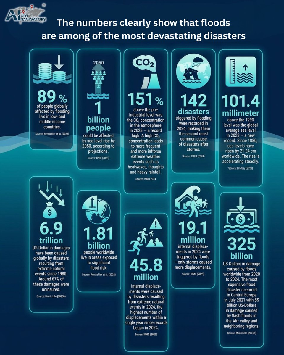
Floods are becoming one of the biggest risks facing communities, cities, and infrastructure.
The numbers are hard to ignore.
In 2024, floods triggered 142 disasters worldwide, making them the second-most common disaster after storms.
Between 2020 and 2024, flood-related damage reached more than US$325 billion.
And by 2050, up to 1 billion people could be affected by sea level rise.
These are not just environmental numbers. They are human, economic, and planning challenges.
Reducing flood risk means acting earlier, planning smarter, and using better data to understand where people, assets, and infrastructure are most exposed.
AI, geospatial intelligence, early warning systems, local knowledge, and nature-based solutions all have a role to play.
Floods cannot always be prevented, but their impact can be reduced.
Now is the time to turn risk data into real action.
What steps is your city, organization, or community taking to prepare for future flood risk?
@UNDRR
@WMO
@NASAEarth
@UNFCCC
@AiGeoNavigators
#FloodRisk #ClimateResilience #DisasterRiskReduction #GeospatialIntelligence #EarlyWarningSystems #ClimateAdaptation #UrbanResilience #NatureBasedSolutions #RiskManagement #SustainableCities #ClimateAction #GIS #RemoteSensing #DataForGood #ResilientInfrastructure
10

Happy Weekend from Panafrica Geoinformation Services! 🌍✨
Celebrating our geospatial community driving innovation across Ethiopia & Africa.
Wishing you a refreshing weekend!
#PanafricaGIS #GIS #Geospatial #RemoteSensing #Ethiopia

4

Jun 13
Coarse-to-Fine Multi-Platform Point Cloud Fusion 🚀
Different platforms (airborne, vehicle, handheld) produce point clouds with huge variations in viewpoint and features. Traditional loosely-coupled optimization often underutilizes matching info—global adjustments only reach suboptimal results, and overall alignment remains off. 🙅♂️
Our latest study in The Photogrammetric Record presents “Coarse-to-Fine Multi-Platform Point Cloud Fusion”, tackling multi-source registration challenges and poor global optimization performance! 😎
🛠 Our approach: Coarse-to-Fine
We propose a cross-platform point cloud fusion framework based on multi-feature global optimization:
1️⃣ Coarse step | Pose graph preconstruction 🗺️
Split mobile platform point clouds into blocks
Use bounding boxes flightline info for fast pose graph preconstruction
2️⃣ Fine registration | Local pairwise optimization 🔍
Extract multiple types of feature points
Select high-quality points using matrix info
Construct error equations with different distance metrics to solve relative poses
Remove mismatches via Frobenius norm 🧹
3️⃣ Tight coupling | Global optimization 🌐
Design residuals with zero-expected errors for smooth constraints
Solve all error equations iteratively in a tightly-coupled manner, improving overall point cloud consistency 📈
📊 Experiments
Tested on two real sites (Chengdu highway 🛣️ & Shenyang urban 🏙️), RMSE results:
🏆 Site 1: Accuracy 50.6%!
🏆 Site 2: Accuracy 44.7%!
From heavily vegetated highways to dense urban areas, the fusion results are visibly smooth.
📝 Paper Info
🔗 DOI: onlinelibrary.wiley.com/doi/… #PointCloudFusion #3DReconstruction #LiDAR #Surveying #RemoteSensing #Research #AlgorithmOptimization #MultiSourceData


2
11
Jun 13
City-Scale LiDAR Semantic & Instance Segmentation Dataset 🏙️
3D point cloud segmentation friends, tired of small or messy outdoor datasets that wreck model generalization? Say hello to WHU-Urban3D—6️⃣B annotated points, just published in ISPRS Journal! 🏆
Why we need it:
Previous datasets were either indoor, small, or poorly labeled. WHU-Urban3D fills the gap for real, complex urban scenes. 💪
🌟 WHU-Urban3D Highlights
1️⃣ Massive scale & full coverage 🏙️ Shanghai & Wuhan, airborne ALS (>3.2M m²) mobile MLS (>6.5 km), full urban 3D scene coverage
2️⃣ 6 billion precise labels 🏷️ 30 classes: buildings, vehicles, pedestrians… perfect to feed deep learning models
3️⃣ Rich attributes 🛠️ XYZ intensity, echo counts… multi-dimensional features boost model generalization 📈
4️⃣ Multi-modal fusion 📷 MLS panoramic images included for cross-data learning
💡 Applications: Intelligent transport, urban planning, AR/VR… unleash your models! 🔥
🔗 Open access
Dataset: whu3d.com/
Paper: sciencedirect.com/science/ar…
#PointCloud #DeepLearning #WHU #OpenDataset #RemoteSensing #ComputerVision #3DSegmentation #Research #AI

23

Remote sensing is now accessible to everyone, thanks to AI lowering the learning curve. Free satellite data and effective AI prompts can outperform expensive #RemoteSensing #AI #DataScience
7
🌟 Article of the Week 🌟
This week’s featured article from IEEE Journal of Selected Topics in Applied Earth Observations and Remote Sensing (J-STARS) highlights advances in deep learning for multitemporal remote sensing image change detection.
🔍 This Week’s Highlight
Title: B2CNet: A Progressive Change Boundary-to-Center Refinement Network for Multitemporal Remote Sensing Images Change Detection
Authors: Zhiqi Zhang, Liyang Bao, Shao Xiang, Guangqi Xie, Rong Gao
📖 🛰️ In this article, the authors propose B2CNet, a progressive change detection network guided by change boundary awareness and a boundary-to-center refinement strategy. The network enhances fine-grained boundary detection and improves internal region consistency by integrating boundary-aware modules and bitemporal feature aggregation, leading to more accurate change detection in multitemporal remote sensing images.
🔗 Read the full paper here: doi.org/10.1109/JSTARS.2024.…
Stay tuned for more groundbreaking research every week as we celebrate excellence in geoscience and remote sensing! 🌍📡
#IEEEGRSS #RemoteSensing #Geoscience #ChangeDetection #DeepLearning #JSTARS #ieeexplore #AOTW

4
14
617

Jun 12
MundoGEO Connect is just around the corner! If you'll be in São Paulo next week, schedule an appointment with our team to learn how Correlator3D can enhance your geospatial data production ➡️ hubs.ly/Q04lbRrd0
#AerialSurvey #Photogrammetry #RemoteSensing #Mapping #Drones
14