
Film buff, esp of #GeorgiaFilm. Location scout-ish. Entrepreneur. Beach bum. Scuba diver. Formerly #ATLMovieTours, now Dir of Marketing for Arival.Travel 🌴
Joined March 2009
- Tweets 25,844
- Following 2,596
- Followers 2,226
- Likes 15,388
1,325 Photos and videos


Carrie Sagel Burns retweeted

13 Oct 2025
What happens when they honk
41
826
14,704
685,788

7 Jul 2025
Thank you to @MerriamWebster for the lesson and now we can all just stop with calling that a “micro-retirement” k @FastCompany?
7 Jul 2025

'Vacations.'
The word is 'vacations.'
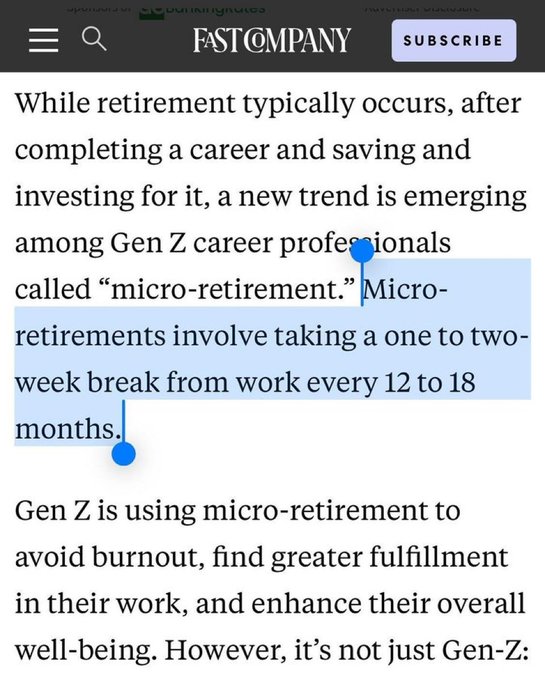
ALT FAST COMPANY Article: While retirement typically occurs, after completing a career and saving and investing for it, a new trend is emerging among Gen Z career professionals called "micro-retirement." Micro- retirements involve taking a one to two- week break from work every 12 to 18 months. Gen Z is using micro-retirement to avoid burnout, find greater fulfillment in their work, and enhance their overall well-being. However, it's not just Gen-Z:
123
Carrie Sagel Burns retweeted

10 May 2025
To some of you in Northern Georgia, yes, that was an earthquake you felt a little bit ago. Here is more from @USGS_Quakes:
earthquake.usgs.gov/earthqua…
131
281
844
160,793
5 May 2025
This should be illegal and it’s 100% how you control the media. Offering incentives on a country-wide basis is what’s needed, much like state incentives. Canada and the UK are doing it better.
4 May 2025

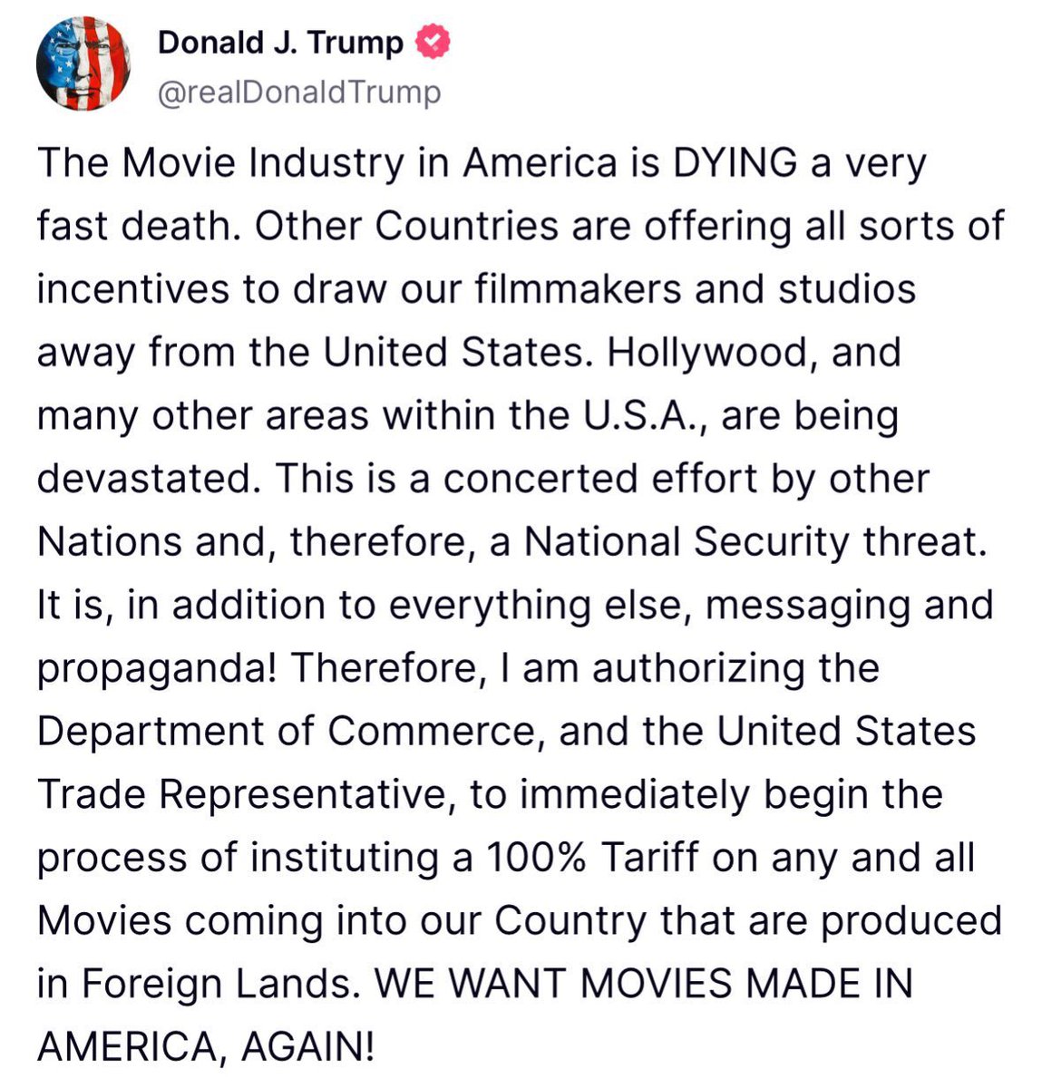
Donald Trump claims he is placing a 100% tariff on all films produced outside of America that are brought into the country.
“Any and all movies coming into our country that are produced in Foreign Lands. WE WANT MOVIES MADE IN AMERICA, AGAIN!”

92
30 Jan 2025
Passenger Jet and Helicopter Collide Near Reagan National Airport, Prompting Emergency Response haiku.ainewsbrew.com/article… #AINewsBrew #Haiku via @ainewsbrew
2
222
9 Jan 2025
Really?!? 🤪
Wordle 1,300 5/6
🟩🟩⬜⬜⬜
🟩🟩⬜🟩🟩
🟩🟩⬜🟩🟩
🟩🟩⬜🟩🟩
🟩🟩🟩🟩🟩
65
3 Jan 2025
As if you needed another sign to do #DryJanuary...US Surgeon General Issues Advisory Linking Alcohol to Increased Cancer Risk haiku.ainewsbrew.com/article… #AINewsBrew #Haiku via @ainewsbrew
1
117
3 Jan 2025
Since our tree replacement, this is the 2nd (at least) time we’ve had drivers pull up onto the sidewalk to park a delivery vehicle 🤷♀️🤦♀️ I mean, there are tree beds & a curb! @CintasCorp may want to advise driver 🤪
62

28 Dec 2024
🔥🔥🔥
28 Dec 2024
29
Carrie Sagel Burns retweeted

25 Dec 2024
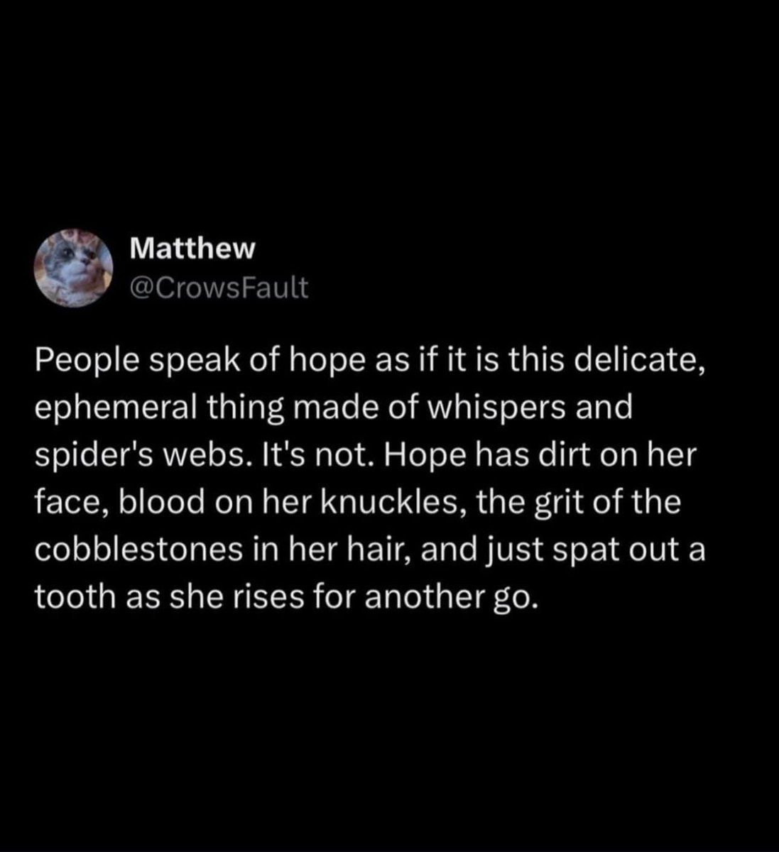
“You’ll be visited by three spirits.”
The three spirits:

38
959
10,182
485,718
21 Dec 2024
Why do I always think the fact that someone’s double-checking the receipt on the way out of @Costco means I don’t have to 🤦♀️ An hour round trip not counting in-store to find double charge on 1 pack of tissues and 19 items, not the 20 listed 😵💫
41
Carrie Sagel Burns retweeted

9 Nov 2024
I’m sorry I couldn’t properly lead to this beautiful tribute the @CollegeGameDay put together. Really wanted to thank all of you for the avalanche of love and support you’ve shown Ben. It gives me and my family such comfort knowing how he impacted so many peoples lives around the country. He was a beautiful and loving soul.
6,570
19,149
210,359
10,386,368
Carrie Sagel Burns retweeted

5 Oct 2024
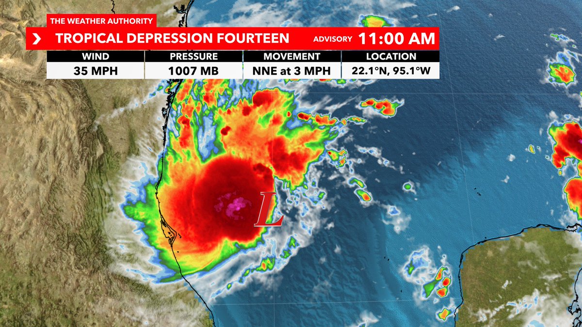
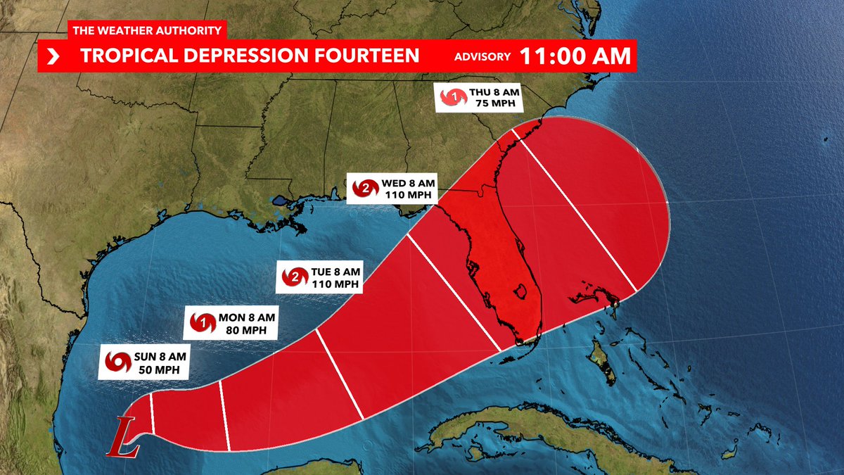
#BREAKING: First cone is out with a Florida hurricane expected Tuesday into Wednesday across the state. Initial landfall intensity from the NHC is upper Cat 2 and near Cat 3. Next name is #Milton. Here are my thoughts as of Saturday:
1. This system is unfortunately already organizing at a quick pace over warmer than average water temps in the Gulf Mexico for October.
2. For that reason, I do agree that this will intensify into a hurricane in the days ahead. Can't rule out a Major Hurricane at peak intensity *IF* favorable ingredients come together.
3. Current highest probability for landfall is between Hernando Beach to Everglades City, which includes potential tracks through Tampa Bay or Southwest Florida. Although model changes are always possible, they will start to tighten up with greater accuracy over the next day or two. When that gradually occurs soon, we will be able to give you more specifics on local surge, wind, etc. Reminder that every storm is different in the impacts they bring and those impacts will be felt outside of the cone too.
4. IMPORTANT: Surge will again be a problem for a portion of our western Florida coastline. This is a unique and rare angle of approach from the southwest. That means that if you're on the southern side of the storm you will be getting surge to a certain degree. *CLOSEST TO THE SOUTHERN HALF OF THE EYEWALL WILL GET THE HIGHEST SURGE.* That's why landfall location is important with this storm. Every mile makes a difference! If you're north of the center, your wind will be coming in from a different direction and from the land...more likely to suck the water out at landfall. Some surge is still possible north after the storm exists, but not to the level compared to those south of the center.
5. Remain calm. Now is the time this weekend to review your hurricane plan with your family or friends. Grab necessities, but don't overstock! Remember about our neighbors and others in the community. If you are told to evacuate, please do so!
You're in good hands here at WINK. I will guide you through the entire storm 24/7 from start to finish, without the hype and with information you need. Make sure to tune into WINK News for the latest all week.
286
1,804
6,043
1,416,810
Carrie Sagel Burns retweeted

23 Sep 2024
ICYMI:
23 Sep 2024

Sam Elliott's Cussing In Folksy Ad May Make You Giddyup To Vote For Harris huffpost.com/entry/sam-ellio…
160
1,727
7,362
753,215
21 Sep 2024
In 2017, I paid Cards Against Humanity to protect a pristine plot of border land from Trump’s racist wall. But then an even richer, more racist billionaire—Elon Musk—stole my land and dumped his shit all over it. @ElonMusk owes me $100. #ElonOwesMe100Bucks ElonOwesYou100Dollars.com
1
39
Carrie Sagel Burns retweeted

19 Aug 2024
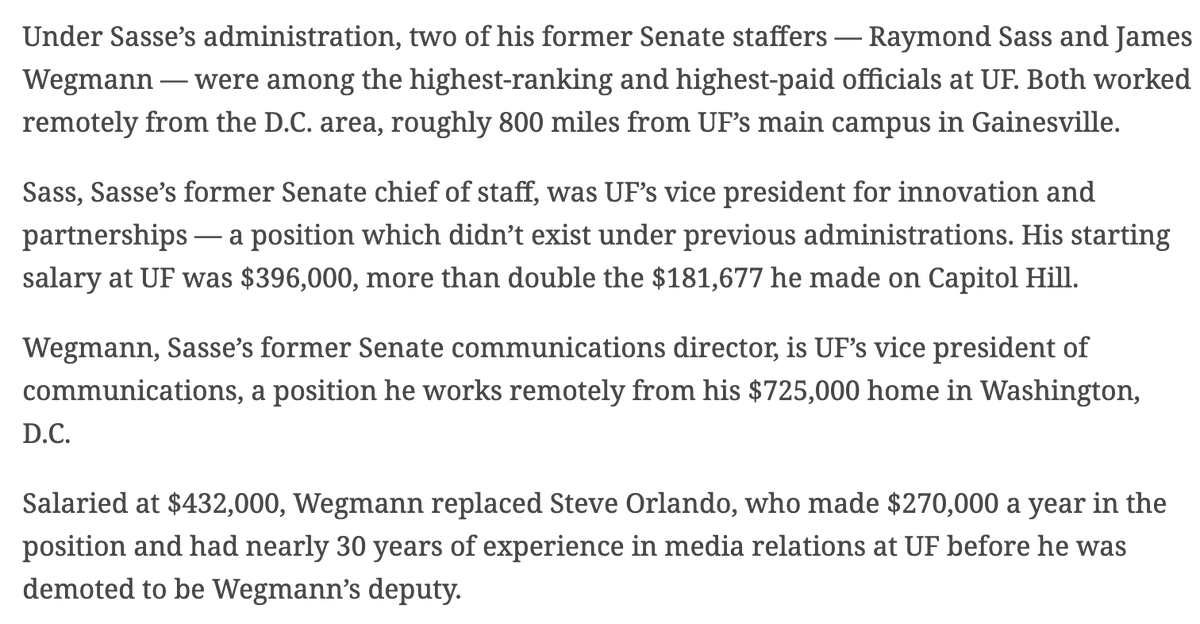
This is an absolutely bonkers story about how former Nebraska Sen. Ben Sasse has spent millions of dollars as U of Florida's new president hiring his former staffers for made-up, insanely high paid *remote* jobs at the university. alligator.org/article/2024/0…

208
2,502
8,040
778,244
Carrie Sagel Burns retweeted

31 Jul 2024
This former professor of political science gives two reasons why Kamala Harris is going to win. Pay close attention to the second reason because it's a biggie. As in 'game over' biggie. 😊
546
1,856
9,859
983,132
12 Jul 2024
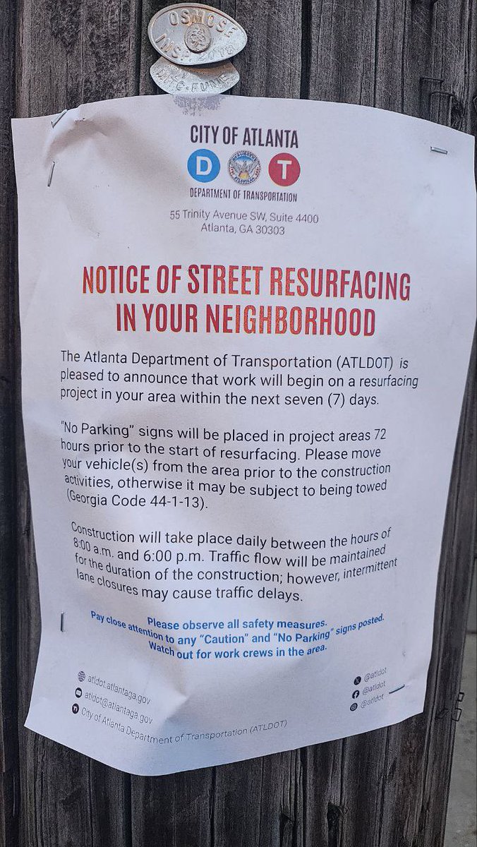
Interesting to see people in Houston talking about the ongoing need for tree trimming, now exacerbated by the flooding when it’s the same here in @CityofAtlanta & every @ATL311 ticket we open is closed w/o trimming. Love the canopy, but needs to be maintained 🙏🌳
1
144