
I’m an engineer. I believe all technology should be both ergonomic and intuitive. MEGASTRUCTURES! US must lead in AI. Moon → Mars → Ceres → Stars. 🇺🇸 🚀 🦾
Joined November 2022
- Tweets 1,008
- Following 318
- Followers 364
- Likes 402
228 Photos and videos


Pinned Tweet

18h
Recap:
Tugs will enable 50% more landed mass on the lunar surface compared to sending lunar landers directly on a Trans-Lunar Injection (TLI) trajectory. The general concept is straightforward: a tug and lunar lander are launched together as a stack into Low Earth Orbit (LEO). The current Falcon Heavy limit in partially expendable mode is 57 metric tons (MT), and landed lunar mass scales directly with LEO launch capacity.
Once in orbit, the tug performs TLI and Lunar Orbit Insertion (LOI). After separation, the lander remains in a circular Low Lunar Orbit (LLO) until it is commanded to descend, while the tug executes a Trans-Earth Injection (TEI) and uses aerobraking to reenter LEO.
I also have concepts for a reusable heat shield that would allow the same tug to make multiple round trips between LEO and LLO. This architecture would require on-orbit refueling with liquid hydrogen (LH₂) and a Nuclear Thermal Propulsion (NTP) engine on the tug. I assumed an Isp of 800 s for the tug and 350 s for the lander. All of the required technologies either already exist or are just over the horizon.
Overall, tugs would dramatically accelerate the buildout of lunar infrastructure compared to traditional approaches.
Background:
Before Nixon's OMB killed the program in January 1973, @NASA had a nuclear rocket engine research program at Plum Brook Station (PBS) in Sandusky, OH. Their hot-fire test facility was located at the Nuclear Rocket Development Station (NRDS) in Jackass Flats, NV. They learned a lot about nuclear rocket propulsion from 1961 to 1972. They had fires and explosions along the way but managed to build several different engines. These included the Kiwi, Phoebus, and NERVA variants. The best one they produced, IMO, was the NERVA XE. It had an Isp of 811 s, a maximum thrust of 75,000 lbf, and a best thrust-to-weight ratio (TWR) of about four. Project Timberwind / SNTP (Space Nuclear Thermal Propulsion) developed in late 80's and early 90's under the SDI promised a TWR of around thirty. The most recent design, by @DARPA program Demonstration Rocket for Agile Cislunar Operations (DRACO 2020-2025) was just recently cancelled. The TWR for DRACO was much lower than previous designs because they used a significantly lower enrichment of the U235. They improved the materials science but shot themselves in the foot by switching from HEU to LEU. The earlier programs had used HEU and were showing real progress over time.
We gave up too soon on NTP in favor of NEP. NEP just does not have the thrust we need for deep space exploration and colonization!
🇺🇸 🚀 🦾
@NASAAdmin
@CrainTim
@Jason_Lil_Kim
@astrobotic
@blueorigin
@SpaceX


2
93
Jun 3
Money is important!
Jun 2

A mathematics professor once discovered that the sink in his kitchen had broken. He called a plumber, who arrived the next day, tightened a few fittings, and quickly fixed the problem.
The professor was pleased—until he saw the bill.
“This is a third of my monthly salary!” he exclaimed.
Still, he paid it. As the plumber was leaving, he said, “I understand your situation. Why not join our company? You could earn much more than you do now. Just one thing—when you apply, say you only finished elementary school. They prefer that.”
The professor, intrigued, followed the advice. To his surprise, he was hired. The work was simple—occasional repairs, tightening pipes—and his income improved dramatically.
Some time later, the company introduced a new rule: all employees had to attend evening classes to complete basic schooling. The professor had no choice but to attend.
On the first day, the subject was mathematics. The instructor asked a student to write the formula for the area of a circle on the board. The professor was chosen.
He walked up confidently—but then hesitated. He couldn’t recall the formula.
Determined, he began deriving it from scratch. The board quickly filled with integrals, derivatives, and complex expressions. After several minutes of work, he arrived at a result:
−πr²
Unsatisfied with the negative sign, he tried again. And again. Each time, the same result appeared.
Frustrated, he turned to the class. Behind him, the other plumbers were whispering to one another:
“Switch the limits of the integral.”
1
233
FlyIt retweeted

NASA is aware of the anomaly that occurred tonight at Launch Complex 36 involving Blue Origin’s New Glenn rocket at Cape Canaveral Space Force Station.
Spaceflight is unforgiving, and developing new heavy-lift launch capability is extraordinarily difficult. We will work with our partners to support a thorough investigation of this anomaly, assess near-term mission impacts, and get back to launching rockets.
We will provide information on any impacts to the Artemis and Moon Base programs as it becomes available.
623
1,672
18,938
972,928
May 29
3
97
May 28
Each MoonFall hopper will have HD video and photography capability.
Each MoonFall hopper will have Ground Penetrating RADAR (GPR) and a Neutron Spectrometer.
Each MoonFall hopper will have a LASER Retroreflector Array.
Each MoonFall hopper will have a Radiation Spectrometer.
@FireflySpace and @NASA should get very valuable data. This will be a huge moment. @NASAAdmin 🇺🇸 🚀 ✝️ 🙏

Four JPL-built propulsive drones – known as MoonFall – will survey the lunar surface at potential @NASAArtemis landing sites in unprecedented detail. The mission is part of the initial phase of the @NASAMoonBase initiative.
Learn more: jpl.nasa.gov/missions/moonfa…
2
2
156
May 27
Hell yes! A real base on the Shackleton Connecting Ridge! It’s a brilliant start.
Because of the ridge's location, you have a direct line of sight with Earth whenever it rises above the lunar horizon, which lasts for about 13.5 days at a time. For the other 13.5 days of the month, the base will rely on the Khon-2 satellite for communications. Intuitive Machines (@Int_Machines) will drop Khon-2 into lunar orbit during their IM-3 mission before attempting their landing at Reiner Gamma.
But when Earth is visible? The view from the Shackleton Connecting Ridge will be spectacular. Because of the Moon’s libration, Earth will trace a slow, vertical figure-8 in the lunar sky over the course of a tropical month. It will spend roughly half the month in the top loop of the '8' and the other half in the bottom.
The link below allows you to view a very well made video and some infographics that will help you understand what the astronauts looking at Earth from our first moon base will see.
sky-lights.org/2021/11/22/ea…
@NASAAdmin @CrainTim
1
1
7
884
May 27
As viewed from the base, the angular size of this celestial '8' will stretch 15.8° from top to bottom and 13.4° from side to side, with the lunar horizon roughly bisecting the middle.
1
59
May 23
NASA’s Space Reactor-1 (SR-1) mission utilizes a closed Brayton-cycle fission reactor. The reactor will generate electricity to power a Nuclear Electric Propulsion (NEP) engine, commonly known as an ion engine. The mission is scheduled to launch during the next Earth-Mars transfer window in December 2028, with an estimated transit time of about one year to reach Mars.
SR-1 will carry three helicopters that will deploy from the descent platform while it is still airborne. This effort is known as the Skyfall Project. The helicopters are very similar to the Ingenuity helicopter, which successfully completed 72 flights on Mars before its mission ended.
Because SR-1 will use the Power and Propulsion Element (PPE) originally designed for the postponed Lunar Gateway, along with the proven technology demonstrated by Ingenuity, NASA was able to save enough development time to target the late-2028 Hohmann transfer window.
To the best of my knowledge, @NASA has not yet finalized the region of Mars that the Skyfall Project will explore and map.
Many people argue that the first human missions should target the large flat regions near the Martian equator. Arcadia Planitia is often cited as a leading candidate for the first Martian colony because of its relatively safe landing terrain and the presence of abundant subsurface water ice. Those are compelling advantages.
What is discussed less often is surface radiation exposure and meteorite impact frequency. Both are higher there than they need to be.
In my opinion, Hellas Planitia is the better long-term option. Its terrain is rougher than Arcadia Planitia, with hills and crevices separating flatter regions, but it also has major advantages.
Hellas Planitia sits approximately 7 km lower in elevation, meaning there is more atmosphere above it compared with Arcadia Planitia. That additional atmospheric shielding slows down and breaks apart many meteorites that would otherwise strike the surface intact.
The thicker atmosphere also reduces radiation exposure at the surface. Lower radiation levels would contribute to healthier colonies.
Finally, Hellas Planitia experiences persistent winds that would support wind-powered turbines. Unlike solar arrays, wind power would remain available during dust storms and throughout the long Martian night.
@NASAAdmin @NASAJPL @NASAMars @SpaceX
youtube.com/watch?v=TYasUWRk…
1
2
6
1,254
May 24
There are more advantages to locating the first human colonies on the Hellas Planitia.
Here’s one advantage that @elonmusk will appreciate. The Hellas Planitia is literally the best place on the entire planet to make CH4. The air is twice as dense there as it is on Arcadia Planitia. A Sabatier reactor requires 1 to 3 bar of internal pressure to work properly and it generates a lot of heat while it is working.
CO2(g) 4H2(g) 30 kJ/mol [Startup Heat] --(Ni(s) catalyst)--> CH4(g) 2H2O(g) 195 kJ/mol [Total Heat Evolved]
By locating CH4 production on the floor of Hellas Planitia, you basically cut in half the hardware mass required to feed the Sabatier reactor. You only need roughly half the volume of Martian atmosphere feeding the reactor on Hellas Planitia that you would need on Arcadia Planitia. Intake fans and piping mass is reduced dramatically.
The thicker air on Hellas Planitia will aid with convective cooling of the Sabatier reactor vessel if needed. The waste heat evolved during the reaction could also be used to heat the habitats/work areas in the colony.
There is a potential problem with using unfiltered Mars atmosphere to feed the reactor. There are small amounts of sulfates and perchlorates in the Martian air. Sulfur will poison the Ni catalyst and Cl will combine with H to form HCl. HCl will attack and pit the steel components of the reactor.
A 3-stage chemical guard should solve the problem. Use a vortex to spin out all but sub-micron size dust particles. Then use HEPA/ULPA filters to remove the rest of the dust. Finally, use a sorbent bed of activated carbon to remove the unwanted chemicals. A zinc oxide ‘polisher’ sorbent bed could be added to remove any sulfur remaining.
This is just another reason to build on Hellas Planitia!
@NASAAdmin @SpaceX
 
1
65
May 23
I am concerned about NASA’s current timeline for Artemis. I don’t see how @SpaceX can possibly be ready with the HLS spacecraft for orbital testing before the end of 2027.
At this point, @blueorigin is the only company that has a realistic chance of being ready by the current scheduled Artemis III launch date of late 2027.
One requirement that @NASA insists on–and rightfully so–is the ability for the HLS pilot to take manual control of the spacecraft if the software is guiding it towards an unsafe landing. This exact capability is what saved Apollo 11.
To the best of my knowledge, SpaceX has not planned to enable any type of manual control of HLS during the lunar landing phase.
An automated landing system has served SpaceX well on concrete pads and drone ships, here on Earth, but carries too many risks to ever be human-rated for making lunar landings, without a manual override system being available.
@NASAAdmin
2
102
May 10
Thoughts on Deep Space Travel
The road to Mars runs through the Moon.
We must master living and working in the lunar environment before we can hope to thrive on Mars. This isn’t just about proving hardware. It’s about proving the people.
Space is trying to kill you 24/7.
Vacuum. Radiation. Temperature extremes.
These are known engineering problems with decades of solutions already in hand. Iterative improvements continue.
What we haven’t solved is the human mind in deep space.
Low Earth Orbit (LEO) is not deep space. In LEO, you’re hours from rescue and still wrapped in Earth’s magnetosphere. In deep space, that safety blanket disappears. The psychological pressure is radically different—and largely untested.
The human mind craves safety. Under prolonged isolation, radiation exposure, and the knowledge that Earth is months away, some will adapt. Others will break. A few may self-destruct.
This is why the Moon comes first.
We already screen astronauts on Earth. We reject many. That’s not enough.
Candidates must prove themselves in cislunar space—far enough to feel the void, close enough to still have options. Only after living and operating beyond Earth’s magnetosphere can NASA, SpaceX, Blue Origin, or any partner certify them for true deep space.
The Gateway: An EML-2 Orbital Outpost
A space station/dry-dock at Earth-Moon L2 is the logical next step. Built and supplied by both Earth and lunar industry, it becomes humanity’s proving ground for Mars missions.
Astronauts will live, train, and be tested there—physically and psychologically. More will wash out. Some will quit.
Only the truly ready will proceed.
Looking Further: The Interstellar Step
Once Mars has a mature industrial base, we build the next major waypoint.
I favor Ceres.
Why Ceres?
• Abundant water ice
• Rich in Al, C, Fe, Si, Ti
• Far lower meteorite impact rate than the Moon or Mars
• Radiation environment nearly identical to the lunar surface
No need for deep underground habitats like on the Moon, but radiation shielding remains essential. Just as the EML-2 station draws from Earth Moon, the Ceres station will be supplied by Mars Ceres resources.
This is how we expand: step by step, testing both machines and people at each new distance.
The Moon isn’t a detour.
It’s the necessary filter.
@NASAAdmin @elonmusk @JeffBezos @SpaceX @BlueOrigin
1
2
126
May 10
Follow-Up Post: Lunar Gateway Isn’t Dead — It’s Ready for a Major Upgrade.
The road to Mars still runs through the Moon — and the Lunar Gateway is still part of that road.
NASA didn’t kill the Gateway.
On March 24, 2026, Administrator Jared Isaacman announced it was paused in its current form. The focus rightly shifted to building a sustained human presence on the lunar surface first. Boots on the ground. Infrastructure that lasts. That’s smart sequencing.
But let’s be clear: the Gateway is not cancelled.
Hardware is already built. International partners are committed. Valuable modules like HALO and the Power & Propulsion Element exist and can be repurposed. This is not a sunk cost — it’s a head start.
What we actually need is a far larger Lunar Gateway/Dry-Dock.
The original design was modest — a small waypoint in Near-Rectilinear Halo Orbit. Helpful, but too limited for what comes next.
We need to redesign and scale it up dramatically:
• Reuse every piece of existing hardware that still works.
• Add massive new modules for crew training, psychological testing, and long-duration deep-space simulation.
• Expand it into a true orbital dry-dock at EML-2 where we can assemble, test, and launch Mars-bound vehicles.
• Make it the proving ground where astronauts live for months in the exact radiation and isolation environment they’ll face en route to Mars.
This bigger Gateway becomes the filter we’ve been missing:
Screening on Earth isn’t enough.
Surface time on the Moon is essential — but cislunar deep-space time is non-negotiable.
Only after crews have lived, trained, and been tested far beyond Earth’s magnetosphere — with Earth still “close” enough for rescue — can we certify them for the six-to-nine-month voyage to Mars.
The Moon gives us the industrial base.
The enlarged Gateway gives us the deep-space test environment we need.
NASA’s pause was the right tactical move.
Now let’s turn it into the strategic masterstroke: repurpose what we have, think bigger, and build the Gateway/Dry-Dock humanity actually needs for the journey outward.
The original vision was too small.
The next version must be interstellar-ready.
Moon first.
Gateway upgraded.
Mars next.
Ceres after that.
By then, God willing, we will be ready to build a spacecraft for our first interstellar trip.
@NASAAdmin @elonmusk @JeffBezos @NASA @SpaceX @BlueOrigin @CrainTim @Int_Machines @Jason_Lil_Kim @FireflySpace
1
2
150
May 10
Complementary Heavy Lift: Let Blue Origin (or another American company) Build the Hydrolox Beast
Here’s how America dominates the next era:
While SpaceX perfects methane/LOX Starship for Earth-to-Moon-to-Mars cadence, Blue Origin — or another U.S. partner — should develop a large, hydrogen/LOX transport spacecraft in the same class.
• Hydrogen offers superior specific impulse for heavy cislunar and deep-space hauls.
• It pairs perfectly with lunar oxygen ISRU.
• A methalox Starship a hydrolox Blue Origin heavy hauler creates a complementary fleet: density and reusability where it counts, raw efficiency where it matters most.
This dual-track approach puts the United States in the strongest possible position as we expand outward. No single point of failure. Maximum innovation. American leadership across the entire architecture.
The Moon gives us the industrial base.
The enlarged Gateway proves our people.
A mixed-propellant fleet gives us unmatched logistics muscle.
Moon first.
Gateway upgraded.
Mars next.
Ceres as the interstellar shipyard.
This is how we move from explorers to a true multi-planet civilization — faster, safer, and entirely on American terms.
@NASAAdmin @elonmusk @JeffBezos @NASA @SpaceX @BlueOrigin @CrainTim @Int_Machines @Jason_Lil_Kim @FireflySpace
1
130
Apr 25
Meant to include you in this Casey. The 2nd image used one of your .kml files. I also want Bill to weigh in on the idea of locating first colonies based on a future road or rail line between PSRs. @CJHandmer @LunarCaveman
Apr 25

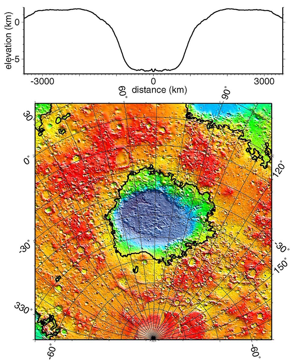
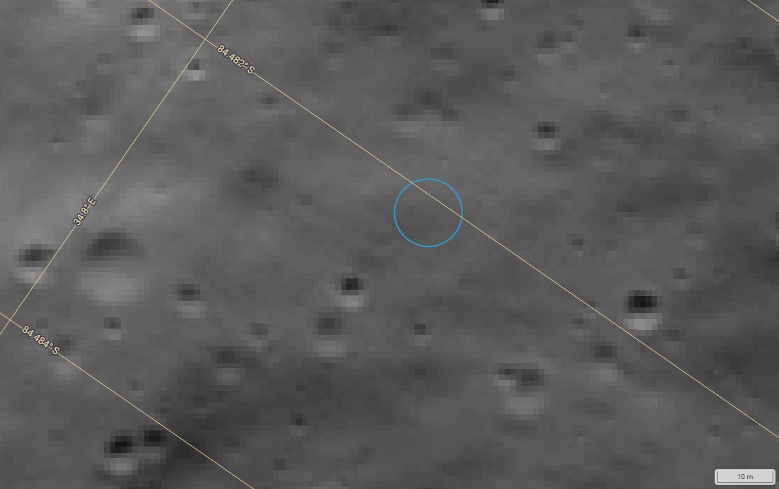
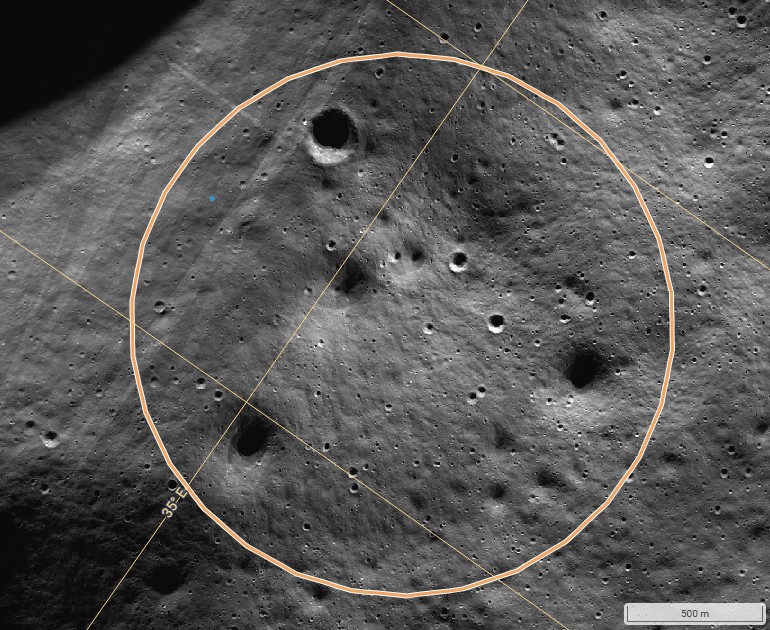
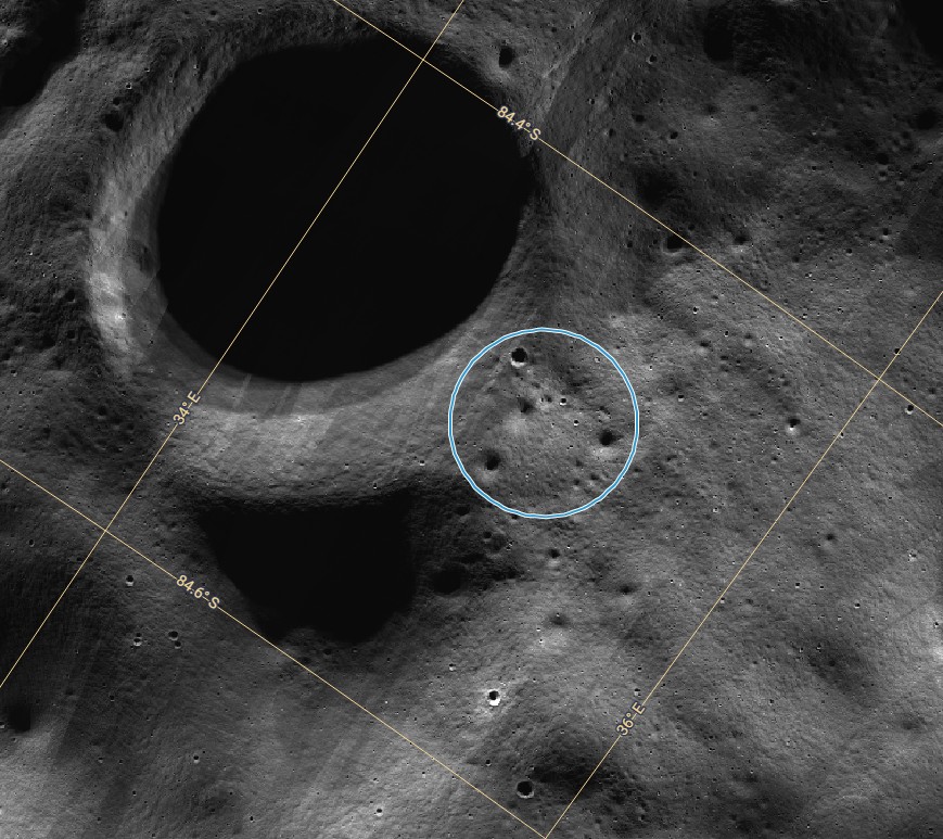
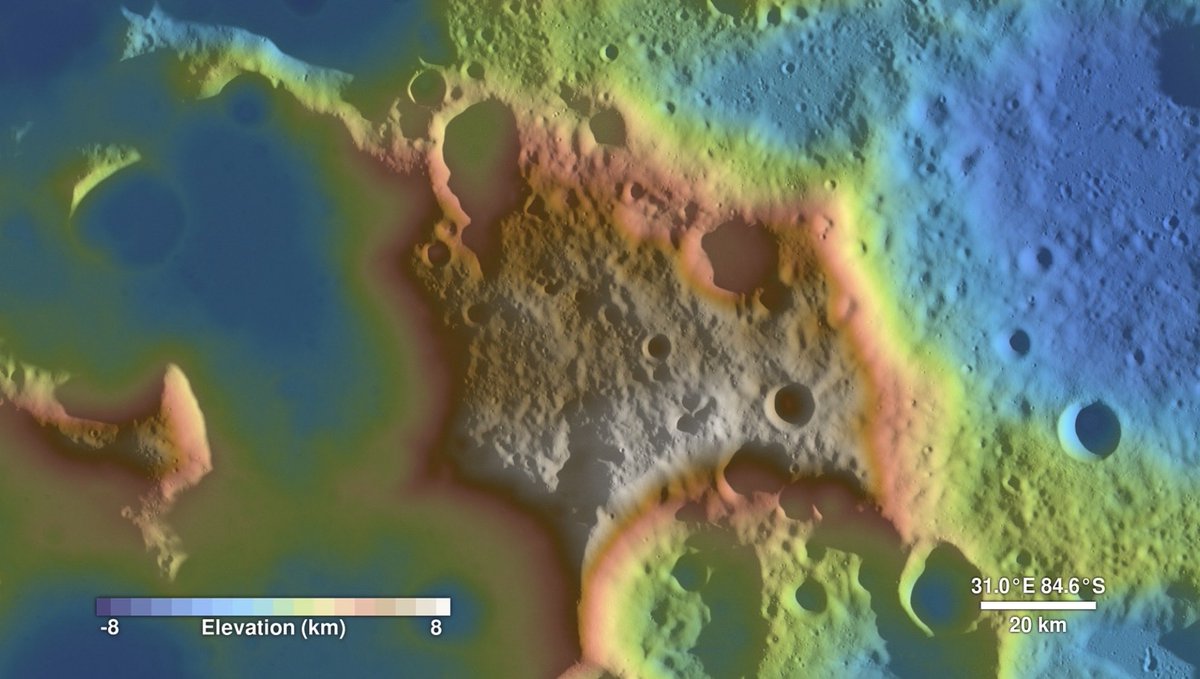
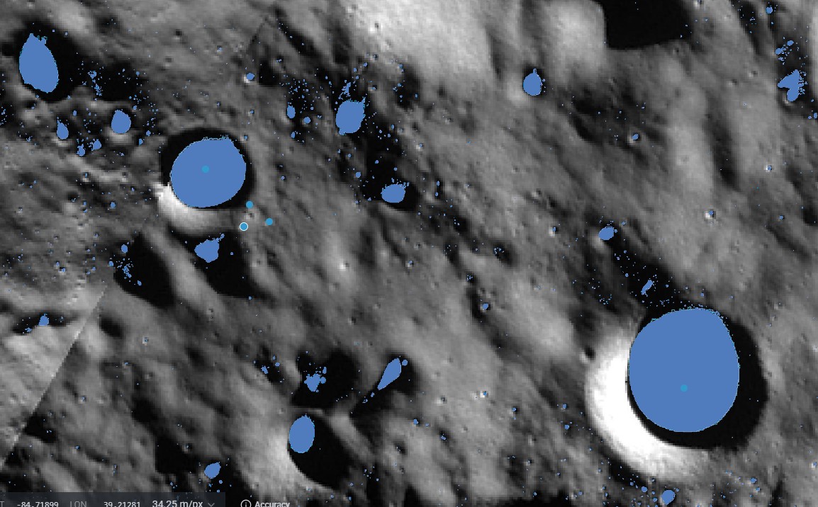
This is Mons Mouton. It lies between the Nobile and Malapert craters in the lunar South Pole region. In the first image, north is at the top. The elevation is color-coded from lowest to highest as follows: blue, green, yellow, red, brown, and white. The south and southeast portions of Mons Mouton are the highest parts of the feature. Near these high points, it has a clear line of sight to Earth and receives full sunlight for a large percentage of the year. It offers gentle 3°–5° sloped pathways around the steeper, intermittent hills that have 10°–15° slopes—ideal terrain for exploration by rover. There are thousands of unnamed craters on the plateau itself that contain small Permanently Shadowed Regions (PSRs) which could hold water ice. These small craters should be explored before venturing into the larger, more dangerous PSRs at the lower elevations below the plateau. When deciding where to build on the plateau, one location stands out. It would lie on a line between the two largest PSRs on Mons Mouton. In fact, this route would be an excellent location for the first lunar road, and possibly the first lunar railway. The distance between the two PSRs is approximately 26 km. The largest PSR is located at -82.26, 42.29, and the second largest is at -84.46, 33.99. The second largest PSR is the most interesting to me because it features a small triangular area on its eastern rim that appears to be an ideal landing site. I have identified a triangle with nearly equal sides (about 1.25 km each) with a small PSR at each vertex. American astronauts landing anywhere inside this triangle would have a PSR just a short rover ride away; in fact, they could easily walk to one from the landing site. If the first site turns out to be a "dry hole," there are two other small craters and one very large one in close proximity to the landing site with PSRs.
@CrainTim @Jason_Lil_Kim @elonmusk @JeffBezos @NASAAdmin

1
188
Apr 25
This is Mons Mouton. It lies between the Nobile and Malapert craters in the lunar South Pole region. In the first image, north is at the top. The elevation is color-coded from lowest to highest as follows: blue, green, yellow, red, brown, and white. The south and southeast portions of Mons Mouton are the highest parts of the feature. Near these high points, it has a clear line of sight to Earth and receives full sunlight for a large percentage of the year. It offers gentle 3°–5° sloped pathways around the steeper, intermittent hills that have 10°–15° slopes—ideal terrain for exploration by rover. There are thousands of unnamed craters on the plateau itself that contain small Permanently Shadowed Regions (PSRs) which could hold water ice. These small craters should be explored before venturing into the larger, more dangerous PSRs at the lower elevations below the plateau. When deciding where to build on the plateau, one location stands out. It would lie on a line between the two largest PSRs on Mons Mouton. In fact, this route would be an excellent location for the first lunar road, and possibly the first lunar railway. The distance between the two PSRs is approximately 26 km. The largest PSR is located at -82.26, 42.29, and the second largest is at -84.46, 33.99. The second largest PSR is the most interesting to me because it features a small triangular area on its eastern rim that appears to be an ideal landing site. I have identified a triangle with nearly equal sides (about 1.25 km each) with a small PSR at each vertex. American astronauts landing anywhere inside this triangle would have a PSR just a short rover ride away; in fact, they could easily walk to one from the landing site. If the first site turns out to be a "dry hole," there are two other small craters and one very large one in close proximity to the landing site with PSRs.
@CrainTim @Jason_Lil_Kim @elonmusk @JeffBezos @NASAAdmin
1
2
406