
HCEMD works to prevent/mitigate, prepare for, respond to and recover from all natural, technological, civil/political disorders, emergencies or disasters.
- Tweets 5,601
- Following 464
- Followers 6,015
- Likes 3,214


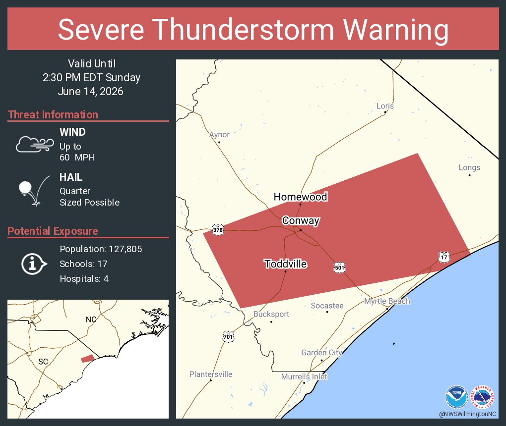
ALT This graphic displays a severe thunderstorm warning plotted on a map. The warning is in effect until 2:30 PM EDT. The warning includes Conway SC, Red Hill SC and Briarcliffe Acres SC. This warning is for Southwestern Horry County in northeastern South Carolina. The threats associated with this warning are wind gusts up to 60 MPH and quarter sized hail. There are 127,805 people in the warning along with 17 schools and 4 hospitals.
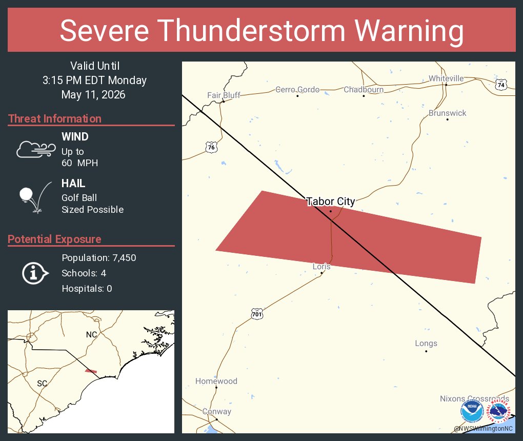
ALT This graphic displays a severe thunderstorm warning plotted on a map. The warning is in effect until 3:15 PM EDT. The warning includes Tabor City NC. This warning is for Southwestern Columbus and North Central Horry Counties. The threats associated with this warning are wind gusts up to 60 MPH and golf ball sized hail. There are 7,450 people in the warning along with 4 schools and 0 hospitals.
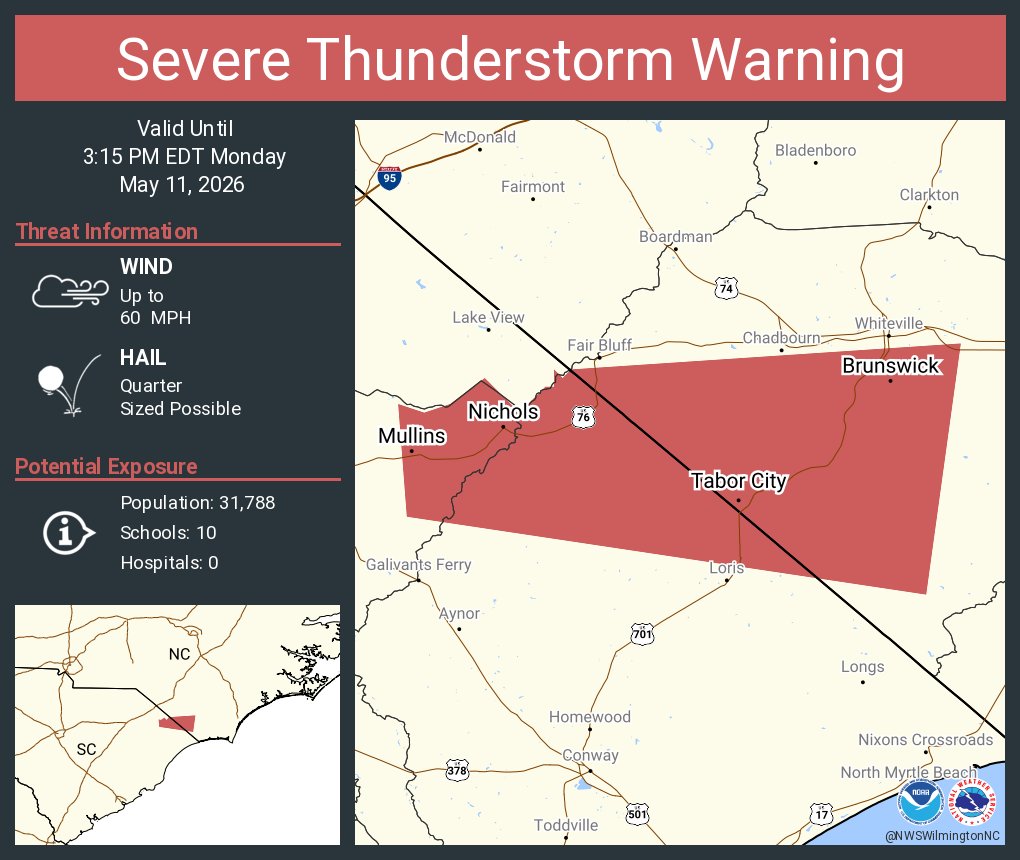
ALT This graphic displays a severe thunderstorm warning plotted on a map. The warning is in effect until 3:15 PM EDT. The warning includes Mullins SC, Tabor City NC and Brunswick NC. This warning is for Southwestern Columbus County in southeastern North Carolina, Northwestern Horry County in northeastern South Carolina and Northeastern Marion County in northeastern South Carolina. The threats associated with this warning are wind gusts up to 60 MPH and quarter sized hail. There are 31,788 people in the warning along with 10 schools and 0 hospitals.
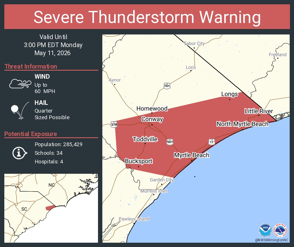
ALT This graphic displays a severe thunderstorm warning plotted on a map. The warning is in effect until 3:00 PM EDT. The warning includes Myrtle Beach SC, Socastee SC and Conway SC. This warning is for Southern Horry County in northeastern South Carolina. The threats associated with this warning are wind gusts up to 60 MPH and quarter sized hail. There are 285,429 people in the warning along with 34 schools and 4 hospitals.
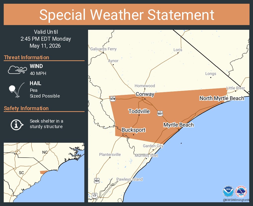
ALT This graphic displays a special weather statement plotted on a map. The statement is in effect until 2:45 PM EDT. The statement includes Myrtle Beach SC, Socastee SC and Conway SC. A STRONG THUNDERSTORM WILL IMPACT NORTHEASTERN GEORGETOWN AND SOUTHERN HORRY COUNTIES THROUGH 245 PM EDT. The threats associated with this storm are wind gusts up to 40 MPH and pea sized hail. Seek shelter in a sturdy structure until the storm passes.
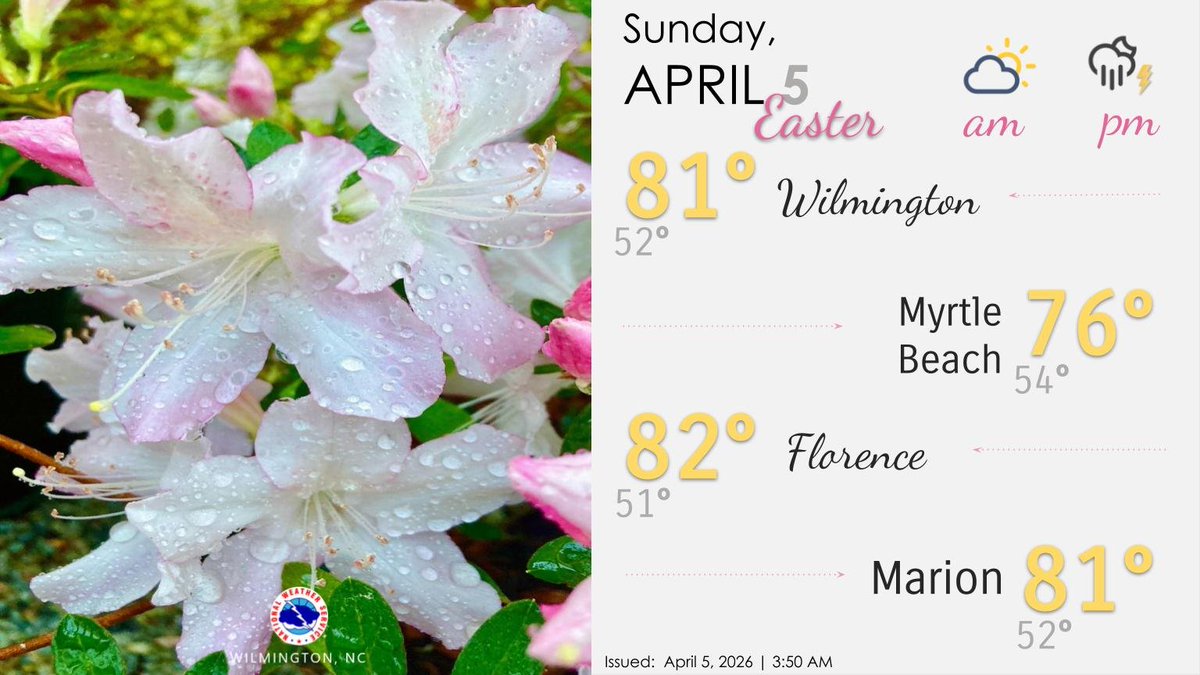
ALT A forecast graphic for Sunday, April 5, 2026. The left side of the screen shows spring flowers covered in raindrops, while the right side of the screen shows forecast information for the day. Hoppy Easter! 🐰🐣 Partly to mostly cloudy and muggy to start our morning. Showers and storms ahead of a cold front will increase this afternoon and evening. Meanwhile, we have a moderate risk of rip currents along all of our beaches.
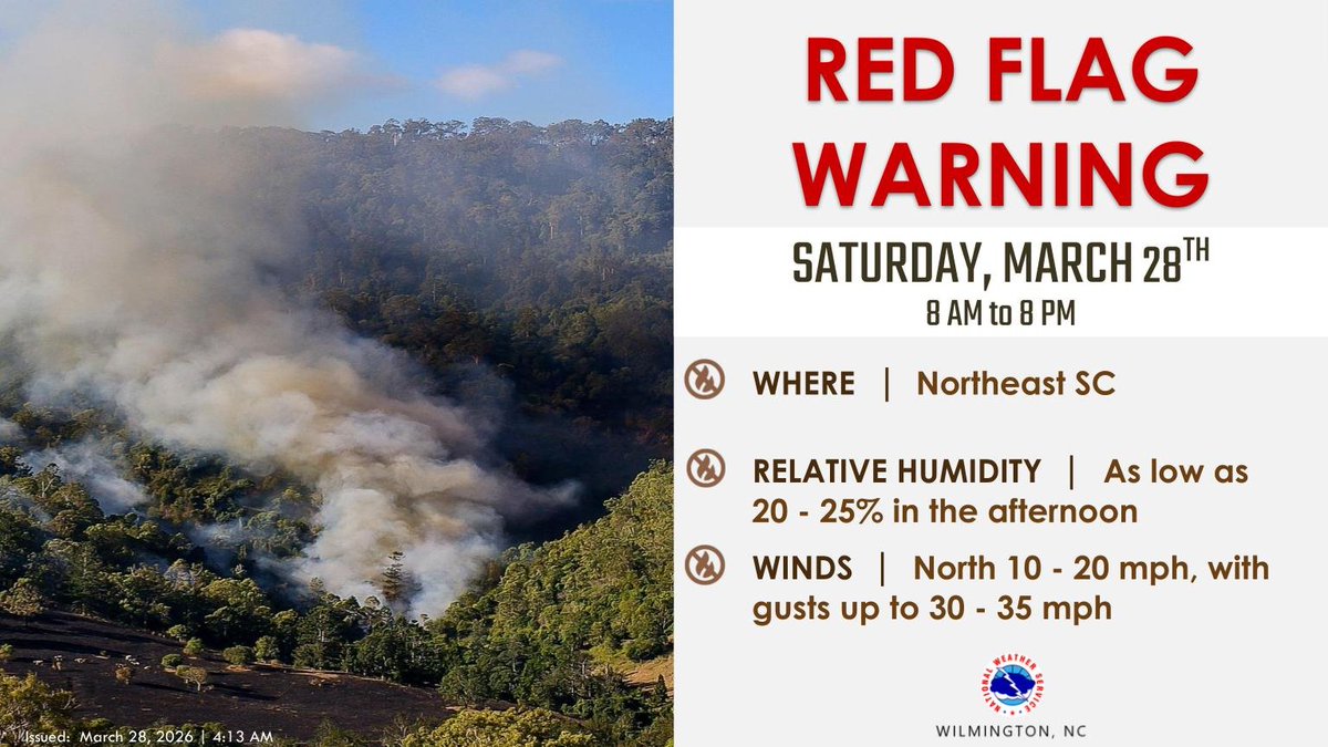
ALT Graphic from the National Weather Service Wilmington, NC, announcing a Red Flag Warning for Saturday, March 28th, 2026. Details: Timing: 8 AM to 8 PM. Where: Northeast SC. Relative Humidity: As low as 20-25% in the afternoon. Winds: North 10-20 mph, with gusts up to 30-35 mph. The left side of the image shows a photo of a wildfire on a wooded hillside with thick white and grey smoke rising into the air above a scorched, black field. Issued: March 28, 2026, at 4:13 AM.
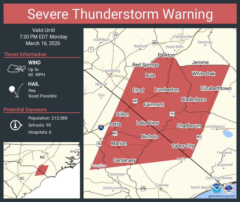
ALT This graphic displays a severe thunderstorm warning plotted on a map. The warning is in effect until 7:30 PM EDT. The warning includes Lumberton NC, Marion SC and Dillon SC. This warning is for Robeson County in southeastern North Carolina, Western Bladen County in southeastern North Carolina, Northwestern Columbus County in southeastern North Carolina, Central Florence County in northeastern South Carolina, Dillon County in northeastern South Carolina, Northwestern Horry County in northeastern South Carolina and Marion County in northeastern South Carolina. The threats associated with this warning are wind gusts up to 60 MPH and pea sized hail. There are 213,588 people in the warning along with 95 schools and 6 hospitals.
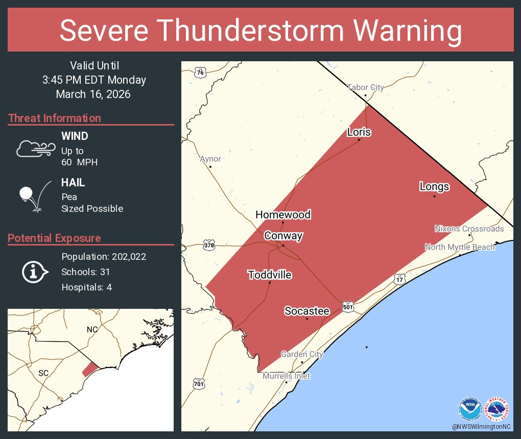
ALT This graphic displays a severe thunderstorm warning plotted on a map. The warning is in effect until 3:45 PM EDT. The warning includes Socastee SC, Conway SC and Red Hill SC. This warning is for Horry County in northeastern South Carolina. The threats associated with this warning are wind gusts up to 60 MPH and pea sized hail. There are 202,022 people in the warning along with 31 schools and 4 hospitals.
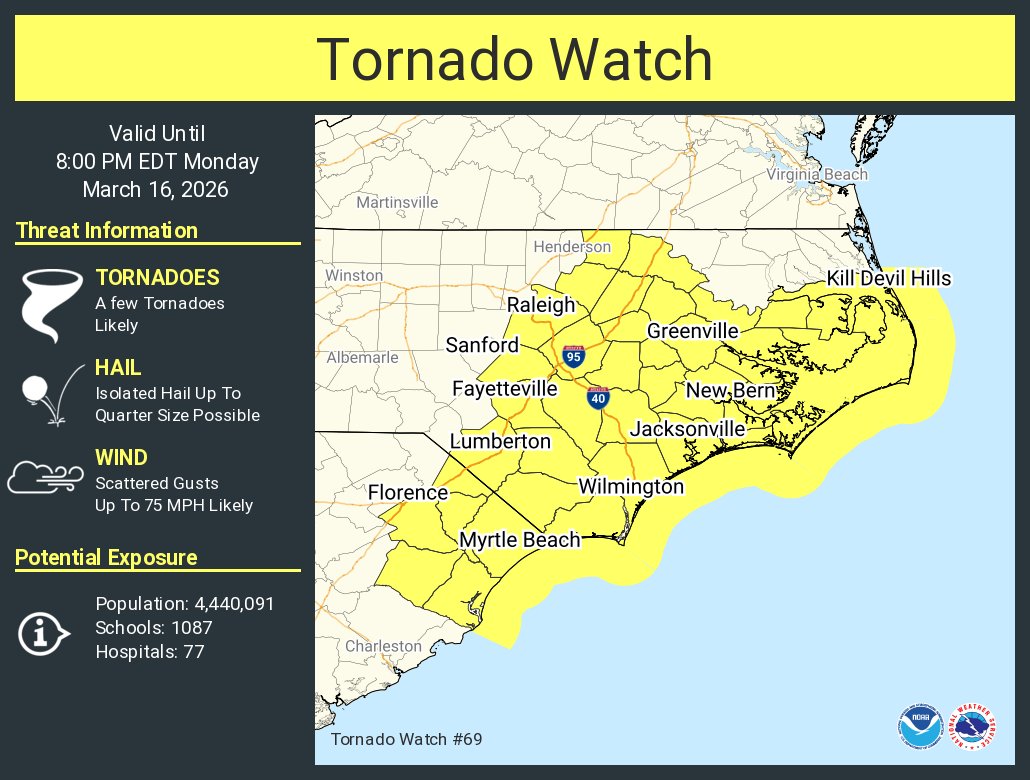
ALT This graphic displays Tornado Watch watch number 69 plotted on a map. The watch is in effect until 8:00 PM EDT. The watch includes parts of North Carolina and South Carolina. The threats associated with this watch are a few tornadoes likely, isolated hail up to quarter size possible and scattered gusts up to 75 mph likely. There are 4,440,091 people in the watch along with 1087 schools and 77 hospitals.
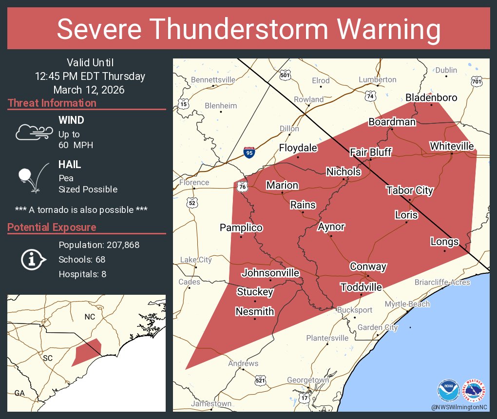
ALT This graphic displays a severe thunderstorm warning plotted on a map. The warning is in effect until 12:45 PM EDT. The warning includes Conway SC, Red Hill SC and Marion SC. This warning is for Southeastern Robeson County in southeastern North Carolina, Southwestern Bladen County in southeastern North Carolina, Columbus County in southeastern North Carolina, Eastern Florence County in northeastern South Carolina, North central Georgetown County in northeastern South Carolina, Southeastern Dillon County in northeastern South Carolina, Horry County in northeastern South Carolina, Marion County in northeastern South Carolina and Northeastern Williamsburg County in northeastern South Carolina. The threats associated with this warning are wind gusts up to 60 MPH and pea sized hail. There are 207,868 people in the warning along with 68 schools and 8 hospitals.
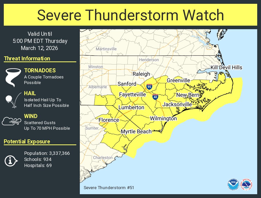
ALT This graphic displays Severe Thunderstorm watch number 51 plotted on a map. The watch is in effect until 5:00 PM EDT. The watch includes parts of North Carolina and South Carolina. The threats associated with this watch are a couple tornadoes possible, isolated hail up to half inch size possible and scattered gusts up to 70 mph possible. There are 3,337,366 people in the watch along with 934 schools and 69 hospitals.


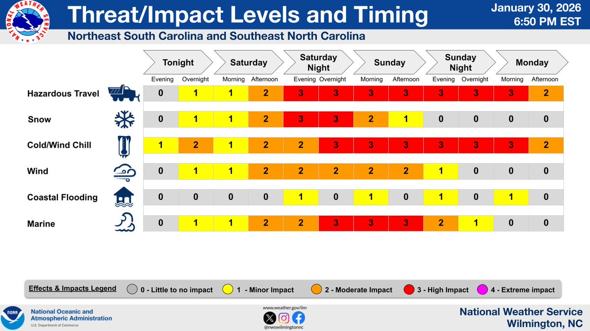
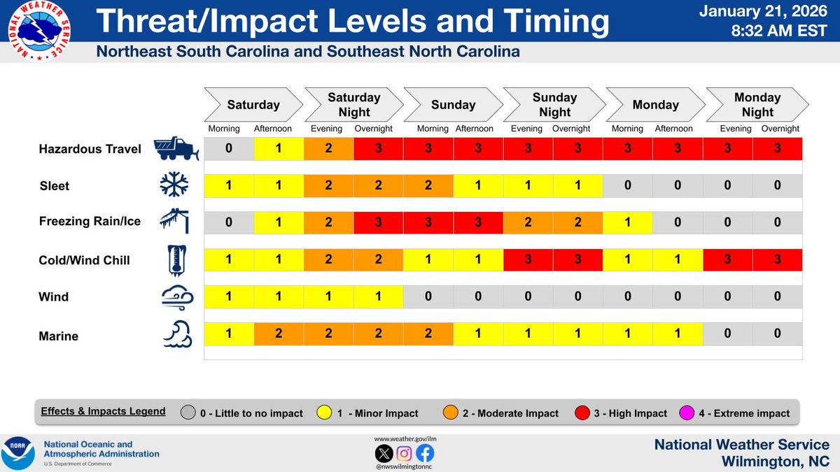
ALT Threat/Impact Levels and Timing Table for Southeast NC & Northeast SC from Saturday to Monday Night. The main areas highlighted are hazardous travel (from Saturday night into next week), freezing rain/ice (Saturday night into Sunday), and dangerous cold (Sunday, Monday, and Tuesday nights).
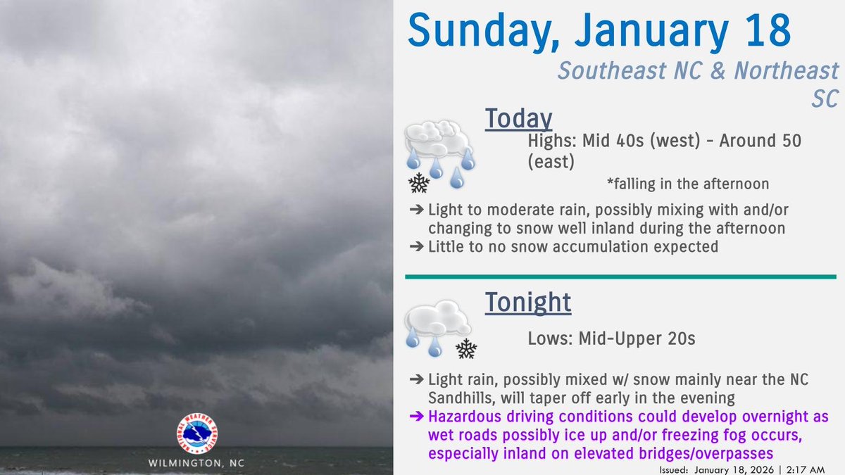
ALT NWS Wilmington, NC Weather Story for SE NC & NE SC for 1/18/26: A passing cold front will bring some much needed rain to the area through early this evening. There is a low to moderate risk that the rain will mix with and/or change over to snow this afternoon, especially west of I-95. Not much snow accumulation is expected but up to an inch could occur in a reasonable worst case scenario, mainly on grassy surfaces. Wet roads will then refreeze tonight, and some fog could develop, which may make driving hazardous into Monday morning before temperatures climb back above freezing by 10 AM.