
Amateur Radio Serving the National Hurricane Center and Mankind Since 1965. Visit our website for more information. hwn.org
Joined August 2024
- Tweets 1,271
- Following 55
- Followers 372
- Likes 3
1,149 Photos and videos
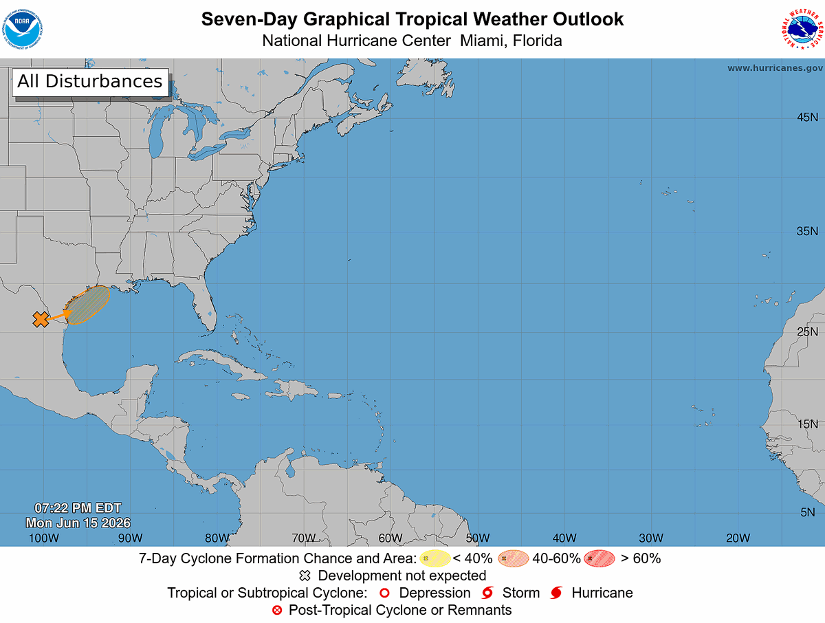


Tropical Weather Outlook
NWS National Hurricane Center Miami FL
800 PM EDT Mon Jun 15 2026
For the North Atlantic...Caribbean Sea and the Gulf of America:
Northwestern Gulf of America:
A trough of low pressure located over northeastern Mexico continues
to produce a large area of disorganized showers and thunderstorms.
Development is not expected during the next day or so while the
trough remains inland. However, the system could re-emerge over the
northwestern Gulf of America late Tuesday or Wednesday, and
environmental conditions there are marginally conducive for the
formation of a short-lived tropical storm on Wednesday into
Thursday.
Regardless of tropical cyclone formation, interests across southern
and eastern Texas and portions of Louisiana and Mississippi should
prepare for periods of intense rainfall over the next several days
which could produce widespread, life-threatening flash, urban, and
river flooding. Gusty winds and coastal flooding are also possible
along portions of the northwestern Gulf Coast, and Tropical Storm
Watches or Warnings could be required on Tuesday. Additional
information on this system can be found in products issued by your
local National Weather Service Forecast Office or NHC Key Messages.
* Formation chance through 48 hours...medium...50 percent.
* Formation chance through 7 days...medium...50 percent.
$$
Forecaster Pasch
#WeatherReadyNation #WRN #SKYWARN #CANWARN #Hamradio #AmateurRadio #SATERN #HurricaneHams
108
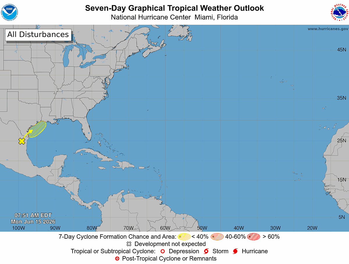
Tropical Weather Outlook
NWS National Hurricane Center Miami FL
800 AM EDT Mon Jun 15 2026
For the North Atlantic...Caribbean Sea and the Gulf of America:
Northwestern Gulf of America:
A trough of low pressure located over northeastern Mexico continues
to produce disorganized shower and thunderstorm activity.
Development is not expected during the next day or so while the
trough remains inland and drifts generally northward over
northeastern Mexico and southern Texas. The system is then forecast
to move northeastward and could re-emerge over the northwestern Gulf
of America late Tuesday or Wednesday, where environmental conditions
may support some development around midweek.
Regardless of tropical cyclone formation, heavy rainfall, flash
flooding and gusty winds are possible across portions of eastern and
southern Texas and Louisiana this week. Additional information on
this system can be found in products issued by your local National
Weather Service Forecast Office.
* Formation chance through 48 hours...low...20 percent.
* Formation chance through 7 days...low...30 percent.
$$
Forecaster Kelly
#WeatherReadyNation #WRN #SKYWARN #CANWARN #Hamradio #AmateurRadio #SATERN #HurricaneHams
84

Jun 14
Tropical Weather Outlook
NWS National Hurricane Center Miami FL
800 AM EDT Sun Jun 14 2026
For the North Atlantic...Caribbean Sea and the Gulf of America:
Northwestern Gulf of America:
A broad area of low pressure located over eastern Mexico is
producing disorganized shower and thunderstorm activity.
Development is not expected during the next day or so while the low
remains inland over northeastern Mexico or southern Texas during the
next day or so. The system could then re-emerge over the
northwestern Gulf of America around midweek while interacting with a
frontal boundary, but conditions there are expected to be only
marginally conducive for development.
* Formation chance through 48 hours...low...near 0 percent.
* Formation chance through 7 days...low...20 percent.
$$
Forecaster Adams/Blake
1
2
89
Jun 13
Tropical Weather Outlook
NWS National Hurricane Center Miami FL
200 PM EDT Sat Jun 13 2026
For the North Atlantic...Caribbean Sea and the Gulf of America:
Southwestern Gulf of America:
A broad area of low pressure just offshore of eastern Mexico
is producing disorganized shower and thunderstorm activity.
Significant development is not anticipated before the low moves
inland over eastern Mexico by early Sunday. The system could
re-emerge over the northwestern Gulf of America on Tuesday or
Wednesday while interacting with a frontal boundary, but conditions
there are expected to be only marginally conducive for development.
* Formation chance through 48 hours...low...10 percent.
* Formation chance through 7 days...low...20 percent.
$$
Forecaster Blake
#WeatherReadyNation #WRN #SKYWARN #CANWARN #Hamradio #AmateurRadio #SATERN #HurricaneHams
1
89
Jun 13
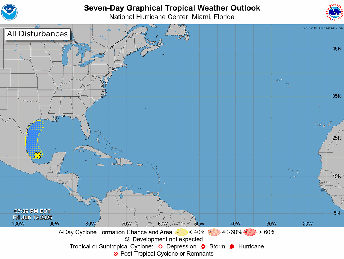
Tropical Weather Outlook
NWS National Hurricane Center Miami FL
800 PM EDT Fri Jun 12 2026
For the North Atlantic...Caribbean Sea and the Gulf of America:
Western Gulf:
A broad low pressure area moving west-northwestward over the Bay of
Campeche is accompanied by poorly organized showers and
thunderstorms. Environmental conditions are forecast to be only
marginally conducive for development before the system moves inland
over eastern Mexico late Saturday or Sunday. The system could
re-emerge over the northwestern Gulf on Tuesday and Wednesday while
interacting with a frontal boundary, but there too, conditions are
only expected to be marginally conducive for any development.
* Formation chance through 48 hours...low...20 percent.
* Formation chance through 7 days...low...20 percent.
$$
Forecaster Beven
#WeatherReadyNation #WRN #SKYWARN #CANWARN #Hamradio #AmateurRadio #SATERN #HurricaneHams
97
Jun 12
Tropical Weather Outlook
NWS National Hurricane Center Miami FL
800 AM EDT Fri Jun 12 2026
For the North Atlantic...Caribbean Sea and the Gulf of America:
Western Gulf:
A broad area of low pressure has formed over the far southern Bay
of Campeche and is producing disorganized showers and thunderstorms.
Environmental conditions are forecast to be only marginally
conducive for development before the system moves inland over
eastern Mexico late Saturday or Sunday. The system could re-emerge
over the northwestern Gulf on Tuesday and Wednesday while
interacting with a frontal boundary, but there too, conditions are
only expected to be marginally conducive for any development.
* Formation chance through 48 hours...low...10 percent.
* Formation chance through 7 days...low...10 percent.
$$
Forecaster Berg
#WeatherReadyNation #WRN #SKYWARN #CANWARN #Hamradio #AmateurRadio #SATERN #HurricaneHams
80
Jun 11
Hello Everyone,
My apologies for being a day late in sharing this information.
On Wednesday, June 10, Dr. Phil Klotzbach of Colorado State University issued his first update to the 2026 Atlantic Hurricane Season forecast. In his update, he stated:
"We have reduced our 2026 Atlantic basin hurricane season forecast and anticipate a below-normal season. Warm neutral ENSO conditions are likely to transition to El Niño shortly, with a high potential for a moderate to strong El Niño during the peak of hurricane season. Sea surface temperatures in the western tropical Atlantic are near average but are cooler than normal in the eastern and central tropical Atlantic. We anticipate El Niño being the dominant factor for the upcoming hurricane season, driving increased levels of tropical Atlantic vertical wind shear. We are forecasting a below-average probability for major hurricane landfalls along the continental United States coastline and in the Caribbean. As with all hurricane seasons, coastal residents are reminded that it only takes one hurricane making landfall to make it an active season. Thorough preparations should be made every season, regardless of predicted activity."
Dr. Klotzbach's initial forecast, issued on April 9, called for 13 named storms, 6 hurricanes, and 2 major hurricanes (Category 3 or stronger). His updated forecast now calls for 11 named storms, 5 hurricanes, and 2 major hurricanes.
Regardless of any seasonal forecast, it only takes one landfalling hurricane to make it a memorable and destructive season. Need a reminder? Think back to Hurricane Andrew in 1992.
When is the best time to prepare for a hurricane? The answer is simple: NOW.
If you need a Family Emergency Plan or Emergency Preparedness Checklist, please visit our website at HWN.org. Near the bottom of the page, you will find a section titled "Great Downloadable Information" containing resources to help you and your family prepare before a storm threatens.
Take care, stay prepared, and God Bless.
Bobby Graves
KB5HAV
Net Manager
President
Hurricane Watch Net
#WeatherReadyNation #WRN #SKYWARN #CANWARN #Hamradio #AmateurRadio #SATERN #HurricaneHams
72
Jun 11
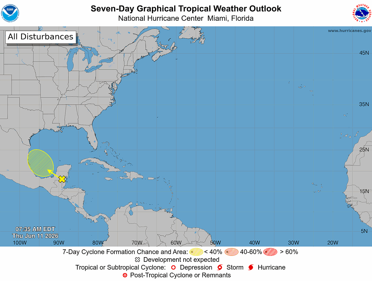
Tropical Weather Outlook
NWS National Hurricane Center Miami FL
800 AM EDT Thu Jun 11 2026
For the North Atlantic...Caribbean Sea and the Gulf of America:
Bay of Campeche:
A broad area of low pressure is likely to form over the Bay of
Campeche on Friday from a westward-moving tropical wave currently
located over the Yucatan Peninsula of Mexico. Environmental
conditions are forecast to be only marginally conducive for
development before the system moves inland over eastern Mexico late
Saturday or Sunday.
* Formation chance through 48 hours...low...10 percent.
* Formation chance through 7 days...low...10 percent.
$$
Forecaster Berg
#WeatherReadyNation #WRN #SKYWARN #CANWARN #Hamradio #AmateurRadio #SATERN #HurricaneHams
1
1
438
Jun 10
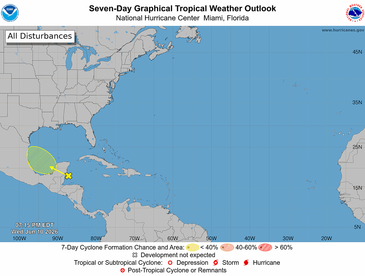
Tropical Weather Outlook
NWS National Hurricane Center Miami FL
800 PM EDT Wed Jun 10 2026
For the North Atlantic...Caribbean Sea and the Gulf of America:
Bay of Campeche:
A broad area of low pressure could form over the Bay of Campeche on
Friday from a westward-moving tropical wave currently located over
the northwestern Caribbean Sea. Environmental conditions are
forecast to be only marginally conducive for development, and the
system should move inland over eastern Mexico by late this weekend.
* Formation chance through 48 hours...low...10 percent.
* Formation chance through 7 days...low...10 percent.
$$
Forecaster Adams/Papin
#WeatherReadyNation #WRN #SKYWARN #CANWARN #Hamradio #AmateurRadio #SATERN #HurricaneHams
1
1
202
Jun 10
Tropical Weather Outlook
NWS National Hurricane Center Miami FL
800 AM EDT Wed Jun 10 2026
For the North Atlantic...Caribbean Sea and the Gulf of America:
Bay of Campeche:
A broad area of low pressure could form over the Bay of Campeche
late this week. Conditions are not expected to be favorable for
significant development, and the system should move inland over
eastern Mexico late this weekend.
* Formation chance through 48 hours...low...near 0 percent.
* Formation chance through 7 days...low...10 percent.
$$
Forecaster Pasch
#WeatherReadyNation #WRN #SKYWARN #CANWARN #Hamradio #AmateurRadio #SATERN #HurricaneHams

136
Tropical Weather Outlook
NWS National Hurricane Center Miami FL
800 AM EDT Mon Jun 8 2026
For the North Atlantic...Caribbean Sea and the Gulf of America:
Tropical cyclone formation is not expected during the next 7 days.
$$
Forecaster Bucci
#WeatherReadyNation #WRN #SKYWARN #CANWARN #Hamradio #AmateurRadio #SATERN #HurricaneHams
50
Tropical Weather Outlook
NWS National Hurricane Center Miami FL
800 AM EDT Sun Jun 7 2026
For the North Atlantic...Caribbean Sea and the Gulf of America:
Tropical cyclone formation is not expected during the next 7 days.
$$
Forecaster Roberts
#WeatherReadyNation #WRN #SKYWARN #CANWARN #Hamradio #AmateurRadio #SATERN #HurricaneHams
84
Tropical Weather Outlook
NWS National Hurricane Center Miami FL
800 AM EDT Sat Jun 6 2026
For the North Atlantic...Caribbean Sea and the Gulf of America:
Tropical cyclone formation is not expected during the next 7 days.
$$
Forecaster Roberts
#WeatherReadyNation #WRN #SKYWARN #CANWARN #Hamradio #AmateurRadio #SATERN #HurricaneHams
51
Tropical Weather Outlook
NWS National Hurricane Center Miami FL
200 AM EDT Fri Jun 5 2026
For the North Atlantic...Caribbean Sea and the Gulf of America:
Tropical cyclone formation is not expected during the next 7 days.
$$
Forecaster Berg
#WeatherReadyNation #WRN #SKYWARN #CANWARN #Hamradio #AmateurRadio #SATERN #HurricaneHams
1
53
Tropical Weather Outlook
NWS National Hurricane Center Miami FL
800 AM EDT Thu Jun 4 2026
For the North Atlantic...Caribbean Sea and the Gulf of America:
Tropical cyclone formation is not expected during the next 7 days.
$$
Forecaster Reinhart/Adams
#WeatherReadyNation #WRN #SKYWARN #CANWARN #Hamradio #AmateurRadio #SATERN #HurricaneHams
96
Tropical Weather Outlook
NWS National Hurricane Center Miami FL
800 AM EDT Wed Jun 3 2026
For the North Atlantic...Caribbean Sea and the Gulf of America:
Tropical cyclone formation is not expected during the next 7 days.
$$
Forecaster Reinhart
#WeatherReadyNation #WRN #SKYWARN #CANWARN #Hamradio #AmateurRadio #SATERN #HurricaneHams

59
Tropical Weather Outlook
NWS National Hurricane Center Miami FL
800 AM EDT Tue Jun 2 2026
For the North Atlantic...Caribbean Sea and the Gulf of America:
Tropical cyclone formation is not expected during the next 7 days.
$$
Forecaster Kelly
#WeatherReadyNation #WRN #SKYWARN #CANWARN #Hamradio #AmateurRadio #SATERN #HurricaneHams
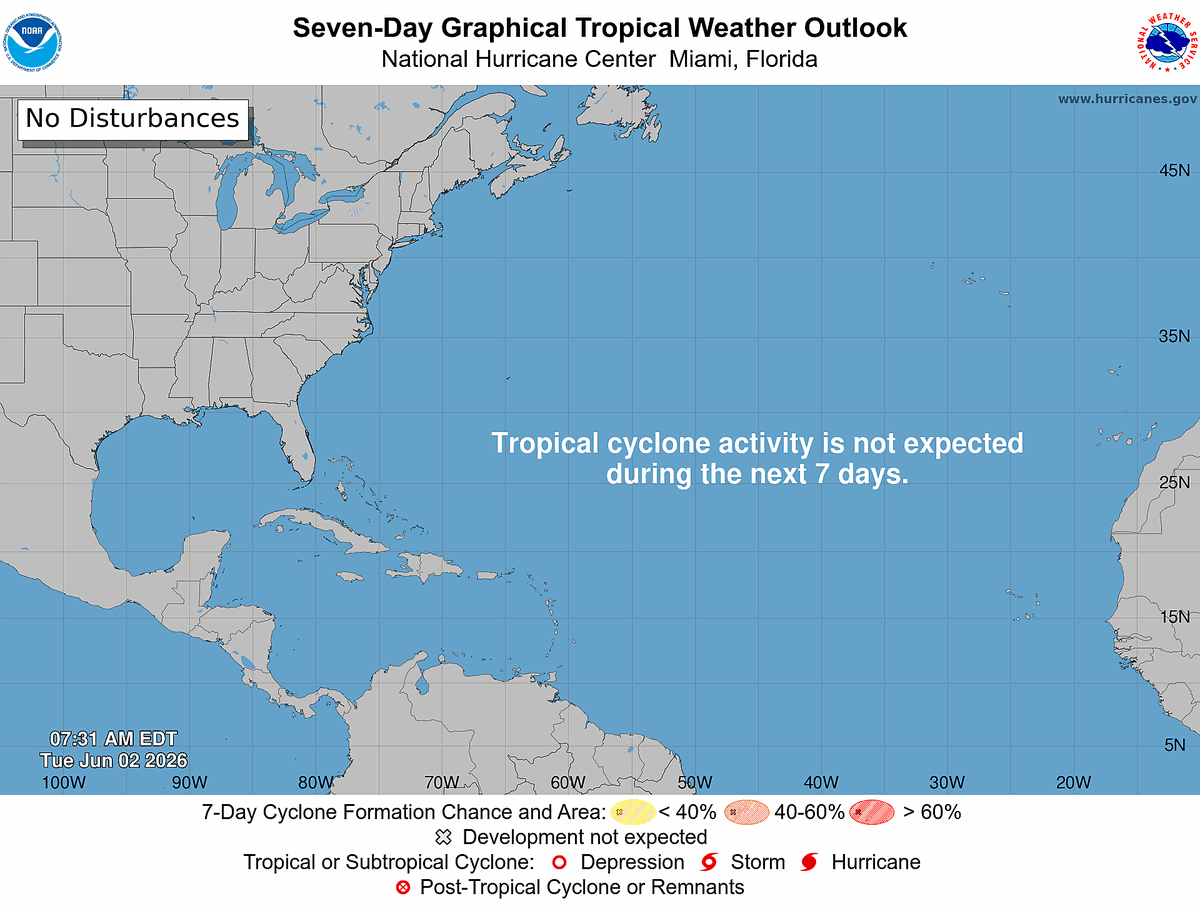
59
Tropical Weather Outlook
NWS National Hurricane Center Miami FL
800 AM EDT Mon Jun 1 2026
For the North Atlantic...Caribbean Sea and the Gulf of America:
Tropical cyclone formation is not expected during the next 7 days.
&&
Today marks the first day of the Atlantic hurricane season, which
will run until November 30. The long-term averages for the number of
named storms, hurricanes, and major hurricanes are 14, 7, and 3,
respectively.
The list of names for 2026 is as follows:
Name Pronunciation Name Pronunciation
--------------------------------------------------------------------
Arthur AR-thur Leah LEE-ah
Bertha BUR-thuh Marco MAR-koe
Cristobal krees-TOH-bahl Nana NA-na
Dolly DAH-lee Omar OH-mar
Edouard eh-DWARD Paulette pawl-LET
Fay fay Rene re-NAY
Gonzalo gohn-SAH-loh Sally SAL-ee
Hanna HAN-uh Teddy TEHD-ee
Isaias ees-ah-EE-ahs Vicky VIH-kee
Josephine JOH-seh-feen Wilfred WILL-fred
Kyle KY-ull
A full list of Atlantic basin tropical cyclone names and
pronunciations can be found at:
nhc.noaa.gov/pdf/aboutnames_…
This product, the Tropical Weather Outlook, briefly describes
significant areas of disturbed weather and their potential for
tropical cyclone formation during the next seven days. The issuance
times of this product are 2 AM, 8 AM, 2 PM, and 8 PM EDT. After the
change to standard time in November, the issuance times are 1 AM,
7 AM, 1 PM, and 7 PM EST.
A Special Tropical Weather Outlook will be issued to provide
updates, as necessary, in between the regularly scheduled issuances
of the Tropical Weather Outlook. Special Tropical Weather Outlooks
will be issued under the same WMO and AWIPS headers as the regular
Tropical Weather Outlooks.
A standard package of products, consisting of the tropical cyclone
public advisory, the forecast/advisory, the cyclone discussion, and
a wind speed probability product is issued every six hours for all
ongoing tropical cyclones. In addition, a special advisory package
may be issued at any time to advise of significant unexpected
changes or to modify watches or warnings.
NHC has the option to issue advisories, watches, and warnings for
disturbances that are not yet a tropical cyclone, but which pose the
threat of bringing tropical storm or hurricane conditions to land
areas within 72 hours. For these land-threatening "potential
tropical cyclones", NHC will issue the full suite of advisory and
watch/warning products. Potential tropical cyclones share the
naming conventions currently in place for tropical depressions,
being numbered from a single list (e.g., "One", "Two", "Three",
etc.).
The Tropical Cyclone Update is a brief statement to inform of
significant changes in a tropical cyclone, to post or cancel watches
or warnings, or to provide hourly position updates between
intermediate advisories when the storm center is easily followed by
radar. It can also be used in lieu of or to precede the issuance of
a special advisory package. Tropical Cyclone Updates, which can be
issued at any time, can be found under the WMO header WTNT61-65
KNHC, and under AWIPS header MIATCUAT1-5.
All NHC text and graphical products are available on the web at
hurricanes.gov. More information on NHC text and
graphical products can be found at
nhc.noaa.gov/pdf/NHC_Product….
New and updated products for the 2026 season can be found at
nhc.noaa.gov/pdf/2026NHCNewP…
You can also interact with NHC on Facebook at
facebook.com/NWSNHC. Notifications are available via X
when select National Hurricane Center products are issued.
Information about our Atlantic X feed (@NHC_Atlantic) is available
at nhc.noaa.gov/socialmedia/.
$$
Forecaster Pasch
#WeatherReadyNation #WRN #SKYWARN #CANWARN #Hamradio #AmateurRadio #SATERN #HurricaneHams

1
2
169
May 31
Tropical Weather Outlook
NWS National Hurricane Center Miami FL
800 AM EDT Sun May 31 2026
For the North Atlantic...Caribbean Sea and the Gulf of America:
Tropical cyclone formation is not expected during the next 7 days.
$$
Forecaster Pasch
#WeatherReadyNation #WRN #SKYWARN #CANWARN #Hamradio #AmateurRadio #SATERN #HurricaneHams

98