
Fascinated by extreme weather and the extreme events that come with it. (Any fantasy hour maps posted are for entertainment & learning purposes, not forecasts.)
Joined June 2021
- Tweets 3,284
- Following 522
- Followers 8,897
- Likes 4,832
1,203 Photos and videos


Pinned Tweet

2 Jun 2024
Happy Hurricane Season to all who celebrate!
14
19
218
123,506
Matthew Gross retweeted

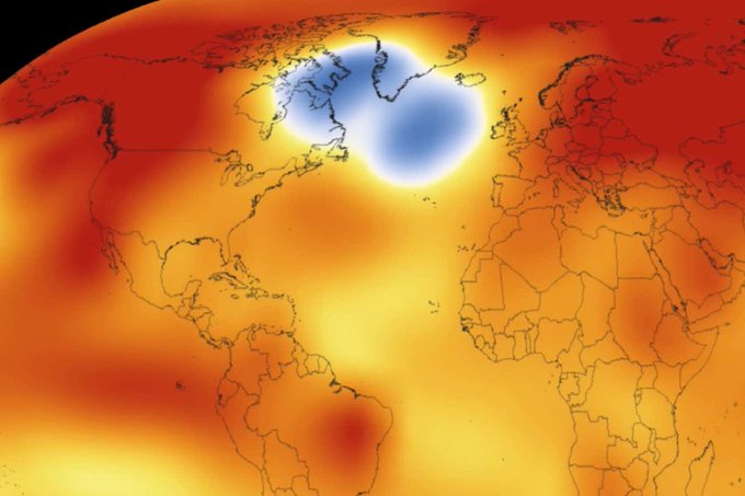
Mysterious ‘cold blob’ in the Atlantic suggests the AMOC is weakening
A patch of ocean south-east of Greenland is the only place on Earth that is cooling, and it could be a sign that the warm water “conveyor belt” in the Atlantic is slowing down
newscientist.com/article/252…
docs.google.com/document/d/1…
497
1,805
7,639
17,408,822
I really don't think enough people fully comprehend the worlds that are about to collide here.
You already have people in geopolitical circles warning about the threat of famine based on surging prices / availability of fertilizer components, and you also have long-term weather modeling all converging on a worst case scenario for a building El Nino event, which will peak near the end of the year. These are two slow moving but entirely predictable disasters that when coupled together will each make the other orders of magnitude worse. (This will take months to fully unfold, but at this point, the die is cast.)
There's no event in our history books that combines the current global population with the impending fertilizer shortage and the strength of the El Nino that's coming. We are about to witness an unprecedented event that will push crops around the globe to their limit.

Famine is coming
66
872
2,904
294,579
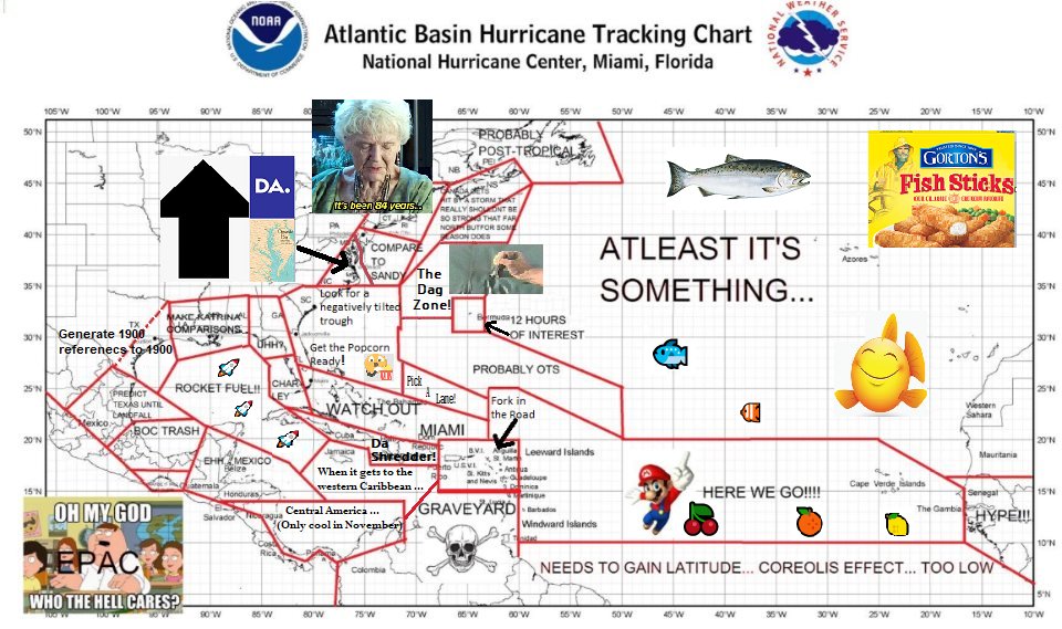
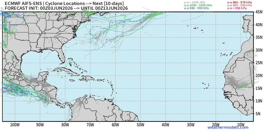
Anybody who is hyping the Atlantic this year is clueless! It's always possible coastal residents roll an unlucky pair of dice and we get one or even two high impact individual storms, but this is easily the most hostile headwinds the basin has faced in at least a decade.
Jun 3

Despite the early season hype...not seeing anything to be concerned about!
1
25
3,764
Matthew Gross retweeted

Jun 3
2026 and 1997 are El Niño twins by several measures.
But there is more warm water available in 2026, which gives this year's El Niño a higher intensity ceiling.
x.com/BenNollWeather/status/…
May 28

2026 and 1997 are El Niño twins. But they didn't always look alike.
Subsurface ocean warmth developed faster in 1997, but 2026 caught up following a record-breaking Kelvin wave that formed in April.
A new westerly wind burst into June will keep these two years neck and neck.
3
24
95
14,865
It's June 1st, and normally that means all eyes turn to the Atlantic at the beginning of another hurricane season. But this year, I can't take my eyes off what's brewing in the equatorial Pacific. While a Super El Nino has been likely for weeks now, the latest westerly wind burst in the region should turn things into a run away freight train over the next ten days or so, locking us into a "die has been cast" situation. From there, it's just a matter of how high we peak in the late fall / early winter months, and based on the latest guidance, it seems increasingly likely that records are going down.

3
15
74
5,487
Matthew Gross retweeted

May 30
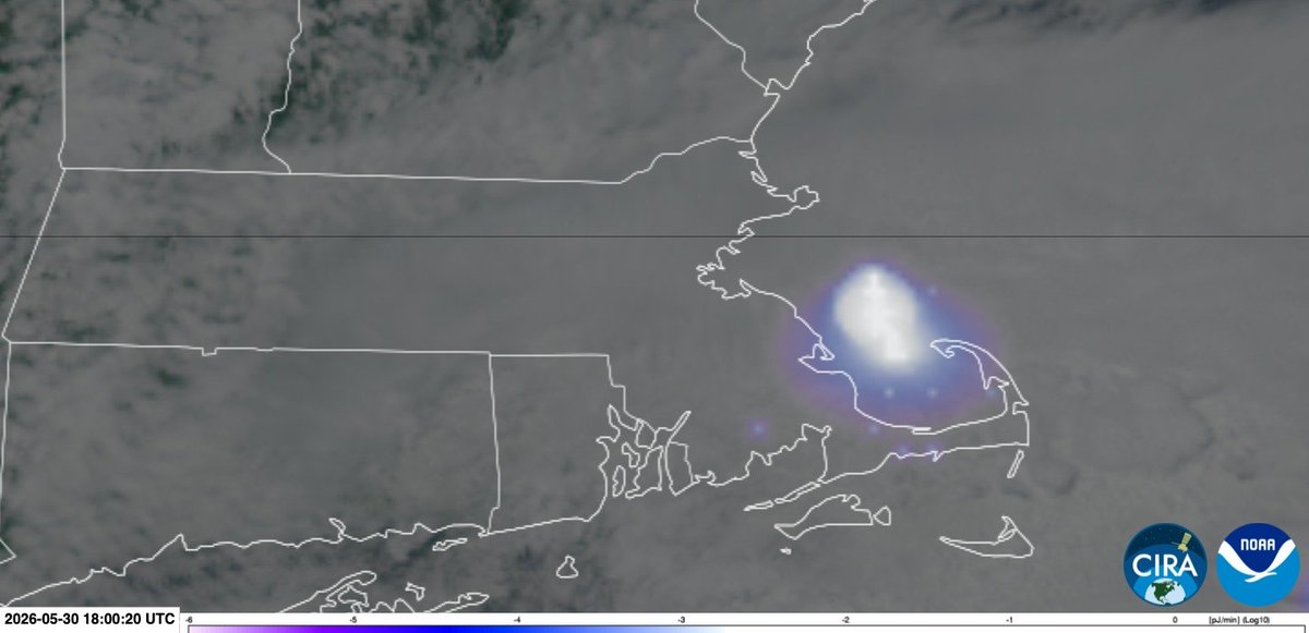
DID YOU HEAR IT?
Thousands across southern New England, especially near Boston, reported a loud boom just after 2 p.m. GOES-19’s Geostationary Lightning Mapper suggests a meteor exploded in the atmosphere east of Boston. No earthquakes were detected. (Courtesy CIRA/NOAA.)
8
18
120
14,762
Matthew Gross retweeted

May 22
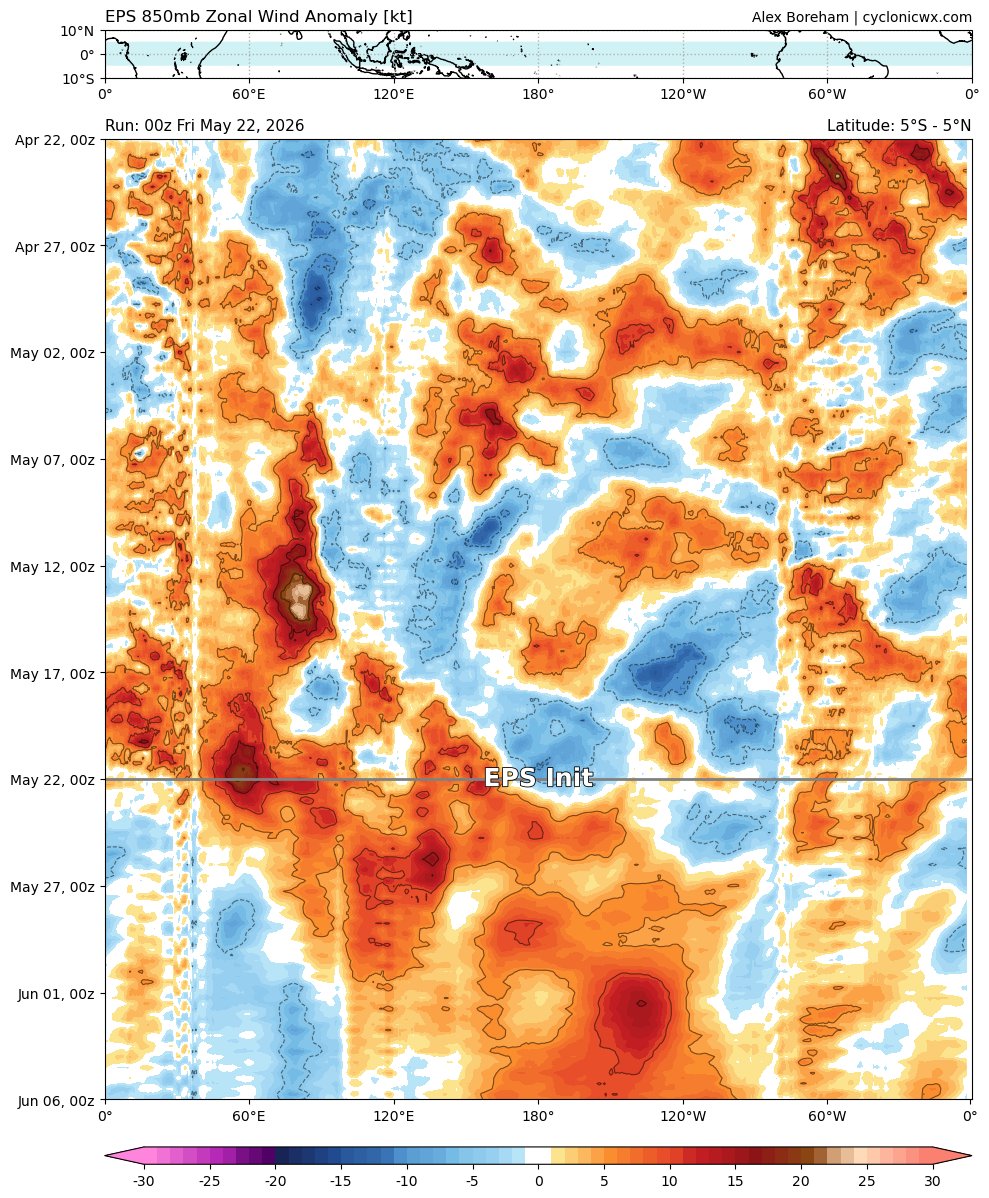
Getting this sort of MJO-driven reinforcement of the developing #ElNiño with a massive westerly wind burst is a pretty good indicator that this event is going to be a very strong one. No sustained easterlies to interrupt the last Kelvin Wave, and this next WWB should push the warm pool even further east. Probably why even the *relative* SST anomalies are pushing 3-3.5C in some of the latest forecasts.

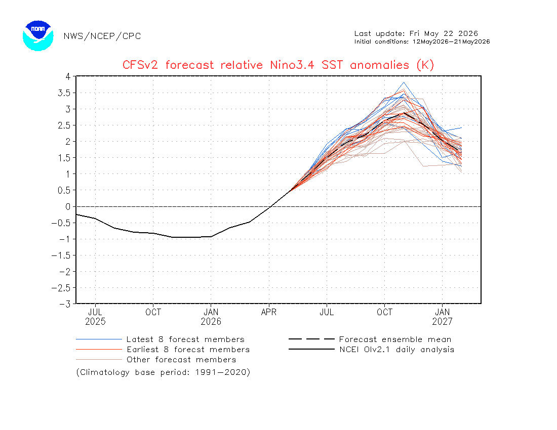
9
34
145
10,243
Matthew Gross retweeted
May 20
A freight train of warm water chugging beneath the surface of the Pacific Ocean is a big reason why a super El Niño may form this year.
Ocean waters have peaked around 7.5˚C (13.5˚F) above average, breaking records.
And now, it's nearing the western shores of South America 🧵
16
160
582
54,811
Matthew Gross retweeted

I don't understand why only a few people, like Mathew Gross, understand just how bad this whole combination of Super El Niño on top of out of control climate change fertilizer shortages and energy crisis all hitting at the same time is going to actually be. It kind of reminds me of the flooding situation that forecasters were warning about in the Carolinas ahead of Helene- everyone was just kind of like, ok, we get it, there's going to be a lot of rain, but nobody could comprehend just how terrible the situation was going to actually get until 3-4 days after all the missing people couldn't be found alive. If you have any friends in places around the world where famine could hit later this year, please make them aware of how bad it's going to get, and make sure they have a plan to stay alive!
May 17

Lurking below the surface in the equatorial Pacific is possibly the most impressive blob of above average ocean temperatures we've ever recorded since we've had the ability to measure this stuff. When that enormous concentration of bath water reaches the surface over the coming weeks and months, it's going to release devastating consequences around the globe throughout the second half of the year. Get ready for severe droughts in parts of South America, Africa, and Australia, devastating monsoons in southern China, and a roaring southern jet all winter long in North America. When you combine this with the fertilizer crisis bubbling as a byproduct of current global events, there's going to be crop failure on a level most of us have never seen during the closing months of 2026. Hard to see how we avoid widespread deadly famines across multiple stretches of the planet at this point.
68
372
2,119
215,287
May 17
Lurking below the surface in the equatorial Pacific is possibly the most impressive blob of above average ocean temperatures we've ever recorded since we've had the ability to measure this stuff. When that enormous concentration of bath water reaches the surface over the coming weeks and months, it's going to release devastating consequences around the globe throughout the second half of the year. Get ready for severe droughts in parts of South America, Africa, and Australia, devastating monsoons in southern China, and a roaring southern jet all winter long in North America. When you combine this with the fertilizer crisis bubbling as a byproduct of current global events, there's going to be crop failure on a level most of us have never seen during the closing months of 2026. Hard to see how we avoid widespread deadly famines across multiple stretches of the planet at this point.
422
1,458
5,131
1,177,141
May 18
Just so everybody is clear, it's not the El Nino alone that's so uniquely problematic. It's the combination of the strength of the El Nino with the coming fertilizer shortage. Both of these are slow moving and enormously impactful events that have already been set in motion and won't fully manifest until the back half of the year. However, once they show their face, their impacts will feed off each other and exacerbate shortages around the globe.
21
83
765
54,788
Matthew Gross retweeted

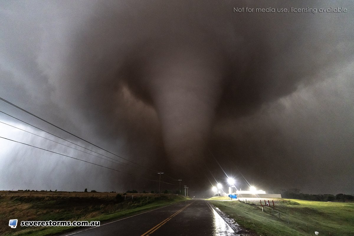
Apr 24
The terrifying view of the tornado near Enid, Oklahoma this evening as it crossed the road. Join our live streams & watch the full chase edit coming up via youtube.com/@DanielShawAU/
189
2,095
10,973
927,720
Matthew Gross retweeted

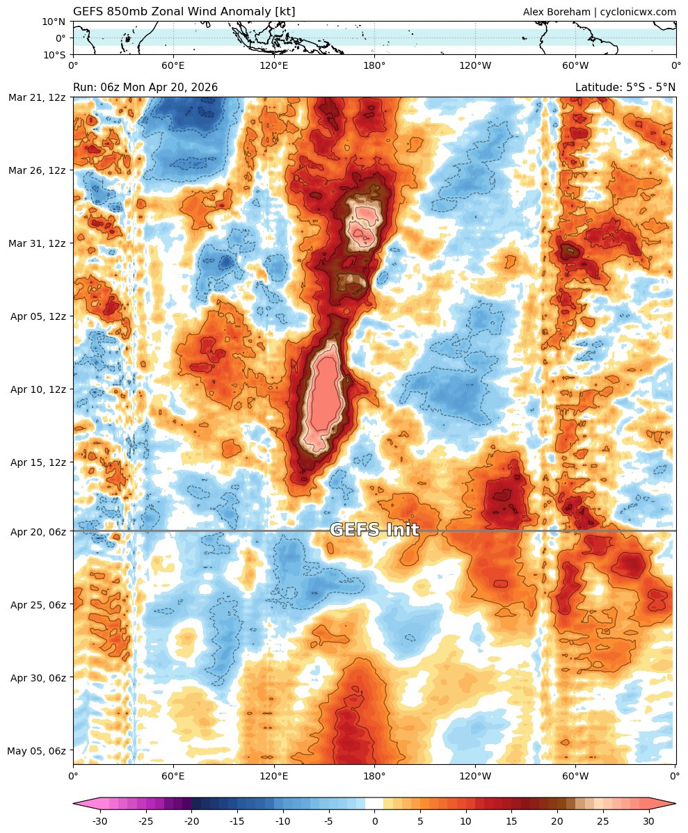
Apr 20
But wait, there's more! Signal of another WWB (and perhaps some TC activity) early next month as the MJO comes through the Pacific again. There won't be a shortage of these in the summer!
5
13
91
5,036
Matthew Gross retweeted
Apr 15
Big changes afoot in the Pacific. The past month of WWB activity has pushed a great amount of warm water to the dateline, and the PMM continues to intensify. We'll soon have the powerful warm pool surface, and by the end of the month may have a solid El Nino signature
7
37
174
13,076
Matthew Gross retweeted

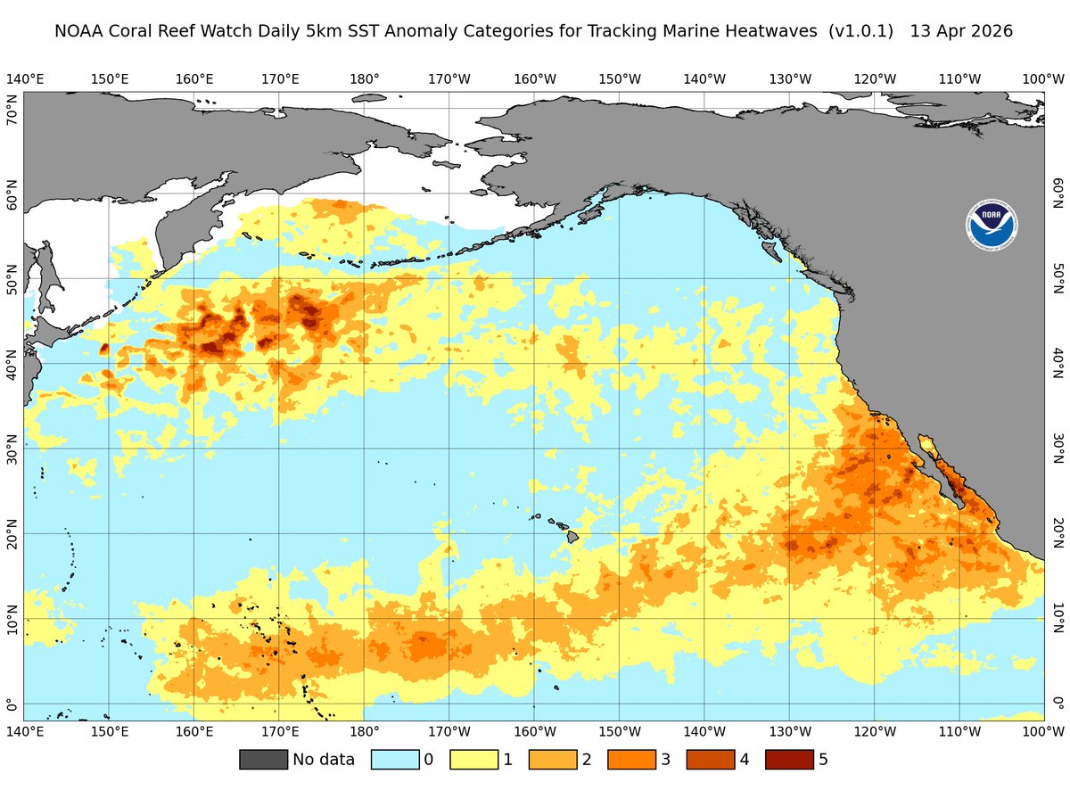
Apr 15
California’s coastal waters are the warmest ever recorded for April.
A severe to extreme marine heatwave is underway off the coasts of California and Baja California, locally reaching Category 5 intensity.
There is just a ton of warm water across the Pacific, with a strong to severe marine heatwave conditions extending from the Marshall Islands all the way to the California coastline.
Expect a very humid summer in Southern California, along with major impacts on marine ecosystems. With a strengthening, potentially Super El Niño expected by autumn, if there were ever a year for a hurricane to make landfall in SoCal, this would be it.
We’ll be watching closely for El Niño to rapidly emerge in the coming weeks.
147
608
2,733
247,993
Matthew Gross retweeted

Apr 14
Of COURSE noted weather enthusiast Mike Trout homered off Weathers!!!!!!!!!!!!!!!!
h/t @NJ_baseball

"The Mike Trout Show continues" 😤
Mike Trout CRUSHES his 3rd home run of the series!
4
28
413
22,313
Matthew Gross retweeted

Apr 13
Severe thunderstorms capable of producing golf ball sized hail and wind gusts up to 60mph have fired across southern Minnesota this evening. The good news for Red Sox vs. Twins is the front to the north is slowly sagging south and has just about reached Minneapolis. It needs to pass through the city to ensure these cells stay south of the game.
1
3
1,042
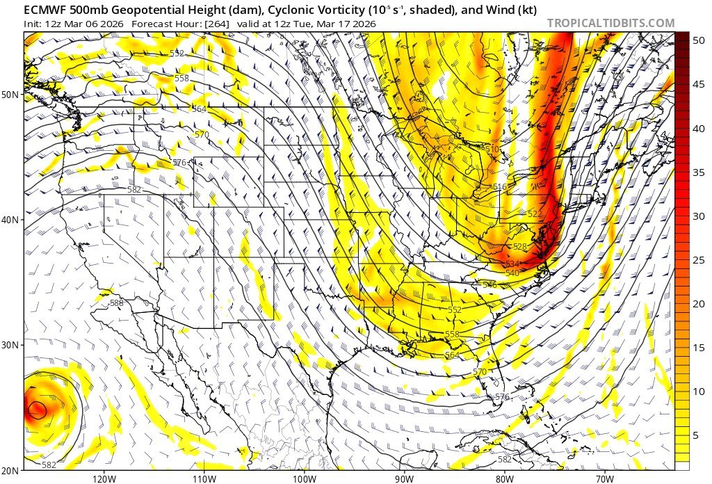
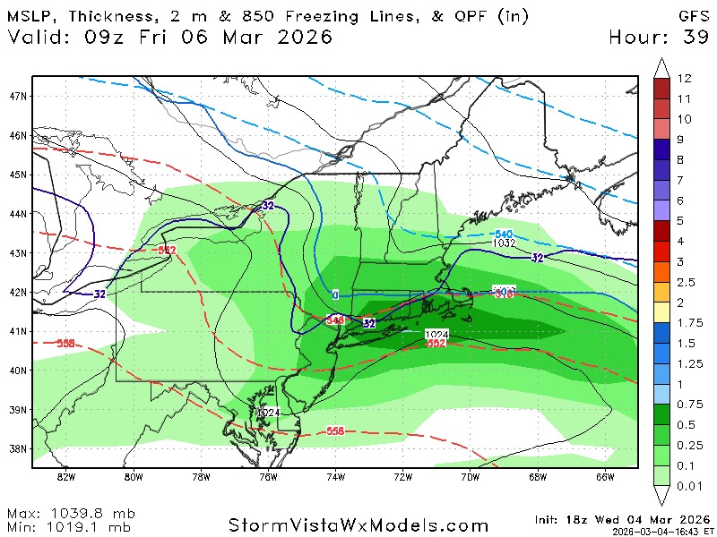
If you're looking for one last dose of winter in the northeast, the best shot may be around March 16th / 17th. A ridge tries to reform in the west, a bunch of little systems race across North America in the mid range before this period, which could potentially clog up the flow, and there should be plenty of vorticity to play with over the eastern half of the country.
However, even with these factors in place, I'd bet on something messy rather than major. With the general flow we have in the jet stream right now, it's just going to be incredibly difficult to get any sort of significant energy to bundle in the southeast U.S. and do any real digging east of the Mississippi River. The Euro kind of shows it well here today at 12z as the overall look is relatively favorable, but too much energy races north out ahead, and any southern stream energy trying to trail the northern vort tilting negative is late to the party. This will keep evolving in the coming days and there's a ton of shortwaves between now and then that can keep changing the flow, but this is the window to keep an eye on if things align. As is always the case in weather, we'll have to wait and see.
23
2,579
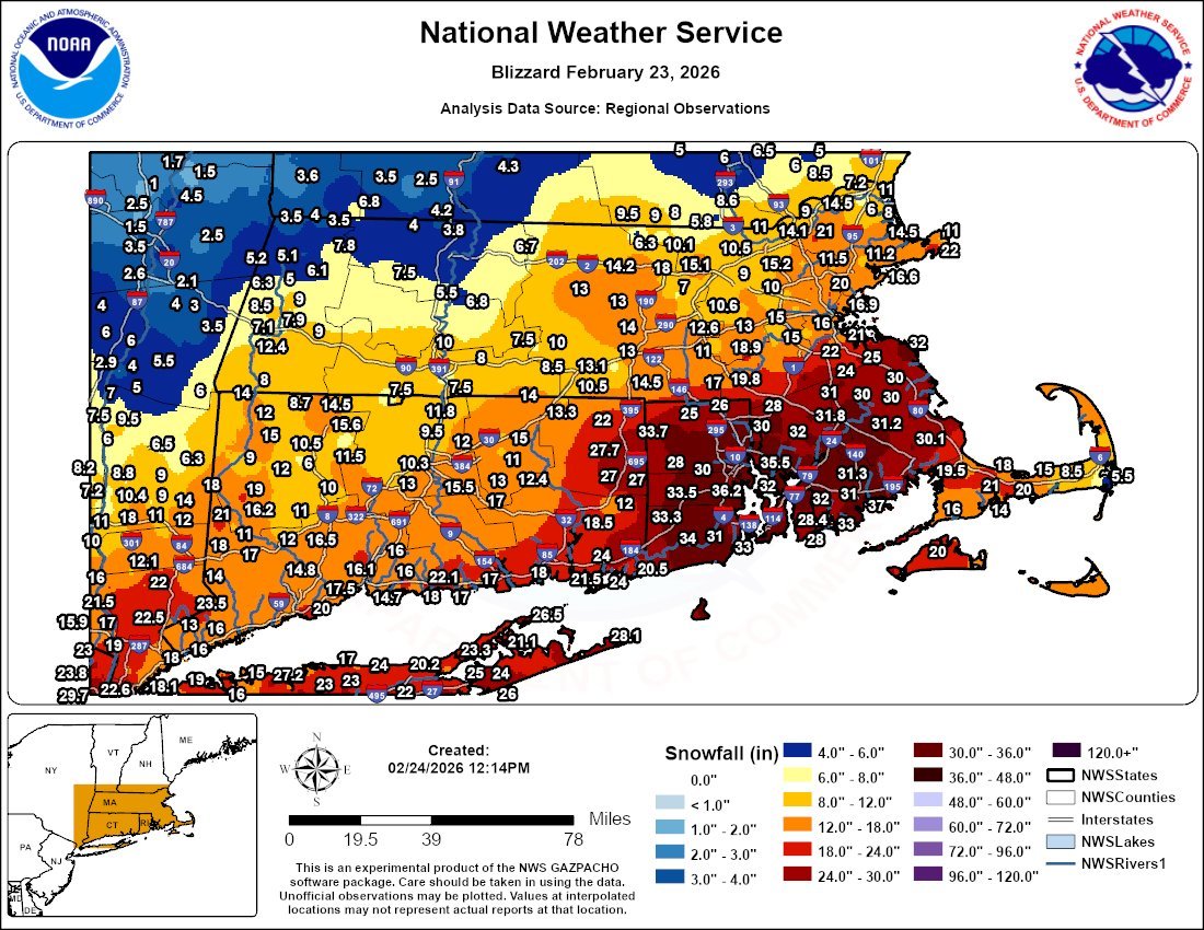
The theme of the winter continues! Models are trending colder and further south as we get closer to an event. The GFS is now featuring straight up snow along the I-90 corridor from Albany to Boston and has freezing surface temperatures getting dammed to the Connecticut coastline by late Thursday night.
4
2
32
6,782
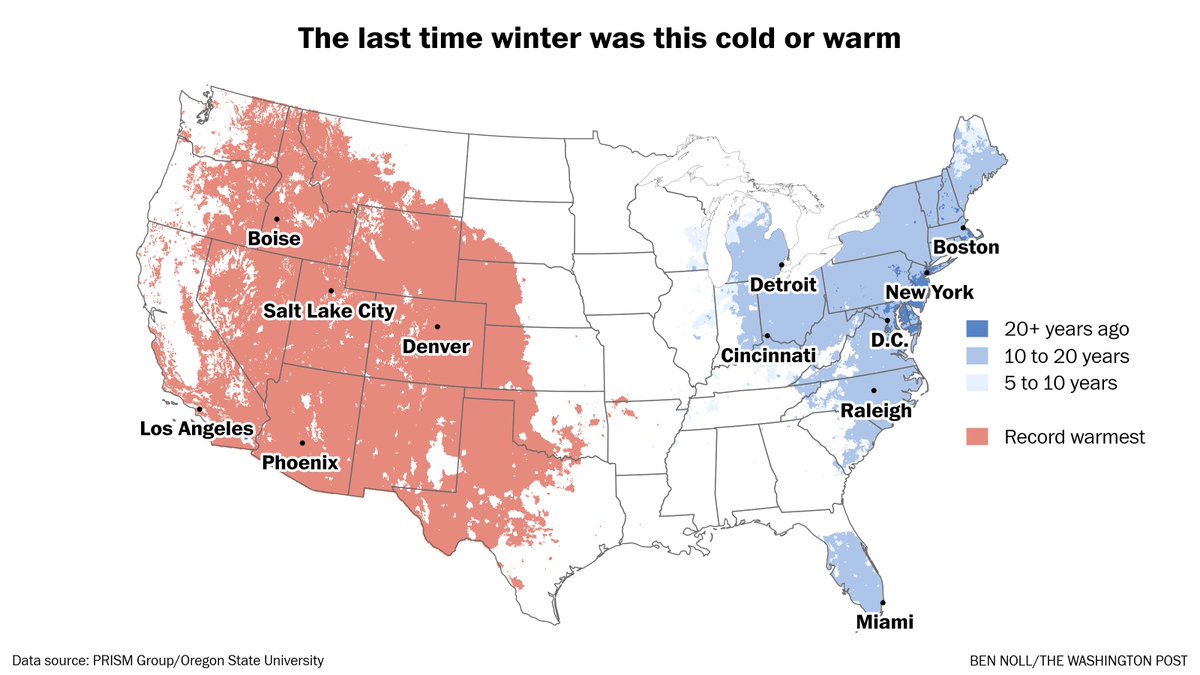
Much of the country experienced its warmest winter on record while the population centers of the northeast experienced their coldest winter in many, many years. This is consistent with the general trend we've been seeing of late: Winters across the northern hemisphere are getting warmer, but if you get in those pockets where it's below average in any given season, the conditions can be incredibly severe.
Mar 1
Hello spring! Meteorological winter is over.
The season featured record warmth in the West and was the coldest in a decade or more in the East.
According to preliminary data, it was the second warmest winter on record for the contiguous United States as a whole.
2
1
38
7,344